close
-
Layers w
- Weather Layers
- Pro
- Pro
- Pro
- Pro
- Pro
- Pro
- More Layers
- Pro
- Pro
- Pro
- Pro
-
Upgrade to

3D
Trail Conditions
- Unknown
- Snow Groomed
- Snow Packed
- Snow Covered
- Snow Cover Partial
- Freeze/thaw Cycle
- Icy
- Prevalent Mud
- Wet
- Variable
- Ideal
- Dry
- Very Dry
Trail Flow (Ridden Direction)
Trailforks scans users ridelogs to determine the most popular direction each trail is ridden. A good flowing trail network will have most trails flowing in a single direction according to their intension.
The colour categories are based on what percentage of riders are riding a trail in its intended direction.
The colour categories are based on what percentage of riders are riding a trail in its intended direction.
- > 96%
- > 90%
- > 80%
- > 70%
- > 50%
- < 50%
- bi-directional trail
- no data
Trail Last Ridden
Trailforks scans ridelogs to determine the last time a trail was ridden.
- < 2 days
- < 1 week
- < 2 weeks
- < 1 month
- < 6 months
- > 6 months
Trail Ridden Direction
The intended direction a trail should be ridden.
- Downhill Only
- Downhill Primary
- Both Directions
- Uphill Primary
- Uphill Only
- One Direction
Contribute Details
Colors indicate trail is missing specified detail.
- Description
- Photos
- Description & Photos
- Videos
Trail Popularity ?
Trailforks scans ridelogs to determine which trails are ridden the most in the last 9 months.
Trails are compared with nearby trails in the same city region with a possible 25 colour shades.
Think of this as a heatmap, more rides = more kinetic energy = warmer colors.
- most popular
- popular
- less popular
- not popular
ATV/ORV/OHV Filter
Max Vehicle Width
inches
US Cell Coverage
Legend

Radar Time
Activity Recordings
Trailforks uses anonymized public activity data.
?
Activity Recordings
Trailforks uses anonymized public activity data.
?
Personal Heatmap
▶
Activity Types
all
/
none
▶
Options
2
Date range
month
–
Winter Trails
Warning
A routing network for winter maps does not exist. Selecting trails using the winter trails layer has been disabled.
Missing Trails
Most Popular
Least Popular
Trails are colored based on popularity. The more popular a trail is, the more red. Less popular trails trend towards green.
Jump Magnitude Heatmap
Heatmap of where riders jump on trails. Zoom in to see individual jumps, click circles to view jump details.
BC Backroad Status
![map legend]()
Service Road Atlas is a free to use, community-driven service for viewing and creating reports on the numerous back-country service roads around B.C. and Alberta.

Slope Aspect
Direction the slope faces
Trails Deemphasized
Trails are shown in grey.
Only show trails with no bike usage.
Suggested Layers
Based on selected activity type
Save the current map location and zoom level as your default home location whenever this page is loaded.
Save
No description for Elko has been added yet!
Login or register to submit one.
Activities Click to view
- Mountain Bike
30 trails
- E-Bike
3 trails
- Gravel Bike
0 trails
- Adaptive Bike
0 trails
- Horse
31 trails
- Hike
59 trails
- Trail Running
55 trails
Region Details
- 2
- 11
- 12
- 5
Region Status
Caution as of May 14, 2026Stats
- Avg Trail Rating
- Trails (view details)
- 59
- Trails Mountain Bike
- 30
- Trails E-Bike
- 3
- Trails Horse
- 31
- Trails Hike
- 59
- Trails Trail Running
- 55
- Trails Dirtbike/Moto
- 1
- Trails ATV/ORV/OHV
- 1
- Trails Downhill Ski
- 3
- Trails Backcountry Ski
- 1
- Total Distance
- 113 miles
- Total Descent
- 17,091 ft
- Total Vertical
- 8,041 ft
- Highest Trailhead
- 10,889 ft
- Reports
- 50
- Photos
- 10
- Ridden Counter
- 605
Articles
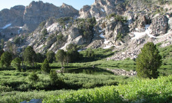
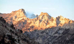
Elko, NV: Ruby Crest National Recreation Trail
Sep 19, 2013 from backpacker.com
Dazzling high-country lakes, glacier-carved cirques and miles of stunning alpine scenery render this secluded 38-mile National Recreation Trail a...
Grand Traverses: Ruby Crest
Jun 21, 2013 from backpacker.com
Soak up the alpine solitude in the "Swiss Alps of Nevada".
Sub Regions
-
Elko Snobowl Ski and Bike Park
- 9
- 14
- 1
-
Lamoille Canyon
Popular Elko Mountain Biking Trails
• 80 ★ 5.0 • 9 miles • 1,408 ft • 22 •
Common loop ride. It ends near pavement so you can route yourself back to starting point or take dirt roads back to trailhead for another loop. Can be ridden in reverse but has some steeper climbing sections going in reverse. Find water...
• ★ 0.0 • 328 ft • 8 ft • 5 •
Blue difficulty singletrack. This multi-use trail can be used both directions and has a moderate overall physical rating.
• ★ 4.0 • 2,277 ft • 0 ft • 4 •
Blue difficulty singletrack. This multi-use trail can be used both directions and has a moderate overall physical rating.
• ★ 3.0 • 1 mile • 340 ft • 4 •
Blue difficulty singletrack. This multi-use trail can be used both directions and has a moderate overall physical rating.
• ★ 0.0 • 1,112 ft • 0 ft • 4 •
Blue difficulty singletrack. This multi-use trail can be used both directions and has a moderate overall physical rating.
• ★ 0.0 • 2,776 ft • 2 ft • 4 •
Blue difficulty singletrack. This multi-use trail can be used both directions and has a moderate overall physical rating.
• ★ 0.0 • 1,857 ft • 0 ft • 4 •
Blue difficulty singletrack. This multi-use trail can be used both directions and has a moderate overall physical rating.
• ★ 0.0 • 935 ft • 78 ft • 4 •
Blue difficulty singletrack. This multi-use trail can be used both directions and has a moderate overall physical rating.
Elko Mountain Bike Routes
★ 5.0 • 7 miles • 820 ft • 0 • Loop •
Park at the Snobowl parking lot and ride the switchback climb to the top then link it to the backside...
44 miles • 1,837 ft • 0 •
This is an endurance Mixed surface ride. Very little to no traffic on the dirt and gravel roads. Rideable...
Photos of Elko Mountain Bike
Recent Trail Reports
Activity Feed
| username | action | type | title | date |
|---|---|---|---|---|
| Howserkr | wishlist | region | activity #95118255 | May 20, 2026 @ 10:31am May 20, 2026 |
| krsbr79 | comment | trail | activity #94733437 and 1 more | May 14, 2026 @ 10:49pm May 14, 2026 |
| krsbr79 | vote | trail | activity #94733425 and 2 more | May 14, 2026 @ 10:49pm May 14, 2026 |
| krsbr79 | add | report | activity #94733412 and 9 more | May 14, 2026 @ 10:48pm May 14, 2026 |
| mattymajors | add | report | activity #94197054 | May 6, 2026 @ 8:45pm May 6, 2026 |
Recent Comments
| username | type | title | comment | date |
|---|---|---|---|---|
| trail | It’s singletrack, in Elko. It’s not buffed... | May 14, 2026 @ 10:50pm May 14, 2026 | ||
| trail | Trails need a good weekend of maintenance,... | May 14, 2026 @ 10:49pm May 14, 2026 | ||
| trail | We followed a previous comment and rode in the... | May 1, 2024 @ 5:57pm May 1, 2024 | ||
| report | Agreed. Lots o crickets. No signage. Side by... | Aug 9, 2023 @ 10:00pm Aug 9, 2023 | ||
| trail | Would highly reccomend in reverse. Rode it the... | Apr 14, 2019 @ 8:22pm Apr 14, 2019 |
Local Badges
-

Epic Ride Descent 2k1 awarded -

Descent 10k Badge2 awarded -

Descent 100k Badge0 awarded
Activity Type Stats
| activitytype | trails | distance | descent | descent distance | total vertical | rating | global rank | state rank | photos | reports | routes | ridelogs |
|---|---|---|---|---|---|---|---|---|---|---|---|---|
| Mountain Bike | 30 | 37 miles | 2,785 ft | 11 miles | 5,492 ft | #7,627 | #2,500 | 9 | 50 | 2 | 1,596 | |
| E-Bike | 3 | 22 miles | 2,096 ft | 8 miles | 2,251 ft | #5,477 | #1,703 | 48 | 25 | |||
| Horse | 31 | 89 miles | 14,669 ft | 25 miles | 4,623 ft | #745 | #565 | |||||
| Hike | 59 | 113 miles | 17,090 ft | 35 miles | 8,041 ft | #2,002 | #851 | 1 | 46 | 473 | ||
| Trail Running | 55 | 108 miles | 16,299 ft | 34 miles | 8,041 ft | #1,997 | #644 | 46 | 22 | |||
| Dirtbike/Moto | 1 | 3 miles | 167 ft | 988 ft | 1 | |||||||
| ATV/ORV/OHV | 1 | 3 miles | 167 ft | 988 ft | 1 | |||||||
| Downhill Ski | 3 | 3 | ||||||||||
| Backcountry Ski | 1 | 2 miles | 200 ft | 3,340 ft | 259 ft | 92 |
Frequently Asked Questions About Elko
▼
What are the best places to ride in Elko?
Elko has 4 areas to explore for mountain biking. The top rated areas are:
▼
What are the highest rated mountain biking trails in Elko?
The highest rated mountain biking trails in Elko are:
- Little Gem to Claim Boundary (4.1/5)
- Segunda Creek (0/5)
- Long Canyon (0/5)
- Jump Track (0/5)
- North End Loop (0/5)
▼
What is the best time of the year to ride in Elko?
Based on ride log data, the most popular months to ride in Elko are:
- July (29 activities)
- August (14 activities)
- April (14 activities)
▼
Where can I park to ride in Elko?
There are 5 parking locations listed in Elko. The most popular parking spots are:
- Roads End Trailhead
- Elko Snobowl Ski and Bike Park Parking Area
- Soldier Creek Trailhead
- Krenka Creek Trailhead
- Parking
- By racingwiththewind & contributors
- Admins: apply
- #16817 - 6,093 views
- elko activity log | embed map of Elko mountain bike trails | elko mountain biking points of interest
Downloading of trail gps tracks in kml & gpx formats is enabled for Elko.
You must login to download files.