close
-
Layers w
- Weather Layers
- Pro
- Pro
- Pro
- Pro
- Pro
- Pro
- More Layers
- Pro
- Pro
- Pro
- Pro
-
Upgrade to

3D
Trail Conditions
- Unknown
- Snow Groomed
- Snow Packed
- Snow Covered
- Snow Cover Partial
- Freeze/thaw Cycle
- Icy
- Prevalent Mud
- Wet
- Variable
- Ideal
- Dry
- Very Dry
Trail Flow (Ridden Direction)
Trailforks scans users ridelogs to determine the most popular direction each trail is ridden. A good flowing trail network will have most trails flowing in a single direction according to their intension.
The colour categories are based on what percentage of riders are riding a trail in its intended direction.
The colour categories are based on what percentage of riders are riding a trail in its intended direction.
- > 96%
- > 90%
- > 80%
- > 70%
- > 50%
- < 50%
- bi-directional trail
- no data
Trail Last Ridden
Trailforks scans ridelogs to determine the last time a trail was ridden.
- < 2 days
- < 1 week
- < 2 weeks
- < 1 month
- < 6 months
- > 6 months
Trail Ridden Direction
The intended direction a trail should be ridden.
- Downhill Only
- Downhill Primary
- Both Directions
- Uphill Primary
- Uphill Only
- One Direction
Contribute Details
Colors indicate trail is missing specified detail.
- Description
- Photos
- Description & Photos
- Videos
Trail Popularity ?
Trailforks scans ridelogs to determine which trails are ridden the most in the last 9 months.
Trails are compared with nearby trails in the same city region with a possible 25 colour shades.
Think of this as a heatmap, more rides = more kinetic energy = warmer colors.
- most popular
- popular
- less popular
- not popular
ATV/ORV/OHV Filter
Max Vehicle Width
inches
US Cell Coverage
Legend

Radar Time
Activity Recordings
Trailforks uses anonymized public activity data.
?
Activity Recordings
Trailforks uses anonymized public activity data.
?
Personal Heatmap
▶
Activity Types
all
/
none
▶
Options
2
Date range
month
–
Winter Trails
Warning
A routing network for winter maps does not exist. Selecting trails using the winter trails layer has been disabled.
Missing Trails
Most Popular
Least Popular
Trails are colored based on popularity. The more popular a trail is, the more red. Less popular trails trend towards green.
Jump Magnitude Heatmap
Heatmap of where riders jump on trails. Zoom in to see individual jumps, click circles to view jump details.
BC Backroad Status
![map legend]()
Service Road Atlas is a free to use, community-driven service for viewing and creating reports on the numerous back-country service roads around B.C. and Alberta.

Slope Aspect
Direction the slope faces
Trails Deemphasized
Trails are shown in grey.
Only show trails with no bike usage.
Suggested Layers
Based on selected activity type
Save the current map location and zoom level as your default home location whenever this page is loaded.
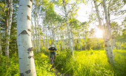
SaveEmerald Mountain (also known as Quarry Mountain) is a popular year-round, day-use recreation area in Steamboat Springs, Colorado, offering extensive hiking, mountain biking, horseback riding, and nordic skiing. It features two summits (approx. 8,250 ft) with scenic Yampa Valley views.
The popular "frontside" of Emerald Mountain is owned by the City of Steamboat Springs and offers over 24 miles of non-motorized multi-use recreational trails.
The popular "frontside" of Emerald Mountain is owned by the City of Steamboat Springs and offers over 24 miles of non-motorized multi-use recreational trails.
Primary Trail Type: All-Mountain & Downhill
Land Status: City Managed
Land Manager: City of Steamboat
 google parking directions
 Access Info:
Blackmere Trailhead
From the west side of Steamboat Springs at Lincoln Avenue/Highway 40 in Steamboat Springs, turn west on on 13th Street. After a short distance, turn left onto Gilpin Street and then left onto Saratoga Avenue (which becomes Fairview Drive). Take the first right to Routt Street and park at the marked trailhead. This is a residential area, please be respectful of driveways.
Howelsen Hill Trailhead
From Lincoln Avenue/Highway 40 in Steamboat Springs turn west on 5th Street, cross the river on the bridge, and turn right on Howelsen Parkway which leads to several trailheads in this complex, most popular being the Stables Trailhead on the western side of the parking lot. Turn left at the stop sign on Howelsen Parkway and follow this road to the dead-end near the public restrooms.
Disclaimer:
All trails are for non-motorized use only. This is a very popular area, so make sure to tread lightly. No hunting is allowed at any time of year. Make sure to clean up after your dogs as this is becoming a problem at times and irresponsibility could lead to more regulations.
Region Supporters & Maintainers
IMBA Ride Center

Steamboat Bike Town
Activities Click to view
- Mountain Bike
54 trails
- Gravel Bike
14 trails
- Horse
1 trails
- Hike
51 trails
- Trail Running
51 trails
- Snowshoe
1 trails
- Backcountry Ski
1 trails
- Nordic Ski
1 trails
Region Details
- 10
- 3
- 35
- 6
Region Status
Open as of May 29, 2026Stats
- Avg Trail Rating
- Trails (view details)
- 54
- Trails Mountain Bike
- 54
- Trails Gravel Bike
- 14
- Trails Horse
- 1
- Trails Hike
- 51
- Trails Trail Running
- 51
- Trails Snowshoe
- 1
- Trails Backcountry Ski
- 1
- Trails Nordic Ski
- 1
- Total Distance
- 37 miles
- Total Descent
- 7,521 ft
- Total Vertical
- 1,549 ft
- Highest Trailhead
- 8,253 ft
- Reports
- 1,129
- Photos
- 292
- Ridden Counter
- 40,770
Articles
Colorado's 5 Most Popular Trail Networks According to Trailforks Data
Oct 20, 2021 from pinkbike.com
Colorado is the eighth most expansive of the 50 states by area and is home to 53 different mountain peaks in excess of 14,000 feet above sea level.
Popular Emerald Mountain Mountain Biking Trails
• 100 ★ 4.9 • 4,564 ft • 0 ft • 2,134 •
Basically the exact same as upper but stepped up slightly in size. The jumps seem to be a bit larger but are still rollable for beginner riders.
• 100 ★ 4.0 • 3,023 ft • 16 ft • 2,126 •
Popular green difficulty singletrack. This mountain bike primary trail can be used downhill only. On average it takes 2 minutes to complete this trail.
• 100 ★ 3.3 • 2,284 ft • 5 ft • 1,990 •
Nice flowing single track, may be intermediate on account of the climbing, but another buff and smooth trail. It even has some nice berms, that you have to lean into pretty good going up hill or down. It used to be a bit punchy at the...
• 100 ★ 4.8 • 2 miles • 3 ft • 1,941 •
Fun flowy downhill trail. Lots of berms and table top jumps. All the jumps are beginner friendly and are easy to ride over if you don't want to jump them. Very smooth trail, rocks are almost not existent, until the very bottom section.
• 100 ★ 4.6 • 4 miles • 852 ft • 1,567 •
Long winding trail that can be ridden up or down through beautiful aspens, ferns, and rock gardens. It connects to the top of Trail and .
• 95 ★ 4.3 • 1 mile • 0 ft • 1,484 •
This trail is a good but hard climb, and a rippin descent. It hugs the hillside a bit tight and can be a bit narrow, and there are some embedded rocks. Nothing too difficult.
• 100 ★ 3.6 • 531 ft • 0 ft • 1,433 •
Basically rock slab after rock slab with little drops in between. You climb this, and it can be a fun challenge. I prefer to spin the road, and then just rip down it. Let your bike just float on top of the rocks and you can get down...
• 95 ★ 4.0 • 2,780 ft • 23 ft • 1,374 •
Highly rated popular blue difficulty singletrack. This mountain bike primary trail can be used both directions. On average it takes 3 minutes to complete this trail.
Emerald Mountain Mountain Bike Routes
6 miles • 887 ft • 3 • Loop •
The Emerald Mountain Epic, formerly known as the Steamboat Stinger, provides a challenging backcountry...
26 miles • 3,675 ft • 11 •
2021 Honey Stinger Emerald Mountain Epic MTB Lap
★ 1.0 • 2 miles • 200 ft • 5 • Loop •
Highlights: Short and sweet clockwise ride on smooth trail, once over the grind of the first few hills....
★ 1.8 • 10 miles • 1,635 ft • 30 •
Recommended way to ride Emerald Mountain trails for intermediate riders.
Photos of Emerald Mountain Mountain Bike
Videos of Emerald Mountain Mountain Bike
trail: MGM
2:39 |
53 |
Jan 30, 2018
trail: Little Moab
5:48 |
100 |
Dec 31, 2017

trail: NPR
24:05 |
114 |
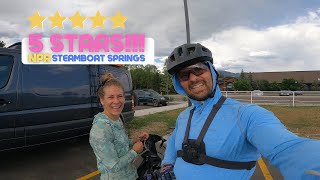
Jul 27, 2025 , Steamboat Springs
trail: Lower NPR - Blue
6:09 |
246 |
Jul 22, 2023 , Steamboat Springs

trail: NPR
6:09 |
178 |
Jul 22, 2023 , Steamboat Springs
trail: NPR
13:03 |
327 |
Jan 29, 2023 , Steamboat Springs
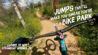
trail: Quarry Mountain
8:48 |
230 |
Dec 2, 2022 , Steamboat Springs

trail: NPR
8:48 |
185 |
Dec 2, 2022 , Steamboat Springs
Recent Trail Reports
| status | trail | date | condition | info | user |
|---|---|---|---|---|---|
| Lower NPR - Blue | May 29, 2026 @ 10:51am (America/Denver) May 29, 2026 | Dry | LosCheese | ||
| NPR | May 29, 2026 @ 10:51am (America/Denver) May 29, 2026 | Variable | LosCheese | ||
| Little Moab | May 29, 2026 @ 10:51am (America/Denver) May 29, 2026 | Dry | LosCheese | ||
| Lupine | May 29, 2026 @ 10:51am (America/Denver) May 29, 2026 | Variable | LosCheese | ||
| Lupine | May 29, 2026 @ 10:51am (America/Denver) May 29, 2026 | Variable | LosCheese | ||
| Wild Rose | May 14, 2026 @ 11:20am (America/Denver) May 14, 2026 | Variable | WillieJacobsz Trailforks | ||
| Steamboat Springs BMX Track | May 14, 2026 @ 11:20am (America/Denver) May 14, 2026 | Variable | WillieJacobsz Trailforks | ||
| Stairway to Heaven (Lower) | May 14, 2026 @ 11:20am (America/Denver) May 14, 2026 | Variable | WillieJacobsz Trailforks | ||
| Stairway To Heaven | May 14, 2026 @ 11:20am (America/Denver) May 14, 2026 | Variable | WillieJacobsz Trailforks | ||
| Root Canal | May 14, 2026 @ 11:20am (America/Denver) May 14, 2026 | Variable | WillieJacobsz Trailforks |
Activity Feed
| username | action | type | title | date |
|---|---|---|---|---|
| 22Lrek | ridden | trail | activity #97276866 and 16 more | Jun 18, 2026 @ 2:41pm 2 days |
| uphillarch | wishlist | route | activity #96844384 | Jun 12, 2026 @ 7:35pm Jun 12, 2026 |
| durflord69 | wishlist | trail | activity #96752427 | Jun 11, 2026 @ 11:44am Jun 11, 2026 |
| BlairgkrtKo | wishlist | trail | activity #96255012 and 1 more | Jun 4, 2026 @ 3:18pm Jun 4, 2026 |
| a-berm-loving-fern | wishlist | route | activity #96091756 | Jun 2, 2026 @ 9:55am Jun 2, 2026 |
Recent Comments
| username | type | title | comment | date |
|---|---|---|---|---|
| report | I | Sep 1, 2025 @ 9:37am Sep 1, 2025 | ||
| trail | The new gnar trail in steamboat! The upper... | Aug 18, 2025 @ 4:23pm Aug 18, 2025 | ||
| trail | Green trail. Please rerate! | Jul 16, 2024 @ 12:52pm Jul 16, 2024 | ||
| trail | Lotsa fun | Nov 12, 2023 @ 10:18pm Nov 12, 2023 | ||
| trail | This isn’t even close to a black. I’d call... | Sep 29, 2022 @ 7:06pm Sep 29, 2022 |
Nearby Areas
| name | distance | ||||
|---|---|---|---|---|---|
| In Town Trails | 6 | 1 | 0.5 km | ||
| Bear River Bike Park | 1 | 3 | 1 | 1 | 2.2 km |
| Backside Of Emerald Mountain | 2 | 3 | 2.9 km | ||
| Steamboat Bike Park | 6 | 10 | 3 | 3.2 km | |
| Mount Werner | 1 | 6 | 6 | 5.6 km |
Local Badges
-

Completionist0 awarded
Bike & Skill Parks
| name | type | city | rating |
|---|---|---|---|
| Steamboat Springs BMX Track | skill park | Steamboat Springs |
Local Products
Activity Type Stats
| activitytype | trails | distance | descent | descent distance | total vertical | rating | global rank | state rank | photos | reports | routes | ridelogs |
|---|---|---|---|---|---|---|---|---|---|---|---|---|
| Mountain Bike | 54 | 37 miles | 7,520 ft | 17 miles | 1,549 ft | #493 | #189 | 292 | 1,112 | 70 | 20,154 | |
| Gravel Bike | 14 | 12 miles | 866 ft | 2 miles | 1,545 ft | #23 | #24 | 320 | 90 | |||
| Horse | 1 | #2,735 | #1,539 | 556 | ||||||||
| Hike | 51 | 33 miles | 5,906 ft | 14 miles | 1,545 ft | #4,849 | #1,749 | 1,095 | 572 | |||
| Trail Running | 51 | 33 miles | 5,906 ft | 14 miles | 1,545 ft | #3,596 | #981 | 1,095 | 5 | 869 | ||
| Snowshoe | 1 | #1,119 | #563 | 17 | 10 | |||||||
| Backcountry Ski | 1 | #342 | #86 | 17 | 87 | |||||||
| Nordic Ski | 1 | #979 | #413 | 17 | 185 |
Frequently Asked Questions About Emerald Mountain
▼
What are the highest rated mountain biking trails in Emerald Mountain?
The highest rated mountain biking trails in Emerald Mountain are:
- NPR (4.6/5)
- Agate (4.5/5)
- Lower NPR - Blue (4.5/5)
- Abby's (4.4/5)
- Morning Gloria (4.4/5)
▼
What is the best time of the year to ride in Emerald Mountain?
Based on ride log data, the most popular months to ride in Emerald Mountain are:
- July (479 activities)
- August (265 activities)
- June (235 activities)
▼
Where can I park to ride in Emerald Mountain?
There are 2 parking locations listed in Emerald Mountain. The most popular parking spots are:
▼
What is the longest trail in Emerald Mountain?
The longest trail in Emerald Mountain is Morning Gloria at 3.9 miles. View all trails sorted by distance.
Activities
Trails
Points of Interest
- By brenthillier
 NSMBA TRAILFORKS & contributors
 - Admins: RCR, COSS, RCR, COSS, RCR
- #7959 - 22,331 views
- emerald mountain activity log | embed map of Emerald Mountain mountain bike trails | emerald mountain mountain biking points of interest polygons
Downloading of trail gps tracks in kml & gpx formats is enabled for Emerald Mountain.
You must login to download files.