close
-
Layers w
- Weather Layers
- Pro
- Pro
- Pro
- Pro
- Pro
- Pro
- More Layers
- Pro
- Pro
- Pro
- Pro
-
Upgrade to

3D
Trail Conditions
- Unknown
- Snow Groomed
- Snow Packed
- Snow Covered
- Snow Cover Partial
- Freeze/thaw Cycle
- Icy
- Prevalent Mud
- Wet
- Variable
- Ideal
- Dry
- Very Dry
Trail Flow (Ridden Direction)
Trailforks scans users ridelogs to determine the most popular direction each trail is ridden. A good flowing trail network will have most trails flowing in a single direction according to their intension.
The colour categories are based on what percentage of riders are riding a trail in its intended direction.
The colour categories are based on what percentage of riders are riding a trail in its intended direction.
- > 96%
- > 90%
- > 80%
- > 70%
- > 50%
- < 50%
- bi-directional trail
- no data
Trail Last Ridden
Trailforks scans ridelogs to determine the last time a trail was ridden.
- < 2 days
- < 1 week
- < 2 weeks
- < 1 month
- < 6 months
- > 6 months
Trail Ridden Direction
The intended direction a trail should be ridden.
- Downhill Only
- Downhill Primary
- Both Directions
- Uphill Primary
- Uphill Only
- One Direction
Contribute Details
Colors indicate trail is missing specified detail.
- Description
- Photos
- Description & Photos
- Videos
Trail Popularity ?
Trailforks scans ridelogs to determine which trails are ridden the most in the last 9 months.
Trails are compared with nearby trails in the same city region with a possible 25 colour shades.
Think of this as a heatmap, more rides = more kinetic energy = warmer colors.
- most popular
- popular
- less popular
- not popular
ATV/ORV/OHV Filter
Max Vehicle Width
inches
US Cell Coverage
Legend

Radar Time
Activity Recordings
Trailforks uses anonymized public activity data.
?
Activity Recordings
Trailforks uses anonymized public activity data.
?
Personal Heatmap
▶
Activity Types
all
/
none
▶
Options
2
Date range
month
–
Winter Trails
Warning
A routing network for winter maps does not exist. Selecting trails using the winter trails layer has been disabled.
Missing Trails
Most Popular
Least Popular
Trails are colored based on popularity. The more popular a trail is, the more red. Less popular trails trend towards green.
Jump Magnitude Heatmap
Heatmap of where riders jump on trails. Zoom in to see individual jumps, click circles to view jump details.
BC Backroad Status
![map legend]()
Service Road Atlas is a free to use, community-driven service for viewing and creating reports on the numerous back-country service roads around B.C. and Alberta.

Slope Aspect
Direction the slope faces
Trails Deemphasized
Trails are shown in grey.
Only show trails with no bike usage.
Suggested Layers
Based on selected activity type
Save the current map location and zoom level as your default home location whenever this page is loaded.
Save
No description for Enfield has been added yet!
Login or register to submit one.
Activities Click to view
- Mountain Bike
50 trails
- E-Bike
32 trails
- Gravel Bike
29 trails
- Adaptive Bike
0 trails
- Horse
32 trails
- Hike
50 trails
- Trail Running
50 trails
- Dirtbike/Moto
34 trails
- ATV/ORV/OHV
34 trails
- Snowmobile
32 trails
- Snowshoe
49 trails
- Backcountry Ski
25 trails
- Nordic Ski
36 trails
Region Details
- 36
- 2
- 4
- 5
- 3
Region Status
Open as of Jul 29, 2025Local Trail Association
Stats
- Avg Trail Rating
- Trails (view details)
- 50
- Trails Mountain Bike
- 50
- Trails E-Bike
- 32
- Trails Gravel Bike
- 29
- Trails Horse
- 32
- Trails Hike
- 50
- Trails Trail Running
- 50
- Trails Dirtbike/Moto
- 34
- Trails ATV/ORV/OHV
- 34
- Trails Snowmobile
- 32
- Trails Snowshoe
- 49
- Trails Backcountry Ski
- 25
- Trails Nordic Ski
- 36
- Total Distance
- 93 miles
- Total Descent
- 5,073 ft
- Total Vertical
- 557 ft
- Highest Trailhead
- 624 ft
- Reports
- 50
- Photos
- 35
- Ridden Counter
- 468
Sub Regions
-
Grant Road Trails
- 4
- 4
- 3
-
Renfrew Gold District
Popular Enfield Mountain Biking Trails
• 100 ★ 4.0 • 2,037 ft • 0 ft • 45 •
Popular black diamond difficulty singletrack. This multi-use trail can be used downhill primary. It features drop and rock face. On average it takes 4 minutes to complete this trail.
• 80 ★ 4.0 • 1,617 ft • 14 ft • 42 •
Popular blue difficulty singletrack. This multi-use trail can be used downhill primary. On average it takes 3 minutes to complete this trail.
• 80 ★ 4.0 • 863 ft • 0 ft • 39 •
Popular blue difficulty singletrack. This multi-use trail can be used downhill primary. It features bridge. On average it takes 1 minutes to complete this trail.
• 90 ★ 3.4 • 1,522 ft • 0 ft • 38 •
Popular black diamond difficulty singletrack. This multi-use trail can be used downhill only. It features a-frame. On average it takes 2 minutes to complete this trail.
• 90 ★ 3.5 • 2,595 ft • 38 ft • 36 •
Popular green difficulty singletrack. This multi-use trail can be used both directions with a 38 ft green climb. It features bridge. On average it takes 8 minutes to complete this trail.
• 5 ★ 2.0 • 2,346 ft • 4 ft • 34 •
Less popular blue difficulty singletrack. This multi-use trail can be used both directions. It features bridge. On average it takes 16 minutes to complete this trail.
• 5 ★ 0.0 • 341 ft • 22 ft • 8 •
Less popular blue difficulty singletrack. This multi-use trail can be used both directions and has a moderate overall physical rating with a 22 ft blue climb. Trail visibility is always easy to follow. On average it takes 1 minutes to complete this trail.
• 5 ★ 0.0 • 449 ft • 0 ft • 6 •
Less popular green difficulty singletrack. This multi-use trail can be used both directions. On average it takes minutes to complete this trail.
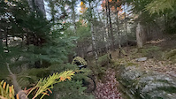
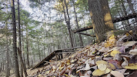
Photos of Enfield Mountain Bike
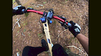
Videos of Enfield Mountain Bike
0:12 |
55 |
Oct 26, 2025
0:16 |
48 |
Oct 25, 2025
trail: Deer Leg
3:00 |
239 |
Sep 27, 2019

trail: Ridge 2 Bridge
0:07 |
258 |
Oct 4, 2021 , Enfield
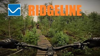
trail: Ridgeline
3:07 |
284 |
Oct 4, 2021 , Enfield
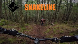
trail: Snakeline
0:47 |
403 |
Oct 4, 2021 , Enfield
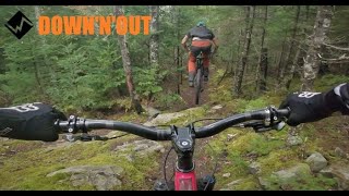
trail: Down & Out
2:16 |
345 |
Oct 4, 2021 , Enfield
Recent Trail Reports
| status | trail | date | condition | info | user |
|---|---|---|---|---|---|
| Down & Out | Jul 29, 2025 @ 11:40am Jul 29, 2025 | Dry | EricMB | ||
| Ridge 2 Bridge | Jul 29, 2025 @ 11:40am Jul 29, 2025 | Dry | EricMB | ||
| Ridgeline | Apr 3, 2023 @ 10:55pm Apr 3, 2023 | Ideal | Jonnief | ||
| Snakeline | Apr 3, 2023 @ 10:55pm Apr 3, 2023 | Ideal | Jonnief | ||
| Deer Leg connector | Apr 3, 2023 @ 10:55pm Apr 3, 2023 | Ideal | Jonnief | ||
| Deer Leg | Apr 3, 2023 @ 10:55pm Apr 3, 2023 | Ideal | Jonnief | ||
| Riverside | Apr 3, 2023 @ 10:55pm Apr 3, 2023 | Ideal | Jonnief | ||
| Deer Leg Extension | Apr 4, 2023 @ 5:55am Apr 4, 2023 | Ideal | Jonnief | ||
| Wood Road | May 1, 2020 @ 2:57pm May 1, 2020 | Unknown | bent6543 TRAILFORKS | ||
| Riverside Connector | May 1, 2020 @ 2:57pm May 1, 2020 | Unknown | bent6543 TRAILFORKS |
Activity Feed
| username | action | type | title | date |
|---|---|---|---|---|
| ElliotP7 | add | photo | activity #95210210 | May 21, 2026 @ 5:06pm May 21, 2026 |
| bent6543 | add | poi | activity #94423099 | May 10, 2026 @ 7:03am May 10, 2026 |
| bent6543 | add | trail | activity #94422665 | May 10, 2026 @ 6:58am May 10, 2026 |
| paddman | wishlist | trail | activity #91811187 | Apr 3, 2026 @ 4:09am Apr 3, 2026 |
| Scott5CbsF8 | comment | trail | activity #83462389 | Nov 2, 2025 @ 11:04am Nov 2, 2025 |
Recent Comments
| username | type | title | comment | date |
|---|---|---|---|---|
| trail | Rode 2nd November; trail is overgrown, bridges... | Nov 2, 2025 @ 11:04am Nov 2, 2025 | ||
| trail | Can't say for sure but it is a popular atv... | Mar 29, 2025 @ 2:42pm Mar 29, 2025 | ||
| trail | Is this trail still accessible from Kenrick... | Mar 29, 2025 @ 1:20pm Mar 29, 2025 | ||
| trail | Great trail. Whoever worked on it did a great... | Jun 22, 2024 @ 8:06am Jun 22, 2024 | ||
| trail | Great tech climb trail. Cool for the downhill too. | Jun 22, 2024 @ 8:05am Jun 22, 2024 |
Local Badges
-

Epic Ride Climb 2k0 awarded -

Climbing 10k Badge1 awarded -

Climbing 100k Badge0 awarded -

Epic Ride Descent 2k0 awarded -

Descent 10k Badge1 awarded -

Descent 100k Badge0 awarded
Activity Type Stats
| activitytype | trails | distance | descent | descent distance | total vertical | rating | global rank | state rank | photos | reports | routes | ridelogs |
|---|---|---|---|---|---|---|---|---|---|---|---|---|
| Mountain Bike | 50 | 93 miles | 5,072 ft | 42 miles | 558 ft | #4,049 | #13 | 35 | 50 | 613 | ||
| E-Bike | 32 | 86 miles | 4,147 ft | 39 miles | 558 ft | #2,410 | #4 | 15 | 42 | |||
| Gravel Bike | 29 | #574 | #16 | 3 | ||||||||
| Horse | 32 | 87 miles | 4,173 ft | 39 miles | 558 ft | #833 | #4 | 5 | 1 | |||
| Hike | 50 | 93 miles | 5,072 ft | 42 miles | 558 ft | #3,457 | #8 | 50 | 148 | |||
| Trail Running | 50 | 93 miles | 5,072 ft | 42 miles | 558 ft | #2,943 | #7 | 50 | 6 | |||
| Dirtbike/Moto | 34 | 88 miles | 4,285 ft | 39 miles | 558 ft | #557 | #3 | 5 | 14 | |||
| ATV/ORV/OHV | 34 | 88 miles | 4,386 ft | 40 miles | 558 ft | #389 | #3 | 5 | 9 | |||
| Snowmobile | 32 | 87 miles | 4,173 ft | 39 miles | 558 ft | #167 | #2 | |||||
| Snowshoe | 49 | 93 miles | 5,072 ft | 42 miles | 558 ft | #340 | #5 | 8 | 5 | |||
| Backcountry Ski | 25 | 69 miles | 2,923 ft | 29 miles | 551 ft | #379 | #1 | |||||
| Nordic Ski | 36 | 88 miles | 4,308 ft | 40 miles | 558 ft | #425 | #3 | 5 |
Frequently Asked Questions About Enfield
▼
What are the best places to ride in Enfield?
Enfield has 2 areas to explore for mountain biking. The top rated areas are:
▼
What are the highest rated mountain biking trails in Enfield?
The highest rated mountain biking trails in Enfield are:
- Down & Out (4/5)
- Ridgeline (4/5)
- Ridge 2 Bridge (4/5)
- Deer Leg (3.9/5)
- Snakeline (3.7/5)
▼
What is the best time of the year to ride in Enfield?
Based on ride log data, the most popular months to ride in Enfield are:
- September (9 activities)
- May (8 activities)
- August (4 activities)
▼
Where can I park to ride in Enfield?
Activities
- Enfield Mountain Biking Trails
- Enfield E-Biking Trails
- Enfield Gravel Biking Trails
- Enfield Horseback Trails
- Enfield Hiking Trails
- Enfield Trail Running Trails
- Enfield Dirtbiking Trails
- Enfield ATVing/Offroading Trails
- Enfield Snowmobiling Trails
- Enfield Snowshoeing Trails
- Enfield Backcountry Skiing Trails
- Enfield Nordic Skiing Trails
- By BornAgainKen & contributors
- Admins: bent6543
- #4449 - 5,017 views
- enfield activity log | embed map of Enfield mountain bike trails | enfield mountain biking points of interest polygons
Downloading of trail gps tracks in kml & gpx formats is enabled for Enfield.
You must login to download files.