close
-
Layers w
- Weather Layers
- Pro
- Pro
- Pro
- Pro
- Pro
- Pro
- More Layers
- Pro
- Pro
- Pro
- Pro
-
Upgrade to

3D
Trail Conditions
- Unknown
- Snow Groomed
- Snow Packed
- Snow Covered
- Snow Cover Partial
- Freeze/thaw Cycle
- Icy
- Prevalent Mud
- Wet
- Variable
- Ideal
- Dry
- Very Dry
Trail Flow (Ridden Direction)
Trailforks scans users ridelogs to determine the most popular direction each trail is ridden. A good flowing trail network will have most trails flowing in a single direction according to their intension.
The colour categories are based on what percentage of riders are riding a trail in its intended direction.
The colour categories are based on what percentage of riders are riding a trail in its intended direction.
- > 96%
- > 90%
- > 80%
- > 70%
- > 50%
- < 50%
- bi-directional trail
- no data
Trail Last Ridden
Trailforks scans ridelogs to determine the last time a trail was ridden.
- < 2 days
- < 1 week
- < 2 weeks
- < 1 month
- < 6 months
- > 6 months
Trail Ridden Direction
The intended direction a trail should be ridden.
- Downhill Only
- Downhill Primary
- Both Directions
- Uphill Primary
- Uphill Only
- One Direction
Contribute Details
Colors indicate trail is missing specified detail.
- Description
- Photos
- Description & Photos
- Videos
Trail Popularity ?
Trailforks scans ridelogs to determine which trails are ridden the most in the last 9 months.
Trails are compared with nearby trails in the same city region with a possible 25 colour shades.
Think of this as a heatmap, more rides = more kinetic energy = warmer colors.
- most popular
- popular
- less popular
- not popular
ATV/ORV/OHV Filter
Max Vehicle Width
inches
US Cell Coverage
Legend

Radar Time
Activity Recordings
Trailforks uses anonymized public activity data.
?
Activity Recordings
Trailforks uses anonymized public activity data.
?
Personal Heatmap
▶
Activity Types
all
/
none
▶
Options
2
Date range
month
–
Winter Trails
Warning
A routing network for winter maps does not exist. Selecting trails using the winter trails layer has been disabled.
Missing Trails
Most Popular
Least Popular
Trails are colored based on popularity. The more popular a trail is, the more red. Less popular trails trend towards green.
Jump Magnitude Heatmap
Heatmap of where riders jump on trails. Zoom in to see individual jumps, click circles to view jump details.
BC Backroad Status
![map legend]()
Service Road Atlas is a free to use, community-driven service for viewing and creating reports on the numerous back-country service roads around B.C. and Alberta.

Slope Aspect
Direction the slope faces
Trails Deemphasized
Trails are shown in grey.
Only show trails with no bike usage.
Suggested Layers
Based on selected activity type
Save the current map location and zoom level as your default home location whenever this page is loaded.
Save
No description for Equi Terme has been added yet!
Login or register to submit one.
This region uses the Uk/Euro style trail grading system.
Activities Click to view
- Mountain Bike
12 trails
- E-Bike
11 trails
- Adaptive Bike
0 trails
- Horse
7 trails
- Hike
9 trails
- Trail Running
7 trails
Region Details
- 6
- 1
- 2
- 3
Region Status
Caution as of Aug 11, 2025Stats
- Avg Trail Rating
- Trails (view details)
- 12
- Trails Mountain Bike
- 12
- Trails E-Bike
- 11
- Trails Horse
- 7
- Trails Hike
- 9
- Trails Trail Running
- 7
- Total Distance
- 16 miles
- Total Descent Distance
- 6 miles
- Total Descent
- 4,547 ft
- Total Vertical
- 2,726 ft
- Highest Trailhead
- 3,387 ft
- Reports
- 50
- Photos
- 1
- Ridden Counter
- 257
Popular Equi Terme Mountain Biking Trails
• 100 ★ 4.5 • 3,740 ft • 0 ft • 27 •
Popular blue difficulty singletrack. This mountain bike primary trail can be used both directions. On average it takes 5 minutes to complete this trail.
• 95 ★ 4.0 • 2,963 ft • 6 ft • 23 •
Trail di collegamento tra Mezzana ed Equi T. Lasciamo la strada asfaltata in prossimità del guard rail sulla nostra destra e scendiamo repentinamente su una via carrareccia che entra fra campi coltivati ed ulivi. Dopo aver attraversato...
• 60 ★ 0.0 • 3,245 ft • 0 ft • 15 •
Trail verticale e guidato. Sviluppo spesso tecnico e mai banale. Alcuni passaggi da affrontare con attenzione e prudenza, soprattutto se non esperti. Divertente ed adrenalinico soprattutto nella seconda parte. Se bagnato, scendere con...
• 5 ★ 4.0 • 2 miles • 251 ft • 6 •
Trail di collegamento tra la fine del trail ed il paese di Gragnola. Il tracciato può essere percorso in entrambe le direzioni, presentando uno sviluppo piuttosto omogeneo sui due lati. Ideale per gli appassionati di XC, poiché...
• 35 ★ 3.0 • 1 mile • 2 ft • 1 •
Less popular red difficulty alpine singletrack. This mountain bike primary trail can be used downhill only. Trail visibility is always easy to follow.
Equi Terme Mountain Bike Routes
13 miles • 3,358 ft • 5 • Loop •
Percorso 32 della lunigiana https://lunigianabikearea.com/percorso-32-anello-rosso/ link per le informazioni
Photos of Equi Terme Mountain Bike
Videos of Equi Terme Mountain Bike

trail: Cinghio Verticale
11:21 |
141 |
Apr 21, 2024 , Equi Terme
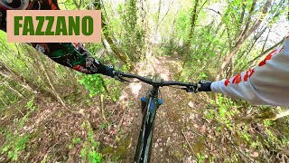
trail: Fazzano Trail
7:54 |
127 |
Apr 21, 2024 , Equi Terme
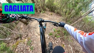
trail: Gagliata
11:38 |
137 |
Apr 20, 2024 , Equi Terme
Recent Trail Reports
| status | trail | date | condition | info | user |
|---|---|---|---|---|---|
| Collegamento Fazzano Trail- Gagliata-Cinghio Verticale | Aug 11, 2025 @ 2:15pm Aug 11, 2025 | Ideal | ZioBilly79 | ||
| Fazzano Trail | Aug 11, 2025 @ 2:15pm Aug 11, 2025 | Ideal | ZioBilly79 | ||
| Risalita Mezzana-Fazzano | Aug 11, 2025 @ 2:15pm Aug 11, 2025 | Dry | ZioBilly79 | ||
| Risalita HardTrail Pago-Fazzano | Jun 1, 2025 @ 11:04am Jun 1, 2025 | Variable | flasub | ||
| Gagliata | May 10, 2025 @ 7:14am May 10, 2025 | Wet | Albe79 | ||
| Cinghio Verticale | May 10, 2025 @ 7:13am May 10, 2025 | Dry | Albe79 | ||
| Ippovia Equi T. - Casciana | May 10, 2025 @ 7:07am May 10, 2025 | Unknown | Albe79 | ||
| Sent. 40 - Accesso alla 2°parte dell' Odissea | May 25, 2024 @ 11:43pm May 25, 2024 | Variable | boicmtb | ||
| Trail La Molina | Apr 20, 2024 @ 3:42am Apr 20, 2024 | Variable | Ilcannibale | ||
| Risalita Tecnica Equi T.-Aiola | Sep 30, 2023 @ 2:00am Sep 30, 2023 | Ideal | Axcel77 |
Activity Feed
| username | action | type | title | date |
|---|---|---|---|---|
| Simon0405 | ridden | trail | activity #89673300 and 1 more | Feb 28, 2026 @ 1:31am Feb 28, 2026 |
| 99Cello99 | wishlist | trail | activity #79673966 and 2 more | Sep 5, 2025 @ 4:00am Sep 5, 2025 |
| ZioBilly79 | add | report | activity #77922758 and 2 more | Aug 11, 2025 @ 12:43pm Aug 11, 2025 |
| Albe79 | comment | trail | activity #73321461 | Jun 8, 2025 @ 12:38am Jun 8, 2025 |
| flasub | add | report | activity #72844851 and 2 more | Jun 1, 2025 @ 4:42am Jun 1, 2025 |
Recent Comments
| username | type | title | comment | date |
|---|---|---|---|---|
| trail | Mortale, soprattutto fatta a fine giro. Ti fa... | Jun 8, 2025 @ 12:38am Jun 8, 2025 | ||
| trail | Bel single track selvaggio, scorrevole a... | May 10, 2025 @ 7:12am May 10, 2025 | ||
| trail | Please post as a “trail report”. this area... | Jun 23, 2024 @ 12:42pm Jun 23, 2024 | ||
| trail | We could not get on the trail, the entrance... | Jun 23, 2024 @ 1:17am Jun 23, 2024 | ||
| trail | In Buone condizioni | Nov 10, 2022 @ 6:16am Nov 10, 2022 |
Local Badges
-

Epic Mountain Bike Climb 2k12 awarded -

Climbing 10k Badge1 awarded -

Mountain Biking 100k Badge0 awarded -

Epic Ride Descent 2k12 awarded -

Descent 10k Badge1 awarded -

Descent 100k Badge0 awarded
Activity Type Stats
| activitytype | trails | distance | descent | descent distance | total vertical | rating | global rank | state rank | photos | reports | routes | ridelogs |
|---|---|---|---|---|---|---|---|---|---|---|---|---|
| Mountain Bike | 12 | 16 miles | 4,547 ft | 6 miles | 2,726 ft | #8,304 | #746 | 1 | 50 | 1 | 308 | |
| E-Bike | 11 | 15 miles | 3,825 ft | 5 miles | 2,726 ft | #5,705 | #566 | 47 | 14 | |||
| Horse | 7 | 10 miles | 1,014 ft | 2 miles | 2,726 ft | #2,271 | #149 | 3 | ||||
| Hike | 9 | 14 miles | 2,244 ft | 4 miles | 2,726 ft | #9,258 | #606 | 37 | 41 | |||
| Trail Running | 7 | 12 miles | 1,142 ft | 3 miles | 2,726 ft | #9,291 | #653 | 34 |
Frequently Asked Questions About Equi Terme
▼
What are the highest rated mountain biking trails in Equi Terme?
The highest rated mountain biking trails in Equi Terme are:
- Gagliata (4.1/5)
- Fazzano Trail (4.1/5)
- Trail La Molina (4/5)
- Il Pago (4/5)
- Ugliancaldo DH (CAI 176) (3.8/5)
▼
What is the best time of the year to ride in Equi Terme?
Based on ride log data, the most popular months to ride in Equi Terme are:
- February (2 activities)
- May (2 activities)
- July (2 activities)
▼
Where can I park to ride in Equi Terme?
Check the Equi Terme trail map for trailhead and parking information. Community members regularly update access and parking details for trails in the area.
▼
What is the longest trail in Equi Terme?
The longest trail in Equi Terme is Il Pago at 1.8 miles. View all trails sorted by distance.
Activities
Trails
Points of Interest
- By singlespeedissimo
 WCT & contributors
 - Admins: DanielePracchia, WCT
- #41244 - 1,159 views
- equi terme activity log | embed map of Equi Terme mountain bike trails |
Downloading of trail gps tracks in kml & gpx formats is enabled for Equi Terme.
You must login to download files.