close
-
Layers w
- Weather Layers
- Pro
- Pro
- Pro
- Pro
- Pro
- Pro
- More Layers
- Pro
- Pro
- Pro
- Pro
-
Upgrade to

3D
Trail Conditions
- Unknown
- Snow Groomed
- Snow Packed
- Snow Covered
- Snow Cover Partial
- Freeze/thaw Cycle
- Icy
- Prevalent Mud
- Wet
- Variable
- Ideal
- Dry
- Very Dry
Trail Flow (Ridden Direction)
Trailforks scans users ridelogs to determine the most popular direction each trail is ridden. A good flowing trail network will have most trails flowing in a single direction according to their intension.
The colour categories are based on what percentage of riders are riding a trail in its intended direction.
The colour categories are based on what percentage of riders are riding a trail in its intended direction.
- > 96%
- > 90%
- > 80%
- > 70%
- > 50%
- < 50%
- bi-directional trail
- no data
Trail Last Ridden
Trailforks scans ridelogs to determine the last time a trail was ridden.
- < 2 days
- < 1 week
- < 2 weeks
- < 1 month
- < 6 months
- > 6 months
Trail Ridden Direction
The intended direction a trail should be ridden.
- Downhill Only
- Downhill Primary
- Both Directions
- Uphill Primary
- Uphill Only
- One Direction
Contribute Details
Colors indicate trail is missing specified detail.
- Description
- Photos
- Description & Photos
- Videos
Trail Popularity ?
Trailforks scans ridelogs to determine which trails are ridden the most in the last 9 months.
Trails are compared with nearby trails in the same city region with a possible 25 colour shades.
Think of this as a heatmap, more rides = more kinetic energy = warmer colors.
- most popular
- popular
- less popular
- not popular
ATV/ORV/OHV Filter
Max Vehicle Width
inches
US Cell Coverage
Legend

Radar Time
Activity Recordings
Trailforks uses anonymized public activity data.
?
Activity Recordings
Trailforks uses anonymized public activity data.
?
Personal Heatmap
▶
Activity Types
all
/
none
▶
Options
2
Date range
month
–
Winter Trails
Warning
A routing network for winter maps does not exist. Selecting trails using the winter trails layer has been disabled.
Missing Trails
Most Popular
Least Popular
Trails are colored based on popularity. The more popular a trail is, the more red. Less popular trails trend towards green.
Jump Magnitude Heatmap
Heatmap of where riders jump on trails. Zoom in to see individual jumps, click circles to view jump details.
BC Backroad Status
![map legend]()
Service Road Atlas is a free to use, community-driven service for viewing and creating reports on the numerous back-country service roads around B.C. and Alberta.

Slope Aspect
Direction the slope faces
Trails Deemphasized
Trails are shown in grey.
Only show trails with no bike usage.
Suggested Layers
Based on selected activity type
Save the current map location and zoom level as your default home location whenever this page is loaded.
Save
No description for Evergreen has been added yet!
Login or register to submit one.
Activities Click to view
- Mountain Bike
75 trails
- E-Bike
67 trails
- Gravel Bike
0 trails
- Adaptive Bike
0 trails
- Winter Fat Bike
0 trails
- Hike
79 trails
- Trail Running
79 trails
Region Details
- 8
- 2
- 25
- 23
- 9
- 1
Region Status
Open as of 2 daysStats
- Avg Trail Rating
- Trails (view details)
- 69
- Trails Mountain Bike
- 76
- Trails E-Bike
- 67
- Trails Horse
- 1
- Trails Hike
- 79
- Trails Trail Running
- 79
- Total Distance
- 57 miles
- Total Descent
- 11,054 ft
- Total Vertical
- 2,963 ft
- Highest Trailhead
- 10,051 ft
- Reports
- 785
- Photos
- 124
- Ridden Counter
- 41,014
Sub Regions
-
Alderfer Three Sisters Park
- 10
- 18
- 3
-
Elk Meadow Park
- 2
- 11
- 2
- 2
-
Maxwell Falls
- 2
- 1
- 2
- 1
Popular Evergreen Mountain Biking Trails
• 100 ★ 2.5 • 1,537 ft • 83 ft • 1,733 •
Popular blue difficulty singletrack. This multi-use trail can be used both directions. On average it takes 3 minutes to complete this trail.
• 95 ★ 4.2 • 2 miles • 60 ft • 1,613 •
Highly rated popular blue difficulty singletrack. This multi-use trail can be used both directions and has a moderate overall physical rating with a 60 ft blue climb. On average it takes 11 minutes to complete this trail.
• 100 ★ 4.5 • 3,402 ft • 27 ft • 1,553 •
Popular blue difficulty singletrack. This multi-use trail can be used both directions and has a moderate overall physical rating with a 27 ft blue climb. On average it takes 4 minutes to complete this trail.
• 90 ★ 4.0 • 5,068 ft • 3 ft • 1,475 •
Popular blue difficulty singletrack. This multi-use trail can be used both directions and has a moderate overall physical rating with a 3 ft blue climb. On average it takes 6 minutes to complete this trail.
• 95 ★ 4.0 • 2,405 ft • 70 ft • 1,463 •
Popular blue difficulty singletrack. This multi-use trail can be used both directions and has a moderate overall physical rating with a 70 ft blue climb. On average it takes 11 minutes to complete this trail.
• 100 ★ 3.7 • 1,454 ft • 50 ft • 1,370 •
Popular blue difficulty singletrack. This multi-use trail can be used both directions and has a easy overall physical rating with a 50 ft blue climb. On average it takes 2 minutes to complete this trail.
• 95 ★ 0.0 • 801 ft • 74 ft • 1,310 •
Popular blue difficulty singletrack. This multi-use trail can be used both directions and has a moderate overall physical rating with a 74 ft blue climb. On average it takes 2 minutes to complete this trail.
• 35 ★ 2.0 • 400 ft • 21 ft • 1,234 •
Less popular green difficulty singletrack. This multi-use trail can be used both directions. On average it takes 1 minutes to complete this trail.
Evergreen Mountain Bike Routes
★ 5.0 • 38 miles • 6,920 ft • 19 • Loop •
A stellar way to ride Staunton SP with the added bonus of climbing over the shoulder of Black Mtn. The...
20 miles • 3,702 ft • 2 • Out & Back •
Physical tester on the old school climb from into the north side of Staunton State Park for an extremely...
★ 5.0 • 13 miles • 2,207 ft • 17 • Loop •
This is a good route if you want to avoid the most technical stuff but still want some spice in your life...
★ 5.0 • 14 miles • 2,448 ft • 26 • Point to Point •
Long ride/run starting at Wilmot Trail. The goal is to get in a 15 mile run/ride with minimal backtracking.
★ 5.0 • 4 miles • 820 ft • 1 •
Photos of Evergreen Mountain Bike
Videos of Evergreen Mountain Bike
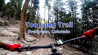
trail: Too Long
4:14 |
299 |
Dec 26, 2019
trail: Wild Iris Loop
6:45 |
121 |
May 15, 2016
trail: Sisters
5:11 |
631 |
Sep 14, 2014

trail: Summit
0:45 |
2239 |
Sep 4, 2013
trail: Summit
0:54 |
203 |
Oct 28, 2012
trail: Sisters
3:43 |
130 |
Feb 21, 2012
trail: Sisters
2:43 |
144 |
Jan 28, 2025 , Evergreen
trail: Ponderosa
5:42 |
105 |
Jan 26, 2025 , Evergreen
Recent Trail Reports
| status | trail | date | condition | info | user |
|---|---|---|---|---|---|
| Dedisse | Jun 17, 2026 @ 5:13pm (America/Denver) 2 days | Dry | 12runner1212 | ||
| Sisters | Jun 17, 2026 @ 5:13pm (America/Denver) 2 days | Dry | 12runner1212 | ||
| Sisters | Jun 17, 2026 @ 5:13pm (America/Denver) 2 days | Dry | 12runner1212 | ||
| Ponderosa | Jun 17, 2026 @ 5:13pm (America/Denver) 2 days | Dry | 12runner1212 | ||
| Ponderosa | Jun 17, 2026 @ 5:13pm (America/Denver) 2 days | Dry | 12runner1212 | ||
| Evergreen Mountain West | Jun 17, 2026 @ 5:13pm (America/Denver) 2 days | Dry | 12runner1212 | ||
| Summit | Jun 17, 2026 @ 5:13pm (America/Denver) 2 days | Dry | 12runner1212 | ||
| Summit Loop | Jun 17, 2026 @ 5:13pm (America/Denver) 2 days | Dry | 12runner1212 | ||
| Evergreen Mountain East | Jun 17, 2026 @ 5:13pm (America/Denver) 2 days | Dry | 12runner1212 | ||
| Evergreen Access | Jun 17, 2026 @ 5:13pm (America/Denver) 2 days | Dry | 12runner1212 |
Activity Feed
| username | action | type | title | date |
|---|---|---|---|---|
| 12runner1212 | add | report | activity #97228066 and 11 more | Jun 17, 2026 @ 7:55pm 2 days |
| rustymay | wishlist | route | activity #97180676 | Jun 17, 2026 @ 7:04am 3 days |
| rustymay | wishlist | route | activity #97179880 | Jun 17, 2026 @ 6:50am 3 days |
| calypso423 | wishlist | trail | activity #97042958 | Jun 15, 2026 @ 8:25am Jun 15, 2026 |
| bradwilks | wishlist | route | activity #96989593 | Jun 14, 2026 @ 11:24am Jun 14, 2026 |
Recent Comments
| username | type | title | comment | date |
|---|---|---|---|---|
| trail | Jensen peak trail closed until the end of June... | Jun 7, 2026 @ 7:35am Jun 7, 2026 | ||
| trail | Fun ride and pretty spot, worth the ride and... | May 10, 2026 @ 6:43pm May 10, 2026 | ||
| trail | They are not allowed at Cub Creek as its... | Apr 23, 2026 @ 1:30pm Apr 23, 2026 | ||
| report | The trail is split into two sections because... | Apr 5, 2026 @ 6:40am Apr 5, 2026 | ||
| report | How bad is it, are the other sections still... | Apr 5, 2026 @ 2:45am Apr 5, 2026 |
Local Badges
-

10 Green Trails200 awarded -

10 Blue Trails716 awarded -

Epic Ride Climb 2k320 awarded -

Climbing 10k Badge170 awarded -

Climbing 100k Badge2 awarded -

Epic Ride Descent 2k332 awarded
Activity Type Stats
| activitytype | trails | distance | descent | descent distance | total vertical | rating | global rank | state rank | photos | reports | routes | ridelogs |
|---|---|---|---|---|---|---|---|---|---|---|---|---|
| Mountain Bike | 75 | 56 miles | 11,050 ft | 28 miles | 2,963 ft | #899 | #353 | 117 | 812 | 18 | 22,718 | |
| E-Bike | 67 | 40 miles | 8,832 ft | 22 miles | 2,146 ft | #2,808 | #1,076 | 4 | 796 | 1 | 848 | |
| Horse | 1 | 191 | 1 | |||||||||
| Hike | 79 | 57 miles | 11,053 ft | 28 miles | 2,963 ft | #3,279 | #1,155 | 6 | 811 | 8 | 2,557 | |
| Trail Running | 79 | 57 miles | 11,053 ft | 28 miles | 2,963 ft | #3,086 | #900 | 811 | 8 | 1,298 |
Frequently Asked Questions About Evergreen
▼
What are the best places to ride in Evergreen?
Evergreen has 3 areas to explore for mountain biking. The top rated areas are:
▼
What are the highest rated mountain biking trails in Evergreen?
The highest rated mountain biking trails in Evergreen are:
- Summit (4.2/5)
- Sisters (4.2/5)
- Ponderosa (4.1/5)
- Meadow View (4.1/5)
- Meadow View (4.1/5)
▼
What is the best time of the year to ride in Evergreen?
Based on ride log data, the most popular months to ride in Evergreen are:
- July (252 activities)
- June (225 activities)
- August (198 activities)
▼
Where can I park to ride in Evergreen?
There are 12 parking locations listed in Evergreen. The most popular parking spots are: View all parking and trailhead locations on the map to plan your visit.
Activities
Trails
- By canadaka
 Trailforks & contributors
 - Admins: apply
- #4923 - 11,975 views
- evergreen activity log | embed map of Evergreen mountain bike trails | evergreen mountain biking points of interest
Downloading of trail gps tracks in kml & gpx formats is enabled for Evergreen.
You must login to download files.