close
-
Layers w
- Weather Layers
- Pro
- Pro
- Pro
- Pro
- Pro
- Pro
- More Layers
- Pro
- Pro
- Pro
- Pro
-
Upgrade to

3D
Trail Conditions
- Unknown
- Snow Groomed
- Snow Packed
- Snow Covered
- Snow Cover Partial
- Freeze/thaw Cycle
- Icy
- Prevalent Mud
- Wet
- Variable
- Ideal
- Dry
- Very Dry
Trail Flow (Ridden Direction)
Trailforks scans users ridelogs to determine the most popular direction each trail is ridden. A good flowing trail network will have most trails flowing in a single direction according to their intension.
The colour categories are based on what percentage of riders are riding a trail in its intended direction.
The colour categories are based on what percentage of riders are riding a trail in its intended direction.
- > 96%
- > 90%
- > 80%
- > 70%
- > 50%
- < 50%
- bi-directional trail
- no data
Trail Last Ridden
Trailforks scans ridelogs to determine the last time a trail was ridden.
- < 2 days
- < 1 week
- < 2 weeks
- < 1 month
- < 6 months
- > 6 months
Trail Ridden Direction
The intended direction a trail should be ridden.
- Downhill Only
- Downhill Primary
- Both Directions
- Uphill Primary
- Uphill Only
- One Direction
Contribute Details
Colors indicate trail is missing specified detail.
- Description
- Photos
- Description & Photos
- Videos
Trail Popularity ?
Trailforks scans ridelogs to determine which trails are ridden the most in the last 9 months.
Trails are compared with nearby trails in the same city region with a possible 25 colour shades.
Think of this as a heatmap, more rides = more kinetic energy = warmer colors.
- most popular
- popular
- less popular
- not popular
ATV/ORV/OHV Filter
Max Vehicle Width
inches
US Cell Coverage
Legend

Radar Time
Activity Recordings
Trailforks uses anonymized public activity data.
?
Activity Recordings
Trailforks uses anonymized public activity data.
?
Personal Heatmap
▶
Activity Types
all
/
none
▶
Options
2
Date range
month
–
Winter Trails
Warning
A routing network for winter maps does not exist. Selecting trails using the winter trails layer has been disabled.
Missing Trails
Most Popular
Least Popular
Trails are colored based on popularity. The more popular a trail is, the more red. Less popular trails trend towards green.
Jump Magnitude Heatmap
Heatmap of where riders jump on trails. Zoom in to see individual jumps, click circles to view jump details.
BC Backroad Status
![map legend]()
Service Road Atlas is a free to use, community-driven service for viewing and creating reports on the numerous back-country service roads around B.C. and Alberta.

Slope Aspect
Direction the slope faces
Trails Deemphasized
Trails are shown in grey.
Only show trails with no bike usage.
Suggested Layers
Based on selected activity type
Save the current map location and zoom level as your default home location whenever this page is loaded.
Save
No description for Ewen Maddock Dam has been added yet!
Login or register to submit one.
 google parking directions
Primary Trail Type: Cross-Country
Land Status: Regional Recreation Area
google parking directions Access Info:
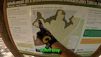
Ewen Maddock Dam, Maddock Park, Mooloolah Connection Road, Landsborough QLD 4550
Links
Activities Click to view
- Mountain Bike
8 trails
- E-Bike
9 trails
- Hike
9 trails
- Trail Running
9 trails
Region Details
- 4
- 4
Region Status
Caution as of May 15, 2026Stats
- Avg Trail Rating
- Trails (view details)
- 8
- Trails Mountain Bike
- 9
- Trails E-Bike
- 9
- Trails Hike
- 9
- Trails Trail Running
- 9
- Total Distance
- 14 miles
- Total Descent Distance
- 6 miles
- Total Descent
- 909 ft
- Total Vertical
- 194 ft
- Highest Trailhead
- 276 ft
- Reports
- 397
- Photos
- 159
- Ridden Counter
- 3,324
Popular Ewen Maddock Dam Mountain Biking Trails
• 100 ★ 4.6 • 6 miles • 335 ft • 934 •
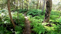
The Ferny Forest trails have been designed with the beginning mountain biker in mind. As the name suggests this circuit will take you through the beautiful forest that makes up the shoreline of the Ewen Maddock dam. There is a little...
• 100 ★ 5.0 • 2,451 ft • 46 ft • 854 •
Popular green difficulty singletrack. This mountain bike primary trail can be used both directions. On average it takes 4 minutes to complete this trail.
• 95 ★ 4.0 • 791 ft • 0 ft • 351 •
Popular green difficulty singletrack. This mountain bike primary trail can be used both directions and has a easy overall physical rating with a 0 ft green climb. On average it takes minutes to complete this trail.
• 95 ★ 0.0 • 463 ft • 9 ft • 314 •
Popular green difficulty singletrack. This mountain bike primary trail can be used both directions and has a easy overall physical rating with a 9 ft green climb. On average it takes minutes to complete this trail.
• 45 ★ 4.0 • 6 miles • 315 ft • 128 •
The is a wide gravel path that generally follows the waters edge from the carpark at Glenview around to the township of Landsborough. It is a shared trail used by birdwatchers, walkers, trail runners, horse rides and mountain bikers....
• 45 ★ 3.7 • 4,068 ft • 132 ft • 126 •
This hill is an optional extra you can do when traveling along the relatively flat main trail. It can be done in either direction.
• 55 ★ 1.4 • 5,253 ft • 30 ft • 126 •
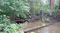
Warning - involves a slippery log creek crossing and the trail isn't well defined.
Ewen Maddock Dam Mountain Bike Routes
★ 3.0 • 12 miles • 755 ft • 3 • Loop •
This route makes use of foot/cycle paths to reduce overall distance and elevation. Ignore the elevation...
18 miles • 986 ft • 3 • Out & Back •
We start in Maddock Park near the dam then we travel through the dam trails, onto the roads through...
14 miles • 730 ft • 4 • Loop •
Another loop around the Ewen Maddock Dam that includes the Ferny forest trails. You can add on as many...
8 miles • 859 ft • 5 • Loop •
This is just a brief intro to Boneyards for those who haven't explored these trails (Maps are pretty new...
• 18 miles • 694 ft • 6 •
• 30 miles • 3,265 ft • 9 •
Photos of Ewen Maddock Dam Mountain Bike
Videos of Ewen Maddock Dam Mountain Bike
trail: Ferny Forest Loop
8:45 |
249 |
Apr 6, 2022
trail: Ferny Forest Loop
6:20 |
735 |
Jul 8, 2020
trail: Addlington
0:25 |
416 |
May 6, 2017
Recent Trail Reports
| status | trail | date | condition | info | user |
|---|---|---|---|---|---|
| Ewen Maddock Dam trail | Feb 7, 2026 @ 8:17am (Australia/Brisbane) Feb 6, 2026 | Ideal | AyElKay | ||
| Addlington | Feb 7, 2026 @ 8:17am (Australia/Brisbane) Feb 6, 2026 | Dry | AyElKay | ||
| Ferny Forest Loop | Dec 9, 2025 @ 7:16am (Australia/Brisbane) Dec 8, 2025 | Ideal | surfridecoffee | ||
| Ewen Maddock Dam trail | Oct 3, 2025 @ 9:44am (Australia/Brisbane) Oct 2, 2025 | Very Dry | ce64seby | ||
| Ferny Forest Loop Access | Mar 4, 2025 @ 4:17pm Mar 4, 2025 | Ideal | fitfuk | ||
| Ewen Maddock Dam trail | Jan 13, 2025 @ 8:38pm Jan 13, 2025 | Wet | BoscoDad | ||
| Ford Road Trail | Dec 27, 2023 @ 7:54pm Dec 27, 2023 | Ideal | 17seconds | ||
| Horseshoe hill | Jan 26, 2020 @ 12:00am Jan 26, 2020 | Variable | sathingtonwilloughby |
Activity Feed
| username | action | type | title | date |
|---|---|---|---|---|
| Mark5UkNVR | ridden | trail | activity #97456024 | Jun 20, 2026 @ 10:31pm 3 days |
| Liamcosgrove | checkin | trail | activity #95603275 | May 26, 2026 @ 5:47pm May 26, 2026 |
| Liamcosgrove | ridden | trail | activity #95603259 | May 26, 2026 @ 5:47pm May 26, 2026 |
| Liamcosgrove | comment | trail | activity #95602710 | May 26, 2026 @ 5:38pm May 26, 2026 |
| azzabazza | wishlist | route | activity #93419940 | Apr 26, 2026 @ 2:14am Apr 26, 2026 |
Recent Comments
| username | type | title | comment | date |
|---|---|---|---|---|
| trail | Really fun trail. Trail itself is in good... | May 26, 2026 @ 5:38pm May 26, 2026 | ||
| trail | Great ride | May 9, 2025 @ 5:52pm May 9, 2025 | ||
| trail | Great ride this morning, tracks are in good to... | May 17, 2023 @ 3:43pm May 17, 2023 | ||
| trail | Great track, but in need of some maintenance.... | Jun 2, 2022 @ 5:02am Jun 2, 2022 | ||
| trail | Good beginners track but a bit one dimensional... | Jan 19, 2022 @ 2:48am Jan 19, 2022 |
Nearby Areas
| name | distance | ||||
|---|---|---|---|---|---|
| Boneyards | 1 | 12 | 12 | 2.1 km | |
| Dularcha National Park | 1 | 8 | 1 | 2.5 km | |
| Caloundra Backyard Trails | 6.8 km | ||||
| Mooloolah River National park | 2 | 1 | 7.1 km | ||
| Sugarbag Road | 5 | 4 | 6 | 7 | 7.2 km |
Activity Type Stats
| activitytype | trails | distance | descent | descent distance | total vertical | rating | global rank | state rank | photos | reports | routes | ridelogs |
|---|---|---|---|---|---|---|---|---|---|---|---|---|
| Mountain Bike | 8 | 14 miles | 909 ft | 6 miles | 194 ft | #4,540 | #223 | 158 | 397 | 4 | 3,588 | |
| E-Bike | 9 | 14 miles | 909 ft | 6 miles | 194 ft | #4,187 | #207 | 1 | 334 | 465 | ||
| Hike | 9 | 14 miles | 909 ft | 6 miles | 194 ft | #7,706 | #246 | 392 | 51 | |||
| Trail Running | 9 | 14 miles | 909 ft | 6 miles | 194 ft | #6,644 | #225 | 392 | 205 |
Frequently Asked Questions About Ewen Maddock Dam
▼
What are the highest rated mountain biking trails in Ewen Maddock Dam?
The highest rated mountain biking trails in Ewen Maddock Dam are:
- Ferny Forest Loop (4.4/5)
- Ferny Forest Loop Access (4.3/5)
- Ewen Maddock Dam trail (4/5)
- Ewen Maddock Dam trail (4/5)
- Horseshoe hill (3.9/5)
▼
What is the best time of the year to ride in Ewen Maddock Dam?
Based on ride log data, the most popular months to ride in Ewen Maddock Dam are:
- August (49 activities)
- October (38 activities)
- July (36 activities)
▼
Where can I park to ride in Ewen Maddock Dam?
There are 4 parking locations listed in Ewen Maddock Dam. The most popular parking spots are: View all parking and trailhead locations on the map to plan your visit.
▼
What is the longest trail in Ewen Maddock Dam?
The longest trail in Ewen Maddock Dam is Ewen Maddock Dam trail at 6.0 miles. View all trails sorted by distance.
Activities
Trails
Points of Interest
- By scta SCTA-AUS & contributors
- Admins: SCTA-AUS, BMTBC-SC
- #5980 - 21,409 views
- ewen maddock dam activity log | embed map of Ewen Maddock Dam mountain bike trails | ewen maddock dam mountain biking points of interest
Downloading of trail gps tracks in kml & gpx formats is enabled for Ewen Maddock Dam.
You must login to download files.