close
-
Layers w
- Weather Layers
- Pro
- Pro
- Pro
- Pro
- Pro
- Pro
- More Layers
- Pro
- Pro
- Pro
- Pro
-
Upgrade to

3D
Trail Conditions
- Unknown
- Snow Groomed
- Snow Packed
- Snow Covered
- Snow Cover Partial
- Freeze/thaw Cycle
- Icy
- Prevalent Mud
- Wet
- Variable
- Ideal
- Dry
- Very Dry
Trail Flow (Ridden Direction)
Trailforks scans users ridelogs to determine the most popular direction each trail is ridden. A good flowing trail network will have most trails flowing in a single direction according to their intension.
The colour categories are based on what percentage of riders are riding a trail in its intended direction.
The colour categories are based on what percentage of riders are riding a trail in its intended direction.
- > 96%
- > 90%
- > 80%
- > 70%
- > 50%
- < 50%
- bi-directional trail
- no data
Trail Last Ridden
Trailforks scans ridelogs to determine the last time a trail was ridden.
- < 2 days
- < 1 week
- < 2 weeks
- < 1 month
- < 6 months
- > 6 months
Trail Ridden Direction
The intended direction a trail should be ridden.
- Downhill Only
- Downhill Primary
- Both Directions
- Uphill Primary
- Uphill Only
- One Direction
Contribute Details
Colors indicate trail is missing specified detail.
- Description
- Photos
- Description & Photos
- Videos
Trail Popularity ?
Trailforks scans ridelogs to determine which trails are ridden the most in the last 9 months.
Trails are compared with nearby trails in the same city region with a possible 25 colour shades.
Think of this as a heatmap, more rides = more kinetic energy = warmer colors.
- most popular
- popular
- less popular
- not popular
ATV/ORV/OHV Filter
Max Vehicle Width
inches
US Cell Coverage
Legend

Radar Time
Activity Recordings
Trailforks uses anonymized public activity data.
?
Activity Recordings
Trailforks uses anonymized public activity data.
?
Personal Heatmap
▶
Activity Types
all
/
none
▶
Options
2
Date range
month
–
Winter Trails
Warning
A routing network for winter maps does not exist. Selecting trails using the winter trails layer has been disabled.
Missing Trails
Most Popular
Least Popular
Trails are colored based on popularity. The more popular a trail is, the more red. Less popular trails trend towards green.
Jump Magnitude Heatmap
Heatmap of where riders jump on trails. Zoom in to see individual jumps, click circles to view jump details.
BC Backroad Status
![map legend]()
Service Road Atlas is a free to use, community-driven service for viewing and creating reports on the numerous back-country service roads around B.C. and Alberta.

Slope Aspect
Direction the slope faces
Trails Deemphasized
Trails are shown in grey.
Only show trails with no bike usage.
Suggested Layers
Based on selected activity type
Save the current map location and zoom level as your default home location whenever this page is loaded.
Save
No description for Farmington has been added yet!
Login or register to submit one.
Activities Click to view
- Mountain Bike
117 trails
- E-Bike
85 trails
- Gravel Bike
6 trails
- Adaptive Bike
0 trails
- Winter Fat Bike
1 trails
- Horse
11 trails
- Hike
108 trails
- Trail Running
110 trails
Region Details
- 7
- 5
- 38
- 55
- 9
- 1
Region Status
Open as of May 11, 2026Stats
- Avg Trail Rating
- Trails (view details)
- 123
- Trails Mountain Bike
- 119
- Trails E-Bike
- 85
- Trails Gravel Bike
- 6
- Trails Winter Fat Bike
- 1
- Trails Horse
- 11
- Trails Hike
- 108
- Trails Trail Running
- 110
- Trails Dirtbike/Moto
- 1
- Total Distance
- 117 miles
- Total Descent
- 8,685 ft
- Total Vertical
- 1,090 ft
- Highest Trailhead
- 6,331 ft
- Reports
- 1,318
- Photos
- 163
- Ridden Counter
- 9,890
Articles
Airstream Thanksgiving, Part I: The Chaco Canyon Saga
Dec 2, 2012 from outsideonline.com
Airstream in repose, Gallo Campground, Chaco Canyon (note trash bag window). Photo: Katie Arnold This year we decided to do something different...
Sub Regions
-
Animas River Trails @ Berg Park
- 6
-
Boneyard Trail System
- 3
-
Glade Run Recreation Area
- 12
- 22
- 3
-
Lake Farmington Recreation Area
- 1
-
San Juan College Trails
- 18
- 23
- 8
Popular Farmington Mountain Biking Trails
• 95 ★ 3.5 • 1 mile • 179 ft • 395 •
This is the start of the original Road Apple Ralley that is used frequently in the area. As you travel north the trail gets more primitive and is used mostly for the race and riders that like to venture out far.
• 90 ★ 4.0 • 1 mile • 73 ft • 312 •
Popular blue difficulty singletrack. This mountain bike primary trail can be used downhill primary and has a moderate overall physical rating with a 73 ft blue climb. Trail visibility is always easy to follow. On average it takes 18 minutes to complete this trail.
• 85 ★ 3.8 • 4 miles • 222 ft • 297 •
This is a really friendly loop that is most commonly ridden in a counter clockwise direction.
• 95 ★ 4.5 • 3 miles • 303 ft • 291 •
A really fun option connecting Hood Mesa Trail Head to the East Glade Skills Park.
• 100 ★ 4.0 • 2,011 ft • 46 ft • 279 •
Nice desert singeltrack connects the main loop and keeps you off the graded road
• 85 ★ 4.5 • 3 miles • 155 ft • 270 •
This section fast, fun and has lots of pumping!
• 95 ★ 5.0 • 5,171 ft • 11 ft • 247 •
Popular blue difficulty singletrack. This mountain bike primary trail. It features berm, bridge, drop and jump. On average it takes 6 minutes to complete this trail.
• 75 ★ 4.7 • 3,579 ft • 5 ft • 217 •
Fun ridge line trail with some great high speed sections.
Farmington Mountain Bike Routes
★ 5.0 • 7 miles • 640 ft • 3 • Loop •
A great way to connect Hood Mesa Trail head to the East Glade skills park without riding on the road.
★ 5.0 • 29 miles • 1,858 ft • 0 • Loop •
The Road Apple Rally is the longest running Mountain Bike race in the United States. The routes of this...
★ 5.0 • 14 miles • 670 ft • 0 • Loop •
The beginner course for the Road Apple Rally held each year in October. 15 mile course is fast and smooth!
8 miles • 417 ft • 16 • Loop •
Nice Mellow Lunch Ride to explore some of the Road Apple Trails
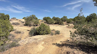
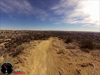
Photos of Farmington Mountain Bike
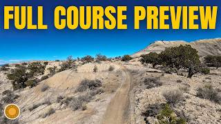
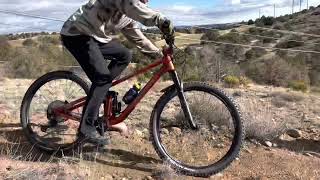
Videos of Farmington Mountain Bike
trail: Lunch Loop
0:10 |
17 |
Mar 30, 2026
trail: Seven Sisters
2:30 |
274 |
Jan 15, 2014
38:33 |
13 |
Mar 10, 2026
youtuber
![Single Tracks: East Glade Trails - Rigor Mortis]()

trail: Rigor Mortis
22:37 |
145 |
Apr 3, 2024 , Farmington

trail: Seven Sisters
3:47 |
278 |
Nov 14, 2010
trail: Pinnacle
2:38 |
237 |
Nov 22, 2022 , Farmington
trail: Seven Sisters
12:31 |
408 |
Apr 18, 2019 , Farmington
trail: Rigor Mortis
12:29 |
905 |
Apr 18, 2019 , Farmington
Recent Trail Reports
| status | trail | date | condition | info | user |
|---|---|---|---|---|---|
| Easy Way Back | May 11, 2026 @ 5:18pm (America/Denver) May 11, 2026 | Ideal | Artbradley | ||
| SE Fenceline | May 11, 2026 @ 5:18pm (America/Denver) May 11, 2026 | Ideal | Artbradley | ||
| MV/GC-Corridor | May 11, 2026 @ 5:18pm (America/Denver) May 11, 2026 | Ideal | Artbradley | ||
| Tight and twisty | May 11, 2026 @ 5:18pm (America/Denver) May 11, 2026 | Ideal | Artbradley | ||
| Rim | May 11, 2026 @ 5:18pm (America/Denver) May 11, 2026 | Ideal | Artbradley | ||
| Jumpline | May 11, 2026 @ 5:18pm (America/Denver) May 11, 2026 | Dry | Artbradley | ||
| Climb to the top | May 11, 2026 @ 5:18pm (America/Denver) May 11, 2026 | Dry | Artbradley | ||
| Perimeter | May 11, 2026 @ 5:18pm (America/Denver) May 11, 2026 | Ideal | Artbradley | ||
| Paved Pump Track (Velosolutions) | May 11, 2026 @ 5:18pm (America/Denver) May 11, 2026 | Ideal | Artbradley | ||
| Limber | Apr 30, 2026 @ 11:09am (America/Denver) Apr 30, 2026 | Very Dry | Reggimann |
Activity Feed
| username | action | type | title | date |
|---|---|---|---|---|
| m0fHC3 | wishlist | trail | activity #97425577 | Jun 20, 2026 @ 12:59pm 3 days |
| Ztb8swTd | wishlist | trail | activity #95260728 | May 22, 2026 @ 12:23pm May 22, 2026 |
| Chickensheetbkr | ridden | trail | activity #95000328 | May 18, 2026 @ 2:25pm May 18, 2026 |
| judahGcb6I2 | ridden | trail | activity #94981429 and 1 more | May 18, 2026 @ 9:31am May 18, 2026 |
| andramcole | wishlist | trail | activity #94747670 | May 15, 2026 @ 6:51am May 15, 2026 |
Recent Comments
| username | type | title | comment | date |
|---|---|---|---|---|
| trail | Great new addition much fun! Short but sweet... | Nov 28, 2025 @ 4:22pm Nov 28, 2025 | ||
| trail | Great trail perfect compliment to the other... | Nov 28, 2025 @ 4:18pm Nov 28, 2025 | ||
| trail | Thanks for the new trail nice work. Great... | Nov 28, 2025 @ 4:12pm Nov 28, 2025 | ||
| trail | Always a great change of pace kinda trail.... | Nov 28, 2025 @ 3:54pm Nov 28, 2025 | ||
| trail | Rode it today , all of it enjoyed it very... | Nov 28, 2025 @ 2:03pm Nov 28, 2025 |
Local Badges
-

Epic Ride Climb 2k8 awarded -

Climbing 10k Badge48 awarded -

Climbing 100k Badge6 awarded -

Epic Ride Descent 2k8 awarded -

Descent 10k Badge49 awarded -

Descent 100k Badge7 awarded
Bike & Skill Parks
| name | type | city | rating |
|---|---|---|---|
| East Glade Trail Head Skills Park | skill park | Farmington | |
| San Juan College Bike Park | skill park | Farmington |
Activity Type Stats
| activitytype | trails | distance | descent | descent distance | total vertical | rating | global rank | state rank | photos | reports | routes | ridelogs |
|---|---|---|---|---|---|---|---|---|---|---|---|---|
| Mountain Bike | 117 | 105 miles | 8,225 ft | 38 miles | 1,089 ft | #1,093 | #424 | 165 | 1,319 | 7 | 15,115 | |
| E-Bike | 85 | 66 miles | 4,911 ft | 21 miles | 1,089 ft | #2,045 | #924 | 1,241 | 392 | |||
| Gravel Bike | 6 | 3 miles | 141 ft | 1 mile | 102 ft | #399 | #983 | 43 | 4 | 7 | ||
| Winter Fat Bike | 1 | #225 | #996 | 1 | ||||||||
| Horse | 11 | 12 miles | 459 ft | 4 miles | 797 ft | #1,473 | #868 | 39 | ||||
| Hike | 108 | 101 miles | 7,106 ft | 34 miles | 1,089 ft | #2,040 | #861 | 1,286 | 1 | 389 | ||
| Trail Running | 110 | 102 miles | 7,323 ft | 35 miles | 1,089 ft | #1,483 | #522 | 1,286 | 1 | 847 | ||
| Dirtbike/Moto | 1 | 10 miles | 404 ft | 3 miles | 459 ft | 33 | 50 |
Frequently Asked Questions About Farmington
▼
What are the best places to ride in Farmington?
Farmington has 6 areas to explore for mountain biking. The top rated areas are:
▼
What are the highest rated mountain biking trails in Farmington?
The highest rated mountain biking trails in Farmington are:
- Fence Line (4.4/5)
- Lake View (4.4/5)
- Jackrabbit Trail (4.2/5)
- Rigor Mortis Extended (4.2/5)
- Art Class (4.2/5)
▼
What is the best time of the year to ride in Farmington?
Based on ride log data, the most popular months to ride in Farmington are:
- July (185 activities)
- September (151 activities)
- August (144 activities)
▼
Where can I park to ride in Farmington?
There are 13 parking locations listed in Farmington. The most popular parking spots are: View all parking and trailhead locations on the map to plan your visit.
Activities
Trails
- By crankyanken & contributors
- Admins: FAST
- #3994 - 36,654 views
- farmington activity log | embed map of Farmington mountain bike trails | farmington mountain biking points of interest
Downloading of trail gps tracks in kml & gpx formats is enabled for Farmington.
You must login to download files.