close
-
Layers w
- Weather Layers
- Pro
- Pro
- Pro
- Pro
- Pro
- Pro
- More Layers
- Pro
- Pro
- Pro
- Pro
-
Upgrade to

3D
Trail Conditions
- Unknown
- Snow Groomed
- Snow Packed
- Snow Covered
- Snow Cover Partial
- Freeze/thaw Cycle
- Icy
- Prevalent Mud
- Wet
- Variable
- Ideal
- Dry
- Very Dry
Trail Flow (Ridden Direction)
Trailforks scans users ridelogs to determine the most popular direction each trail is ridden. A good flowing trail network will have most trails flowing in a single direction according to their intension.
The colour categories are based on what percentage of riders are riding a trail in its intended direction.
The colour categories are based on what percentage of riders are riding a trail in its intended direction.
- > 96%
- > 90%
- > 80%
- > 70%
- > 50%
- < 50%
- bi-directional trail
- no data
Trail Last Ridden
Trailforks scans ridelogs to determine the last time a trail was ridden.
- < 2 days
- < 1 week
- < 2 weeks
- < 1 month
- < 6 months
- > 6 months
Trail Ridden Direction
The intended direction a trail should be ridden.
- Downhill Only
- Downhill Primary
- Both Directions
- Uphill Primary
- Uphill Only
- One Direction
Contribute Details
Colors indicate trail is missing specified detail.
- Description
- Photos
- Description & Photos
- Videos
Trail Popularity ?
Trailforks scans ridelogs to determine which trails are ridden the most in the last 9 months.
Trails are compared with nearby trails in the same city region with a possible 25 colour shades.
Think of this as a heatmap, more rides = more kinetic energy = warmer colors.
- most popular
- popular
- less popular
- not popular
ATV/ORV/OHV Filter
Max Vehicle Width
inches
US Cell Coverage
Legend

Radar Time
Activity Recordings
Trailforks uses anonymized public activity data.
?
Activity Recordings
Trailforks uses anonymized public activity data.
?
Personal Heatmap
▶
Activity Types
all
/
none
▶
Options
2
Date range
month
–
Winter Trails
Warning
A routing network for winter maps does not exist. Selecting trails using the winter trails layer has been disabled.
Missing Trails
Most Popular
Least Popular
Trails are colored based on popularity. The more popular a trail is, the more red. Less popular trails trend towards green.
Jump Magnitude Heatmap
Heatmap of where riders jump on trails. Zoom in to see individual jumps, click circles to view jump details.
BC Backroad Status
![map legend]()
Service Road Atlas is a free to use, community-driven service for viewing and creating reports on the numerous back-country service roads around B.C. and Alberta.

Slope Aspect
Direction the slope faces
Trails Deemphasized
Trails are shown in grey.
Only show trails with no bike usage.
Suggested Layers
Based on selected activity type
Save the current map location and zoom level as your default home location whenever this page is loaded.
Save
No description for Fayetteville has been added yet!
Login or register to submit one.

Region Supporters & Maintainers
![IMBA Bronze Ride Center]()
IMBA Bronze Ride Center
since 2014Sponsor
IMBA Ride Center
Fayetteville
Activities Click to view
- Mountain Bike
173 trails
- E-Bike
157 trails
- Gravel Bike
0 trails
- Adaptive Bike
0 trails
- Winter Fat Bike
0 trails
- Horse
14 trails
- Hike
179 trails
- Trail Running
178 trails
Region Details
- 7
- 42
- 55
- 34
- 28
- 3
Region Status
Open as of 3 daysStats
- Avg Trail Rating
- Trails (view details)
- 177
- Trails Mountain Bike
- 173
- Trails E-Bike
- 157
- Trails Horse
- 14
- Trails Hike
- 179
- Trails Trail Running
- 178
- Total Distance
- 162 miles
- Total Descent
- 12,251 ft
- Total Vertical
- 725 ft
- Highest Trailhead
- 1,821 ft
- Reports
- 2,957
- Photos
- 324
- Ridden Counter
- 47,573
Sub Regions
-
Centennial Park at Millsap Mountain
- 1
- 7
- 8
- 14
-
Gregory Park
- 2
- 1
-
Lake Fayetteville
- 4
- 2
-
Lake Wedington
- 2
- 4
- 1
- 1
-
Markham Hill
- 1
- 2
- 1
-
Mt Kessler
- 2
- 2
- 2
- 4
- 2
-
Mt Sequoyah Woods
- 1
- 4
- 2
-
Ramay JH School Trails
- 1
- 2
- 1
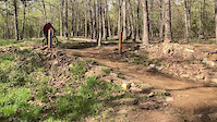
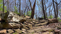
Popular Fayetteville Mountain Biking Trails
• 90 ★ 4.4 • 1 mile • 242 ft • 1,022 •
The is a flowy intermediate singletrack that includes berms and small rock sections. There are a few small booster options if riders want to get sendy. The intersects the bottom of Red Rum and Chunky downhill trails as it climbs back up...
• 95 ★ 4.5 • 1 mile • 68 ft • 871 •
This segment connects and and will some day continue onto the U of A campus. Ride it both directions at Centennial as a connector or ride through the park as you do the Traverse Trail Loop.
• 85 ★ 4.2 • 3,442 ft • 54 ft • 853 •
This is a world cup caliber cross-country race course. There are five segments, this is the far North Segment. All Segments run clockwise. There are short sections where the track shares the CX race course "Chasing Gold". Be on the...
• 100 ★ 5.0 • 1,804 ft • 77 ft • 821 •
This is the second section of the clockwise loop that continues from Loop #1 on World Cup. Continue south on from #1, entrance to #2 is immediately to the left, cutting across Chasing Gold.
• 95 ★ 4.0 • 1,437 ft • 3 ft • 796 •
This is the southern portion of the trail and allows for either a return to the start/finish area after of the OZ XC course or a crossing after WC#4, or a crossing to join with WC#5 as was done during the Team USA Olympic Trials.
• 90 ★ 5.0 • 1,142 ft • 31 ft • 785 •
This is the last segment in the course. There is an A-line drop on the west (right) or a go-around rock garden on the East (left). The choice is yours, choose wisely:)
• 90 ★ 4.2 • 3,625 ft • 36 ft • 761 •
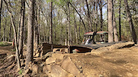
New Trail Wood bridge crossing, rocks, hardpack dirt, construction still in progress but mostly done.
Fayetteville Mountain Bike Routes
★ 5.0 • 8 miles • 912 ft • 4 • Loop •
This was my go to loop starting and ending at the Smokehouse. Has a good amount of singletrack with some...
★ 5.0 • 5 miles • 636 ft • 4 • Loop •
Good trail loop for those looking for a connected and quick ride. Enjoy fast downhill trails like , and...
★ 5.0 • 12 miles • 1,384 ft • 14 •
One day at Centennial Park to ride all the best trails!
12 miles • 1,364 ft • 7 •
Kessler can be a bit of a beatdown, but this route follows the smoother, flowier trails between Kessler...
★ 3.0 • 16 miles • 1,908 ft • 17 •
Tough yet awesome course. This route cover plenty of berms, jumps, drops, climbing, and fast downhill...
3 miles • 467 ft • 3 • Point to Point •
Point to point ride on Kessler trail network.
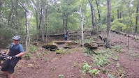
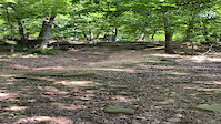
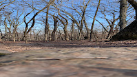
Photos of Fayetteville Mountain Bike
Videos of Fayetteville Mountain Bike
trail: Precipitous
0:07 |
90 |
Jul 1, 2025
trail: Centennial Trails
0:16 |
|
Aug 4, 2023

trail: Centennial Trails
0:16 |
|
Aug 4, 2023
trail: Western Myth
0:07 |
|
Jun 18, 2021
trail: Junk Drawer
0:06 |
533 |
Apr 23, 2021

trail: Junk Drawer
0:05 |
423 |
Apr 23, 2021
trail: Junk Drawer
0:05 |
|
Apr 23, 2021
trail: Hail Mary
0:09 |
552 |
Mar 29, 2021
Current Trail Warnings
| status | trail | date | condition | user | info |
|---|---|---|---|---|---|
| Saddle Up | Jun 15, 2026 @ 3:12pm (Europe/Berlin) 3 days | Unknown | robbiethetrailtroll OORC | Trail will remain closed as we work on a... |
Recent Trail Reports
Activity Feed
| username | action | type | title | date |
|---|---|---|---|---|
| robbiethetrailtroll | add | report | activity #97036189 | Jun 15, 2026 @ 6:12am 3 days |
| robbiethetrailtroll | add | report | activity #97029185 | Jun 15, 2026 @ 2:31am Jun 15, 2026 |
| robbiethetrailtroll | add | report | activity #97029166 | Jun 15, 2026 @ 2:30am Jun 15, 2026 |
| Sisteezy | wishlist | region | activity #96837520 | Jun 12, 2026 @ 5:12pm Jun 12, 2026 |
| robbiethetrailtroll | comment | report | activity #96742510 | Jun 11, 2026 @ 9:18am Jun 11, 2026 |
Recent Comments
| username | type | title | comment | date |
|---|---|---|---|---|
| report | Hey Dale, thanks for clearing the one.... | Jun 11, 2026 @ 9:18am Jun 11, 2026 | ||
| trail | Awesome trail but I feel like they... | May 16, 2026 @ 1:13pm May 16, 2026 | ||
| trail | If you don’t like this trail you aren’t a... | May 11, 2026 @ 6:26pm May 11, 2026 | ||
| report | Just passed the first road crossing heading north. | Nov 4, 2025 @ 3:31pm Nov 4, 2025 | ||
| report | Where are the trees down on Twin Knobs trail? | Nov 2, 2025 @ 3:51pm Nov 2, 2025 |
Local Badges
-

Completionist0 awarded -

Big Ride 30k6,365 awarded -

Epic Ride 50k2,571 awarded -

Top 10 Trails0 awarded -

Descent 100k Badge10 awarded -
Completionist1 awarded
Bike & Skill Parks
| name | type | city | rating |
|---|---|---|---|
| Mitchusson Skills Park | skill park | Fayetteville |
Activity Type Stats
| activitytype | trails | distance | descent | descent distance | total vertical | rating | global rank | state rank | photos | reports | routes | ridelogs |
|---|---|---|---|---|---|---|---|---|---|---|---|---|
| Mountain Bike | 173 | 155 miles | 11,568 ft | 56 miles | 725 ft | #441 | #162 | 314 | 2,955 | 20 | 42,675 | |
| E-Bike | 157 | 149 miles | 11,152 ft | 55 miles | 725 ft | #695 | #751 | 5 | 2,863 | 8 | 2,598 | |
| Horse | 14 | 7 miles | 187 ft | 2 miles | 144 ft | #2,149 | #1,192 | 151 | 3 | |||
| Hike | 179 | 160 miles | 11,926 ft | 58 miles | 725 ft | #1,167 | #539 | 2 | 2,953 | 3 | 3,038 | |
| Trail Running | 178 | 160 miles | 11,926 ft | 58 miles | 725 ft | #825 | #311 | 2,952 | 3 | 3,086 |
Frequently Asked Questions About Fayetteville
▼
What are the best places to ride in Fayetteville?
Fayetteville has 11 areas to explore for mountain biking. The top rated areas are:
▼
What are the highest rated mountain biking trails in Fayetteville?
The highest rated mountain biking trails in Fayetteville are:
- Chinkapin Oak (4.4/5)
- Tailwind (4.4/5)
- Rolling Thunder (4.4/5)
- World Cup #2 (4.3/5)
- Captain Fantastic (4.3/5)
▼
What is the best time of the year to ride in Fayetteville?
Based on ride log data, the most popular months to ride in Fayetteville are:
- July (201 activities)
- September (195 activities)
- October (183 activities)
▼
Where can I park to ride in Fayetteville?
There are 11 parking locations listed in Fayetteville. The most popular parking spots are: View all parking and trailhead locations on the map to plan your visit.
Activities
Trails
- By brenthillier
 NSMBA TRAILFORKS & contributors
 - Admins: OZ TRAILS, thomcerny
- #3742 - 20,147 views
- fayetteville activity log | embed map of Fayetteville mountain bike trails | fayetteville mountain biking points of interest
Downloading of trail gps tracks in kml & gpx formats is enabled for Fayetteville.
You must login to download files.