close
-
Layers w
- Weather Layers
- Pro
- Pro
- Pro
- Pro
- Pro
- Pro
- More Layers
- Pro
- Pro
- Pro
- Pro
-
Upgrade to

3D
Trail Conditions
- Unknown
- Snow Groomed
- Snow Packed
- Snow Covered
- Snow Cover Partial
- Freeze/thaw Cycle
- Icy
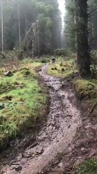
- Prevalent Mud
- Wet
- Variable
- Ideal
- Dry
- Very Dry
Trail Flow (Ridden Direction)
Trailforks scans users ridelogs to determine the most popular direction each trail is ridden. A good flowing trail network will have most trails flowing in a single direction according to their intension.
The colour categories are based on what percentage of riders are riding a trail in its intended direction.
The colour categories are based on what percentage of riders are riding a trail in its intended direction.
- > 96%
- > 90%
- > 80%
- > 70%
- > 50%
- < 50%
- bi-directional trail
- no data
Trail Last Ridden
Trailforks scans ridelogs to determine the last time a trail was ridden.
- < 2 days
- < 1 week
- < 2 weeks
- < 1 month
- < 6 months
- > 6 months
Trail Ridden Direction
The intended direction a trail should be ridden.
- Downhill Only
- Downhill Primary
- Both Directions
- Uphill Primary
- Uphill Only
- One Direction
Contribute Details
Colors indicate trail is missing specified detail.
- Description
- Photos
- Description & Photos
- Videos
Trail Popularity ?
Trailforks scans ridelogs to determine which trails are ridden the most in the last 9 months.
Trails are compared with nearby trails in the same city region with a possible 25 colour shades.
Think of this as a heatmap, more rides = more kinetic energy = warmer colors.
- most popular
- popular
- less popular
- not popular
ATV/ORV/OHV Filter
Max Vehicle Width
inches
US Cell Coverage
Legend

Radar Time
Activity Recordings
Trailforks uses anonymized public activity data.
?
Activity Recordings
Trailforks uses anonymized public activity data.
?
Personal Heatmap
▶
Activity Types
all
/
none
▶
Options
2
Date range
month
–
Winter Trails
Warning
A routing network for winter maps does not exist. Selecting trails using the winter trails layer has been disabled.
Missing Trails
Most Popular
Least Popular
Trails are colored based on popularity. The more popular a trail is, the more red. Less popular trails trend towards green.
Jump Magnitude Heatmap
Heatmap of where riders jump on trails. Zoom in to see individual jumps, click circles to view jump details.
BC Backroad Status
![map legend]()
Service Road Atlas is a free to use, community-driven service for viewing and creating reports on the numerous back-country service roads around B.C. and Alberta.

Slope Aspect
Direction the slope faces
Trails Deemphasized
Trails are shown in grey.
Only show trails with no bike usage.
Suggested Layers
Based on selected activity type
Save the current map location and zoom level as your default home location whenever this page is loaded.
SavePopular Trail Networks
view all areas »
No description for Fife Region has been added yet!
Login or register to submit one.
This region uses the Uk/Euro style trail grading system.
Activities Click to view
- Mountain Bike
752 trails
- E-Bike
698 trails
- Horse
56 trails
- Hike
623 trails
- Trail Running
624 trails
Region Details
- 159
- 238
- 209
- 90
- 44
- 1
Stats
- Avg Trail Rating
- Trails (view details)
- 743
- Trails Mountain Bike
- 753
- Trails E-Bike
- 698
- Trails Horse
- 56
- Trails Hike
- 624
- Trails Trail Running
- 624
- Trails Nordic Ski
- 1
- Total Distance
- 311 miles
- Total Descent
- 38,515 ft
- Total Vertical
- 1,693 ft
- Highest Trailhead
- 1,695 ft
- Reports
- 1,800
- Photos
- 206
- Ridden Counter
- 57,342
Sub Regions
- Aberdour (1)
- Auchtermuchty (116)
- Pitmedden (114)
- Ballingry (66)
- Benarty Hill (23)
- Lochore Meadows (37)
- Burntisland (19)
- The Binn (13)
- Cowdenbeath (20)
- Cullaloe (20)
- Cupar (7)
- Cairngreen Wood (7)
- Cupar (1)
- Dalgety Bay (28)
- Dunfermline (4)
- Falkland (150)
- Lomond Hills (150)
- Glenrothes (63)
- Kelty (72)
- Blairadam (72)
- Kincardine (57)
- Devilla Forest (52)
- Kinross (2)
- Kirkcaldy (55)
- Dunniker Park (10)
- Middle Den (10)
- Ravenscraig Park (22)
- Leven (7)
- Scotlandwell (8)
- St Andrews (42)
- Bishop's Wood (2)
- Kemback Woods (40)
- Tayport (21)
- Tentsmuir Forest (21)
- Dean Plantation (10)
- Waterloo Woods (0)
Popular Fife Region Mountain Biking Trails
• 100 ★ 2.0 • 1,093 ft • 30 ft • 522 •
/egress trail for bottom of DH trails - used for getting back to carpark
• 90 ★ 4.6 • 2,671 ft • 3 ft • 515 •
Easy direct cycle up to the start via the makes this a good one for multiple runs. Runs along the side of an old burn. Usually relatively dry route even in the depths of Winter. Fast and flowing first quarter, middle section has a few...
• 95 ★ 5.0 • 948 ft • 0 ft • 490 •
Popular black difficulty singletrack. This mountain bike primary trail can be used one direction and has a moderate overall physical rating with a 0 ft blue climb. It features berm, drop and rock garden. Trail visibility is always easy to follow. On average it takes 2 minutes to complete this trail.
• 5 ★ 4.0 • 827 ft • 0 ft • 458 •
short sub 1 min descent to main carpark. starts of with some short steep sections leading to established built up berms and small jumps. a 4 ft drop leads you into a tight fresher section of trail before the end
• 100 ★ 3.7 • 1,768 ft • 0 ft • 445 •
loamy top half, -tech bottom half with sizeable features for the average rider. the bottom half needs the rider to have to clean and together some of the features which are all variations of drops utilising windblown trees. a chicken...
• 100 ★ 4.0 • 860 ft • 0 ft • 442 •
fast and technical. last drop onto the is a doozy
• 100 ★ 4.5 • 912 ft • 0 ft • 422 •
Popular black difficulty singletrack. This mountain bike primary trail can be used one direction and has a moderate overall physical rating with a 0 ft blue climb. It features berm, drop, jump, gap jump, rock face and rock garden. Trail visibility is always easy to follow. On average it takes 1 minutes to complete this trail.
• 90 ★ 3.0 • 3,048 ft • 44 ft • 417 •
Popular black difficulty singletrack. This mountain bike primary trail can be used one direction. It features drop, rock face and rock garden. On average it takes 7 minutes to complete this trail.
Fife Region Mountain Bike Routes
10 miles • 1,403 ft • 21 • Loop •
typical singletrack loop for most folk looking to the majority of pitmedden lovely natural singletrack the...
★ 2.0 • 12 miles • 455 ft • 8 • Loop •
Circular route of Loch Leven using the Loch Leven Heritage Trail. Suitable for beginners and families,...
★ 1.0 • 8 miles • 950 ft • 8 • Loop •
8 mile loop starting and ending at Craigmead Car Park. This route is a mix of grassy singletrack, double...
14 miles • 1,257 ft • 0 • Loop •
For those looking to venture into the Lomonds for the first time, here is a taster route that will give a...
Photos of Fife Region Mountain Bike
Videos of Fife Region Mountain Bike
trail: Bagpuss
0:23 |
224 |
Dec 15, 2020
trail: Normans Law Path
0:25 |
85 |
Nov 4, 2019

trail: Normans Law Path
2:16 |
89 |
Aug 8, 2019
trail: Benarty DH
2:55 |
687 |
Apr 7, 2019
trail: Monster
2:25 |
120 |
Jan 6, 2019

trail: Lost
7:31 |
12210 |
Sep 12, 2018

trail: Benarty DH
4:06 |
2914 |
Jun 23, 2018
trail: Lost
2:13 |
4930 |
May 27, 2018
Recent Trail Reports
Activity Feed
| username | action | type | title | date |
|---|---|---|---|---|
| mOjiFf | ridden | trail | activity #97202289 | Jun 17, 2026 @ 12:17pm Jun 17, 2026 |
| mOjiFf | ridden | trail | activity #97202127 and 8 more | Jun 17, 2026 @ 12:15pm Jun 17, 2026 |
| jas915 | add | report | activity #96723255 and 5 more | Jun 11, 2026 @ 1:03am Jun 11, 2026 |
| scodavie | add | trail | activity #96221027 | Jun 4, 2026 @ 6:00am Jun 4, 2026 |
| ddd333hhh | add | report | activity #96033928 and 9 more | Jun 1, 2026 @ 12:19pm Jun 1, 2026 |
Recent Comments
| username | type | title | comment | date |
|---|---|---|---|---|
| trail | It was built by a dh racer I know him aswell... | May 12, 2026 @ 3:10am May 12, 2026 | ||
| trail | Tree down middle of bottom part | Mar 23, 2026 @ 8:25am Mar 23, 2026 | ||
| trail | Not rideable due to numerous failed trees. | Nov 22, 2025 @ 5:44am Nov 22, 2025 | ||
| report | Trails on this part of the hill normally best... | Aug 24, 2025 @ 12:40am Aug 24, 2025 | ||
| report | Second this, tried to follow this route but... | Aug 23, 2025 @ 5:18pm Aug 23, 2025 |
Local Badges
-

TTA - Dominator Challenge76 awarded -

Descent 100k Badge0 awarded -
Descent 100k Badge0 awarded -
Descent 100k Badge0 awarded -
Descent 100k Badge0 awarded -
Descent 100k Badge0 awarded
Bike & Skill Parks
| name | type | city | rating |
|---|---|---|---|
| Dirt Jumps | skill park | Kirkcaldy | |
| Pump Action | skill park | Kirkcaldy | |
| White Wood Bike Park | skill park | Ballingry | |
| Bike Skills Loop | skill park | Ballingry |
Activity Type Stats
| activitytype | trails | distance | descent | descent distance | total vertical | rating | global rank | state rank | photos | reports | routes | ridelogs |
|---|---|---|---|---|---|---|---|---|---|---|---|---|
| Mountain Bike | 752 | 310 miles | 38,461 ft | 150 miles | 1,693 ft | 205 | 1,793 | 7 | 47,551 | |||
| E-Bike | 698 | 293 miles | 34,281 ft | 140 miles | 1,693 ft | 1,655 | 7 | 7,056 | ||||
| Horse | 56 | 44 miles | 3,406 ft | 19 miles | 915 ft | 156 | 1 | |||||
| Hike | 623 | 286 miles | 29,318 ft | 132 miles | 1,693 ft | 2 | 1,486 | 2 | 1,621 | |||
| Trail Running | 624 | 286 miles | 29,318 ft | 132 miles | 1,693 ft | 1,485 | 3 | 3,503 | ||||
| Nordic Ski | 1 | 15 |
Frequently Asked Questions About Fife Region
▼
What are the best places to ride in Fife Region?
Fife Region has 19 areas to explore for mountain biking. The top rated areas are:
▼
What are the highest rated mountain biking trails in Fife Region?
The highest rated mountain biking trails in Fife Region are:
- A river runs through it (4.3/5)
- Lumps And Bumps (4.3/5)
- Get out of jail free (4.3/5)
- Mud Monster (4.3/5)
- Lonies Wedge (4.3/5)
▼
What is the best time of the year to ride in Fife Region?
Based on ride log data, the most popular months to ride in Fife Region are:
- July (181 activities)
- September (177 activities)
- June (151 activities)
▼
What is the longest trail in Fife Region?
The longest trail in Fife Region is Loch Leven Heritage Trail at 4.5 miles. View all trails sorted by distance.
Activities
Trails
- By brenthillier
 NSMBA TRAILFORKS & contributors
 - Admins: UKTP, 20twenty-p, DMBinS, FLS
- #6951 - 21,476 views
- fife region activity log | embed map of Fife Region mountain bike trails | fife region mountain biking points of interest polygons
Downloading of trail gps tracks in kml & gpx formats is enabled for Fife Region.
You must login to download files.