close
-
Layers w
- Weather Layers
- Pro
- Pro
- Pro
- Pro
- Pro
- Pro
- More Layers
- Pro
- Pro
- Pro
- Pro
-
Upgrade to

3D
Trail Conditions
- Unknown
- Snow Groomed
- Snow Packed
- Snow Covered
- Snow Cover Partial
- Freeze/thaw Cycle
- Icy
- Prevalent Mud
- Wet
- Variable
- Ideal
- Dry
- Very Dry
Trail Flow (Ridden Direction)
Trailforks scans users ridelogs to determine the most popular direction each trail is ridden. A good flowing trail network will have most trails flowing in a single direction according to their intension.
The colour categories are based on what percentage of riders are riding a trail in its intended direction.
The colour categories are based on what percentage of riders are riding a trail in its intended direction.
- > 96%
- > 90%
- > 80%
- > 70%
- > 50%
- < 50%
- bi-directional trail
- no data
Trail Last Ridden
Trailforks scans ridelogs to determine the last time a trail was ridden.
- < 2 days
- < 1 week
- < 2 weeks
- < 1 month
- < 6 months
- > 6 months
Trail Ridden Direction
The intended direction a trail should be ridden.
- Downhill Only
- Downhill Primary
- Both Directions
- Uphill Primary
- Uphill Only
- One Direction
Contribute Details
Colors indicate trail is missing specified detail.
- Description
- Photos
- Description & Photos
- Videos
Trail Popularity ?
Trailforks scans ridelogs to determine which trails are ridden the most in the last 9 months.
Trails are compared with nearby trails in the same city region with a possible 25 colour shades.
Think of this as a heatmap, more rides = more kinetic energy = warmer colors.
- most popular
- popular
- less popular
- not popular
ATV/ORV/OHV Filter
Max Vehicle Width
inches
US Cell Coverage
Legend

Radar Time
Activity Recordings
Trailforks uses anonymized public activity data.
?
Activity Recordings
Trailforks uses anonymized public activity data.
?
Personal Heatmap
▶
Activity Types
all
/
none
▶
Options
2
Date range
month
–
Winter Trails
Warning
A routing network for winter maps does not exist. Selecting trails using the winter trails layer has been disabled.
Missing Trails
Most Popular
Least Popular
Trails are colored based on popularity. The more popular a trail is, the more red. Less popular trails trend towards green.
Jump Magnitude Heatmap
Heatmap of where riders jump on trails. Zoom in to see individual jumps, click circles to view jump details.
BC Backroad Status
![map legend]()
Service Road Atlas is a free to use, community-driven service for viewing and creating reports on the numerous back-country service roads around B.C. and Alberta.

Slope Aspect
Direction the slope faces
Trails Deemphasized
Trails are shown in grey.
Only show trails with no bike usage.
Suggested Layers
Based on selected activity type
Save the current map location and zoom level as your default home location whenever this page is loaded.
SaveA large high-mountain lake, with myriad trails, including a National Recreational Trail that goes around the lake.
 google parking directions
 Activities Click to view
- Mountain Bike
59 trails
- E-Bike
10 trails
- Horse
31 trails
- Hike
60 trails
- Trail Running
59 trails
- Dirtbike/Moto
11 trails
- ATV/ORV/OHV
11 trails
Region Details
- 10
- 2
- 19
- 17
- 5
Region Status
Caution as of Apr 3, 2026Stats
- Avg Trail Rating
- Trails (view details)
- 54
- Trails Mountain Bike
- 59
- Trails E-Bike
- 10
- Trails Horse
- 31
- Trails Hike
- 60
- Trails Trail Running
- 59
- Trails Dirtbike/Moto
- 11
- Trails ATV/ORV/OHV
- 11
- Total Distance
- 153 miles
- Total Descent
- 22,292 ft
- Total Vertical
- 4,692 ft
- Highest Trailhead
- 11,541 ft
- Reports
- 43
- Photos
- 107
- Ridden Counter
- 652
Articles
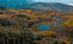
Utah’s Fishlake National Forest Is Magic in the Fall
Nov 9, 2021 from outsideonline.com
The forest is a sight to behold when the vibrant foliage is on full display
Popular Fish Lake Mountain Biking Trails
• 90 ★ 0.0 • 1 mile • 17 ft • 81 •
Popular green difficulty singletrack. This mountain bike primary trail can be used both directions. On average it takes 9 minutes to complete this trail.
• 85 ★ 0.0 • 4,484 ft • 276 ft • 60 •
Popular blue difficulty singletrack. This mountain bike primary trail can be used both directions and has a moderate overall physical rating with a 276 ft blue climb. On average it takes 11 minutes to complete this trail.
• 85 ★ 0.0 • 1,266 ft • 5 ft • 59 •
This is the lower section of Crater Lakes #116 that can be used to connect to the Lakeshore Trail. This trail continues up to crater lake, but is more geared to hikers
• 90 ★ 0.0 • 2 miles • 136 ft • 53 •
Popular green difficulty singletrack. This mountain bike primary trail can be used both directions. On average it takes 15 minutes to complete this trail.
• 85 ★ 0.0 • 2 miles • 135 ft • 43 •
Popular blue difficulty singletrack. This mountain bike primary trail can be used both directions and has a moderate overall physical rating with a 135 ft blue climb. On average it takes 15 minutes to complete this trail.
• 85 ★ 0.0 • 3 miles • 762 ft • 43 •
Popular black diamond difficulty singletrack. This mountain bike primary trail can be used both directions and has a hard overall physical rating with a 762 ft black diamond climb. On average it takes 1 hour2 minutes to complete this trail.
• 80 ★ 4.0 • 3 miles • 205 ft • 38 •
Popular double black diamond difficulty singletrack. This mountain bike primary trail can be used downhill primary and has a extreme overall physical rating with a 205 ft double black diamond climb. On average it takes 57 minutes to complete this trail.
• 90 ★ 5.0 • 2 miles • 160 ft • 31 •
Trail that connects Pelican Promontory and Pelican Canyon trail, then loops around above Bowery Haven Resort. Nice alternate route to riding through the resort on the Lakeshore Trail. The descent down into the campground goes down...
Fish Lake Mountain Bike Routes
★ 2.0 • 17 miles • 1,763 ft • 14 • Loop •
A scenic loop around Fish Lake, which can be hiked or biked in either direction or in sections.
36 miles • 5,267 ft • 3 • Loop •
Loop for bikepacking, mostly dirt road and easy singletrack with difficult to navigate hightop trail at...
Photos of Fish Lake Mountain Bike
Videos of Fish Lake Mountain Bike
youtuber
![Warm winter fat biking at Fish Lake! |...]()

trail: Bowery Bypass
31:12 |
35 |
Jan 2, 2026 , Beaver
youtuber
![Warm winter fat biking at Fish Lake! |...]()
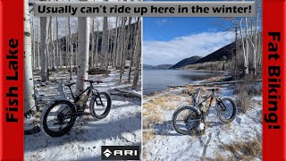
trail: Fish Lake Perimeter
31:12 |
39 |
Jan 2, 2026 , Beaver
youtuber
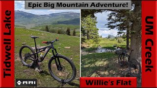
![Up to Willie's Flat & down Lower UM Creek!...]()
52:28 |
55 |
Sep 26, 2025 , Lyman
youtuber
![Aspens in glorious fall color on the...]()
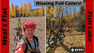
trail: Neal's Flat
34:17 |
97 |
Oct 13, 2024 , Lyman
youtuber
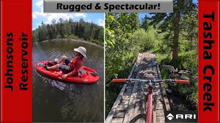
![Rugged & Spectacular Riding + Pedal...]()

trail: South Tasha (Frying Pan)
45:06 |
77 |
Jun 28, 2024 , Lyman
youtuber
![Rugged & Spectacular Riding + Pedal...]()
trail: Tasha Creek Connector
45:06 |
75 |
Jun 28, 2024 , Beaver
youtuber
![Rugged & Spectacular Riding + Pedal...]()

trail: Reflection Spring
45:06 |
76 |
Jun 28, 2024 , Lyman
youtuber
![Rugged & Spectacular Riding + Pedal...]()

trail: Crater-Johnson Connector
45:06 |
60 |
Jun 28, 2024 , Lyman
Recent Trail Reports
| status | trail | date | condition | info | user |
|---|---|---|---|---|---|
| Lake View Trail | Sep 30, 2025 @ 10:04am (America/Denver) Sep 30, 2025 | Unknown | Gholt789 | ||
| Pelican Canyon | Aug 24, 2024 @ 2:52pm Aug 24, 2024 | Ideal | MountainBikeBill SDMBA | ||
| Crater Lakes | Sep 23, 2022 @ 1:39pm Sep 23, 2022 | Unknown | jentzsch03 | ||
| Johnsons Loop | Sep 23, 2022 @ 1:39pm Sep 23, 2022 | Dry | jentzsch03 | ||
| Crater Lakes (116) | Sep 23, 2022 @ 1:39pm Sep 23, 2022 | Unknown | jentzsch03 | ||
| Fish Lake Perimeter | May 19, 2022 @ 6:22pm May 19, 2022 | Dry | johngchrist | ||
| Hightop Trail (South) | Aug 28, 2021 @ 9:20am Aug 28, 2021 | Dry | Zargyle | ||
| Lakeshore Southwest | Jul 23, 2021 @ 2:47pm Jul 23, 2021 | Ideal | jkgofam | ||
| Bowery Bypass | May 31, 2021 @ 12:08pm May 31, 2021 | Ideal | wcraig216 | ||
| Fish Lake Perimeter | May 31, 2021 @ 12:08pm May 31, 2021 | Ideal | wcraig216 |
National Scenic Trails & Official Routes
-
Great Western Trail
- Mountain Bike
- E-Bike
- Horse
- Hike
- Trail Running
- Dirtbike/Moto
- ATV/ORV/OHV

Activity Feed
| username | action | type | title | date |
|---|---|---|---|---|
| Trailmaven | comment | trail | activity #97006963 and 1 more | Jun 14, 2026 @ 2:57pm Jun 14, 2026 |
| uBvXWl | vote | trail | activity #95381123 | May 23, 2026 @ 11:38pm May 23, 2026 |
| thel0rax | add | report | activity #92017366 | Apr 5, 2026 @ 4:55pm Apr 5, 2026 |
| 22Lrek | ridden | trail | activity #89976539 and 6 more | Mar 4, 2026 @ 3:02pm Mar 4, 2026 |
| minerbiker | add | video | activity #86507869 and 1 more | Jan 2, 2026 @ 9:05am Jan 2, 2026 |
Recent Comments
| username | type | title | comment | date |
|---|---|---|---|---|
| trail | Nice trail still has several downed trees.... | Jun 14, 2026 @ 2:59pm Jun 14, 2026 | ||
| trail | Could be good with several reroutes and a lot... | Jun 14, 2026 @ 2:57pm Jun 14, 2026 | ||
| trail | Went up it. Hike a bike. Steep AF. | Oct 9, 2025 @ 12:07pm Oct 9, 2025 | ||
| trail | Do this trail when the Aspen leaves are turning. | Oct 9, 2025 @ 12:04pm Oct 9, 2025 | ||
| trail | This trail is best ridden as an out and back... | Aug 16, 2025 @ 1:31pm Aug 16, 2025 |
Nearby Areas
| name | distance | ||||
|---|---|---|---|---|---|
| Thousand Lake Mountain | 14 | 7 | 16.4 km | ||
| Gooseberry | 3 | 13 | 4 | 19.2 km | |
| Glenwood Hills | 5 | 2 | 1 | 21.4 km | |
| Pahvant Trail System | 5 | 9 | 6 | 26.5 km | |
| Salina Canyon | 1 | 6 | 3 | 27.9 km |
Local Badges
-

Completionist0 awarded
Activity Type Stats
| activitytype | trails | distance | descent | descent distance | total vertical | rating | global rank | state rank | photos | reports | routes | ridelogs |
|---|---|---|---|---|---|---|---|---|---|---|---|---|
| Mountain Bike | 59 | 153 miles | 22,238 ft | 59 miles | 3,809 ft | #2,297 | #787 | 83 | 43 | 2 | 384 | |
| E-Bike | 10 | 39 miles | 5,240 ft | 16 miles | 2,743 ft | #3,741 | #1,069 | 32 | 7 | |||
| Horse | 31 | 54 miles | 10,564 ft | 23 miles | 3,478 ft | #872 | #456 | 3 | 6 | 1 | 1 | |
| Hike | 60 | 153 miles | 22,293 ft | 59 miles | 4,692 ft | #583 | #309 | 14 | 40 | 1 | 78 | |
| Trail Running | 59 | 149 miles | 21,237 ft | 57 miles | 4,692 ft | #646 | #239 | 40 | 1 | 29 | ||
| Dirtbike/Moto | 11 | 39 miles | 5,240 ft | 16 miles | 2,743 ft | #659 | #224 | 1 | ||||
| ATV/ORV/OHV | 11 | 39 miles | 5,240 ft | 16 miles | 2,743 ft | #422 | #134 | 3 | 1 | 2 |
Frequently Asked Questions About Fish Lake
▼
What are the highest rated mountain biking trails in Fish Lake?
The highest rated mountain biking trails in Fish Lake are:
- Pelican Canyon (4.1/5)
- Hightop Trail (North) (4.1/5)
- Fish Lake Perimeter (4/5)
- Crater - Ivie Canyon (3.6/5)
- Johnsons Loop (3.2/5)
▼
What is the best time of the year to ride in Fish Lake?
Based on ride log data, the most popular months to ride in Fish Lake are:
- August (5 activities)
- July (5 activities)
- September (3 activities)
▼
Where can I park to ride in Fish Lake?
There are 10 parking locations listed in Fish Lake. The most popular parking spots are: View all parking and trailhead locations on the map to plan your visit.
▼
What is the longest trail in Fish Lake?
The longest trail in Fish Lake is GWT - SR72 to Last Chance at 9.6 miles. View all trails sorted by distance.
Activities
Trails
Points of Interest
- By todd
 Trailforks & contributors
 - Admins: jkwilliamz, UtahJohn, jpmcghee, jasonmalczyk
- #4828 - 10,865 views
- fish lake activity log | embed map of Fish Lake mountain bike trails | fish lake mountain biking points of interest
Downloading of trail gps tracks in kml & gpx formats is enabled for Fish Lake.
You must login to download files.