close
-
Layers w
- Weather Layers
- Pro
- Pro
- Pro
- Pro
- Pro
- Pro
- More Layers
- Pro
- Pro
- Pro
- Pro
-
Upgrade to

3D
Trail Conditions
- Unknown
- Snow Groomed
- Snow Packed
- Snow Covered
- Snow Cover Partial
- Freeze/thaw Cycle
- Icy
- Prevalent Mud
- Wet
- Variable
- Ideal
- Dry
- Very Dry
Trail Flow (Ridden Direction)
Trailforks scans users ridelogs to determine the most popular direction each trail is ridden. A good flowing trail network will have most trails flowing in a single direction according to their intension.
The colour categories are based on what percentage of riders are riding a trail in its intended direction.
The colour categories are based on what percentage of riders are riding a trail in its intended direction.
- > 96%
- > 90%
- > 80%
- > 70%
- > 50%
- < 50%
- bi-directional trail
- no data
Trail Last Ridden
Trailforks scans ridelogs to determine the last time a trail was ridden.
- < 2 days
- < 1 week
- < 2 weeks
- < 1 month
- < 6 months
- > 6 months
Trail Ridden Direction
The intended direction a trail should be ridden.
- Downhill Only
- Downhill Primary
- Both Directions
- Uphill Primary
- Uphill Only
- One Direction
Contribute Details
Colors indicate trail is missing specified detail.
- Description
- Photos
- Description & Photos
- Videos
Trail Popularity ?
Trailforks scans ridelogs to determine which trails are ridden the most in the last 9 months.
Trails are compared with nearby trails in the same city region with a possible 25 colour shades.
Think of this as a heatmap, more rides = more kinetic energy = warmer colors.
- most popular
- popular
- less popular
- not popular
ATV/ORV/OHV Filter
Max Vehicle Width
inches
US Cell Coverage
Legend

Radar Time
Activity Recordings
Trailforks uses anonymized public activity data.
?
Activity Recordings
Trailforks uses anonymized public activity data.
?
Personal Heatmap
▶
Activity Types
all
/
none
▶
Options
2
Date range
month
–
Winter Trails
Warning
A routing network for winter maps does not exist. Selecting trails using the winter trails layer has been disabled.
Missing Trails
Most Popular
Least Popular
Trails are colored based on popularity. The more popular a trail is, the more red. Less popular trails trend towards green.
Jump Magnitude Heatmap
Heatmap of where riders jump on trails. Zoom in to see individual jumps, click circles to view jump details.
BC Backroad Status
![map legend]()
Service Road Atlas is a free to use, community-driven service for viewing and creating reports on the numerous back-country service roads around B.C. and Alberta.

Slope Aspect
Direction the slope faces
Trails Deemphasized
Trails are shown in grey.
Only show trails with no bike usage.
Suggested Layers
Based on selected activity type
Save the current map location and zoom level as your default home location whenever this page is loaded.
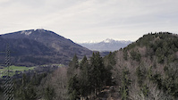
SaveThe Flachgau is the suburban neighborhood and the area around of the town of Salzburg – also known as "Salzburg-Umgebung". It is northern to the high-alpine regions of Salzburg, but you still can find some nice hills to ride. On the trailforks there is also the town of Salzburg included to the Flachgau, as it is clearer to get an better overview about the region.
eBikes Allowed:
Yes
AKA: Salzburg-Umgebung
This region uses the Uk/Euro style trail grading system.
Activities Click to view
- Mountain Bike
12 trails
- E-Bike
13 trails
- Horse
5 trails
- Hike
24 trails
- Trail Running
24 trails
Region Details
- 11
- 1
Stats
- Avg Trail Rating
- Trails (view details)
- 22
- Trails Mountain Bike
- 13
- Trails E-Bike
- 13
- Trails Horse
- 5
- Trails Hike
- 24
- Trails Trail Running
- 24
- Trails Backcountry Ski
- 3
- Total Distance
- 19 miles
- Total Descent
- 7,956 ft
- Total Vertical
- 4,607 ft
- Highest Trailhead
- 6,019 ft
- Reports
- 756
- Photos
- 355
- Ridden Counter
- 863
Popular Flachgau Mountain Biking Trails
• ★ 4.4 • 3,878 ft • 0 ft • 85 •
Der Singletrail wurde von Hand als naturnaher und anspruchsvoller Singletrail errichtet, je nach Witterung wird eine gute bis sehr gute Mountainbike Fahrtechnik vorausgesetzt. Von einer Benutzung durch wenig erfahrene...
Flachgau Mountain Bike Routes
★ 5.0 • 11 miles • 1,538 ft • 5 • Loop •
Wichtig: - Es gilt ein absolutes Nachtfahrverbot. - Es gilt eine Wintersperre von 30.11. bis 01.03. -...
★ 1.0 • 32 miles • 4,988 ft • 0 • Point to Point •
Famous Upper-Austrian mtb-route. Although it is called "trail", nearly everything is just a tarmac road or...
Photos of Flachgau Mountain Bike
Videos of Flachgau Mountain Bike
trail: ASKÖ Heuberg-Trail
0:45 |
336 |
Apr 28, 2023
0:16 |
44 |
Apr 20, 2026
3:06 |
99 |
Nov 19, 2025
0:04 |
122 |
Mar 5, 2024
trail: ASKÖ Heuberg-Trail
4:07 |
1104 |
Jun 24, 2023 , Salzburg
Recent Trail Reports
Activity Feed
| username | action | type | title | date |
|---|---|---|---|---|
| ASKOESalzburg | add | report | activity #97241206 and 1 more | Jun 18, 2026 @ 3:39am 2 days |
| ASKOESalzburg | add | report | activity #97241196 and 8 more | Jun 18, 2026 @ 3:39am 2 days |
| ASKOESalzburg | add | report | activity #97108427 and 21 more | Jun 16, 2026 @ 7:24am Jun 16, 2026 |
| ASKOESalzburg | add | report | activity #97108420 and 1 more | Jun 16, 2026 @ 7:24am Jun 16, 2026 |
| OleKliem | add | report | activity #96901862 and 3 more | Jun 13, 2026 @ 11:47am Jun 13, 2026 |
Recent Comments
| username | type | title | comment | date |
|---|---|---|---|---|
| skillpark | Hupfen ohne Ende und riesengroßer Pumptrack | Apr 20, 2026 @ 1:16am Apr 20, 2026 | ||
| skillpark | Grateful to design this one. I hope you guys... | Dec 13, 2025 @ 11:43am Dec 13, 2025 | ||
| skillpark | Ganz lustig zum Fahren und nett gebaut. 1... | Dec 14, 2024 @ 1:18pm Dec 14, 2024 | ||
| skillpark | Such a waste: - Opportunity. - Hopes. -... | Oct 13, 2024 @ 4:22am Oct 13, 2024 | ||
| trail | Sehr schöner Trail. Macht immer wieder Spaß... | Aug 16, 2023 @ 11:56am Aug 16, 2023 |
Local Badges
-

Epic Mountain Bike Climb 2k29 awarded -

Climbing 10k Badge20 awarded -

Mountain Biking 100k Badge1 awarded -

Epic Ride Descent 2k29 awarded -

Descent 10k Badge20 awarded -

Descent 100k Badge1 awarded
Bike & Skill Parks
| name | type | city | rating |
|---|---|---|---|
| Pumptrack Wals-Siezenheim | skill park | Wals-Siezenheim | |
| Pumptrack Koppl | skill park | Koppl | |
| BikePark Süd | skill park | Salzburg | |
| Pumptrack Berndorf | skill park | ||
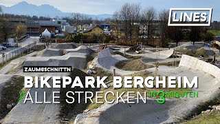
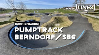
| Bikepark Bergheim | skill park | Bergheim |
Activity Type Stats
| activitytype | trails | distance | descent | descent distance | total vertical | rating | global rank | state rank | photos | reports | routes | ridelogs |
|---|---|---|---|---|---|---|---|---|---|---|---|---|
| Mountain Bike | 12 | 8 miles | 1,037 ft | 2 miles | 1,430 ft | 342 | 752 | 2 | 7,793 | |||
| E-Bike | 13 | 8 miles | 1,037 ft | 2 miles | 1,430 ft | 741 | 2 | 944 | ||||
| Horse | 5 | 5 miles | 33 ft | 2,953 ft | 1,414 ft | 53 | ||||||
| Hike | 24 | 13 miles | 6,142 ft | 7 miles | 2,749 ft | 268 | 1 | 644 | ||||
| Trail Running | 24 | 13 miles | 6,142 ft | 7 miles | 2,749 ft | 268 | 1 | 265 | ||||
| Backcountry Ski | 3 | 5 miles | 948 ft | 1 mile | 4,482 ft | 57 |
Frequently Asked Questions About Flachgau
▼
What are the best places to ride in Flachgau?
Flachgau has 2 areas to explore for mountain biking.
▼
What are the highest rated mountain biking trails in Flachgau?
The highest rated mountain biking trails in Flachgau are:
- ASKÖ Heuberg-Trail (4.3/5)
▼
What is the best time of the year to ride in Flachgau?
Based on ride log data, the most popular months to ride in Flachgau are:
- August (75 activities)
- September (58 activities)
- July (46 activities)
▼
What is the longest trail in Flachgau?
The longest trail in Flachgau is ASKÖ Heuberg-Trail at 3,878 ft. View all trails sorted by distance.
Activities
Trails
- By ktm-boy-69
 TRAILFORKS AED Maribor UpperTrails & contributors
 - Admins: ktm-boy-69, mpecsi, lines, larry81541, ktm-boy-69, lgs1, ASKOESalzburg
- #32608 - 3,747 views
- flachgau activity log | embed map of Flachgau mountain bike trails | flachgau mountain biking points of interest
Downloading of trail gps tracks in kml & gpx formats is enabled for Flachgau.
You must login to download files.