close
-
Layers w
- Weather Layers
- Pro
- Pro
- Pro
- Pro
- Pro
- Pro
- More Layers
- Pro
- Pro
- Pro
- Pro
-
Upgrade to

3D
Trail Conditions
- Unknown
- Snow Groomed
- Snow Packed
- Snow Covered
- Snow Cover Partial
- Freeze/thaw Cycle
- Icy
- Prevalent Mud
- Wet
- Variable
- Ideal
- Dry
- Very Dry
Trail Flow (Ridden Direction)
Trailforks scans users ridelogs to determine the most popular direction each trail is ridden. A good flowing trail network will have most trails flowing in a single direction according to their intension.
The colour categories are based on what percentage of riders are riding a trail in its intended direction.
The colour categories are based on what percentage of riders are riding a trail in its intended direction.
- > 96%
- > 90%
- > 80%
- > 70%
- > 50%
- < 50%
- bi-directional trail
- no data
Trail Last Ridden
Trailforks scans ridelogs to determine the last time a trail was ridden.
- < 2 days
- < 1 week
- < 2 weeks
- < 1 month
- < 6 months
- > 6 months
Trail Ridden Direction
The intended direction a trail should be ridden.
- Downhill Only
- Downhill Primary
- Both Directions
- Uphill Primary
- Uphill Only
- One Direction
Contribute Details
Colors indicate trail is missing specified detail.
- Description
- Photos
- Description & Photos
- Videos
Trail Popularity ?
Trailforks scans ridelogs to determine which trails are ridden the most in the last 9 months.
Trails are compared with nearby trails in the same city region with a possible 25 colour shades.
Think of this as a heatmap, more rides = more kinetic energy = warmer colors.
- most popular
- popular
- less popular
- not popular
ATV/ORV/OHV Filter
Max Vehicle Width
inches
US Cell Coverage
Legend

Radar Time
Activity Recordings
Trailforks uses anonymized public activity data.
?
Activity Recordings
Trailforks uses anonymized public activity data.
?
Personal Heatmap
▶
Activity Types
all
/
none
▶
Options
2
Date range
month
–
Winter Trails
Warning
A routing network for winter maps does not exist. Selecting trails using the winter trails layer has been disabled.
Missing Trails
Most Popular
Least Popular
Trails are colored based on popularity. The more popular a trail is, the more red. Less popular trails trend towards green.
Jump Magnitude Heatmap
Heatmap of where riders jump on trails. Zoom in to see individual jumps, click circles to view jump details.
BC Backroad Status
![map legend]()
Service Road Atlas is a free to use, community-driven service for viewing and creating reports on the numerous back-country service roads around B.C. and Alberta.

Slope Aspect
Direction the slope faces
Trails Deemphasized
Trails are shown in grey.
Only show trails with no bike usage.
Suggested Layers
Based on selected activity type
Save the current map location and zoom level as your default home location whenever this page is loaded.
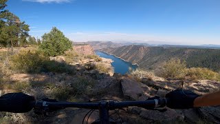
SaveThe Flaming Gorge area only has a few trails but they are well worth a try if you're in the area. Access is primarily via highway 44 that connects highway 191 from Vernal to Manila.
Primary Trail Type: Cross-Country
 google parking directions
 Activities Click to view
- Mountain Bike
11 trails
- Hike
13 trails
- Trail Running
13 trails
Region Details
- 3
- 3
- 5
Region Status
Open as of Jun 2, 2025Stats
- Avg Trail Rating
- Trails (view details)
- 13
- Trails Mountain Bike
- 11
- Trails Hike
- 13
- Trails Trail Running
- 13
- Total Distance
- 30 miles
- Total Descent
- 4,628 ft
- Total Vertical
- 2,459 ft
- Highest Trailhead
- 8,005 ft
- Reports
- 39
- Photos
- 72
- Ridden Counter
- 516
Popular Flaming Gorge Mountain Biking Trails
• 100 ★ 3.4 • 5 miles • 474 ft • 150 •
Mostly intermediate with a few technical spots. Amazing views of Flaming Gorge
• 75 ★ 3.0 • 1 mile • 295 ft • 36 •
Easy trail to start the spin up and around to the lookout
• 85 ★ 5.0 • 2 miles • 87 ft • 29 •
Popular green difficulty singletrack. This mountain bike primary trail can be used both directions and has a easy overall physical rating with a 87 ft green climb. On average it takes 12 minutes to complete this trail.
• 95 ★ 4.0 • 4,191 ft • 0 ft • 20 •
Popular blue difficulty singletrack. This mountain bike primary trail can be used both directions and has a moderate overall physical rating with a 0 ft blue climb. On average it takes 5 minutes to complete this trail.
• 50 ★ 3.0 • 7 miles • 293 ft • 11 •
Easy maintained trail that follows the north shore of the Green River. Only open to bikes during the winter
Photos of Flaming Gorge Mountain Bike
Videos of Flaming Gorge Mountain Bike
trail: Red Canyon Rim
15:40 |
342 |
Jan 7, 2023 , Manilla
Recent Trail Reports
| status | trail | date | condition | info | user |
|---|---|---|---|---|---|
| Little Hole NST | Jun 2, 2025 @ 10:28am Jun 2, 2025 | Very Dry | DebSpiel | ||
| Red Canyon Rim | May 4, 2025 @ 11:05am May 4, 2025 | Dry | dwhanson | ||
| Red Canyon Rim Spur | Jun 22, 2024 @ 7:19am Jun 22, 2024 | Ideal | DaviddeRX5X | ||
| Dowd Connector | Jun 20, 2024 @ 7:38am Jun 20, 2024 | Ideal | DaviddeRX5X | ||
| Dowd Mountain | Jun 20, 2024 @ 7:38am Jun 20, 2024 | Dry | DaviddeRX5X | ||
| Skull Creek CG | Jul 1, 2022 @ 6:09am Jul 1, 2022 | Wet | fletchridesagain | ||
| Dowd Mountain (N) | Jul 3, 2021 @ 7:48am Jul 3, 2021 | Ideal | fletchridesagain | ||
| Hideout Draw Road | Jul 27, 2020 @ 11:36am Jul 27, 2020 | Dry | MunnyP | ||
| Dowd Mountain DT | Jun 14, 2020 @ 6:36pm Jun 14, 2020 | Dry | aebryden | ||
| Bear Canyon Trail | Jul 25, 2018 @ 11:00am Jul 25, 2018 | Unknown | ppearson |
Activity Feed
| username | action | type | title | date |
|---|---|---|---|---|
| jmartin127 | wishlist | trail | activity #96735377 | Jun 11, 2026 @ 7:14am Jun 11, 2026 |
| jimandhisdamnbike | wishlist | trail | activity #96086857 | Jun 2, 2026 @ 8:39am Jun 2, 2026 |
| RobbyghQRlr | ridden | trail | activity #95490316 | May 25, 2026 @ 8:17am May 25, 2026 |
| Acolgate | wishlist | trail | activity #94849356 | May 16, 2026 @ 1:49pm May 16, 2026 |
| Acolgate | wishlist | region | activity #94842380 | May 16, 2026 @ 12:29pm May 16, 2026 |
Recent Comments
| username | type | title | comment | date |
|---|---|---|---|---|
| trail | I agree with jjrawlings, this is not a green... | Jun 2, 2025 @ 10:27am Jun 2, 2025 | ||
| trail | Don’t really see how this trail is rated... | Mar 31, 2025 @ 7:02am Mar 31, 2025 | ||
| trail | Take this Northbound around the lake, and take... | Aug 13, 2024 @ 4:44pm Aug 13, 2024 | ||
| trail | Ridden 6/15/24. Yes, rocky. Not a “family”... | Jun 17, 2024 @ 10:51am Jun 17, 2024 | ||
| trail | A beautiful addition to the rim ‘loop’.... | Oct 20, 2023 @ 6:35am Oct 20, 2023 |
Nearby Areas
| name | distance | ||||
|---|---|---|---|---|---|
| Eastern Uintas | 1 | 9 | 11 km | ||
| Sheep Creek (NE Uintas) | 3 | 1 | 19.8 km | ||
| Red Fleet Reservoir | 10 | 5 | 2 | 19.9 km | |
| Halfway Hollow | 34.3 km |
Activity Type Stats
| activitytype | trails | distance | descent | descent distance | total vertical | rating | global rank | state rank | photos | reports | routes | ridelogs |
|---|---|---|---|---|---|---|---|---|---|---|---|---|
| Mountain Bike | 11 | 30 miles | 4,547 ft | 17 miles | 2,461 ft | #6,377 | #2,405 | 72 | 39 | 360 | ||
| Hike | 13 | 30 miles | 4,629 ft | 18 miles | 2,461 ft | #6,941 | #2,522 | 39 | 134 | |||
| Trail Running | 13 | 30 miles | 4,629 ft | 18 miles | 2,461 ft | #6,338 | #2,008 | 39 | 21 |
Frequently Asked Questions About Flaming Gorge
▼
What are the highest rated mountain biking trails in Flaming Gorge?
The highest rated mountain biking trails in Flaming Gorge are:
- Bear Canyon Trail (4.2/5)
- Red Canyon Rim Spur (4.1/5)
- Skull Creek CG (4/5)
- Dowd Mountain (3.9/5)
- Dowd Mountain (S) (3.7/5)
▼
What is the best time of the year to ride in Flaming Gorge?
Based on ride log data, the most popular months to ride in Flaming Gorge are:
- June (14 activities)
- July (11 activities)
- September (8 activities)
▼
Where can I park to ride in Flaming Gorge?
There are 4 parking locations listed in Flaming Gorge. The most popular parking spots are: View all parking and trailhead locations on the map to plan your visit.
▼
What is the longest trail in Flaming Gorge?
The longest trail in Flaming Gorge is Little Hole NST at 7.2 miles. View all trails sorted by distance.
Activities
- By elewis33
 & contributors
 - Admins: jkwilliamz, UtahJohn, jpmcghee, jasonmalczyk
- #10124 - 8,376 views
- flaming gorge activity log | embed map of Flaming Gorge mountain bike trails | flaming gorge mountain biking points of interest
Downloading of trail gps tracks in kml & gpx formats is enabled for Flaming Gorge.
You must login to download files.