close
-
Layers w
- Weather Layers
- Pro
- Pro
- Pro
- Pro
- Pro
- Pro
- More Layers
- Pro
- Pro
- Pro
- Pro
-
Upgrade to

3D
Trail Conditions
- Unknown
- Snow Groomed
- Snow Packed
- Snow Covered
- Snow Cover Partial
- Freeze/thaw Cycle
- Icy
- Prevalent Mud
- Wet
- Variable
- Ideal
- Dry
- Very Dry
Trail Flow (Ridden Direction)
Trailforks scans users ridelogs to determine the most popular direction each trail is ridden. A good flowing trail network will have most trails flowing in a single direction according to their intension.
The colour categories are based on what percentage of riders are riding a trail in its intended direction.
The colour categories are based on what percentage of riders are riding a trail in its intended direction.
- > 96%
- > 90%
- > 80%
- > 70%
- > 50%
- < 50%
- bi-directional trail
- no data
Trail Last Ridden
Trailforks scans ridelogs to determine the last time a trail was ridden.
- < 2 days
- < 1 week
- < 2 weeks
- < 1 month
- < 6 months
- > 6 months
Trail Ridden Direction
The intended direction a trail should be ridden.
- Downhill Only
- Downhill Primary
- Both Directions
- Uphill Primary
- Uphill Only
- One Direction
Contribute Details
Colors indicate trail is missing specified detail.
- Description
- Photos
- Description & Photos
- Videos
Trail Popularity ?
Trailforks scans ridelogs to determine which trails are ridden the most in the last 9 months.
Trails are compared with nearby trails in the same city region with a possible 25 colour shades.
Think of this as a heatmap, more rides = more kinetic energy = warmer colors.
- most popular
- popular
- less popular
- not popular
ATV/ORV/OHV Filter
Max Vehicle Width
inches
US Cell Coverage
Legend

Radar Time
Activity Recordings
Trailforks uses anonymized public activity data.
?
Activity Recordings
Trailforks uses anonymized public activity data.
?
Personal Heatmap
▶
Activity Types
all
/
none
▶
Options
2
Date range
month
–
Winter Trails
Warning
A routing network for winter maps does not exist. Selecting trails using the winter trails layer has been disabled.
Missing Trails
Most Popular
Least Popular
Trails are colored based on popularity. The more popular a trail is, the more red. Less popular trails trend towards green.
Jump Magnitude Heatmap
Heatmap of where riders jump on trails. Zoom in to see individual jumps, click circles to view jump details.
BC Backroad Status
![map legend]()
Service Road Atlas is a free to use, community-driven service for viewing and creating reports on the numerous back-country service roads around B.C. and Alberta.

Slope Aspect
Direction the slope faces
Trails Deemphasized
Trails are shown in grey.
Only show trails with no bike usage.
Suggested Layers
Based on selected activity type
Save the current map location and zoom level as your default home location whenever this page is loaded.
SaveOn Trailforks the Florida map is divided into 9 Regions (sub-regions 1) and and 67 Counties (sub-regions 2), using the information on the website Florida Smart as a reference. https://www.floridasmart.com/local/county .
The nine regions are:
Northwest
North Central
Northeast
Central West
Central
Central East
South West
South East
Florida Keys
The nine regions are:
Northwest
North Central
Northeast
Central West
Central
Central East
South West
South East
Florida Keys
source: Florida Smart
Region Details
- 877
- 133
- 976
- 627
- 158
- 26
- 12
Stats
- Avg Trail Rating
- Trails (view details)
- 3,477
- Trails Mountain Bike
- 2,812
- Trails E-Bike
- 1,669
- Trails Gravel Bike
- 379
- Trails Adaptive Bike
- 384
- Trails Winter Fat Bike
- 262
- Trails Horse
- 355
- Trails Hike
- 3,067
- Trails Trail Running
- 3,055
- Trails Dirtbike/Moto
- 42
- Trails Observed Trials
- 1
- Trails ATV/ORV/OHV
- 49
- Trails Nordic Ski
- 4
- Total Distance
- 5,289 miles
- Total Descent
- 69,776 ft
- Total Vertical
- 289 ft
- Highest Trailhead
- 289 ft
- Reports
- 37,229
- Photos
- 8,953
- Ridden Counter
- 666,673
Articles
The Top 13 Beaches in Florida for Sun and Adventure
Jan 19, 2025 from outsideonline.com
Done with cold weather? From the Keys’ turquoise waters to the Panhandle’s white-sand shores and beyond, here are the Sunshines State's best...

What Did I Learn Trudging Through the Swamps of the Florida Trail? That I’m a Kink Hiker.
Feb 27, 2022 from outsideonline.com
The pain I experience while thru-hiking draws me back to the present and makes me more aware of my privilege

First Impressions: Tom Bradshaw & Christina Chappetta Ride the Best Trails in Tallahassee, Florida
Jun 6, 2022 from pinkbike.com
Tom Bradshaw and Christina Chappetta spend a day being pleasantly surprised at the state capital's trails.

Local Flavours: The Complete Guide to Riding in Tallahassee, Florida
Nov 30, 2020 from pinkbike.com
Everything you need to know about riding in Tallahasse, Florida.
Sub Regions
- Central East Florida Region (274)
- Brevard County (105)
- Indian River County (1)
- Martin County (88)
- Saint Lucie County (17)
- Volusia County (33)
- Central Florida Region (388)
- Hardee County (1)
- Highlands County (15)
- Lake County (63)
- Okeechobee County (81)
- Orange County (70)
- Osceola County (42)
- Polk County (67)
- Seminole County (69)
- Central West Florida (437)
- Charlotte County (41)
- Citrus County (3)
- Desoto County (1)
- Hernando County (47)
- Hillsborough County (173)
- Manatee County (22)
- Pasco County (25)
- Pinellas County (24)
- Sarasota County (128)
- Florida Keys Region (25)
- Big Pine Key (4)
- Boca Chicka Key (6)
- Cudjoe Key (2)
- Key Largo Island (2)
- Key West Island (5)
- Long Key (2)
- Ramrod Key (2)
- Vaca Key (2)
- North Central Florida Region (473)
- Alachua County (102)
- Bradford County (4)
- Columbia County (10)
- Dixie County (56)
- Gilchrist County (2)
- Hamilton County (49)
- Lafayette County (1)
- Levy County (101)
- Madison County (2)
- Marion County (147)
- Suwannee County (15)
- Taylor County (1)
- Union County (2)
- North East Florida Region (165)
- Baker County (1)
- Clay County (12)
- Duval County (87)
- Flagler County (20)
- Nassau County (9)
- Putnam County (12)
- St John's County (40)
- North West Florida Region - Panhandle (587)
- Bay County (25)
- Calhoun County (0)
- Escambia County (129)
- Franklin County (10)
- Gadsden County (5)
- Gulf County (50)
- Jackson County (12)
- Jefferson County (1)
- Leon County (177)
- Okaloosa County (72)
- Santa Rosa County (35)
- Wakulla County (6)
- Walton County (49)
- Washington County (12)
- South East Florida Region (382)
- Broward County (139)
- Miami-Dade County (142)
- Palm Beach County (106)
- South West Florida Region (136)
- Collier County (109)
- Glades County (1)
- Hendry County (3)
- Lee County (24)
Popular Florida Mountain Biking Trails
• 100 ★ 3.0 • 945 ft • 7 ft • 3,451 •
Popular green difficulty singletrack. This multi-use trail can be used both directions and has a easy overall physical rating with a 7 ft green climb. On average it takes 1 minutes to complete this trail.
• 100 ★ 4.9 • 2 miles • 39 ft • 2,945 •
Highly rated popular blue difficulty singletrack. This mountain bike primary trail can be used one direction and has a moderate overall physical rating with a 39 ft blue climb. It features drop, gap jump, rock face, rock garden and wallride. On average it takes 19 minutes to complete this trail.
• 90 ★ 4.7 • 2 miles • 226 ft • 2,804 •
Highly rated popular blue difficulty singletrack. This mountain bike primary trail can be used one direction and has a moderate overall physical rating. It features berm, bridge, drop, jump and skinny. Trail visibility is always easy to follow. On average it takes 13 minutes to complete this trail.
• 95 ★ 3.6 • 1 mile • 8 ft • 2,785 •
is a blue trail (moderate) in the San Trail System. This trail is accessible from the San Trailhead if you follow in either direction. Depending on which leg of you take, it will put you on opposite ends of . is one of the easier blues...
• 100 ★ 3.9 • 604 ft • 10 ft • 2,746 •
NOTE: this trail option is one-way-only from SOUTH to NORTH Immediately after the river bridge with the lake on your right - ascend this ADVANCED option, climbing the narrow trail with very steep sides to a 40’ ridge. Pause if you...
• 100 ★ 4.8 • 614 ft • 17 ft • 2,743 •
semi smooth rock stairs into double exiting to optional jump.
• 95 ★ 4.3 • 858 ft • 32 ft • 2,685 •
A short black diamond option including a rock drop at the beginning, steep descent into rollers, and a 180-degree into a quick downhill section.Fflat, mellow ending leading back into Roller Coaster.
• 100 ★ 4.3 • 873 ft • 5 ft • 2,634 •
Wooden Berms & Jumps. Fun flowy downhill built by Ray(Ray's Indoor Mountain Bike Parks)
Florida Mountain Bike Routes
DRY LOOP - Beginners Featured
★ 5.0 • 1 mile • 6 • Loop •
The DRY LOOP is in place after heavy and prolonged rain, whereby the and Trails are underwater. Note that...
Boldlygo Featured
13 miles • 26 ft • 7 • Loop •
Our most popular singletrack trail, starts at the Carlton Reserve area. Check out the map on the kiosk and...
★ 5.0 • 8 miles • 165 ft • 41 • Loop •
All trails from the car (no mary jane)
★ 5.0 • 3 miles • 9 • Loop •
The INTERMEDIATE DRY LOOP is in place after heavy and prolonged rain, whereby the and Trails are...
★ 3.0 • 8 miles • 128 ft • 31 •
All the trails at VK in one loop without backtracking.
★ 4.0 • 8 miles • 329 ft • 20 •
The UWF Trails Game Sides (Orange Loop) encircles a large clay pit area known as "The Playground". As of...
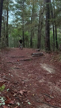
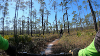
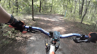
Photos of Florida Mountain Bike
Videos of Florida Mountain Bike
featured
![]()
trail: Blueberry Hill
0:06 |
178 |
Apr 20, 2021

0:40 |
11 |
Feb 8, 2026
trail: Wheee Doggie
0:06 |
31 |
Sep 14, 2025

trail: Moonscape
0:07 |
98 |
Jan 18, 2025
trail: Moonscape
0:07 |
37 |
Jan 18, 2025
trail: Spruce Creek Main Loop
5:12 |
62 |
Jan 3, 2025
trail: John Brown
0:13 |
|
Apr 8, 2024
Activity Feed
| username | action | type | title | date |
|---|---|---|---|---|
| OzS8v0 | wishlist | route | activity #97225835 and 1 more | Jun 17, 2026 @ 7:10pm 15 hours |
| OzS8v0 | wishlist | route | activity #97225648 | Jun 17, 2026 @ 7:07pm 15 hours |
| mstatus | add | photo | activity #97199362 | Jun 17, 2026 @ 11:38am 22 hours |
| 2MEF35 | wishlist | region | activity #97190368 | Jun 17, 2026 @ 9:37am 1 day |
| bikinbabylon | wishlist | region | activity #97189701 | Jun 17, 2026 @ 9:28am 1 day |
Recent Comments
| username | type | title | comment | date |
|---|---|---|---|---|
| trail | Trail has been 2/3 cleared and raked. New... | Jun 7, 2026 @ 5:37pm Jun 7, 2026 | ||
| report | A1 | May 22, 2026 @ 12:15pm May 22, 2026 | ||
| report | Mailbox in the middle of nowhere | May 22, 2026 @ 12:15pm May 22, 2026 | ||
| report | New trail boss has been keeping trail clear. ... | May 19, 2026 @ 5:22pm May 19, 2026 | ||
| report | Bridge repairs help transition | May 19, 2026 @ 3:53am May 19, 2026 |
Local Badges
-

Top 10 Trails54 awarded -

Epic Ride 50k14 awarded -

Completionist0 awarded -

10 Blue Trails5 awarded -
Top 10 Trails11 awarded -
Epic Ride 50k338 awarded
Bike & Skill Parks
| name | type | city | rating |
|---|---|---|---|
| The Beach N Peach Urban Bike Park | skill park | Jacksonville | |
| Santos Skill Park | skill park | Ocala | |
| Vortex | skill park | Ocala | |
| Orlando Mountain Bike Park | skill park | Orlando | |
| Pumptrack & Skills area | skill park | Sunrise |
Activity Type Stats
| activitytype | trails | distance | descent | descent distance | total vertical | rating | global rank | state rank | photos | reports | routes | ridelogs |
|---|---|---|---|---|---|---|---|---|---|---|---|---|
| Mountain Bike | 2,812 | 4,056 miles | 48,015 ft | 840 miles | 289 ft | #12 | 8,501 | 37,160 | 184 | 786,275 | ||
| E-Bike | 1,669 | 2,499 miles | 29,203 ft | 531 miles | 289 ft | #17 | 54 | 32,490 | 53 | 34,999 | ||
| Gravel Bike | 379 | 1,123 miles | 9,383 ft | 301 miles | 289 ft | #17 | 4 | 2,923 | 19 | 5,614 | ||
| Adaptive Bike | 384 | 878 miles | 8,179 ft | 244 miles | 289 ft | #15 | 5 | 2,539 | 5 | 76 | ||
| Winter Fat Bike | 262 | 382 miles | 6,677 ft | 102 miles | 285 ft | #27 | 3,555 | 47 | ||||
| Horse | 355 | 702 miles | 6,050 ft | 134 miles | 269 ft | #26 | 134 | 4,716 | 6 | 198 | ||
| Hike | 3,067 | 5,004 miles | 58,261 ft | 1,019 miles | 289 ft | #28 | 215 | 35,379 | 38 | 22,167 | ||
| Trail Running | 3,055 | 4,992 miles | 58,215 ft | 1,018 miles | 289 ft | #27 | 11 | 35,378 | 50 | 10,473 | ||
| Dirtbike/Moto | 42 | 75 miles | 1,808 ft | 22 miles | 194 ft | #31 | 4,606 | 312 | ||||
| Observed Trials | 1 | 3 miles | 82 ft | 1 mile | 79 ft | #12 | 6 | 80 | 316 | |||
| ATV/ORV/OHV | 49 | 104 miles | 1,243 ft | 23 miles | 197 ft | #27 | 4,603 | 209 | ||||
| Nordic Ski | 4 | 35 miles | 1,004 ft | 13 miles | 240 ft | #40 | 2 | 90 | 114 |
Activities
Trails
- By canadaka
 Trailforks & contributors
 - Admins: Map Team, IMBA, chuktA, msmcfate, WillieJacobsz, PlumbBobM, ReckitRolley, colinreuter, SORBA, A-MTBTP
- #3143 - 61,580 views
- florida activity log | embed map of Florida mountain bike trails | florida mountain biking points of interest polygons
Downloading of trail gps tracks in kml & gpx formats is enabled for Florida.
You must login to download files.