close
-
Layers w
- Weather Layers
- Pro
- Pro
- Pro
- Pro
- Pro
- Pro
- More Layers
- Pro
- Pro
- Pro
- Pro
-
Upgrade to

3D
Trail Conditions
- Unknown
- Snow Groomed
- Snow Packed
- Snow Covered
- Snow Cover Partial
- Freeze/thaw Cycle
- Icy
- Prevalent Mud
- Wet
- Variable
- Ideal
- Dry
- Very Dry
Trail Flow (Ridden Direction)
Trailforks scans users ridelogs to determine the most popular direction each trail is ridden. A good flowing trail network will have most trails flowing in a single direction according to their intension.
The colour categories are based on what percentage of riders are riding a trail in its intended direction.
The colour categories are based on what percentage of riders are riding a trail in its intended direction.
- > 96%
- > 90%
- > 80%
- > 70%
- > 50%
- < 50%
- bi-directional trail
- no data
Trail Last Ridden
Trailforks scans ridelogs to determine the last time a trail was ridden.
- < 2 days
- < 1 week
- < 2 weeks
- < 1 month
- < 6 months
- > 6 months
Trail Ridden Direction
The intended direction a trail should be ridden.
- Downhill Only
- Downhill Primary
- Both Directions
- Uphill Primary
- Uphill Only
- One Direction
Contribute Details
Colors indicate trail is missing specified detail.
- Description
- Photos
- Description & Photos
- Videos
Trail Popularity ?
Trailforks scans ridelogs to determine which trails are ridden the most in the last 9 months.
Trails are compared with nearby trails in the same city region with a possible 25 colour shades.
Think of this as a heatmap, more rides = more kinetic energy = warmer colors.
- most popular
- popular
- less popular
- not popular
ATV/ORV/OHV Filter
Max Vehicle Width
inches
US Cell Coverage
Legend

Radar Time
Activity Recordings
Trailforks uses anonymized public activity data.
?
Activity Recordings
Trailforks uses anonymized public activity data.
?
Personal Heatmap
▶
Activity Types
all
/
none
▶
Options
2
Date range
month
–
Winter Trails
Warning
A routing network for winter maps does not exist. Selecting trails using the winter trails layer has been disabled.
Missing Trails
Most Popular
Least Popular
Trails are colored based on popularity. The more popular a trail is, the more red. Less popular trails trend towards green.
Jump Magnitude Heatmap
Heatmap of where riders jump on trails. Zoom in to see individual jumps, click circles to view jump details.
BC Backroad Status
![map legend]()
Service Road Atlas is a free to use, community-driven service for viewing and creating reports on the numerous back-country service roads around B.C. and Alberta.

Slope Aspect
Direction the slope faces
Trails Deemphasized
Trails are shown in grey.
Only show trails with no bike usage.
Suggested Layers
Based on selected activity type
Save the current map location and zoom level as your default home location whenever this page is loaded.
Save
No description for Fontainebleau has been added yet!
Login or register to submit one.
This region uses the Uk/Euro style trail grading system.
Activities Click to view
- Mountain Bike
46 trails
- E-Bike
46 trails
- Adaptive Bike
0 trails
- Horse
12 trails
- Hike
60 trails
- Trail Running
60 trails
Region Details
- 21
- 2
- 11
- 5
- 6
Region Status
Open as of Jun 14, 2025Stats
- Avg Trail Rating
- Trails (view details)
- 45
- Trails Mountain Bike
- 46
- Trails E-Bike
- 46
- Trails Horse
- 12
- Trails Hike
- 61
- Trails Trail Running
- 60
- Total Distance
- 14 miles
- Total Descent
- 1,283 ft
- Total Vertical
- 277 ft
- Highest Trailhead
- 527 ft
- Reports
- 145
- Photos
- 27
- Ridden Counter
- 896
Articles
Visiting Paris for the Olympics? Escape the City On These 5 Hikes
Aug 2, 2024 from backpacker.com
Escape the Paris crowds on these quick escapes close to town.
Sub Regions
-
Forêt Domaniale de Fontainebleau
- 1
- 2
- 3
- 1
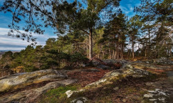
Popular Fontainebleau Mountain Biking Trails
• 75 ★ 5.0 • 2,001 ft • 25 ft • 58 •
The first official mtb trail in the Fontainebleau forest ! Create with the help of the french Moutain Biker Foundation (MBF), the french forest office (ONF) and the dérailleur bicycle association.
• 80 ★ 4.0 • 1,499 ft • 2 ft • 36 •
Rocks, roots, berms, gaps, and steep chutes, this short trail has everything!
• 90 ★ 4.0 • 879 ft • 0 ft • 30 •
A loamy part at the top and then some nice berms and big jumps!
• 55 ★ 0.0 • 1,972 ft • 6 ft • 26 •
Moderately popular green difficulty family friendly singletrack. This multi-use trail can be used both directions and has a easy overall physical rating with a 6 ft green climb. Trail visibility is always easy to follow. On average it takes 2 minutes to complete this trail.
• 100 ★ 0.0 • 909 ft • 0 ft • 26 •
Want some loam? There is some! Want so fast and loose section? There are some! Whant some jumps? There are some too!
• 95 ★ 0.0 • 2,201 ft • 15 ft • 24 •
Popular blue difficulty singletrack. This mountain bike primary trail can be used one direction.
• 25 ★ 4.5 • 2 miles • 28 ft • 24 •
Le plus beau sentier d'Île de France ! Vingt minutes de bonheur technique et ludique ! /// The most beautiful trail in the Paris Area ! Twenty minutes of technical and funny riding !
• 80 ★ 0.0 • 2,021 ft • 62 ft • 23 •
Popular blue difficulty singletrack. This mountain bike primary trail can be used one direction.
Fontainebleau Mountain Bike Routes
★ 5.0 • 5 miles • 362 ft • 7 • Loop •
The first official MTB trail in the Fontainebleau forest! Created with the help of the French Mountain...
★ 4.0 • 32 miles • 1,907 ft • 0 •
Super rando en VTT, beaux points de vues, belles descentes.
22 miles • 770 ft • 0 • Loop •
Rando en foret de fontainebleau
28 miles • 1,726 ft • 0 • Loop •
Linéaire vers Larchant - 16162 - UtagawaVTT.com
Photos of Fontainebleau Mountain Bike
Videos of Fontainebleau Mountain Bike
trail: Rock Hop de la Reine
0:14 |
513 |
Jan 19, 2020
Recent Trail Reports
| status | trail | date | condition | info | user |
|---|---|---|---|---|---|
| Flow Line | Jun 14, 2025 @ 9:58am Jun 14, 2025 | Dry | mcdog | ||
| La Complète | Jun 14, 2025 @ 9:58am Jun 14, 2025 | Dry | mcdog | ||
| Voie de Remontée | Jun 14, 2025 @ 9:58am Jun 14, 2025 | Dry | mcdog | ||
| La Fraiche | Jun 14, 2025 @ 9:58am Jun 14, 2025 | Dry | mcdog | ||
| Loamy and Loose | Jun 14, 2025 @ 9:58am Jun 14, 2025 | Dry | mcdog | ||
| Tic Et Tac | Jun 14, 2025 @ 9:58am Jun 14, 2025 | Dry | mcdog | ||
| Na Torfy A1 | Nov 9, 2023 @ 11:05pm Nov 9, 2023 | Ideal | ettore40 | ||
| MBF Part 1 | Jul 11, 2022 @ 8:19am Jul 11, 2022 | Dry | BiLKiNiS | ||
| Route du Calvaire | Jan 2, 2022 @ 5:31am Jan 2, 2022 | Variable | Eaz | ||
| Route des Hauteurs de la Solle | Sep 4, 2021 @ 3:38am Sep 4, 2021 | Ideal | Eaz |
Activity Feed
| username | action | type | title | date |
|---|---|---|---|---|
| davidmountainlove | wishlist | trail | activity #96288947 and 1 more | Jun 5, 2026 @ 5:44am Jun 5, 2026 |
| sachotf9wvg1 | ridden | trail | activity #94918151 | May 17, 2026 @ 10:22am May 17, 2026 |
| BertFrJ5P6 | wishlist | trail | activity #94346826 | May 9, 2026 @ 8:55am May 9, 2026 |
| Simonv1DkxT | wishlist | trail | activity #92654260 | Apr 15, 2026 @ 5:44am Apr 15, 2026 |
| afshinb | wishlist | trail | activity #92583561 | Apr 14, 2026 @ 1:04am Apr 14, 2026 |
Recent Comments
| username | type | title | comment | date |
|---|---|---|---|---|
| trail | Ce sentier est plutôt classé, rouge que bleu | Dec 27, 2025 @ 1:49am Dec 27, 2025 | ||
| trail | Un single très ludique, pas de grosses... | Nov 14, 2021 @ 2:25am Nov 14, 2021 | ||
| report | Thanks for the report. Keep it up! | Aug 9, 2020 @ 8:47am Aug 9, 2020 | ||
| trail | Great trail! Technical! | Jul 28, 2020 @ 10:37am Jul 28, 2020 | ||
| trail | C’est sympa mais bon je dirais pas que... | Jun 29, 2020 @ 9:32am Jun 29, 2020 |
Local Badges
-

Epic Mountain Bike Climb 2k1 awarded -

Climbing 10k Badge10 awarded -

Mountain Biking 100k Badge0 awarded -

Epic Ride Descent 2k1 awarded -

Descent 10k Badge10 awarded -

Descent 100k Badge0 awarded
Activity Type Stats
| activitytype | trails | distance | descent | descent distance | total vertical | rating | global rank | state rank | photos | reports | routes | ridelogs |
|---|---|---|---|---|---|---|---|---|---|---|---|---|
| Mountain Bike | 46 | 14 miles | 1,283 ft | 6 miles | 279 ft | #4,512 | #153 | 27 | 145 | 4 | 3,184 | |
| E-Bike | 46 | 14 miles | 1,283 ft | 6 miles | 279 ft | #2,957 | #170 | 127 | 2 | 138 | ||
| Horse | 12 | #645 | #30 | 24 | ||||||||
| Hike | 60 | 13 miles | 961 ft | 5 miles | 279 ft | #917 | #21 | 142 | 1 | 249 | ||
| Trail Running | 60 | 13 miles | 961 ft | 5 miles | 279 ft | #4,080 | #135 | 142 | 1 | 208 |
Frequently Asked Questions About Fontainebleau
▼
What are the best places to ride in Fontainebleau?
Fontainebleau has 1 areas to explore for mountain biking. The top rated areas are:
▼
What are the highest rated mountain biking trails in Fontainebleau?
The highest rated mountain biking trails in Fontainebleau are:
- MBF Part 1 (4.4/5)
- Rock Hop de la Reine (4.2/5)
- Balcon Mont Ussy (4.1/5)
- La Complète (4/5)
- La Fraiche (4/5)
▼
What is the best time of the year to ride in Fontainebleau?
Based on ride log data, the most popular months to ride in Fontainebleau are:
- December (17 activities)
- August (12 activities)
- January (12 activities)
▼
Where can I park to ride in Fontainebleau?
There are 18 parking locations listed in Fontainebleau. The most popular parking spots are: View all parking and trailhead locations on the map to plan your visit.
Activities
- By Adidot & contributors
- Admins: apply
- #15943 - 11,478 views
- fontainebleau activity log | embed map of Fontainebleau mountain bike trails | fontainebleau mountain biking points of interest polygons
Downloading of trail gps tracks in kml & gpx formats is enabled for Fontainebleau.
You must login to download files.