close
-
Layers w
- Weather Layers
- Pro
- Pro
- Pro
- Pro
- Pro
- Pro
- More Layers
- Pro
- Pro
- Pro
- Pro
-
Upgrade to

3D
Trail Conditions
- Unknown
- Snow Groomed
- Snow Packed
- Snow Covered
- Snow Cover Partial
- Freeze/thaw Cycle
- Icy
- Prevalent Mud
- Wet
- Variable
- Ideal
- Dry
- Very Dry
Trail Flow (Ridden Direction)
Trailforks scans users ridelogs to determine the most popular direction each trail is ridden. A good flowing trail network will have most trails flowing in a single direction according to their intension.
The colour categories are based on what percentage of riders are riding a trail in its intended direction.
The colour categories are based on what percentage of riders are riding a trail in its intended direction.
- > 96%
- > 90%
- > 80%
- > 70%
- > 50%
- < 50%
- bi-directional trail
- no data
Trail Last Ridden
Trailforks scans ridelogs to determine the last time a trail was ridden.
- < 2 days
- < 1 week
- < 2 weeks
- < 1 month
- < 6 months
- > 6 months
Trail Ridden Direction
The intended direction a trail should be ridden.
- Downhill Only
- Downhill Primary
- Both Directions
- Uphill Primary
- Uphill Only
- One Direction
Contribute Details
Colors indicate trail is missing specified detail.
- Description
- Photos
- Description & Photos
- Videos
Trail Popularity ?
Trailforks scans ridelogs to determine which trails are ridden the most in the last 9 months.
Trails are compared with nearby trails in the same city region with a possible 25 colour shades.
Think of this as a heatmap, more rides = more kinetic energy = warmer colors.
- most popular
- popular
- less popular
- not popular
ATV/ORV/OHV Filter
Max Vehicle Width
inches
US Cell Coverage
Legend

Radar Time
Activity Recordings
Trailforks uses anonymized public activity data.
?
Activity Recordings
Trailforks uses anonymized public activity data.
?
Personal Heatmap
▶
Activity Types
all
/
none
▶
Options
2
Date range
month
–
Winter Trails
Warning
A routing network for winter maps does not exist. Selecting trails using the winter trails layer has been disabled.
Missing Trails
Most Popular
Least Popular
Trails are colored based on popularity. The more popular a trail is, the more red. Less popular trails trend towards green.
Jump Magnitude Heatmap
Heatmap of where riders jump on trails. Zoom in to see individual jumps, click circles to view jump details.
BC Backroad Status
![map legend]()
Service Road Atlas is a free to use, community-driven service for viewing and creating reports on the numerous back-country service roads around B.C. and Alberta.

Slope Aspect
Direction the slope faces
Trails Deemphasized
Trails are shown in grey.
Only show trails with no bike usage.
Suggested Layers
Based on selected activity type
Save the current map location and zoom level as your default home location whenever this page is loaded.
Save
No description for Fort St. John has been added yet!
Login or register to submit one.
Activities Click to view
- Mountain Bike
33 trails
- Winter Fat Bike
0 trails
- Hike
100 trails
- Trail Running
100 trails
- Snowshoe
22 trails
- Backcountry Ski
12 trails
Region Details
- 1
- 11
- 18
- 3
Region Status
Caution as of May 5, 2026Stats
- Avg Trail Rating
- Global Ranking
- #3,981
- State Ranking
- #95
- Trails (view details)
- 37
- Trails Mountain Bike
- 34
- Trails E-Bike
- 2
- Trails Horse
- 1
- Trails Hike
- 100
- Trails Trail Running
- 100
- Trails Dirtbike/Moto
- 2
- Trails ATV/ORV/OHV
- 1
- Trails Snowmobile
- 1
- Trails Snowshoe
- 22
- Trails Backcountry Ski
- 12
- Trails Nordic Ski
- 1
- Total Distance
- 26 miles
- Total Descent
- 5,109 ft
- Total Vertical
- 1,267 ft
- Highest Trailhead
- 2,624 ft
- Reports
- 127
- Photos
- 104
- Ridden Counter
- 576
Sub Regions
-
Beatton Provincial Park
- 5
- 7
-
Beatton River
- 2
- 3
- 1
-
Big Bam
- 1
- 7
- 2
-
Charlie Lake Provincial Park
- 3
Popular Fort St. John Mountain Biking Trails
• 70 ★ 4.6 • 4,780 ft • 0 ft • 41 •
Flowy single track with many gap jumps, drops, a wall ride and other features. Girlfriend line for every feature.
• 90 ★ 5.0 • 4 miles • 865 ft • 30 •
Cactus Trails - Crown land - single track - windy, dips and drops
• 100 ★ 4.0 • 2 miles • 93 ft • 28 •
Newer section of trail that is less hilly and beginner friendly.
• 100 ★ 0.0 • 1 mile • 169 ft • 27 •
Popular green difficulty family friendly singletrack. This mountain bike primary trail can be used both directions and has a moderate overall physical rating with a 169 ft green climb. On average it takes 15 minutes to complete this trail.
• 90 ★ 0.0 • 1 mile • 243 ft • 16 •
Popular blue difficulty singletrack. This mountain bike primary trail can be used both directions.
• 80 ★ 4.0 • 2,959 ft • 209 ft • 15 •
Mostly open double track climb with one steep singletrack section in the middle.
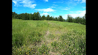
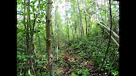
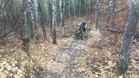
Photos of Fort St. John Mountain Bike
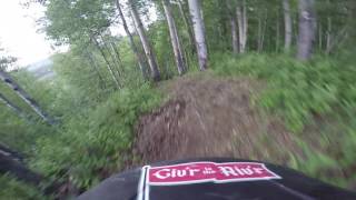
Videos of Fort St. John Mountain Bike
trail: In the Bush
2:42 |
100 |
Jul 19, 2020
trail: Voice of Resurgence
0:08 |
46 |
Jul 19, 2020
trail: Stinky Panties
0:09 |
531 |
Feb 6, 2019
trail: In the Bush
2:48 |
328 |
Jun 1, 2020 , Fort St. John

1115 |
Jun 8, 2016 , Fort St. John
Recent Trail Reports
| status | trail | date | condition | info | user |
|---|---|---|---|---|---|
| Cactus Trails | May 5, 2026 @ 7:11pm (America/Dawson_Creek) May 5, 2026 | Ideal | CShuman989 | ||
| Stinky Panties | Sep 16, 2025 @ 11:46pm (America/Vancouver) Sep 16, 2025 | Variable | thekidchef21 | ||
| Crooked Cat =^.^= | May 24, 2025 @ 12:07pm May 24, 2025 | Dry | Tony0Z9esB | ||
| Massey Ave | May 24, 2025 @ 12:07pm May 24, 2025 | Dry | Tony0Z9esB | ||
| Lake Loop | May 24, 2025 @ 12:07pm May 24, 2025 | Dry | Tony0Z9esB | ||
| Rhino | May 24, 2025 @ 12:07pm May 24, 2025 | Dry | Tony0Z9esB | ||
| Voice of Resurgence | Sep 16, 2024 @ 6:40pm Sep 16, 2024 | Dry | Hmwright | ||
| Life in the Loam Lane | Sep 16, 2024 @ 6:39pm Sep 16, 2024 | Dry | Hmwright | ||
| Benbow | Sep 13, 2022 @ 3:19pm Sep 13, 2022 | Variable | paulmackey | ||
| Beatton Provincial Park Snowshoe Trail | Sep 13, 2022 @ 3:19pm Sep 13, 2022 | Variable | paulmackey |
Activity Feed
| username | action | type | title | date |
|---|---|---|---|---|
| RonHNoVxr | wishlist | trail | activity #98247569 and 1 more | Jul 1, 2026 @ 10:08pm 10 hours |
| MarinaDivAJ5 | wishlist | trail | activity #96977441 | Jun 14, 2026 @ 9:23am Jun 14, 2026 |
| CShuman989 | add | report | activity #94131813 | May 5, 2026 @ 7:11pm May 5, 2026 |
| taprider | ridden | trail | activity #82094799 | Oct 10, 2025 @ 4:31pm Oct 10, 2025 |
| thekidchef21 | checkin | trail | activity #80516941 | Sep 16, 2025 @ 11:46pm Sep 16, 2025 |
Recent Comments
| username | type | title | comment | date |
|---|---|---|---|---|
| trail | Me and some buddies are going down next season... | Sep 16, 2025 @ 11:35pm Sep 16, 2025 | ||
| trail | Optional little loop in the same style as the... | Aug 11, 2025 @ 7:56am Aug 11, 2025 | ||
| trail | Very XC style riding, the east side is more... | Aug 11, 2025 @ 7:55am Aug 11, 2025 | ||
| trail | Features are falling apart or unridable. Not... | Aug 11, 2025 @ 7:51am Aug 11, 2025 | ||
| trail | Super cool trail and super flowy but easy for... | Aug 5, 2024 @ 1:41pm Aug 5, 2024 |
Local Badges
-

Epic Mountain Bike Climb 2k2 awarded -

Climbing 10k Badge5 awarded -

Mountain Biking 100k Badge0 awarded -

Epic Ride Descent 2k2 awarded -

Descent 10k Badge5 awarded -

Descent 100k Badge0 awarded
Bike & Skill Parks
| name | type | city | rating |
|---|---|---|---|
| Velosolutions Pump Track(s) | skill park | Fort St. John |
Activity Type Stats
| activitytype | trails | distance | descent | descent distance | total vertical | rating | global rank | state rank | photos | reports | routes | ridelogs |
|---|---|---|---|---|---|---|---|---|---|---|---|---|
| Mountain Bike | 33 | 23 miles | 4,528 ft | 10 miles | 1,266 ft | #3,981 | #95 | 104 | 127 | 1,919 | ||
| E-Bike | 2 | 5 miles | 873 ft | 2 miles | 1,053 ft | 101 | 79 | |||||
| Horse | 1 | 16 | ||||||||||
| Hike | 100 | 24 miles | 4,416 ft | 11 miles | 1,181 ft | #3,480 | #99 | 122 | 294 | |||
| Trail Running | 100 | 24 miles | 4,416 ft | 11 miles | 1,181 ft | #4,710 | #109 | 122 | 173 | |||
| Dirtbike/Moto | 2 | 13 | 15 | |||||||||
| ATV/ORV/OHV | 1 | 13 | ||||||||||
| Snowmobile | 1 | 1 | ||||||||||
| Snowshoe | 22 | 9 miles | 1,237 ft | 3 miles | 1,109 ft | #1,098 | #59 | 13 | 10 | |||
| Backcountry Ski | 12 | #647 | #37 | |||||||||
| Nordic Ski | 1 | 97 |
Frequently Asked Questions About Fort St. John
▼
What are the best places to ride in Fort St. John?
Fort St. John has 6 areas to explore for mountain biking. The top rated areas are:
▼
What are the highest rated mountain biking trails in Fort St. John?
The highest rated mountain biking trails in Fort St. John are:
- Stinky Panties (4.3/5)
- Rock on Shredderz! (4.2/5)
- Life in the Loam Lane (4.2/5)
- Cactus Trails (4.1/5)
- In the Bush (4.1/5)
▼
What is the best time of the year to ride in Fort St. John?
Based on ride log data, the most popular months to ride in Fort St. John are:
- May (16 activities)
- June (15 activities)
- August (14 activities)
▼
Where can I park to ride in Fort St. John?
Activities
Trails
- By gjwiebe
 FSJMTB & contributors
 - Admins: BCBR, TrailsBC, BCORMA, DSBC, wheelmaniac3, bcpunk, NBC, PGBRS, aleksa, FSJMTB
- #8593 - 10,391 views
- fort st. john activity log | embed map of Fort St. John mountain bike trails | fort st. john mountain biking points of interest
Downloading of trail gps tracks in kml & gpx formats is enabled for Fort St. John.
You must login to download files.