close
-
Layers w
- Weather Layers
- Pro
- Pro
- Pro
- Pro
- Pro
- Pro
- More Layers
- Pro
- Pro
- Pro
- Pro
-
Upgrade to

3D
Trail Conditions
- Unknown
- Snow Groomed
- Snow Packed
- Snow Covered
- Snow Cover Partial
- Freeze/thaw Cycle
- Icy
- Prevalent Mud
- Wet
- Variable
- Ideal
- Dry
- Very Dry
Trail Flow (Ridden Direction)
Trailforks scans users ridelogs to determine the most popular direction each trail is ridden. A good flowing trail network will have most trails flowing in a single direction according to their intension.
The colour categories are based on what percentage of riders are riding a trail in its intended direction.
The colour categories are based on what percentage of riders are riding a trail in its intended direction.
- > 96%
- > 90%
- > 80%
- > 70%
- > 50%
- < 50%
- bi-directional trail
- no data
Trail Last Ridden
Trailforks scans ridelogs to determine the last time a trail was ridden.
- < 2 days
- < 1 week
- < 2 weeks
- < 1 month
- < 6 months
- > 6 months
Trail Ridden Direction
The intended direction a trail should be ridden.
- Downhill Only
- Downhill Primary
- Both Directions
- Uphill Primary
- Uphill Only
- One Direction
Contribute Details
Colors indicate trail is missing specified detail.
- Description
- Photos
- Description & Photos
- Videos
Trail Popularity ?
Trailforks scans ridelogs to determine which trails are ridden the most in the last 9 months.
Trails are compared with nearby trails in the same city region with a possible 25 colour shades.
Think of this as a heatmap, more rides = more kinetic energy = warmer colors.
- most popular
- popular
- less popular
- not popular
ATV/ORV/OHV Filter
Max Vehicle Width
inches
US Cell Coverage
Legend

Radar Time
Activity Recordings
Trailforks uses anonymized public activity data.
?
Activity Recordings
Trailforks uses anonymized public activity data.
?
Personal Heatmap
▶
Activity Types
all
/
none
▶
Options
2
Date range
month
–
Winter Trails
Warning
A routing network for winter maps does not exist. Selecting trails using the winter trails layer has been disabled.
Missing Trails
Most Popular
Least Popular
Trails are colored based on popularity. The more popular a trail is, the more red. Less popular trails trend towards green.
Jump Magnitude Heatmap
Heatmap of where riders jump on trails. Zoom in to see individual jumps, click circles to view jump details.
BC Backroad Status
![map legend]()
Service Road Atlas is a free to use, community-driven service for viewing and creating reports on the numerous back-country service roads around B.C. and Alberta.

Slope Aspect
Direction the slope faces
Trails Deemphasized
Trails are shown in grey.
Only show trails with no bike usage.
Suggested Layers
Based on selected activity type
Save the current map location and zoom level as your default home location whenever this page is loaded.
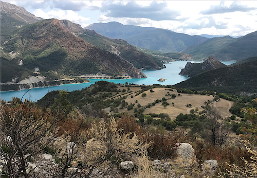
SavePlace to ride, all the valley have some technicals trails and awesome wild singles!
Links
This region uses the Uk/Euro style trail grading system.
Stats
- Avg Trail Rating
- Trails (view details)
- 37,311
- Trails Mountain Bike
- 30,387
- Trails E-Bike
- 26,523
- Trails Gravel Bike
- 11,350
- Trails Adaptive Bike
- 3,683
- Trails Winter Fat Bike
- 828
- Trails Horse
- 1,538
- Trails Hike
- 25,266
- Trails Trail Running
- 25,080
- Trails Dirtbike/Moto
- 731
- Trails Observed Trials
- 571
- Trails ATV/ORV/OHV
- 566
- Trails Snowmobile
- 63
- Trails Snowshoe
- 171
- Trails Downhill Ski
- 6,357
- Trails Backcountry Ski
- 258
- Trails Nordic Ski
- 258
- Total Distance
- 32,843 miles
- Total Descent
- 2,494 miles
- Total Vertical
- 15,183 ft
- Highest Trailhead
- 15,184 ft
- Reports
- 70,178
- Photos
- 24,360
- Ridden Counter
- 1,330,235
Articles
Video: 72 Hours in Loudenvielle | PRT heads to Round 1 of the UCI Enduro World Cup
Jun 3, 2026 from pinkbike.com
The Priority Racing Team silences the critics as Lief Rodgers and Evan Wall storm into the Top 15 on their high-pivot, chainless rigs.

30% Of Racers Hit The Deck | Story Of The Race | Loudenvielle DH World Cup 2026
Jun 1, 2026 from pinkbike.com
Ben Cathro fires up the ghost machine to compare lines, analyze massive mistakes, and break down a historic Round 2 of the Downhill World Cup.
Video: Measuring the Loudenvielle DH Gaps During Track Walk
May 28, 2026 from pinkbike.com
It's time to get the tape measure out.
Tech Video: A Deep Dive into Antidote’s Insane Telemetry-Backed Gearbox DH Bike | Loudenvielle DH World Cup
May 28, 2026 from pinkbike.com
We corner the designers at Antidote Solutions to figure out the methodology behind their telemetry-heavy, high-pivot World Cup downhill monster.
Popular Trail Networks
view all areas »Sub Regions
- Auvergne - Rhône-Alpes (9,887)
- Bourgogne-Franche-Comté (731)
- Bretagne (130)
- Centre-Val de Loire (35)
- Corse (187)
- Grand Est (1,602)
- Guadeloupe (0)
- Hauts de France (49)
- Île-de-France (723)
- La Réunion (33)
- New Caledonia (54)
- Normandie (287)
- Nouvelle-Aquitaine (830)
- Occitanie (5,585)
- Pays de la Loire (76)
- Polynesie (15)
- Provence-Alpes-Côte d'Azur (10,227)
Popular France Mountain Biking Trails
• 90 ★ 4.7 • 4,865 ft • 2 ft • 2,891 •
Flowy classic "bike park" trail with lots of berms and jumps, including the infamous "Grosse Berth". Possibility to miss the jumps if necessary
• 95 ★ 4.6 • 1 mile • 0 ft • 2,849 •
is one of the most popular trails on Super Morzine. It is a machine made track so is nice and wide and full of banked turns. There are also a few tabletop jumps which are great to learn on. There are no technical features to this trail,...
• 100 ★ 4.2 • 1,808 ft • 0 ft • 2,771 •
Two straight lines, one with rollers and the other with tables (with optional bigger lips) that then lead into large berms linked with optional gap jumps.
• 100 ★ 4.6 • 1 mile • 0 ft • 2,658 •
Super fun and flowy green track that takes you from the chairlift to the depart of the Serrausaix chairlift. Filled with rollers, tabletop jumps and bermed corners.
• 75 ★ 3.2 • 5,112 ft • 32 ft • 2,621 •
This track takes you from the top ridge line between Chatel and Lindarets, down into the Lindarets valley. Here you'll find a number of restaurants as well as a bike wash. The track is very easy to ride with banked corners and some...
• 95 ★ 4.0 • 4 miles • 144 ft • 2,478 •
Trail to return to Morzine, partly asphalt (watch for cars) with a short climb.
France Mountain Bike Routes
★ 5.0 • 12 miles • 925 ft • 3 •
La "Dégage-à-Moûtiers!" c'est l'itinéraire entier du sommet St Martin Express jusqu'à Moûtiers !...
★ 5.0 • 7 miles • 1,624 ft • 1 • Loop •
Premier sentier "historique" dédiée à la pratique de l'enduro ouvert par les locaux. Vous allez...
★ 5.0 • 6 miles • 1,285 ft • 4 • Loop •
A loop starting from D122, just outside Archail. Drop into for access and ride up the fire road climb for...
★ 5.0 • 10 miles • 2,729 ft • 4 • Loop •
D’anciens sentiers et des nouveautés sont au menu de cet itinéraire Enduro rouge composé de deux...
★ 4.4 • 10 miles • 2,724 ft • 2 • Loop •
Circuits enduro balisé E22. D’anciens sentiers et des nouveautés sont au menu de cet itinéraire...
★ 5.0 • 24 miles • 3,934 ft • 11 • Loop •
Trace 40km de l'édition 2019 de la Randonnée vtt du Rove organisée par le club local. Parcours...
Photos of France Mountain Bike
Videos of France Mountain Bike
featured
![Rendez-vous sur les pistes du Bike Park]()

trail: La Grenèche
0:11 |
204 |
Jun 11, 2024 , La Clusaz
featured
![Nouvelle piste sur le Bike Park - DH du Loup]()
trail: La Descente Du Loup
0:46 |
476 |
Jul 26, 2022 , La Clusaz
featured
![MTB Enduro in Marseille Niolon 2019]()
trail: Jonquier DH
4:37 |
963 |
May 4, 2019 , Le Rove
trail: Mouralex
0:31 |
|
Jun 20, 2026
trail: Sentier Sur Le Feu
0:11 |
1 |
Jun 15, 2026
trail: Retour Morzine
3:02 |
26 |
Jun 7, 2026
trail: Matrasse
0:22 |
8 |
Jun 2, 2026
trail: Liaison Vallon de Braus
0:03 |
10 |
May 1, 2026
National Scenic Trails & Official Routes
-
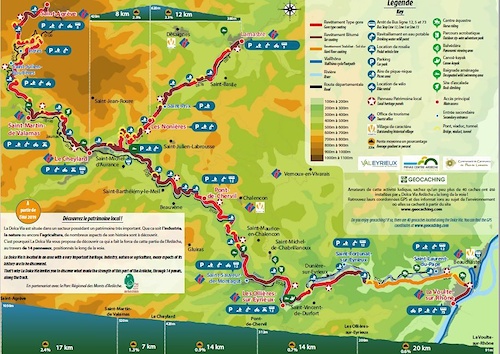
DOLCE VIA
- Mountain Bike
- E-Bike
- Hike
- Trail Running
-
Grande Traversée VTT Alpes-Provence
- Mountain Bike
- E-Bike
-
Grande Traversée VTT des Préalpes - Les Chemins du Soleil
- Mountain Bike
- E-Bike
-
Grande Traversée VTT du Massif Central
- Mountain Bike
- E-Bike
Recent Comments
| username | type | title | comment | date |
|---|---|---|---|---|
| trail | Quel est son état, ça passe ? vu qu'il y a... | Jun 21, 2026 @ 5:01am 1 hours | ||
| trail | Definitely some sections that wouldn’t be... | Jun 19, 2026 @ 1:22pm 2 days | ||
| trail | Not rideable at all! Delete it! It doesn't exist! | Jun 19, 2026 @ 8:22am 2 days | ||
| trail | Jolie descente sympa, à part la végétation... | Jun 19, 2026 @ 7:38am 2 days | ||
| trail | Sentier complètement refermé par la... | Jun 18, 2026 @ 5:15am Jun 18, 2026 |
Bike & Skill Parks
| name | type | city | rating |
|---|---|---|---|
| Les Gets Bike Park | bike park | Les Gets | |
| Alpe d'Huez Bike Park | bike park | Alpe d'Huez | |
| Chatel Bike Park | bike park | Chatel | |
| Les 2 Alpes Bike Park | bike park | Les Deux Alpes | |
| Morzine Bikepark | bike park | Morzine |
Upcoming Local Events
Activity Type Stats
| activitytype | trails | distance | descent | descent distance | total vertical | rating | global rank | state rank | photos | reports | routes | ridelogs |
|---|---|---|---|---|---|---|---|---|---|---|---|---|
| Mountain Bike | 30,387 | 28,317 miles | 1,831 miles | 15,526 miles | 11,942 ft | #7 | 23,460 | 70,009 | 1,617 | 1,004,037 | ||
| E-Bike | 26,523 | 24,648 miles | 1,617 miles | 13,574 miles | 10,827 ft | #5 | 246 | 65,208 | 877 | 139,550 | ||
| Gravel Bike | 11,350 | 13,896 miles | 1,615,433 ft | 4,810 miles | 11,608 ft | #4 | 3,353 | 114 | 10,299 | |||
| Adaptive Bike | 3,683 | 4,976 miles | 496,211 ft | 1,564 miles | 8,944 ft | #6 | 8,581 | 8 | 7 | |||
| Winter Fat Bike | 828 | 1,116 miles | 176,686 ft | 495 miles | 9,117 ft | #9 | 2,578 | 1 | 10 | |||
| Horse | 1,538 | 1,703 miles | 272,687 ft | 673 miles | 9,898 ft | #7 | 9,232 | 2 | 45 | |||
| Hike | 25,265 | 25,095 miles | 1,479 miles | 13,078 miles | 11,942 ft | #6 | 158 | 64,447 | 145 | 84,181 | ||
| Trail Running | 25,079 | 24,925 miles | 1,465 miles | 12,977 miles | 11,942 ft | #6 | 10 | 64,455 | 127 | 51,285 | ||
| Dirtbike/Moto | 731 | 822 miles | 101,345 ft | 304 miles | 9,101 ft | #7 | 7,831 | 3 | 115 | |||
| Observed Trials | 571 | 569 miles | 83,809 ft | 231 miles | 8,301 ft | #6 | 126 | 1 | 24 | |||
| ATV/ORV/OHV | 566 | 627 miles | 73,386 ft | 227 miles | 9,078 ft | #6 | 7,825 | 3 | 32 | |||
| Snowmobile | 63 | 47 miles | 10,377 ft | 23 miles | 8,009 ft | #8 | 547 | 5 | ||||
| Snowshoe | 171 | 179 miles | 49,977 ft | 85 miles | 9,695 ft | #5 | 1 | 995 | 8 | 1,449 | ||
| Downhill Ski | 6,357 | 3,554 miles | 3,153,524 ft | 3,336 miles | 12,060 ft | #2 | 8 | 429 | 1 | 62,712 | ||
| Backcountry Ski | 258 | 363 miles | 184,216 ft | 196 miles | 15,144 ft | #5 | 1 | 473 | 9 | 23,993 | ||
| Nordic Ski | 258 | 228 miles | 47,356 ft | 105 miles | 9,695 ft | #5 | 1 | 630 | 3 | 11,430 |
Activities
- France Mountain Biking Trails
- France E-Biking Trails
- France Gravel Biking Trails
- France Adaptive Biking Trails
- France Winter Fat Biking Trails
- France Horseback Trails
- France Hiking Trails
- France Trail Running Trails
- France Dirtbiking Trails
- France Observed Trials Trails
- France ATVing/Offroading Trails
- France Snowmobiling Trails
- France Snowshoeing Trails
- France Skiing Trails
- France Backcountry Skiing Trails
- France Nordic Skiing Trails
Trails
Points of Interest
- Drop LPT TTF
- La Ferme Des Boissets Sight
- Vultures view point Viewpoint
- Point Sublime Viewpoint
- Point de vue des falaises des gorges de Chateaudouble Viewpoint
- Very Steep and Rocky Section TTF
- Castel Diol Viewpoint
- Drop de la Yaya TTF
- Drop Lower secrete TTF
- Saut de la ligne TTF
- Mont Blanc - Monte Bianco (4,606 m)
- Petite Bosse (4,515 m)
- Grande Bosse (4,492 m)
- By canadaka
 Trailforks & contributors
 - Admins: TFFRANCE, elyari, freerider48, provencemb
- #3201 - 170,709 views
- france activity log | embed map of France mountain bike trails | france mountain biking points of interest polygons
Downloading of trail gps tracks in kml & gpx formats is enabled for France.
You must login to download files.