close
-
Layers w
- Weather Layers
- Pro
- Pro
- Pro
- Pro
- Pro
- Pro
- More Layers
- Pro
- Pro
- Pro
- Pro
-
Upgrade to

3D
Trail Conditions
- Unknown
- Snow Groomed
- Snow Packed
- Snow Covered
- Snow Cover Partial
- Freeze/thaw Cycle
- Icy
- Prevalent Mud
- Wet
- Variable
- Ideal
- Dry
- Very Dry
Trail Flow (Ridden Direction)
Trailforks scans users ridelogs to determine the most popular direction each trail is ridden. A good flowing trail network will have most trails flowing in a single direction according to their intension.
The colour categories are based on what percentage of riders are riding a trail in its intended direction.
The colour categories are based on what percentage of riders are riding a trail in its intended direction.
- > 96%
- > 90%
- > 80%
- > 70%
- > 50%
- < 50%
- bi-directional trail
- no data
Trail Last Ridden
Trailforks scans ridelogs to determine the last time a trail was ridden.
- < 2 days
- < 1 week
- < 2 weeks
- < 1 month
- < 6 months
- > 6 months
Trail Ridden Direction
The intended direction a trail should be ridden.
- Downhill Only
- Downhill Primary
- Both Directions
- Uphill Primary
- Uphill Only
- One Direction
Contribute Details
Colors indicate trail is missing specified detail.
- Description
- Photos
- Description & Photos
- Videos
Trail Popularity ?
Trailforks scans ridelogs to determine which trails are ridden the most in the last 9 months.
Trails are compared with nearby trails in the same city region with a possible 25 colour shades.
Think of this as a heatmap, more rides = more kinetic energy = warmer colors.
- most popular
- popular
- less popular
- not popular
ATV/ORV/OHV Filter
Max Vehicle Width
inches
US Cell Coverage
Legend

Radar Time
Activity Recordings
Trailforks uses anonymized public activity data.
?
Activity Recordings
Trailforks uses anonymized public activity data.
?
Personal Heatmap
▶
Activity Types
all
/
none
▶
Options
2
Date range
month
–
Winter Trails
Warning
A routing network for winter maps does not exist. Selecting trails using the winter trails layer has been disabled.
Missing Trails
Most Popular
Least Popular
Trails are colored based on popularity. The more popular a trail is, the more red. Less popular trails trend towards green.
Jump Magnitude Heatmap
Heatmap of where riders jump on trails. Zoom in to see individual jumps, click circles to view jump details.
BC Backroad Status
![map legend]()
Service Road Atlas is a free to use, community-driven service for viewing and creating reports on the numerous back-country service roads around B.C. and Alberta.

Slope Aspect
Direction the slope faces
Trails Deemphasized
Trails are shown in grey.
Only show trails with no bike usage.
Suggested Layers
Based on selected activity type
Save the current map location and zoom level as your default home location whenever this page is loaded.
Save
No description for Franconia has been added yet!
Login or register to submit one.
Activities Click to view
- Mountain Bike
87 trails
- E-Bike
53 trails
- Gravel Bike
0 trails
- Adaptive Bike
0 trails
- Horse
8 trails
- Hike
133 trails
- Trail Running
131 trails
- Dirtbike/Moto
8 trails
- Observed Trials
7 trails
- ATV/ORV/OHV
8 trails
- Snowmobile
0 trails
- Snowshoe
1 trails
- Downhill Ski
103 trails
- Backcountry Ski
0 trails
- Nordic Ski
37 trails
Region Details
- 21
- 24
- 29
- 12
- 1
Region Status
Open as of May 18, 2026Stats
- Avg Trail Rating
- Trails (view details)
- 260
- Trails Mountain Bike
- 87
- Trails E-Bike
- 53
- Trails Horse
- 8
- Trails Hike
- 133
- Trails Trail Running
- 131
- Trails Dirtbike/Moto
- 8
- Trails Observed Trials
- 7
- Trails ATV/ORV/OHV
- 8
- Trails Snowshoe
- 1
- Trails Downhill Ski
- 103
- Trails Nordic Ski
- 37
- Total Distance
- 142 miles
- Total Descent Distance
- 66 miles
- Total Descent
- 41,123 ft
- Total Vertical
- 3,149 ft
- Highest Trailhead
- 4,064 ft
- Reports
- 325
- Photos
- 64
- Ridden Counter
- 32,219
Sub Regions
-
Cannon Mountain
- 1
- 3
- 1
-
Franconia AREA NEMBA Trail Network
- 20
- 26
- 9
-
Franconia Notch State Park
- 4
- 2
-
Kinsman Ridge
- 2
Popular Franconia Mountain Biking Trails
• 90 ★ 5.0 • 5 miles • 390 ft • 334 •
This paved trail parallels the Parkway. The 14-mile round-trip brings riders within easy reach of park attractions, including , Cannon Cliff, Profile Lake, , The Aerial Tramway, and Echo Lake.
• 95 ★ 0.0 • 4 miles • 478 ft • 326 •
Popular green difficulty family friendly paved path. This multi-use trail can be used both directions and has a easy overall physical rating with a 478 ft green climb. Trail visibility is always easy to follow. On average it takes 31 minutes to complete this trail.
• 100 ★ 5.0 • 1,965 ft • 55 ft • 302 •
Ians trail, named after a local kid who loved to play out side. links you from the into the and Franconia Inn trails.
• 100 ★ 0.0 • 738 ft • 12 ft • 249 •
Popular green difficulty singletrack. This multi-use trail can be used both directions. On average it takes 1 minutes to complete this trail.
• 100 ★ 5.0 • 2,936 ft • 6 ft • 246 •
Popular blue difficulty singletrack. This multi-use trail can be used both directions. On average it takes 6 minutes to complete this trail.
• 95 ★ 5.0 • 4,311 ft • 16 ft • 242 •
Flowy single track branching off coming from Fox Hill and leading down to Airport via .
• 95 ★ 5.0 • 1,975 ft • 112 ft • 242 •
Popular blue difficulty singletrack. This multi-use trail can be used both directions. On average it takes 6 minutes to complete this trail.
Franconia Mountain Bike Routes
9 miles • 760 ft • 10 • Loop •
A route for the 2024 North Country Tricycle Poker Run.
★ 1.0 • 12 miles • 1,730 ft • 13 •
Fun 12 mile loop, includes some of Franconia's oldest and most technical trails.
22 miles • 2,046 ft • 0 •
Gravel and pavement mix. Starting and ending at Iron Furnace Brewery
Photos of Franconia Mountain Bike
Videos of Franconia Mountain Bike
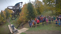
trail: Peepers
4:24 |
4261 |
Nov 20, 2018
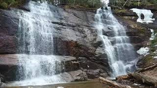
trail: Bridesmaids Falls Trail
0:36 |
308 |
Nov 20, 2022 , Franconia
Recent Trail Reports
| status | trail | date | condition | info | user |
|---|---|---|---|---|---|
| Dr No | May 18, 2026 @ 3:40pm (America/New_York) May 18, 2026 | Variable | jenkinsbikeshop | ||
| Birch Run | May 11, 2026 @ 7:55am (America/New_York) May 11, 2026 | Wet | Ralbert | ||
| Rough Cut | May 11, 2026 @ 7:07am (America/New_York) May 11, 2026 | Ideal | Ralbert | ||
| Rough Cut (Lower) | May 11, 2026 @ 7:07am (America/New_York) May 11, 2026 | Ideal | Ralbert | ||
| Neville's Turn | Feb 13, 2026 @ 4:06pm (America/New_York) Feb 13, 2026 | Ideal | EdwinNasonnRh FA NEMBA | ||
| Neville's Ridge Run | Feb 13, 2026 @ 4:06pm (America/New_York) Feb 13, 2026 | Snow Groomed | EdwinNasonnRh FA NEMBA | ||
| Ian's Trail | Feb 13, 2026 @ 4:06pm (America/New_York) Feb 13, 2026 | Snow Groomed | EdwinNasonnRh FA NEMBA | ||
| Lawrence Trail | Feb 13, 2026 @ 4:06pm (America/New_York) Feb 13, 2026 | Snow Groomed | EdwinNasonnRh FA NEMBA | ||
| Charlie's | Feb 13, 2026 @ 4:06pm (America/New_York) Feb 13, 2026 | Snow Groomed | EdwinNasonnRh FA NEMBA | ||
| Mojo Flow | Feb 13, 2026 @ 4:06pm (America/New_York) Feb 13, 2026 | Snow Cover Partial | EdwinNasonnRh FA NEMBA |
Activity Feed
| username | action | type | title | date |
|---|---|---|---|---|
| CHRISOHHHNU | wishlist | trail | activity #97097041 | Jun 16, 2026 @ 3:24am 2 days |
| Gleasons94 | wishlist | region | activity #96953287 | Jun 14, 2026 @ 4:10am Jun 14, 2026 |
| BrandiqZrrgq | ridden | trail | activity #96911488 | Jun 13, 2026 @ 1:28pm Jun 13, 2026 |
| PatricksQbSAt | add | photo | activity #96056255 | Jun 1, 2026 @ 6:48pm Jun 1, 2026 |
| Cielo | wishlist | route | activity #95483905 | May 25, 2026 @ 6:42am May 25, 2026 |
Recent Comments
| username | type | title | comment | date |
|---|---|---|---|---|
| trail | We did this in the opposite direction - i.e.... | May 11, 2026 @ 4:12am May 11, 2026 | ||
| trail | Harder than some of the trails in the northern... | May 11, 2026 @ 4:11am May 11, 2026 | ||
| trail | This is a great trail! Fast, flowy, a little... | May 11, 2026 @ 4:10am May 11, 2026 | ||
| trail | This trail was awesome - in the reverse... | May 11, 2026 @ 4:09am May 11, 2026 | ||
| trail | Sign behind new house says trail is closed by... | May 24, 2025 @ 3:24pm May 24, 2025 |
Local Badges
-

Completionist0 awarded -

Epic Ride Climb 2k41 awarded -

Climbing 10k Badge17 awarded -

Climbing 100k Badge0 awarded -

Epic Ride Descent 2k41 awarded -

Descent 10k Badge18 awarded
Activity Type Stats
| activitytype | trails | distance | descent | descent distance | total vertical | rating | global rank | state rank | photos | reports | routes | ridelogs |
|---|---|---|---|---|---|---|---|---|---|---|---|---|
| Mountain Bike | 87 | 48 miles | 6,099 ft | 20 miles | 1,155 ft | #2,569 | #922 | 46 | 289 | 4 | 5,251 | |
| E-Bike | 53 | 32 miles | 4,219 ft | 14 miles | 1,155 ft | #3,579 | #1,242 | 267 | 1 | 273 | ||
| Horse | 8 | 4,692 ft | 75 ft | 2,270 ft | 981 ft | #2,989 | #1,685 | 18 | ||||
| Hike | 133 | 98 miles | 17,972 ft | 38 miles | 3,150 ft | #1,137 | #526 | 19 | 292 | 2 | 4,105 | |
| Trail Running | 131 | 97 miles | 17,621 ft | 37 miles | 3,150 ft | #1,777 | #590 | 291 | 499 | |||
| Dirtbike/Moto | 8 | 4,692 ft | 75 ft | 2,270 ft | 981 ft | #1,185 | #475 | 18 | 2 | |||
| Observed Trials | 7 | 4,137 ft | 69 ft | 1,768 ft | 981 ft | #222 | #47 | 1 | 7 | |||
| ATV/ORV/OHV | 8 | 4,692 ft | 75 ft | 2,270 ft | 981 ft | #898 | #413 | 18 | 2 | |||
| Snowshoe | 1 | #968 | #473 | 70 | 93 | |||||||
| Downhill Ski | 103 | 25 miles | 21,401 ft | 21 miles | 2,149 ft | #112 | #49 | 33 | 3,293 | |||
| Nordic Ski | 37 | 22 miles | 2,087 ft | 9 miles | 837 ft | #572 | #187 | 53 | 278 |
Frequently Asked Questions About Franconia
▼
What are the best places to ride in Franconia?
Franconia has 6 areas to explore for mountain biking. The top rated areas are:
▼
What are the highest rated mountain biking trails in Franconia?
The highest rated mountain biking trails in Franconia are:
- Rough Cut (4.4/5)
- Red Flyer (4.3/5)
- Holy Moley (4.3/5)
- Ian's Trail (4.2/5)
- Neville's Ridge Run (4.2/5)
▼
What is the best time of the year to ride in Franconia?
Based on ride log data, the most popular months to ride in Franconia are:
- July (140 activities)
- August (110 activities)
- June (72 activities)
▼
Where can I park to ride in Franconia?
There are 24 parking locations listed in Franconia. The most popular parking spots are:
- Lonesome Lake Trailhead Parking
- Lafayette Place East Parking
- Lafayette West Parking
- Old Country Road Parking
- Parking
Activities
Trails
Points of Interest
- The Cannon Balls Summit
- Cannon Balls West Summit
- West Wind Vacation Cottages Cabin
- Hillwinds Lodge
- Stoneybrook Motel & Lodge
- Iron Furnace Brewing Sight
- Scrag Hill Summit
- Northeast Cannon Ball Summit
- Bridesmaind's Falls Sight
- Bald Peak Summit
- Cannon Mountain (4,078 ft)
- The Cannon Balls East (3,763 ft)
- The Cannonballs West (3,688 ft)
- By elchomator
 & contributors
 - Admins: FA NEMBA, WMNEMBA, CNH NEMBA, MRTC, UWV
- #7302 - 11,864 views
- franconia activity log | embed map of Franconia mountain bike trails | franconia mountain biking points of interest
Downloading of trail gps tracks in kml & gpx formats is enabled for Franconia.
You must login to download files.