close
-
Layers w
- Weather Layers
- Pro
- Pro
- Pro
- Pro
- Pro
- Pro
- More Layers
- Pro
- Pro
- Pro
- Pro
-
Upgrade to

3D
Trail Conditions
- Unknown
- Snow Groomed
- Snow Packed
- Snow Covered
- Snow Cover Partial
- Freeze/thaw Cycle
- Icy
- Prevalent Mud
- Wet
- Variable
- Ideal
- Dry
- Very Dry
Trail Flow (Ridden Direction)
Trailforks scans users ridelogs to determine the most popular direction each trail is ridden. A good flowing trail network will have most trails flowing in a single direction according to their intension.
The colour categories are based on what percentage of riders are riding a trail in its intended direction.
The colour categories are based on what percentage of riders are riding a trail in its intended direction.
- > 96%
- > 90%
- > 80%
- > 70%
- > 50%
- < 50%
- bi-directional trail
- no data
Trail Last Ridden
Trailforks scans ridelogs to determine the last time a trail was ridden.
- < 2 days
- < 1 week
- < 2 weeks
- < 1 month
- < 6 months
- > 6 months
Trail Ridden Direction
The intended direction a trail should be ridden.
- Downhill Only
- Downhill Primary
- Both Directions
- Uphill Primary
- Uphill Only
- One Direction
Contribute Details
Colors indicate trail is missing specified detail.
- Description
- Photos
- Description & Photos
- Videos
Trail Popularity ?
Trailforks scans ridelogs to determine which trails are ridden the most in the last 9 months.
Trails are compared with nearby trails in the same city region with a possible 25 colour shades.
Think of this as a heatmap, more rides = more kinetic energy = warmer colors.
- most popular
- popular
- less popular
- not popular
ATV/ORV/OHV Filter
Max Vehicle Width
inches
US Cell Coverage
Legend

Radar Time
Activity Recordings
Trailforks uses anonymized public activity data.
?
Activity Recordings
Trailforks uses anonymized public activity data.
?
Personal Heatmap
▶
Activity Types
all
/
none
▶
Options
2
Date range
month
–
Winter Trails
Warning
A routing network for winter maps does not exist. Selecting trails using the winter trails layer has been disabled.
Missing Trails
Most Popular
Least Popular
Trails are colored based on popularity. The more popular a trail is, the more red. Less popular trails trend towards green.
Jump Magnitude Heatmap
Heatmap of where riders jump on trails. Zoom in to see individual jumps, click circles to view jump details.
BC Backroad Status
![map legend]()
Service Road Atlas is a free to use, community-driven service for viewing and creating reports on the numerous back-country service roads around B.C. and Alberta.

Slope Aspect
Direction the slope faces
Trails Deemphasized
Trails are shown in grey.
Only show trails with no bike usage.
Suggested Layers
Based on selected activity type
Save the current map location and zoom level as your default home location whenever this page is loaded.
Save
No description for Fruitvale has been added yet!
Login or register to submit one.
Activities Click to view
- Mountain Bike
3 trails
- Winter Fat Bike
0 trails
- Hike
2 trails
- Trail Running
2 trails
Region Details
- 2
- 1
Region Status
Open as of Jun 6, 2026Stats
- Avg Trail Rating
- Trails (view details)
- 3
- Trails Mountain Bike
- 3
- Trails E-Bike
- 2
- Trails Hike
- 2
- Trails Trail Running
- 2
- Total Distance
- 5 miles
- Total Descent
- 2,682 ft
- Total Vertical
- 1,772 ft
- Highest Trailhead
- 3,904 ft
- Reports
- 392
- Photos
- 44
- Ridden Counter
- 556
Popular Fruitvale Mountain Biking Trails
• 100 ★ 5.0 • 2 miles • 29 ft • 183 •
A new (as of June 2023) purpose-built dedicated downhill mountain bike trail, Smooth, flowing, pumping, poppy, bermed goodness. Funded by Beaver Valley Recreation and the Columbia Basin Trust, and constructed by Alpine Connection and...
• 80 ★ 4.4 • 1 mile • 747 ft • 168 •
The trail is a brand new, purpose built, multi-use trail, the first of its type in the Beaver Valley. It's an energetic climb winding through a beautiful mature forest, followed by a smooth flowing descent back down.
Photos of Fruitvale Mountain Bike
Videos of Fruitvale Mountain Bike
youtuber
![Barclay Creek - Fruitvale, BC]()
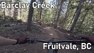
trail: Barclay Creek
8:34 |
104 |
Jul 22, 2025 , Fruitvale
Recent Trail Reports
| status | trail | date | condition | info | user |
|---|---|---|---|---|---|
| Webster Road | May 1, 2026 @ 8:28am (America/Vancouver) May 1, 2026 | Very Dry | Recchi | ||
| Barclay Creek | Apr 24, 2026 @ 8:51am (America/Vancouver) Apr 24, 2026 | Ideal | stewspooner KCTS | ||
| Webster Connector | Apr 24, 2026 @ 8:51am (America/Vancouver) Apr 24, 2026 | Ideal | stewspooner KCTS |
Activity Feed
| username | action | type | title | date |
|---|---|---|---|---|
| Becky821 | ridden | trail | activity #96717514 | Jun 10, 2026 @ 9:18pm Jun 10, 2026 |
| FrancoiskoXPmr | wishlist | trail | activity #96241759 | Jun 4, 2026 @ 11:27am Jun 4, 2026 |
| ceil56 | wishlist | trail | activity #94609853 | May 12, 2026 @ 11:04pm May 12, 2026 |
| Recchi | add | report | activity #93794957 | May 1, 2026 @ 10:21am May 1, 2026 |
| stewspooner | add | report | activity #93284567 and 2 more | Apr 24, 2026 @ 8:52am Apr 24, 2026 |
Recent Comments
| username | type | title | comment | date |
|---|---|---|---|---|
| trail | This should be called Fruitloops!! | Dec 22, 2025 @ 2:20pm Dec 22, 2025 | ||
| trail | A great flowing downhill with some technical... | Jul 7, 2025 @ 6:25pm Jul 7, 2025 | ||
| trail | A wonderfully technical uphill climb with a... | Jul 7, 2025 @ 6:05pm Jul 7, 2025 | ||
| trail | Terrific flowy blue trail that just keeps... | Apr 19, 2025 @ 7:29am Apr 19, 2025 | ||
| trail | Well designed and built trail. Fast, flowy,... | Sep 13, 2024 @ 3:21pm Sep 13, 2024 |
Activity Type Stats
| activitytype | trails | distance | descent | descent distance | total vertical | rating | global rank | state rank | photos | reports | routes | ridelogs |
|---|---|---|---|---|---|---|---|---|---|---|---|---|
| Mountain Bike | 3 | 5 miles | 2,680 ft | 4 miles | 1,772 ft | #7,003 | #140 | 44 | 392 | 731 | ||
| E-Bike | 2 | 3 miles | 843 ft | 1 mile | 817 ft | 342 | 46 | |||||
| Hike | 2 | 4 miles | 1,847 ft | 2 miles | 1,772 ft | #12,198 | #179 | 354 | 90 | |||
| Trail Running | 2 | 4 miles | 1,847 ft | 2 miles | 1,772 ft | #11,730 | #176 | 354 | 21 |
- By tdons & contributors
- Admins: barry-mclane, KCTS, KCTS
- #4258 - 6,528 views
- fruitvale activity log | embed map of Fruitvale mountain bike trails |
Downloading of trail gps tracks in kml & gpx formats is enabled for Fruitvale.
You must login to download files.