close
-
Layers w
- Weather Layers
- Pro
- Pro
- Pro
- Pro
- Pro
- Pro
- More Layers
- Pro
- Pro
- Pro
- Pro
-
Upgrade to

3D
Trail Conditions
- Unknown
- Snow Groomed
- Snow Packed
- Snow Covered
- Snow Cover Partial
- Freeze/thaw Cycle
- Icy
- Prevalent Mud
- Wet
- Variable
- Ideal
- Dry
- Very Dry
Trail Flow (Ridden Direction)
Trailforks scans users ridelogs to determine the most popular direction each trail is ridden. A good flowing trail network will have most trails flowing in a single direction according to their intension.
The colour categories are based on what percentage of riders are riding a trail in its intended direction.
The colour categories are based on what percentage of riders are riding a trail in its intended direction.
- > 96%
- > 90%
- > 80%
- > 70%
- > 50%
- < 50%
- bi-directional trail
- no data
Trail Last Ridden
Trailforks scans ridelogs to determine the last time a trail was ridden.
- < 2 days
- < 1 week
- < 2 weeks
- < 1 month
- < 6 months
- > 6 months
Trail Ridden Direction
The intended direction a trail should be ridden.
- Downhill Only
- Downhill Primary
- Both Directions
- Uphill Primary
- Uphill Only
- One Direction
Contribute Details
Colors indicate trail is missing specified detail.
- Description
- Photos
- Description & Photos
- Videos
Trail Popularity ?
Trailforks scans ridelogs to determine which trails are ridden the most in the last 9 months.
Trails are compared with nearby trails in the same city region with a possible 25 colour shades.
Think of this as a heatmap, more rides = more kinetic energy = warmer colors.
- most popular
- popular
- less popular
- not popular
ATV/ORV/OHV Filter
Max Vehicle Width
inches
US Cell Coverage
Legend

Radar Time
Activity Recordings
Trailforks uses anonymized public activity data.
?
Activity Recordings
Trailforks uses anonymized public activity data.
?
Personal Heatmap
▶
Activity Types
all
/
none
▶
Options
2
Date range
month
–
Winter Trails
Warning
A routing network for winter maps does not exist. Selecting trails using the winter trails layer has been disabled.
Missing Trails
Most Popular
Least Popular
Trails are colored based on popularity. The more popular a trail is, the more red. Less popular trails trend towards green.
Jump Magnitude Heatmap
Heatmap of where riders jump on trails. Zoom in to see individual jumps, click circles to view jump details.
BC Backroad Status
![map legend]()
Service Road Atlas is a free to use, community-driven service for viewing and creating reports on the numerous back-country service roads around B.C. and Alberta.

Slope Aspect
Direction the slope faces
Trails Deemphasized
Trails are shown in grey.
Only show trails with no bike usage.
Suggested Layers
Based on selected activity type
Save the current map location and zoom level as your default home location whenever this page is loaded.
Save
No description for Fulton County has been added yet!
Login or register to submit one.
Activities Click to view
- Mountain Bike
52 trails
- E-Bike
19 trails
- Hike
38 trails
- Trail Running
38 trails
- Snowshoe
15 trails
- Downhill Ski
17 trails
- Nordic Ski
7 trails
Region Details
- 1
- 17
- 25
- 8
- 1
Stats
- Avg Trail Rating
- Trails (view details)
- 73
- Trails Mountain Bike
- 52
- Trails E-Bike
- 19
- Trails Horse
- 1
- Trails Hike
- 38
- Trails Trail Running
- 38
- Trails Snowshoe
- 15
- Trails Downhill Ski
- 17
- Trails Nordic Ski
- 7
- Total Distance
- 45 miles
- Total Descent Distance
- 20 miles
- Total Descent
- 8,820 ft
- Total Vertical
- 1,406 ft
- Highest Trailhead
- 2,185 ft
- Reports
- 402
- Photos
- 161
- Ridden Counter
- 9,631
Sub Regions
- Caroga (20)
- Johnstown (4)
- Wheelerville (13)
- Farm Trails (15)
- Peck Hill State Forest (14)
Popular Fulton County Mountain Biking Trails
• 35 ★ 4.0 • 2,628 ft • 71 ft • 247 •
Hand-built single track. Best ridden counter clockwise.
• 75 ★ 4.7 • 5 miles • 626 ft • 129 •
Perimeter trail with some climbing and downhill flow. Packed single track surface with some loamy areas. Rolling hills with a few punchy climbs. Dense hardwood canopy in the summer with open views once the leaves have fallen. Surface...
• 65 ★ 0.0 • 1,946 ft • 0 ft • 110 •
Connector trail from the Red Trail access to West Fulton Street Extension to the Farm Trails via trail.
• 100 ★ 5.0 • 1,119 ft • 0 ft • 95 •
From the intersection of the and the , follow out to the power lines and back onto a short section of single track. Make sure to STOP at West Fulton Street Extension, cross over and turn left to StumpCity Brewery. (Parking available.)
• 85 ★ 5.0 • 2 miles • 237 ft • 93 •
Peck Hill Inner Loop. more old school trail . surface is soft , loamy and off camber spots. flowy sections combined with twisty turns and good climbs.
• 95 ★ 5.0 • 3,730 ft • 103 ft • 86 •
Relaxing double track that connects to most of the other trails. Hard pack surface and a few roots with a few short climbs. There are no special features on this road through a dense hardwood forest.
• 95 ★ 0.0 • 597 ft • 0 ft • 84 •
TBC has a firm surface and if headed downhill be aware of the large rolling launcher near the bottom. There is an easy go around.
Fulton County Mountain Bike Routes
Test enduro Route Featured
2 miles • 399 ft • 3 •
1 mile • 156 ft • 5 •
Powerlines to to to Stump City to Farm Trails to 8B
★ 3.0 • 4 miles • 445 ft • 0 •
Perimeter trail with some climbing and downhill flow.
1 mile • 265 ft • 0 • Point to Point •
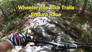
2023 Wheelerville Enduro Stage 1 Climb - Race - Deer Thirty
Photos of Fulton County Mountain Bike
Videos of Fulton County Mountain Bike
trail: Exit
2:58 |
13530 |
Apr 15, 2013
9:36 |
23 |
May 1, 2026
trail: Wheelerville Traverse
16:31 |
69 |
Feb 27, 2026 , Caroga
trail: Eagle Eye
2:52 |
55 |
Sep 16, 2025 , Caroga
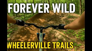
trail: Forever Wild
3:26 |
56 |
Sep 10, 2025 , Caroga
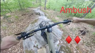
trail: Ambush
0:29 |
485 |
Jul 12, 2023 , Caroga
trail: Eagle Eye
0:59 |
394 |
Jul 26, 2022 , Caroga

trail: Live Free and Fly
2:11 |
723 |
Jul 26, 2022 , Caroga
Recent Trail Reports
Activity Feed
| username | action | type | title | date |
|---|---|---|---|---|
| jhnbcn17 | vote | route | activity #97211947 | Jun 17, 2026 @ 3:14pm 3 hours |
| masoncampbell | add | report | activity #97206059 | Jun 17, 2026 @ 1:18pm 5 hours |
| johnc13 | wishlist | trail | activity #97133110 | Jun 16, 2026 @ 12:58pm 1 day |
| Rogersgs | wishlist | trail | activity #97020063 | Jun 14, 2026 @ 7:51pm 3 days |
| johnc13 | wishlist | trail | activity #96840304 and 1 more | Jun 12, 2026 @ 6:03pm Jun 12, 2026 |
Recent Comments
| username | type | title | comment | date |
|---|---|---|---|---|
| trail | Great trail, in great shape. Short punchy... | Jul 29, 2025 @ 6:52am Jul 29, 2025 | ||
| trail | This is an awesome trail! It might be "blue"... | Jul 24, 2025 @ 4:22pm Jul 24, 2025 | ||
| trail | This quick rip is something you’d normally... | Jul 30, 2022 @ 3:55pm Jul 30, 2022 | ||
| trail | Super fun loop. Lots of ups and downs, well... | Aug 26, 2021 @ 10:38am Aug 26, 2021 | ||
| trail | Very easy, but super cool with all the dead... | Aug 26, 2021 @ 10:37am Aug 26, 2021 |
Local Badges
-

Descent 10k Badge5 awarded -

Epic Mountain Bike Climb 2k1 awarded -

Climbing 10k Badge5 awarded -

Mountain Biking 100k Badge0 awarded -

Epic Ride Descent 2k1 awarded -

Big Ride 30k61 awarded
Bike & Skill Parks
| name | type | city | rating |
|---|---|---|---|
| Royal Mountain Motocross | skill park |
Activity Type Stats
| activitytype | trails | distance | descent | descent distance | total vertical | rating | global rank | state rank | photos | reports | routes | ridelogs |
|---|---|---|---|---|---|---|---|---|---|---|---|---|
| Mountain Bike | 52 | 27 miles | 4,488 ft | 11 miles | 1,086 ft | 161 | 402 | 10 | 6,416 | |||
| E-Bike | 19 | 7 miles | 2,034 ft | 4 miles | 1,033 ft | 349 | 7 | 267 | ||||
| Horse | 1 | 9 miles | 1,198 ft | 4 miles | 784 ft | 10 | ||||||
| Hike | 38 | 33 miles | 4,167 ft | 12 miles | 1,407 ft | 369 | 355 | |||||
| Trail Running | 38 | 33 miles | 4,167 ft | 12 miles | 1,407 ft | 369 | 1 | 147 | ||||
| Snowshoe | 15 | 4 miles | 735 ft | 2 miles | 1,083 ft | 28 | 1 | 147 | ||||
| Downhill Ski | 17 | 3 miles | 2,274 ft | 3 miles | 436 ft | 36 | ||||||
| Nordic Ski | 7 | 4,688 ft | 397 ft | 3,451 ft | 390 ft | 25 | 75 |
Frequently Asked Questions About Fulton County
▼
What are the best places to ride in Fulton County?
Fulton County has 5 areas to explore for mountain biking. The top rated areas are:
▼
What are the highest rated mountain biking trails in Fulton County?
The highest rated mountain biking trails in Fulton County are:
- Forever Wild (4.5/5)
- Perimeter Loop (4.3/5)
- Double Barrel (4.2/5)
- Elm Road (4.2/5)
- Wheelerville Traverse (4.2/5)
▼
What is the best time of the year to ride in Fulton County?
Based on ride log data, the most popular months to ride in Fulton County are:
- August (86 activities)
- September (69 activities)
- July (57 activities)
▼
What is the longest trail in Fulton County?
The longest trail in Fulton County is Perimeter Loop at 4.6 miles. View all trails sorted by distance.
Activities
Trails
- By markholloway
 Trailforks Map Team & contributors
 - Admins: AFTA
- #22754 - 3,969 views
- fulton county activity log | embed map of Fulton County mountain bike trails | fulton county mountain biking points of interest
Downloading of trail gps tracks in kml & gpx formats is enabled for Fulton County.
You must login to download files.