close
-
Layers w
- Weather Layers
- Pro
- Pro
- Pro
- Pro
- Pro
- Pro
- More Layers
- Pro
- Pro
- Pro
- Pro
-
Upgrade to

3D
Trail Conditions
- Unknown
- Snow Groomed
- Snow Packed
- Snow Covered
- Snow Cover Partial
- Freeze/thaw Cycle
- Icy
- Prevalent Mud
- Wet
- Variable
- Ideal
- Dry
- Very Dry
Trail Flow (Ridden Direction)
Trailforks scans users ridelogs to determine the most popular direction each trail is ridden. A good flowing trail network will have most trails flowing in a single direction according to their intension.
The colour categories are based on what percentage of riders are riding a trail in its intended direction.
The colour categories are based on what percentage of riders are riding a trail in its intended direction.
- > 96%
- > 90%
- > 80%
- > 70%
- > 50%
- < 50%
- bi-directional trail
- no data
Trail Last Ridden
Trailforks scans ridelogs to determine the last time a trail was ridden.
- < 2 days
- < 1 week
- < 2 weeks
- < 1 month
- < 6 months
- > 6 months
Trail Ridden Direction
The intended direction a trail should be ridden.
- Downhill Only
- Downhill Primary
- Both Directions
- Uphill Primary
- Uphill Only
- One Direction
Contribute Details
Colors indicate trail is missing specified detail.
- Description
- Photos
- Description & Photos
- Videos
Trail Popularity ?
Trailforks scans ridelogs to determine which trails are ridden the most in the last 9 months.
Trails are compared with nearby trails in the same city region with a possible 25 colour shades.
Think of this as a heatmap, more rides = more kinetic energy = warmer colors.
- most popular
- popular
- less popular
- not popular
ATV/ORV/OHV Filter
Max Vehicle Width
inches
US Cell Coverage
Legend

Radar Time
Activity Recordings
Trailforks uses anonymized public activity data.
?
Activity Recordings
Trailforks uses anonymized public activity data.
?
Personal Heatmap
▶
Activity Types
all
/
none
▶
Options
2
Date range
month
–
Winter Trails
Warning
A routing network for winter maps does not exist. Selecting trails using the winter trails layer has been disabled.
Missing Trails
Most Popular
Least Popular
Trails are colored based on popularity. The more popular a trail is, the more red. Less popular trails trend towards green.
Jump Magnitude Heatmap
Heatmap of where riders jump on trails. Zoom in to see individual jumps, click circles to view jump details.
BC Backroad Status
![map legend]()
Service Road Atlas is a free to use, community-driven service for viewing and creating reports on the numerous back-country service roads around B.C. and Alberta.

Slope Aspect
Direction the slope faces
Trails Deemphasized
Trails are shown in grey.
Only show trails with no bike usage.
Suggested Layers
Based on selected activity type
Save the current map location and zoom level as your default home location whenever this page is loaded.
Save
No description for Gainesville has been added yet!
Login or register to submit one.
Activities Click to view
- Mountain Bike
43 trails
- E-Bike
10 trails
- Gravel Bike
4 trails
- Adaptive Bike
0 trails
- Winter Fat Bike
0 trails
- Horse
7 trails
- Hike
52 trails
- Trail Running
52 trails
Region Details
- 11
- 13
- 12
- 1
Region Status
Open as of Apr 12, 2026Stats
- Avg Trail Rating
- Trails (view details)
- 46
- Trails Mountain Bike
- 43
- Trails E-Bike
- 10
- Trails Gravel Bike
- 4
- Trails Horse
- 7
- Trails Hike
- 52
- Trails Trail Running
- 52
- Total Distance
- 70 miles
- Total Descent
- 1,928 ft
- Total Vertical
- 163 ft
- Highest Trailhead
- 215 ft
- Reports
- 85
- Photos
- 34
- Ridden Counter
- 8,374
Sub Regions
-
Loblolly Woods
- 2
- 1
-
Newnans Lake State Forest
- 3
- 2
-
Sweetwater Preserve
- 1
- 2
-
The Rock Trails
- 1
- 1
- 1
Popular Gainesville Mountain Biking Trails
• 60 ★ 5.0 • 3,533 ft • 43 ft • 105 •
Moderately popular blue difficulty singletrack. This multi-use trail can be used both directions. On average it takes 6 minutes to complete this trail.
• 80 ★ 5.0 • 2,631 ft • 0 ft • 89 •
Popular blue difficulty singletrack. This multi-use trail can be used both directions and has a easy overall physical rating with a 0 ft green climb. Trail visibility is always easy to follow. On average it takes 3 minutes to complete this trail.
• 70 ★ 0.0 • 5 miles • 43 ft • 62 •
This is a 5.5 mile loop on the bank of Newnans Lake. It starts and ends at the of Newnans State Forest where there is parking but no other facilities. Most experienced riders won't find this trail challenging but there is enough here to...
• 45 ★ 0.0 • 2 miles • 27 ft • 60 •
Easy trail popular with hikers (walkers). Sandy in spots with some root exposure, but mostly flat and a nice way to just get a little dirt in close to the city
• 60 ★ 0.0 • 1 mile • 0 ft • 57 •
Nice gravel path with some little wooded side trail options. Some of them are a little hidden and in the wet season can get very flooded
• 95 ★ 0.0 • 2,740 ft • 11 ft • 55 •
Popular green difficulty singletrack. This multi-use trail can be used both directions and has a easy overall physical rating with a 11 ft green climb. On average it takes 4 minutes to complete this trail.
• 90 ★ 0.0 • 801 ft • 0 ft • 47 •
Popular blue difficulty singletrack. This mountain bike primary trail can be used downhill only and has a moderate overall physical rating with a 0 ft blue climb. Trail visibility is always easy to follow. On average it takes minutes to complete this trail.
• 95 ★ 0.0 • 1,312 ft • 16 ft • 46 •
Popular green difficulty singletrack. This mountain bike primary trail can be used both directions. Trail visibility is always easy to follow. On average it takes 1 minutes to complete this trail.
Photos of Gainesville Mountain Bike
Videos of Gainesville Mountain Bike

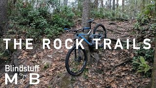
trail: The Rock Trail
11:51 |
536 |
May 2, 2019 , Gainesville
youtuber
![Mountain Biking The Rock Trails of Gainesville, FL]()
842 |
Mar 16, 2017
Recent Trail Reports
| status | trail | date | condition | info | user |
|---|---|---|---|---|---|
| Access Trail | Feb 25, 2026 @ 3:46pm (America/New_York) Feb 25, 2026 | Very Dry | Orangecycle1 | ||
| Lake Pithlachocco Trail | Feb 25, 2026 @ 3:46pm (America/New_York) Feb 25, 2026 | Very Dry | Orangecycle1 | ||
| Hiking Trail 01 | Feb 22, 2026 @ 9:38am (America/Nassau) Feb 22, 2026 | Ideal | Orangecycle1 | ||
| Alachua Lake Overlook | Apr 12, 2025 @ 8:30am Apr 12, 2025 | Ideal | GettinGritty | ||
| Sweetwater Overlook | Feb 8, 2025 @ 10:43am Feb 8, 2025 | Ideal | brucerioux WACH NEMBA | ||
| Loblolly Woods Trail | Aug 25, 2024 @ 8:27am Aug 25, 2024 | Variable | 1dot0 | ||
| Hogtown Creek Greenway | Aug 25, 2024 @ 8:27am Aug 25, 2024 | Ideal | 1dot0 | ||
| 8th Ave West | Mar 31, 2023 @ 7:03pm Mar 31, 2023 | Ideal | icthus13 SanFelasco | ||
| Loblolly Woods Loop | Mar 31, 2023 @ 7:03pm Mar 31, 2023 | Ideal | icthus13 SanFelasco | ||
| Cabana Beach Backwoods | Mar 31, 2023 @ 7:03pm Mar 31, 2023 | Dry | icthus13 SanFelasco |
Activity Feed
| username | action | type | title | date |
|---|---|---|---|---|
| grkuntzmd | wishlist | trail | activity #96490068 | Jun 7, 2026 @ 12:52pm Jun 7, 2026 |
| icthus13 | like | directory | activity #95178442 | May 21, 2026 @ 8:49am May 21, 2026 |
| icthus13 | comment | directory | activity #95178426 | May 21, 2026 @ 8:49am May 21, 2026 |
| icthus13 | comment | directory | activity #95178407 and 1 more | May 21, 2026 @ 8:48am May 21, 2026 |
| 4davjul | wishlist | trail | activity #95012012 | May 18, 2026 @ 5:35pm May 18, 2026 |
Recent Comments
| username | type | title | comment | date |
|---|---|---|---|---|
| report | The water has receded at this point. | Nov 24, 2025 @ 1:54pm Nov 24, 2025 | ||
| trail | Trail Name: Homeless Hills | Sep 16, 2025 @ 12:08pm Sep 16, 2025 | ||
| trail | Homeless camp right at the start. So…. Maybe... | Jan 12, 2025 @ 2:14pm Jan 12, 2025 | ||
| trail | This trail is closed due to it being private... | Oct 19, 2024 @ 4:24pm Oct 19, 2024 | ||
| trail | The trail is fairly physically challenging due... | Oct 3, 2024 @ 10:40am Oct 3, 2024 |
Local Badges
-

10 Blue Trails157 awarded -

Epic Ride Climb 2k0 awarded -

Climbing 10k Badge33 awarded -

Climbing 100k Badge0 awarded -

Epic Ride Descent 2k0 awarded -

Descent 10k Badge33 awarded
Activity Type Stats
| activitytype | trails | distance | descent | descent distance | total vertical | rating | global rank | state rank | photos | reports | routes | ridelogs |
|---|---|---|---|---|---|---|---|---|---|---|---|---|
| Mountain Bike | 43 | 56 miles | 1,778 ft | 15 miles | 164 ft | #3,241 | #1,114 | 34 | 85 | 11,400 | ||
| E-Bike | 10 | 17 miles | 187 ft | 6 miles | 85 ft | #5,977 | #1,823 | 69 | 323 | |||
| Gravel Bike | 4 | #615 | #1,141 | 1 | 33 | |||||||
| Horse | 7 | 28 miles | 276 ft | 8 miles | 92 ft | #1,799 | #1,015 | 23 | ||||
| Hike | 52 | 70 miles | 1,929 ft | 18 miles | 164 ft | #3,802 | #1,346 | 85 | 420 | |||
| Trail Running | 52 | 70 miles | 1,929 ft | 18 miles | 164 ft | #3,592 | #1,074 | 85 | 164 |
Frequently Asked Questions About Gainesville
▼
What are the best places to ride in Gainesville?
Gainesville has 5 areas to explore for mountain biking. The top rated areas are:
▼
What are the highest rated mountain biking trails in Gainesville?
The highest rated mountain biking trails in Gainesville are:
- Sinkhole Pond (East Trail) (4.1/5)
- Sinkhole Pond - North Loop (4.1/5)
- 8th Ave West (0/5)
- Loblolly Woods Loop (0/5)
- Frat Row Downhill (0/5)
▼
What is the best time of the year to ride in Gainesville?
Based on ride log data, the most popular months to ride in Gainesville are:
- October (60 activities)
- March (60 activities)
- February (59 activities)
▼
Where can I park to ride in Gainesville?
There are 8 parking locations listed in Gainesville. The most popular parking spots are: View all parking and trailhead locations on the map to plan your visit.
Activities
Trails
- By brenthillier
 NSMBA TRAILFORKS & contributors
 - Admins: apply
- #3675 - 12,322 views
- gainesville activity log | embed map of Gainesville mountain bike trails | gainesville mountain biking points of interest
Downloading of trail gps tracks in kml & gpx formats is enabled for Gainesville.
You must login to download files.