close
-
Layers w
- Weather Layers
- Pro
- Pro
- Pro
- Pro
- Pro
- Pro
- More Layers
- Pro
- Pro
- Pro
- Pro
-
Upgrade to

3D
Trail Conditions
- Unknown
- Snow Groomed
- Snow Packed
- Snow Covered
- Snow Cover Partial
- Freeze/thaw Cycle
- Icy
- Prevalent Mud
- Wet
- Variable
- Ideal
- Dry
- Very Dry
Trail Flow (Ridden Direction)
Trailforks scans users ridelogs to determine the most popular direction each trail is ridden. A good flowing trail network will have most trails flowing in a single direction according to their intension.
The colour categories are based on what percentage of riders are riding a trail in its intended direction.
The colour categories are based on what percentage of riders are riding a trail in its intended direction.
- > 96%
- > 90%
- > 80%
- > 70%
- > 50%
- < 50%
- bi-directional trail
- no data
Trail Last Ridden
Trailforks scans ridelogs to determine the last time a trail was ridden.
- < 2 days
- < 1 week
- < 2 weeks
- < 1 month
- < 6 months
- > 6 months
Trail Ridden Direction
The intended direction a trail should be ridden.
- Downhill Only
- Downhill Primary
- Both Directions
- Uphill Primary
- Uphill Only
- One Direction
Contribute Details
Colors indicate trail is missing specified detail.
- Description
- Photos
- Description & Photos
- Videos
Trail Popularity ?
Trailforks scans ridelogs to determine which trails are ridden the most in the last 9 months.
Trails are compared with nearby trails in the same city region with a possible 25 colour shades.
Think of this as a heatmap, more rides = more kinetic energy = warmer colors.
- most popular
- popular
- less popular
- not popular
ATV/ORV/OHV Filter
Max Vehicle Width
inches
US Cell Coverage
Legend

Radar Time
Activity Recordings
Trailforks uses anonymized public activity data.
?
Activity Recordings
Trailforks uses anonymized public activity data.
?
Personal Heatmap
▶
Activity Types
all
/
none
▶
Options
2
Date range
month
–
Winter Trails
Warning
A routing network for winter maps does not exist. Selecting trails using the winter trails layer has been disabled.
Missing Trails
Most Popular
Least Popular
Trails are colored based on popularity. The more popular a trail is, the more red. Less popular trails trend towards green.
Jump Magnitude Heatmap
Heatmap of where riders jump on trails. Zoom in to see individual jumps, click circles to view jump details.
BC Backroad Status
![map legend]()
Service Road Atlas is a free to use, community-driven service for viewing and creating reports on the numerous back-country service roads around B.C. and Alberta.

Slope Aspect
Direction the slope faces
Trails Deemphasized
Trails are shown in grey.
Only show trails with no bike usage.
Suggested Layers
Based on selected activity type
Save the current map location and zoom level as your default home location whenever this page is loaded.
Save
No description for Gaiola has been added yet!
Login or register to submit one.
This region uses the Uk/Euro style trail grading system.
Activities Click to view
- Mountain Bike
32 trails
- E-Bike
19 trails
- Gravel Bike
0 trails
- Adaptive Bike
- Hike
27 trails
- Trail Running
27 trails
Region Details
- 11
- 8
- 10
Region Status
Open as of Jun 7, 2026Stats
- Avg Trail Rating
- Trails (view details)
- 29
- Trails Mountain Bike
- 32
- Trails E-Bike
- 19
- Trails Hike
- 27
- Trails Trail Running
- 27
- Total Distance
- 46 miles
- Total Descent Distance
- 26 miles
- Total Descent
- 13,365 ft
- Total Vertical
- 3,649 ft
- Highest Trailhead
- 5,771 ft
- Reports
- 181
- Photos
- 59
- Ridden Counter
- 1,647
Sub Regions
-
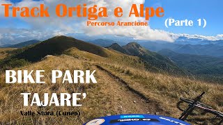
Bike Park Tajarè
- 8
- 9
Popular Gaiola Mountain Biking Trails
• 100 ★ 5.0 • 4,094 ft • 10 ft • 129 •
Starting point at "Pertus del Colletto" We start immediately with a couple of leaning curves that make the adrenaline rush high! Continue on a super flow surface in the wild woods with straight lines and bends in support. We then...
• 100 ★ 4.4 • 3 miles • 107 ft • 115 •
Reached the crossroads of Scanavasse hamlet, continue following a fast and relaxing dirt track.
• 90 ★ 5.0 • 1 mile • 42 ft • 65 •
The trail was born thanks to the fundamental economic contribution first of all from the Municipality of Moiola, the Proposta80 social cooperative and, last but not least, your micro-donations for the latest crowdfunding It is located...
• 60 ★ 4.6 • 3 miles • 0 ft • 60 •
A fantastic ridge is waiting for us, but be careful not to be distracted by the landscape around you, the track to Alpe di Rittana is always challenging! Going down by the Alpe di Rittana with an extreme beautiful trail, you reach the...
• 80 ★ 3.7 • 3 miles • 57 ft • 55 •
A very long single-track that runs through the ridge over Gaiola and Rittana, is the beautiful final for this intense track.
• 75 ★ 5.0 • 1 mile • 0 ft • 51 •
After mountain hut of Paraloup, a short but intense ascent to get the long single-track in descent, which takes us back to the Valloriate territory and village of Chiotti.
• 70 ★ 0.0 • 827 ft • 0 ft • 48 •
We have found the Dahu's lair! This is the variant that allows you to see it, and to bypass the Cappella dell'Incoronata and the giant bench
• 40 ★ 3.7 • 2 miles • 0 ft • 46 •
Arrived at the hut under the mountain of the same name, in front of you there’s a long and satisfying single-track, made of ups and downs and some technical steps, which leads you to the village Chiotti.
Gaiola Mountain Bike Routes
8 miles • 1,053 ft • 0 • Point to Point •
si arriva comodamente, in macchina fino al parcheggio a gaiola,via g.marconi 10 12010 gaiola CN . la...
8 miles • 1,068 ft • 0 •
SENTIERO DEI CASTELLI – PURPLE TRACK -Difficulty: Easy climb, Easy / medium descent, low exposure (e1)...
12 miles • 2,280 ft • 0 •
--------------------------------------------------------------
6 miles • 1,998 ft • 0 • Point to Point •
-----------------------------------------------------------------
Photos of Gaiola Mountain Bike
Videos of Gaiola Mountain Bike

trail: YETI Enduro BPT
4:06 |
21 |
Dec 15, 2021
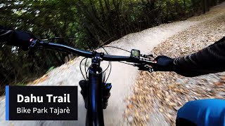
trail: Dahu Enduro BPT
6:22 |
178 |
Oct 15, 2023 , gaiola

trail: YETI Enduro BPT
5:10 |
257 |
Mar 25, 2022 , gaiola
11:10 |
35 |
Sep 5, 2025 , gaiola

trail: DH Funse BPT
6:06 |
48 |
Sep 5, 2025 , gaiola
Recent Trail Reports
| status | trail | date | condition | info | user |
|---|---|---|---|---|---|
| YETI Enduro BPT | May 23, 2026 @ 9:52am (Europe/Rome) May 23, 2026 | Ideal | danilo959 | ||
| Scanavasse - Rocca BPT Arancione | May 23, 2026 @ 9:52am (Europe/Rome) May 23, 2026 | Ideal | danilo959 | ||
| Chiot Rosa- Funse BPT | May 23, 2026 @ 9:52am (Europe/Rome) May 23, 2026 | Ideal | danilo959 | ||
| Alpe - Chiot Rosa BPT Arancione | May 23, 2026 @ 9:52am (Europe/Rome) May 23, 2026 | Ideal | danilo959 | ||
| Gaiola-Malga del Tajarè BPT | May 9, 2026 @ 7:54am (Europe/Monaco) May 8, 2026 | Ideal | mandu73 | ||
| Forcella nella Roccia Lower | May 4, 2026 @ 9:10am (Europe/Rome) May 4, 2026 | Ideal | MassimoQn2w9z | ||
| Dahu Enduro BPT | Apr 22, 2026 @ 11:01pm (Europe/Rome) Apr 22, 2026 | Variable | bikeparktajare | ||
| DH Funse BPT | Mar 30, 2026 @ 8:39pm (Europe/Rome) Mar 30, 2026 | Ideal | mandu73 | ||
| Traverso Tetti Battaglie | Oct 1, 2025 @ 1:17pm (Europe/Rome) Oct 1, 2025 | Wet | bikeparktajare | ||
| Rochasun Trail BPT | Sep 28, 2025 @ 10:09am (Europe/Monaco) Sep 28, 2025 | Ideal | elbati |
Activity Feed
| username | action | type | title | date |
|---|---|---|---|---|
| Nidiki-Robi | ridden | trail | activity #96799884 | Jun 12, 2026 @ 6:41am Jun 12, 2026 |
| danilo959 | add | report | activity #95437982 and 3 more | May 24, 2026 @ 12:51pm May 24, 2026 |
| tobihipp82 | wishlist | trail | activity #95236332 | May 22, 2026 @ 6:02am May 22, 2026 |
| mandu73 | add | report | activity #94323313 | May 9, 2026 @ 3:55am May 9, 2026 |
| MassimoQn2w9z | add | report | activity #94009431 | May 4, 2026 @ 12:11am May 4, 2026 |
Recent Comments
| username | type | title | comment | date |
|---|---|---|---|---|
| report | Ci stiamo lavorando. Troppo buoni ;) | Oct 2, 2024 @ 1:23pm Oct 2, 2024 | ||
| trail | Thanks! | Feb 27, 2024 @ 1:14pm Feb 27, 2024 | ||
| trail | Da bike park! Molto bello. Agganciandolo al... | Dec 31, 2023 @ 6:11am Dec 31, 2023 | ||
| trail | Grazie Birba! | Sep 18, 2023 @ 2:05pm Sep 18, 2023 | ||
| trail | Ho avuto la fortuna di provarlo il giorno dopo... | Sep 14, 2023 @ 7:33am Sep 14, 2023 |
Local Badges
-

Completionist0 awarded
Activity Type Stats
| activitytype | trails | distance | descent | descent distance | total vertical | rating | global rank | state rank | photos | reports | routes | ridelogs |
|---|---|---|---|---|---|---|---|---|---|---|---|---|
| Mountain Bike | 32 | 46 miles | 13,366 ft | 26 miles | 3,648 ft | #3,445 | #183 | 59 | 181 | 4 | 1,701 | |
| E-Bike | 19 | 32 miles | 8,917 ft | 19 miles | 3,501 ft | #3,996 | #380 | 174 | 1 | 316 | ||
| Hike | 27 | 43 miles | 11,942 ft | 24 miles | 3,648 ft | #5,441 | #246 | 164 | 140 | |||
| Trail Running | 27 | 43 miles | 11,942 ft | 24 miles | 3,648 ft | #4,865 | #223 | 164 | 24 |
Frequently Asked Questions About Gaiola
▼
What are the best places to ride in Gaiola?
Gaiola has 1 areas to explore for mountain biking. The top rated areas are:
▼
What are the highest rated mountain biking trails in Gaiola?
The highest rated mountain biking trails in Gaiola are:
- YETI Enduro BPT (4.3/5)
- Alpe - Chiot Rosa BPT Arancione (4.3/5)
- Dahu Enduro BPT (4.2/5)
- Paraloup - Chiotti BPT Giallo (4.2/5)
- Scanavasse - Rocca BPT Arancione (4.1/5)
▼
What is the best time of the year to ride in Gaiola?
Based on ride log data, the most popular months to ride in Gaiola are:
- July (8 activities)
- September (7 activities)
- June (6 activities)
▼
Where can I park to ride in Gaiola?
There are 8 parking locations listed in Gaiola. The most popular parking spots are: View all parking and trailhead locations on the map to plan your visit.
Activities
Trails
Points of Interest
- By bikeparktajare & contributors
- Admins: silviu86, adessoomaipiu
- #36262 - 856 views
- gaiola activity log | embed map of Gaiola mountain bike trails | gaiola mountain biking points of interest
Downloading of trail gps tracks in kml & gpx formats is enabled for Gaiola.
You must login to download files.