close
-
Layers w
- Weather Layers
- Pro
- Pro
- Pro
- Pro
- Pro
- Pro
- More Layers
- Pro
- Pro
- Pro
- Pro
-
Upgrade to

3D
Trail Conditions
- Unknown
- Snow Groomed
- Snow Packed
- Snow Covered
- Snow Cover Partial
- Freeze/thaw Cycle
- Icy
- Prevalent Mud
- Wet
- Variable
- Ideal
- Dry
- Very Dry
Trail Flow (Ridden Direction)
Trailforks scans users ridelogs to determine the most popular direction each trail is ridden. A good flowing trail network will have most trails flowing in a single direction according to their intension.
The colour categories are based on what percentage of riders are riding a trail in its intended direction.
The colour categories are based on what percentage of riders are riding a trail in its intended direction.
- > 96%
- > 90%
- > 80%
- > 70%
- > 50%
- < 50%
- bi-directional trail
- no data
Trail Last Ridden
Trailforks scans ridelogs to determine the last time a trail was ridden.
- < 2 days
- < 1 week
- < 2 weeks
- < 1 month
- < 6 months
- > 6 months
Trail Ridden Direction
The intended direction a trail should be ridden.
- Downhill Only
- Downhill Primary
- Both Directions
- Uphill Primary
- Uphill Only
- One Direction
Contribute Details
Colors indicate trail is missing specified detail.
- Description
- Photos
- Description & Photos
- Videos
Trail Popularity ?
Trailforks scans ridelogs to determine which trails are ridden the most in the last 9 months.
Trails are compared with nearby trails in the same city region with a possible 25 colour shades.
Think of this as a heatmap, more rides = more kinetic energy = warmer colors.
- most popular
- popular
- less popular
- not popular
ATV/ORV/OHV Filter
Max Vehicle Width
inches
US Cell Coverage
Legend

Radar Time
Activity Recordings
Trailforks uses anonymized public activity data.
?
Activity Recordings
Trailforks uses anonymized public activity data.
?
Personal Heatmap
▶
Activity Types
all
/
none
▶
Options
2
Date range
month
–
Winter Trails
Warning
A routing network for winter maps does not exist. Selecting trails using the winter trails layer has been disabled.
Missing Trails
Most Popular
Least Popular
Trails are colored based on popularity. The more popular a trail is, the more red. Less popular trails trend towards green.
Jump Magnitude Heatmap
Heatmap of where riders jump on trails. Zoom in to see individual jumps, click circles to view jump details.
BC Backroad Status
![map legend]()
Service Road Atlas is a free to use, community-driven service for viewing and creating reports on the numerous back-country service roads around B.C. and Alberta.

Slope Aspect
Direction the slope faces
Trails Deemphasized
Trails are shown in grey.
Only show trails with no bike usage.
Suggested Layers
Based on selected activity type
Save the current map location and zoom level as your default home location whenever this page is loaded.
Save
No description for Galbiate has been added yet!
Login or register to submit one.
This region uses the Uk/Euro style trail grading system.
Activities Click to view
- Mountain Bike
16 trails
- E-Bike
14 trails
- Adaptive Bike
0 trails
- Winter Fat Bike
0 trails
- Hike
24 trails
- Trail Running
24 trails
Region Details
- 2
- 2
- 2
- 8
- 1
Region Status
Open as of Jun 13, 2026Stats
- Avg Trail Rating
- Trails (view details)
- 24
- Trails Mountain Bike
- 16
- Trails E-Bike
- 14
- Trails Horse
- 3
- Trails Hike
- 24
- Trails Trail Running
- 24
- Total Distance
- 23 miles
- Total Descent
- 6,995 ft
- Total Vertical
- 2,249 ft
- Highest Trailhead
- 2,897 ft
- Reports
- 175
- Photos
- 35
- Ridden Counter
- 1,601
Sub Regions
-
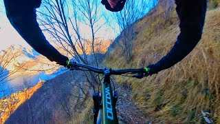
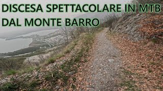
Monte Barro
- 2
- 2
- 5
- 1
- 1
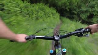
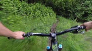
Popular Galbiate Mountain Biking Trails
• 90 ★ 0.0 • 1,467 ft • 126 ft • 123 •
Breve sentiero sopra l'Eremo del Monte Barro
• 90 ★ 5.0 • 4 miles • 56 ft • 109 •
Popular white difficulty paved path. This multi-use trail can be used both directions. On average it takes 20 minutes to complete this trail.
• 85 ★ 4.0 • 3 miles • 49 ft • 87 •
Few meters from the water of the lake. Lecco Pescarenico to Vercurago.
• 30 ★ 3.5 • 1 mile • 86 ft • 23 •
GAGGIO FLOW - Uno dei tanti trail sulle pendici del monte barro. Sopra Malgrate, contiene ogni tipo di terreno, dalle rocce scoperte alla terra morbida.
• 60 ★ 3.5 • 4,109 ft • 119 ft • 21 •
Prima single track nel bosco, poi mulattiera ripida
• 25 ★ 3.0 • 1 mile • 151 ft • 19 • • hike
Very scenic but very technical and exposed singletrack
Galbiate Mountain Bike Routes
Photos of Galbiate Mountain Bike
Videos of Galbiate Mountain Bike
trail: La Culcinera
24:38 |
34 |
Jan 29, 2026 , Galbiate
trail: Pian sciresa trail
10:55 |
55 |
May 17, 2025 , Galbiate
trail: Discesa di San Michele
10:55 |
104 |
May 17, 2025 , Galbiate
trail: Strada della cava
17:40 |
409 |
Sep 29, 2024 , Galbiate
trail: PESCALINA
2:51 |
156 |
Mar 21, 2024 , Galbiate
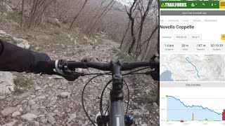
trail: Novella Coppelle
8:09 |
99 |
Mar 19, 2023 , Galbiate
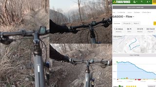
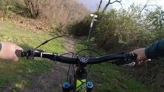
trail: Gaggio Flow
13:09 |
195 |
Mar 6, 2023 , Galbiate
Recent Trail Reports
Activity Feed
| username | action | type | title | date |
|---|---|---|---|---|
| poporni | add | report | activity #97029026 and 2 more | Jun 15, 2026 @ 2:22am Jun 15, 2026 |
| Stefanof2Io9R | ridden | trail | activity #94518058 and 2 more | May 11, 2026 @ 2:41pm May 11, 2026 |
| Stefanof2Io9R | ridden | trail | activity #94198811 | May 6, 2026 @ 10:04pm May 6, 2026 |
| Guret | add | report | activity #93891403 | May 2, 2026 @ 1:41pm May 2, 2026 |
| samueeell | vote | trail | activity #93470085 | Apr 26, 2026 @ 12:47pm Apr 26, 2026 |
Recent Comments
| username | type | title | comment | date |
|---|---|---|---|---|
| trail | Cambia classificazione in Nero! Tutta roccia | Nov 13, 2025 @ 12:42am Nov 13, 2025 | ||
| report | Sentiero a tratti scavato | Mar 16, 2025 @ 5:44am Mar 16, 2025 | ||
| trail | Vaga curiosità (da amante del genere) è... | Oct 4, 2024 @ 2:41pm Oct 4, 2024 | ||
| trail | Sentiero rivoluzionato dal taglio boschivo | Oct 10, 2023 @ 1:53am Oct 10, 2023 | ||
| trail | confermo ahahah, poco interessante | Oct 10, 2023 @ 12:37am Oct 10, 2023 |
Local Badges
-

Completionist0 awarded -

10 Blue Trails21 awarded -

Epic Mountain Bike Climb 2k46 awarded -

Climbing 10k Badge23 awarded -

Mountain Biking 100k Badge0 awarded -

Epic Ride Descent 2k46 awarded
Activity Type Stats
| activitytype | trails | distance | descent | descent distance | total vertical | rating | global rank | state rank | photos | reports | routes | ridelogs |
|---|---|---|---|---|---|---|---|---|---|---|---|---|
| Mountain Bike | 16 | 18 miles | 5,190 ft | 9 miles | 1,821 ft | #6,040 | #475 | 33 | 174 | 1 | 1,354 | |
| E-Bike | 14 | 18 miles | 4,738 ft | 9 miles | 1,821 ft | #5,288 | #513 | 166 | 1 | 253 | ||
| Horse | 3 | 2 miles | 1,453 ft | 2 miles | 1,535 ft | 9 | ||||||
| Hike | 24 | 23 miles | 6,995 ft | 11 miles | 2,251 ft | #6,307 | #318 | 175 | 262 | |||
| Trail Running | 24 | 23 miles | 6,995 ft | 11 miles | 2,251 ft | #6,501 | #366 | 2 | 175 | 238 |
Frequently Asked Questions About Galbiate
▼
What are the best places to ride in Galbiate?
Galbiate has 1 areas to explore for mountain biking. The top rated areas are:
▼
What are the highest rated mountain biking trails in Galbiate?
The highest rated mountain biking trails in Galbiate are:
- Ciclabile Olginate - Malgrate (4.2/5)
- Sentiero di Mezzo (4/5)
- Ciclabile Pescarenico - Vercurago (4/5)
- PESCALINA (4/5)
- La Valmolina (4/5)
▼
What is the best time of the year to ride in Galbiate?
Based on ride log data, the most popular months to ride in Galbiate are:
- October (9 activities)
- May (5 activities)
- January (5 activities)
▼
Where can I park to ride in Galbiate?
There are 3 parking locations listed in Galbiate. The most popular parking spots are: View all parking and trailhead locations on the map to plan your visit.
Activities
Trails
- By MatteoDeiCas
 & contributors
 - Admins: marcoangeletti, adessoomaipiu, micheletraversi, NORTHNLINE
- #25630 - 1,795 views
- galbiate activity log | embed map of Galbiate mountain bike trails | galbiate mountain biking points of interest
Downloading of trail gps tracks in kml & gpx formats is enabled for Galbiate.
You must login to download files.