close
-
Layers w
- Weather Layers
- Pro
- Pro
- Pro
- Pro
- Pro
- Pro
- More Layers
- Pro
- Pro
- Pro
- Pro
-
Upgrade to

3D
Trail Conditions
- Unknown
- Snow Groomed
- Snow Packed
- Snow Covered
- Snow Cover Partial
- Freeze/thaw Cycle
- Icy
- Prevalent Mud
- Wet
- Variable
- Ideal
- Dry
- Very Dry
Trail Flow (Ridden Direction)
Trailforks scans users ridelogs to determine the most popular direction each trail is ridden. A good flowing trail network will have most trails flowing in a single direction according to their intension.
The colour categories are based on what percentage of riders are riding a trail in its intended direction.
The colour categories are based on what percentage of riders are riding a trail in its intended direction.
- > 96%
- > 90%
- > 80%
- > 70%
- > 50%
- < 50%
- bi-directional trail
- no data
Trail Last Ridden
Trailforks scans ridelogs to determine the last time a trail was ridden.
- < 2 days
- < 1 week
- < 2 weeks
- < 1 month
- < 6 months
- > 6 months
Trail Ridden Direction
The intended direction a trail should be ridden.
- Downhill Only
- Downhill Primary
- Both Directions
- Uphill Primary
- Uphill Only
- One Direction
Contribute Details
Colors indicate trail is missing specified detail.
- Description
- Photos
- Description & Photos
- Videos
Trail Popularity ?
Trailforks scans ridelogs to determine which trails are ridden the most in the last 9 months.
Trails are compared with nearby trails in the same city region with a possible 25 colour shades.
Think of this as a heatmap, more rides = more kinetic energy = warmer colors.
- most popular
- popular
- less popular
- not popular
ATV/ORV/OHV Filter
Max Vehicle Width
inches
US Cell Coverage
Legend

Radar Time
Activity Recordings
Trailforks uses anonymized public activity data.
?
Activity Recordings
Trailforks uses anonymized public activity data.
?
Personal Heatmap
▶
Activity Types
all
/
none
▶
Options
2
Date range
month
–
Winter Trails
Warning
A routing network for winter maps does not exist. Selecting trails using the winter trails layer has been disabled.
Missing Trails
Most Popular
Least Popular
Trails are colored based on popularity. The more popular a trail is, the more red. Less popular trails trend towards green.
Jump Magnitude Heatmap
Heatmap of where riders jump on trails. Zoom in to see individual jumps, click circles to view jump details.
BC Backroad Status
![map legend]()
Service Road Atlas is a free to use, community-driven service for viewing and creating reports on the numerous back-country service roads around B.C. and Alberta.

Slope Aspect
Direction the slope faces
Trails Deemphasized
Trails are shown in grey.
Only show trails with no bike usage.
Suggested Layers
Based on selected activity type
Save the current map location and zoom level as your default home location whenever this page is loaded.
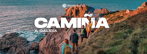
SaveGalicia es una comunidad autónoma española, situada al noroeste de la península ibérica y formada por las provincias de La Coruña, Lugo, Orense y Pontevedra, las cuales se dividen en 314 municipios que se agrupan en 53 comarcas. Geográficamente, limita al norte con el mar Cantábrico, al sur con Portugal, al oeste con el océano Atlántico y al este con el Principado de Asturias y con la comunidad de Castilla y León (provincias de Zamora y de León).
This region uses the Uk/Euro style trail grading system.
Region Details
- 1,993
- 52
- 249
- 1,040
- 329
- 51
- 1
Stats
- Avg Trail Rating
- Trails (view details)
- 3,735
- Trails Mountain Bike
- 3,718
- Trails E-Bike
- 3,604
- Trails Gravel Bike
- 33
- Trails Adaptive Bike
- 158
- Trails Winter Fat Bike
- 11
- Trails Horse
- 95
- Trails Hike
- 3,463
- Trails Trail Running
- 3,465
- Trails Dirtbike/Moto
- 39
- Trails ATV/ORV/OHV
- 2
- Trails Downhill Ski
- 6
- Total Distance
- 2,682 miles
- Total Descent
- 559,482 ft
- Total Vertical
- 6,880 ft
- Highest Trailhead
- 6,881 ft
- Reports
- 5,384
- Photos
- 887
- Ridden Counter
- 60,071
Articles
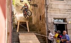
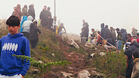
Event Preview: Stair Gaps & Alleyway Hucks Await at MTB Downtown Vigo
Jun 5, 2026 from pinkbike.com
Drop in from the historic O Castro fortress as the Marisquiño festival transforms Spain’s coastal corridors into a 135-vertical-meter urban...
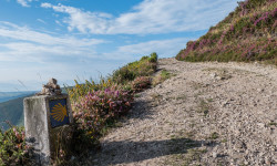
How Long Does it Take to Walk the Camino de Santiago? A Beginner’s Guide to This and More
May 7, 2025 from outsideonline.com
Hikers around the world are rediscovering Spain's Camino de Santiago, Medieval Europe's version of the thru-hike. A veteran of the pilgrimage...
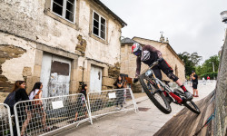
Race Report: A Wooden Roller Coaster Through the Streets for the Villa De Sarria Urban Downhill
Jul 24, 2019 from pinkbike.com
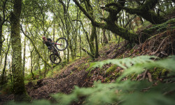
Video: Iago Garay Visits Vigo to Find World Class Trails
Jun 28, 2019 from pinkbike.com
Nacho Trueba and Iago Garay head to Vigo to film a short video in some of the cool spots around the area.
Popular Trail Networks
view all areas »Sub Regions
- A Coruña (Provincia) (682)
- As Pontes (32)
- Lago As Pontes (12)
- Carballo (44)
- Monte Neme (43)
- Ferrolterra (41)
- Pedroso (9)
- La Coruña (253)
- A Zapateira (29)
- Arteixo (14)
- Costa Da Morte (14)
- Monte Barbeito (9)
- Monte Lendo (7)
- Monte Xalo (40)
- Novo Mesoiro (10)
- Melide (3)
- Montes do Bocelo (3)
- Mugardos (91)
- Noia (80)
- Monte Louro (2)
- Monte San Lois (3)
- San Fins (29)
- Ortegal (36)
- Ribeira (122)
- Santiago De Compostela (55)
- Monte Pedroso (12)
- As Pontes (32)
- Lugo (Provincia) (373)
- Burela (29)
- Monte Castelo (29)
- Foz (1)
- Lugo (207)
- A Ermida (5)
- Lagos De Teixeiro (8)
- Monforte de Lemos (1)
- Ombreiro (54)
- Penarrubia (120)
- Penas de Rodas (1)
- Páramo (45)
- Monte do Páramo (3)
- Monte Santa Cristina (43)
- Ribadeo (55)
- Monte Pousadoiro (15)
- San Cibrao (15)
- Medela (15)
- sarria (60)
- Viveiro (5)
- Xove (18)
- Monte Vello (18)
- Lucus Bikepark (3)
- Burela (29)
- Ourense (Provincia) (1,344)
- Maceda (2)
- Ourense (1,090)
- Amoeiro (1)
- Arnoia (44)
- Carballiño (620)
- Castro de Beiro (19)
- Montealegre (38)
- Pena Trevinca (53)
- Pereiro de Aguiar (60)
- Ribadavia (115)
- San Cibrao Das Viñas (78)
- San Pedro De Rocas (20)
- Serra de Pena Corneira (0)
- Toén (71)
- Parada De Sil (90)
- Pobra De Trives (17)
- Manzaneda Bike Park (17)
- Puga (4)
- A Fenteira (10)
- Verín (7)
- Cabreiroá (5)
- Xinzo De Limia (123)
- Pontevedra (Provincia) (1,338)
- A Guarda (119)
- Monte Santa Trega (44)
- Monte Torroso (36)
- Serra da Groba (37)
- Cambados (50)
- Caldas de Reis (3)
- Illa de Arousa (12)
- Monte Lobeira (13)
- Monte Siradella (12)
- Valga (10)
- Chapela (46)
- Monte Vixiador (45)
- Couso (8)
- Couso Freeride (8)
- Cuntis (1)
- Vilar Bikepark (7)
- Donas (10)
- Moaña (76)
- Paralaia (76)
- Mosteiro (6)
- Monte Castrove (85)
- Monte Do Con (39)
- Verducido (15)
- O Porriño (72)
- Faro de Budiño (71)
- O Rosal (76)
- As Eiras (26)
- Serra do Argalo (50)
- Ponteareas (22)
- Monte Picaraña (22)
- Pontevedra (247)
- A Fracha (65)
- Redondela (27)
- Reboreda (27)
- Tui (65)
- Monte Aloia (65)
- Vigo (340)
- A Risca (50)
- Baiona (30)
- Beade (8)
- Cedeira (45)
- Coruxo (68)
- Gondomar (23)
- Monte Monzón (6)
- Monteferro (23)
- Salceda de Caselas (33)
- Serra do Galleiro (10)
- Valadares (8)
- Vilagarcía (217)
- Monte Xiabre (151)
- Zamáns (35)
- Serra do Galiñeiro (35)
- Covelo (24)
- Lago de Castiñeiras (45)
- A Guarda (119)
Popular Galicia Mountain Biking Trails
• 90 ★ 0.0 • 2 miles • 43 ft • 144 •
Popular blue difficulty wilderness trail. This multi-use trail can be used both directions and has a moderate overall physical rating with a 43 ft blue climb. Trail visibility is sometimes hard to follow. On average it takes 7 minutes to complete this trail.
• 100 ★ 5.0 • 2,448 ft • 0 ft • 137 •
Popular red difficulty singletrack. This multi-use trail can be used downhill only and has a hard overall physical rating. It features berm, drop, jump and rock garden. Trail visibility is always easy to follow. On average it takes 3 minutes to complete this trail.
• 95 ★ 0.0 • 1 mile • 163 ft • 120 •
Popular white difficulty gravel path. This multi-use trail can be used both directions and has a easy overall physical rating with a 163 ft green climb. Trail visibility is always easy to follow. On average it takes 12 minutes to complete this trail.
• 95 ★ 0.0 • 3 miles • 339 ft • 114 •
Popular white difficulty gravel path. This multi-use trail can be used both directions and has a easy overall physical rating with a 339 ft green climb. Trail visibility is always easy to follow. On average it takes 21 minutes to complete this trail.
• 75 ★ 5.0 • 3,484 ft • 0 ft • 112 •
En esta pista mantenemos el nivel de dificultad de Carqueixa con algún que otro salto artificial, pasos por bosque con curvas muy bien dibujadas y terreno ideal. Siempre con alternativas para los que no se sientan preparados para volar...
• 95 ★ 4.0 • 3,665 ft • 0 ft • 110 •
En este circuito incrementamos un poco la dificultad, con algunos saltos artificiales de poca dificultad y siempre con alternativa para los que no quieran despegar sus ruedas del suelo más de lo imprescindible. Nos adentraremos en...
• 70 ★ 4.0 • 3,622 ft • 0 ft • 103 •
Recorrido para todos los públicos, sin obstáculos aéreos y ciclable en su totalidad. Perfecto para iniciarse, pero con mucho flow para los más experimentados. Muchas curvas, de todo tipo, con peraltes y mesetas enlazados, zonas de...
• 100 ★ 5.0 • 4,275 ft • 0 ft • 95 •
Recorrido para todos los públicos, sin obstáculos aéreos y ciclable en su totalidad. Perfecto para iniciarse, pero con mucho flow para los más experimentados. Muchas curvas, de todo tipo, con peraltes y mesetas enlazados, zonas de...
Galicia Mountain Bike Routes
23 miles • 2,616 ft • 9 • Point to Point •
La senda o camino del agua es una ruta natural de Vigo que discurre por diversos accesos y vías de...
26 miles • 3,937 ft • 3 • Point to Point •
Ruta que une Noia con Santiago, en este momento se está intentando revalorizar lo que sería una parte...
13 miles • 3,019 ft • 17 • Loop •
La I BTT BAIXO MIÑO ENDURO EXPERIENCE tendrá lugar por los Montes Torroso y Sta. Tecla partiendo y...
14 miles • 465 ft • 9 • Loop •
Ruta circular por la Illa de Arousa. El recorrido va lo más pegado posible a la costa evitando la...
5 miles • 996 ft • 6 • Point to Point •
La ruta une los molinos de Barrantes (Ribadumia) con el Monasterio Cisterciense de A Armenteira (Meis). El...
14 miles • 2,148 ft • 5 • Loop •
Ruta muy atractiva pues discurre por numerosas sendas frondosas. Se aparca en el inicio de la Ruta de la...
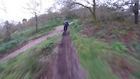
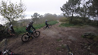
Photos of Galicia Mountain Bike
Videos of Galicia Mountain Bike
featured
![¡Descubre nuestras pistas! | Manzaneda Bike Park]()

0:51 |
493 |
Jun 19, 2022
trail: O Río
0:09 |
5 |
May 8, 2026

trail: O Río
0:09 |
6 |
May 8, 2026
trail: O Tendido
0:10 |
4 |
May 7, 2026
trail: Cantera
0:10 |
20 |
Mar 14, 2025
trail: Clásica 2
0:24 |
|
Mar 21, 2024
trail: Clásica 1
0:21 |
|
Mar 21, 2024
trail: La Rancherita - Intro
0:33 |
|
Mar 21, 2024
Current Trail Warnings
| status | trail | date | condition | user | info |
|---|---|---|---|---|---|
| Festuca Manzaneda Bike Park | Jun 13, 2026 @ 10:29am (Europe/Madrid) Jun 13, 2026 | Very Dry | Djpedrosa | E-Bike | |
| O Capataz Ortegal | Jun 12, 2026 @ 3:08pm (Europe/Madrid) Jun 12, 2026 | Ideal | mendr1ck | Prácticamente cerrada por la maleza, una... | |
| Jabato Monte Santa Trega | Jun 7, 2026 @ 5:13pm (Europe/Lisbon) Jun 7, 2026 | Dry | verbalius | muy vegetación no final |
Recent Trail Reports
National Scenic Trails & Official Routes
-
GR 58 Sendeiro das Greas
- Mountain Bike
- E-Bike
- Hike
- Trail Running
-
GR-65 Camino de Santiago
- Mountain Bike
- E-Bike
- Hike
- Trail Running

Activity Feed
| username | action | type | title | date |
|---|---|---|---|---|
| Mudelos | add | trail | activity #97208511 | Jun 17, 2026 @ 2:06pm 4 hours |
| CarloswJyLdB | wishlist | region | activity #97143494 | Jun 16, 2026 @ 4:01pm 1 day |
| atejer00 | add | report | activity #97140492 and 9 more | Jun 16, 2026 @ 3:13pm 1 day |
| Mudelos | add | trail | activity #97061953 and 1 more | Jun 15, 2026 @ 1:15pm 2 days |
| mattiapic | add | report | activity #97025660 | Jun 14, 2026 @ 11:54pm 3 days |
Recent Comments
| username | type | title | comment | date |
|---|---|---|---|---|
| trail | En recuperación… | Jun 12, 2026 @ 11:17am Jun 12, 2026 | ||
| trail | Ok | Apr 27, 2026 @ 12:56pm Apr 27, 2026 | ||
| report | Limpio y en buen estado... | Apr 25, 2026 @ 10:35am Apr 25, 2026 | ||
| trail | Senda muy bonita pero sin limpiar, una pena.... | Apr 18, 2026 @ 1:41pm Apr 18, 2026 | ||
| trail | Bajada con mucho flow, saltos adsequibles para... | Apr 12, 2026 @ 3:24pm Apr 12, 2026 |
Local Badges
-
Osdosacho Terminator9 awarded -

Completionist0 awarded -
Completionist0 awarded -
Completionist0 awarded -
Completionist0 awarded -
Completionist0 awarded
Bike & Skill Parks
| name | type | city | rating |
|---|---|---|---|
| Manzaneda Bike Park | bike park | Pobra De Trives | |
| Lucus Bikepark | bike park | Cristimil | |
| Pumptrack As Pontes | skill park | As Pontes | |
| Dirtpark Cedeira | skill park | Chapela | |
| Pumptrack Vialia | skill park | Vigo |
Upcoming Local Events
Activity Type Stats
| activitytype | trails | distance | descent | descent distance | total vertical | rating | global rank | state rank | photos | reports | routes | ridelogs |
|---|---|---|---|---|---|---|---|---|---|---|---|---|
| Mountain Bike | 3,717 | 2,667 miles | 556,211 ft | 1,367 miles | 6,870 ft | 873 | 5,389 | 111 | 68,998 | |||
| E-Bike | 3,604 | 2,581 miles | 537,838 ft | 1,321 miles | 6,870 ft | 4 | 5,260 | 105 | 6,340 | |||
| Gravel Bike | 33 | 23 miles | 2,933 ft | 10 miles | 5,751 ft | 1 | 155 | 45 | 512 | |||
| Adaptive Bike | 158 | 184 miles | 18,455 ft | 75 miles | 5,758 ft | 152 | 3 | 2 | ||||
| Winter Fat Bike | 11 | 7 miles | 820 ft | 3 miles | 1,677 ft | 70 | ||||||
| Horse | 95 | 88 miles | 15,207 ft | 42 miles | 3,314 ft | 408 | 6 | |||||
| Hike | 3,463 | 2,571 miles | 508,271 ft | 1,294 miles | 6,880 ft | 4 | 5,012 | 48 | 4,590 | |||
| Trail Running | 3,465 | 2,571 miles | 508,753 ft | 1,295 miles | 6,880 ft | 5,017 | 48 | 1,583 | ||||
| Dirtbike/Moto | 39 | 31 miles | 6,181 ft | 17 miles | 2,182 ft | 401 | 2 | |||||
| ATV/ORV/OHV | 2 | 2 miles | 249 ft | 1 mile | 157 ft | 396 | 1 | |||||
| Downhill Ski | 6 | 2 miles | 1,053 ft | 2 miles | 751 ft | 10 |
Activities
Trails
Points of Interest
- Mirador da Terra Chá Viewpoint
- Geodésico Ombreiro Summit
- Monte Penarrubia Summit
- Iroite Summit
- Muiños Rego das Cunchas Other
- San Lois Summit
- Monte Enxa Summit
- Puente Medieval Bridge
- Mirador do Iroite Viewpoint
- Rampas de Manizales TTF
- Cabeza de Manzaneda (5,810 ft)
- Sixtral (5,794 ft)
- Altos das Malladas (5,705 ft)
- By coletassoft & contributors
- Admins: mul0w, elyari, AMG, juanx, Angelreing, marcossantamaria
- #5040 - 16,264 views
- galicia activity log | embed map of Galicia mountain bike trails | galicia mountain biking points of interest polygons
Downloading of trail gps tracks in kml & gpx formats is enabled for Galicia.
You must login to download files.