close
-
Layers w
- Weather Layers
- Pro
- Pro
- Pro
- Pro
- Pro
- Pro
- More Layers
- Pro
- Pro
- Pro
- Pro
-
Upgrade to

3D
Trail Conditions
- Unknown
- Snow Groomed
- Snow Packed
- Snow Covered
- Snow Cover Partial
- Freeze/thaw Cycle
- Icy
- Prevalent Mud
- Wet
- Variable
- Ideal
- Dry
- Very Dry
Trail Flow (Ridden Direction)
Trailforks scans users ridelogs to determine the most popular direction each trail is ridden. A good flowing trail network will have most trails flowing in a single direction according to their intension.
The colour categories are based on what percentage of riders are riding a trail in its intended direction.
The colour categories are based on what percentage of riders are riding a trail in its intended direction.
- > 96%
- > 90%
- > 80%
- > 70%
- > 50%
- < 50%
- bi-directional trail
- no data
Trail Last Ridden
Trailforks scans ridelogs to determine the last time a trail was ridden.
- < 2 days
- < 1 week
- < 2 weeks
- < 1 month
- < 6 months
- > 6 months
Trail Ridden Direction
The intended direction a trail should be ridden.
- Downhill Only
- Downhill Primary
- Both Directions
- Uphill Primary
- Uphill Only
- One Direction
Contribute Details
Colors indicate trail is missing specified detail.
- Description
- Photos
- Description & Photos
- Videos
Trail Popularity ?
Trailforks scans ridelogs to determine which trails are ridden the most in the last 9 months.
Trails are compared with nearby trails in the same city region with a possible 25 colour shades.
Think of this as a heatmap, more rides = more kinetic energy = warmer colors.
- most popular
- popular
- less popular
- not popular
ATV/ORV/OHV Filter
Max Vehicle Width
inches
US Cell Coverage
Legend

Radar Time
Activity Recordings
Trailforks uses anonymized public activity data.
?
Activity Recordings
Trailforks uses anonymized public activity data.
?
Personal Heatmap
▶
Activity Types
all
/
none
▶
Options
2
Date range
month
–
Winter Trails
Warning
A routing network for winter maps does not exist. Selecting trails using the winter trails layer has been disabled.
Missing Trails
Most Popular
Least Popular
Trails are colored based on popularity. The more popular a trail is, the more red. Less popular trails trend towards green.
Jump Magnitude Heatmap
Heatmap of where riders jump on trails. Zoom in to see individual jumps, click circles to view jump details.
BC Backroad Status
![map legend]()
Service Road Atlas is a free to use, community-driven service for viewing and creating reports on the numerous back-country service roads around B.C. and Alberta.

Slope Aspect
Direction the slope faces
Trails Deemphasized
Trails are shown in grey.
Only show trails with no bike usage.
Suggested Layers
Based on selected activity type
Save the current map location and zoom level as your default home location whenever this page is loaded.
SaveVarious trails can be found in this region.
Activities Click to view
- Mountain Bike
125 trails
- Gravel Bike
2 trails
- Adaptive Bike
1 trails
- Winter Fat Bike
0 trails
- Hike
133 trails
- Trail Running
133 trails
Region Details
- 26
- 4
- 78
- 5
Region Status
Caution as of Jun 14, 2026Local Trail Association
Stats
- Avg Trail Rating
- Trails (view details)
- 113
- Trails Mountain Bike
- 133
- Trails Gravel Bike
- 2
- Trails Adaptive Bike
- 1
- Trails Horse
- 2
- Trails Hike
- 133
- Trails Trail Running
- 133
- Trails Snowshoe
- 1
- Trails Nordic Ski
- 1
- Total Distance
- 53 miles
- Total Descent
- 2,250 ft
- Total Vertical
- 105 ft
- Highest Trailhead
- 113 ft
- Reports
- 1,026
- Photos
- 278
- Ridden Counter
- 4,125
Sub Regions
-
Absegami Trails
- 2
-
Forsythe Wildlife Refuge
- 2
-
Galloway Nature Preserve
- 2
- 1
-
Landfill trails
- 6
-
Pomona Trails
- 1
-
Seaview Trails
- 24
- 2
-
Smithville Trails
- 1
- 1
-
Stockton University
- 3
- 42
- 2
Popular Galloway Mountain Biking Trails
• 90 ★ 4.0 • 1 mile • 36 ft • 118 •
addition to utilize some of the elevation between access road and , making a complete loop. There is also an optional A-line with a wooden drop.
• 95 ★ 3.7 • 2,260 ft • 10 ft • 117 •
Popular green difficulty doubletrack. This mountain bike primary trail can be used both directions and has a easy overall physical rating with a 10 ft green climb. On average it takes 2 minutes to complete this trail.
• 90 ★ 3.7 • 1,549 ft • 5 ft • 115 •
Popular green difficulty doubletrack. This mountain bike primary trail can be used both directions and has a easy overall physical rating with a 5 ft green climb. On average it takes 1 minutes to complete this trail.
• 100 ★ 3.7 • 2 miles • 43 ft • 111 •
Flowy singletrack just a couple miles from Stockton University. Part of a larger trail system in the area and the first of many new trails to get developed.
• 95 ★ 4.4 • 2,989 ft • 3 ft • 110 •
Highly rated popular green difficulty singletrack. This mountain bike primary trail can be used both directions and has a easy overall physical rating with a 3 ft green climb. On average it takes 3 minutes to complete this trail.
• 90 ★ 3.8 • 3,796 ft • 30 ft • 110 •
Popular green difficulty singletrack. This mountain bike primary trail can be used both directions and has a easy overall physical rating with a 30 ft green climb. On average it takes 4 minutes to complete this trail.
Galloway Mountain Bike Routes
2 miles • 58 ft • 6 • Loop •
A short route with some interesting trail to do intervals on.
7 miles • 87 ft • 7 •
Outer loop of Stockton University. Mostly double track trail with a few single track trails mixed in.
9 miles • 102 ft • 51 •
This is a basic lap of Stockton with a couple of extra bits. You can add on to this loop at various points.
• 18 miles • 365 ft • 26 •
• 7 miles • 201 ft • 9 •
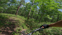
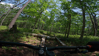
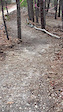
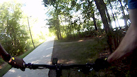
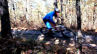
Photos of Galloway Mountain Bike
Videos of Galloway Mountain Bike
trail: Lost & Found
0:13 |
32 |
Jul 8, 2025
trail: Lost & Found
0:08 |
20 |
Jul 8, 2025
trail: Blue Trail
0:57 |
157 |
Apr 10, 2025
trail: NS Lake Fred
0:48 |
119 |
Jun 19, 2015
trail: Snake Run
0:20 |
279 |
Oct 31, 2013

trail: NS Lake Fred
3:00 |
108 |
Sep 15, 2024 , Galloway
2:20:57 |
215 |
Jul 25, 2021
1:20:02 |
376 |
Jun 12, 2021
Recent Trail Reports
| status | trail | date | condition | info | user |
|---|---|---|---|---|---|
| Blue Trail | Jun 14, 2026 @ 1:23pm (America/New_York) Jun 14, 2026 | Ideal | AbeFroman462 | ||
| Rim Loop | Jun 14, 2026 @ 1:23pm (America/New_York) Jun 14, 2026 | Ideal | AbeFroman462 | ||
| Orange Trail | Jun 14, 2026 @ 1:23pm (America/New_York) Jun 14, 2026 | Ideal | AbeFroman462 | ||
| Baiters Loop | Jun 3, 2026 @ 4:40pm (America/New_York) Jun 3, 2026 | Unknown | kakeret JORBA Atlantic | ||
| Great Creek to Landfill | May 13, 2026 @ 12:44pm (America/New_York) May 13, 2026 | Ideal | AbeFroman462 | ||
| Great Creek | May 13, 2026 @ 12:44pm (America/New_York) May 13, 2026 | Ideal | AbeFroman462 | ||
| North/South Connector | May 13, 2026 @ 12:44pm (America/New_York) May 13, 2026 | Ideal | AbeFroman462 | ||
| Lost & Found | May 13, 2026 @ 12:44pm (America/New_York) May 13, 2026 | Ideal | AbeFroman462 | ||
| Nucleus | Apr 28, 2026 @ 4:12pm (America/New_York) Apr 28, 2026 | Dry | kakeret JORBA Atlantic | ||
| Nature trail | Apr 15, 2026 @ 6:59pm (America/Vancouver) Apr 15, 2026 | Dry | logicwavelength |
Activity Feed
| username | action | type | title | date |
|---|---|---|---|---|
| crosschainbreakers | ridden | trail | activity #97193603 | Jun 17, 2026 @ 10:21am 1 day |
| AbeFroman462 | add | report | activity #96993565 and 2 more | Jun 14, 2026 @ 12:07pm Jun 14, 2026 |
| AbeFroman462 | add | report | activity #96457165 and 1 more | Jun 7, 2026 @ 7:09am Jun 7, 2026 |
| brettpalumbo | update | trail | activity #96446637 | Jun 7, 2026 @ 4:36am Jun 7, 2026 |
| AbeFroman462 | add | report | activity #96381536 and 2 more | Jun 6, 2026 @ 9:47am Jun 6, 2026 |
Recent Comments
| username | type | title | comment | date |
|---|---|---|---|---|
| report | Yeah, ngl… I was hoping for that. That’ll... | May 22, 2026 @ 7:30am May 22, 2026 | ||
| report | So much more to come! Goal is to continue the... | May 22, 2026 @ 7:19am May 22, 2026 | ||
| report | Loving that new trail. Ty. Flows so nice. And... | May 22, 2026 @ 7:06am May 22, 2026 | ||
| report | Excited for this section to be ready! | Jan 11, 2026 @ 9:02am Jan 11, 2026 | ||
| report | Thanks for helping out! | Dec 28, 2025 @ 8:37am Dec 28, 2025 |
Local Badges
-

Seaview Jerkins Steps7 awarded -

10 Green Trails93 awarded -

Epic Ride Climb 2k0 awarded -

Climbing 10k Badge7 awarded -

Climbing 100k Badge0 awarded -

Epic Ride Descent 2k0 awarded
Activity Type Stats
| activitytype | trails | distance | descent | descent distance | total vertical | rating | global rank | state rank | photos | reports | routes | ridelogs |
|---|---|---|---|---|---|---|---|---|---|---|---|---|
| Mountain Bike | 125 | 53 miles | 2,251 ft | 17 miles | 105 ft | #1,732 | #637 | 287 | 1,033 | 5 | 5,309 | |
| Gravel Bike | 2 | #690 | #1,199 | 30 | 7 | |||||||
| Adaptive Bike | 1 | #609 | #1,884 | 4 | 1 | |||||||
| Horse | 2 | 4 miles | 118 ft | 4,022 ft | 46 ft | 635 | 1 | |||||
| Hike | 133 | 53 miles | 2,251 ft | 17 miles | 105 ft | #3,825 | #1,354 | 1,034 | 1 | 337 | ||
| Trail Running | 133 | 53 miles | 2,251 ft | 17 miles | 105 ft | #3,343 | #985 | 1,034 | 1 | 76 | ||
| Snowshoe | 1 | 3 miles | 23 ft | 971 ft | 13 ft | 2 | 8 | |||||
| Nordic Ski | 1 | 3 miles | 23 ft | 971 ft | 13 ft | 2 | 1 |
Frequently Asked Questions About Galloway
▼
What are the best places to ride in Galloway?
Galloway has 8 areas to explore for mountain biking. The top rated areas are:
▼
What are the highest rated mountain biking trails in Galloway?
The highest rated mountain biking trails in Galloway are:
- Enchanted Forest (4.2/5)
- Lumpy Loop (4/5)
- Sand Trap (4/5)
- Lost Pine (4/5)
- Orange Trail (4/5)
▼
What is the best time of the year to ride in Galloway?
Based on ride log data, the most popular months to ride in Galloway are:
- July (132 activities)
- September (131 activities)
- August (130 activities)
▼
Where can I park to ride in Galloway?
There are 12 parking locations listed in Galloway. The most popular parking spots are: View all parking and trailhead locations on the map to plan your visit.
Trails
- By gerrycreighton
 WMBC staff & contributors
 - Admins: JORBA, JARJORBA, JORBA Atlantic
- #5415 - 7,436 views
- galloway activity log | embed map of Galloway mountain bike trails | galloway mountain biking points of interest polygons
Downloading of trail gps tracks in kml & gpx formats is enabled for Galloway.
You must login to download files.