close
-
Layers w
- Weather Layers
- Pro
- Pro
- Pro
- Pro
- Pro
- Pro
- More Layers
- Pro
- Pro
- Pro
- Pro
-
Upgrade to

3D
Trail Conditions
- Unknown
- Snow Groomed
- Snow Packed
- Snow Covered
- Snow Cover Partial
- Freeze/thaw Cycle
- Icy
- Prevalent Mud
- Wet
- Variable
- Ideal
- Dry
- Very Dry
Trail Flow (Ridden Direction)
Trailforks scans users ridelogs to determine the most popular direction each trail is ridden. A good flowing trail network will have most trails flowing in a single direction according to their intension.
The colour categories are based on what percentage of riders are riding a trail in its intended direction.
The colour categories are based on what percentage of riders are riding a trail in its intended direction.
- > 96%
- > 90%
- > 80%
- > 70%
- > 50%
- < 50%
- bi-directional trail
- no data
Trail Last Ridden
Trailforks scans ridelogs to determine the last time a trail was ridden.
- < 2 days
- < 1 week
- < 2 weeks
- < 1 month
- < 6 months
- > 6 months
Trail Ridden Direction
The intended direction a trail should be ridden.
- Downhill Only
- Downhill Primary
- Both Directions
- Uphill Primary
- Uphill Only
- One Direction
Contribute Details
Colors indicate trail is missing specified detail.
- Description
- Photos
- Description & Photos
- Videos
Trail Popularity ?
Trailforks scans ridelogs to determine which trails are ridden the most in the last 9 months.
Trails are compared with nearby trails in the same city region with a possible 25 colour shades.
Think of this as a heatmap, more rides = more kinetic energy = warmer colors.
- most popular
- popular
- less popular
- not popular
ATV/ORV/OHV Filter
Max Vehicle Width
inches
US Cell Coverage
Legend

Radar Time
Activity Recordings
Trailforks uses anonymized public activity data.
?
Activity Recordings
Trailforks uses anonymized public activity data.
?
Personal Heatmap
▶
Activity Types
all
/
none
▶
Options
2
Date range
month
–
Winter Trails
Warning
A routing network for winter maps does not exist. Selecting trails using the winter trails layer has been disabled.
Missing Trails
Most Popular
Least Popular
Trails are colored based on popularity. The more popular a trail is, the more red. Less popular trails trend towards green.
Jump Magnitude Heatmap
Heatmap of where riders jump on trails. Zoom in to see individual jumps, click circles to view jump details.
BC Backroad Status
![map legend]()
Service Road Atlas is a free to use, community-driven service for viewing and creating reports on the numerous back-country service roads around B.C. and Alberta.

Slope Aspect
Direction the slope faces
Trails Deemphasized
Trails are shown in grey.
Only show trails with no bike usage.
Suggested Layers
Based on selected activity type
Save the current map location and zoom level as your default home location whenever this page is loaded.
Save
No description for Garmisch has been added yet!
Login or register to submit one.
This region uses the Uk/Euro style trail grading system.
Activities Click to view
- Mountain Bike
132 trails
- E-Bike
130 trails
- Adaptive Bike
0 trails
- Winter Fat Bike
0 trails
- Hike
134 trails
- Trail Running
133 trails
Region Details
- 39
- 15
- 24
- 1
- 6
Region Status
Open as of Jun 15, 2026Stats
- Avg Trail Rating
- Trails (view details)
- 137
- Trails Mountain Bike
- 132
- Trails E-Bike
- 130
- Trails Hike
- 134
- Trails Trail Running
- 133
- Trails Backcountry Ski
- 3
- Total Distance
- 207 miles
- Total Descent
- 100,147 ft
- Total Vertical
- 7,458 ft
- Highest Trailhead
- 9,648 ft
- Reports
- 667
- Photos
- 199
- Ridden Counter
- 4,417
Sub Regions
-
Garmisch Area
- 15
- 22
- 1
- 6
Popular Garmisch Mountain Biking Trails
• 95 ★ 3.8 • 2 miles • 123 ft • 129 •
Moderate trail down from Enningalm to Rotmoosalm. Some fairly easy switchbacks. Has been used for years by mountainbikers as part of a circuit tour. Often followed by an ascent back up to the Stepbergalm and one of the trails there.
• 80 ★ 3.9 • 3,642 ft • 0 ft • 111 •
Popular blue difficulty singletrack. This mountain bike primary trail can be used downhill primary. It features rock garden and other. On average it takes 8 minutes to complete this trail.
• 100 ★ 4.8 • 3 miles • 137 ft • 102 •
Alpine trail with some slightly tighter hairpins and some rocky parts that can usually be rolled. In the beginning some pedaling fora bout 5 minutes to get to the highest point, a few short push up sections in the beginning, then...
• 95 ★ 4.5 • 1 mile • 0 ft • 98 •
Continuation from the trail. Much easier and less technical and exposed than the upper part. Still full of switchbacks but with some flowy sections as well. The trail ends with a speedy, fun section with some natural berms and small jumps.
• 70 ★ 3.4 • 2,774 ft • 27 ft • 97 •
Popular blue difficulty singletrack. This mountain bike primary trail can be used downhill primary. It features drop, rock garden and other. On average it takes 9 minutes to complete this trail.
• 100 ★ 4.5 • 2,221 ft • 0 ft • 95 •
Easier ending to the Schafkopf trail versus the path straight down.
• 100 ★ 3.9 • 3,153 ft • 0 ft • 72 •
Easy alternative on the Schafkopf mountain ending at the lower part of the regular Schafkopf trail, which logically follows. Can be ridden after the trail from Giessenbach Sattel or by itself. Not used by hikers as much as the main...
Garmisch Mountain Bike Routes
Photos of Garmisch Mountain Bike
Videos of Garmisch Mountain Bike
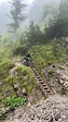
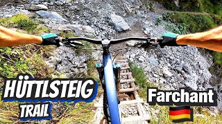
trail: Hüttlsteig
0:09 |
124 |
May 29, 2023

trail: Mid-Wank Connector
28:12 |
40 |
Sep 10, 2025 , Garmisch
trail: Wank Around
28:12 |
56 |
Sep 10, 2025 , Garmisch

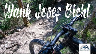
trail: Wank Josef Bichl
28:12 |
60 |
Sep 10, 2025 , Garmisch

trail: Hüttlsteig
28:12 |
74 |
Sep 10, 2025 , Garmisch
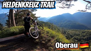
trail: Heldenkreuztrail
19:42 |
109 |
Feb 26, 2025 , Garmisch
youtuber
![GARMISCH BAYRISCHE ALPEN Enningalm Rotmoos...]()
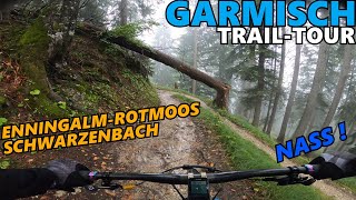
trail: Enning Alm Rotmoos
14:27 |
506 |
Jun 17, 2022 , Garmisch
trail: Wank Josef Bichl
2:33 |
499 |
Apr 29, 2022 , Garmisch
Recent Trail Reports
| status | trail | date | condition | info | user |
|---|---|---|---|---|---|
| Enning Alm Rotmoos | Jun 15, 2026 @ 11:22am (Europe/Vaduz) Jun 15, 2026 | Variable | Benni23186 | ||
| Enning Alm Access Road | Jun 15, 2026 @ 11:22am (Europe/Vaduz) Jun 15, 2026 | Ideal | Benni23186 | ||
| Easy Skanking | Jun 15, 2026 @ 11:22am (Europe/Vaduz) Jun 15, 2026 | Ideal | Benni23186 | ||
| Twisted Sheep | Jun 4, 2026 @ 12:33pm (Europe/Vaduz) Jun 4, 2026 | Variable | ChiliPalmer | ||
| Mid-Wank Connector | May 29, 2026 @ 9:32am (Europe/Vaduz) May 29, 2026 | Ideal | nod0 | ||
| Hüttlsteig | May 29, 2026 @ 9:32am (Europe/Vaduz) May 29, 2026 | Ideal | nod0 | ||
| Esterbergalm Access | May 29, 2026 @ 9:32am (Europe/Vaduz) May 29, 2026 | Ideal | nod0 | ||
| Reintal Access | May 30, 2026 @ 10:00am (Europe/Vaduz) May 30, 2026 | Ideal | nod0 | ||
| Gschwandtner Bauer | May 27, 2026 @ 10:57pm (Europe/Berlin) May 27, 2026 | Ideal | Grieg | ||
| Kreuzweg Trail | May 26, 2026 @ 8:43pm (Europe/Berlin) May 26, 2026 | Ideal | Ferdl |
Activity Feed
| username | action | type | title | date |
|---|---|---|---|---|
| Benni23186 | add | report | activity #97041631 and 2 more | Jun 15, 2026 @ 8:01am Jun 15, 2026 |
| Grieg | difficultyvote | trail | activity #96925437 and 1 more | Jun 13, 2026 @ 4:35pm Jun 13, 2026 |
| Grieg | add | photo | activity #96921620 and 11 more | Jun 13, 2026 @ 3:36pm Jun 13, 2026 |
| Grieg | comment | trail | activity #96920274 and 2 more | Jun 13, 2026 @ 3:16pm Jun 13, 2026 |
| Grieg | ridden | trail | activity #96920122 and 2 more | Jun 13, 2026 @ 3:15pm Jun 13, 2026 |
Recent Comments
| username | type | title | comment | date |
|---|---|---|---|---|
| trail | Der soll schwarz sein? Grün wäre passend.... | Jun 13, 2026 @ 3:19pm Jun 13, 2026 | ||
| trail | Niemals s3… keine blaue Fahrt. Mit ebike... | Jun 13, 2026 @ 3:18pm Jun 13, 2026 | ||
| trail | Definitiv ein Kas. S1-2 haut nicht hin. Viele... | Jun 13, 2026 @ 3:16pm Jun 13, 2026 | ||
| trail | It's suitable for both directions, and I'd say... | Jun 4, 2026 @ 8:27am Jun 4, 2026 | ||
| trail | Updated difficulty to red due to comments. | May 10, 2026 @ 11:09pm May 10, 2026 |
Local Badges
-

Epic Ride Descent 2k100 awarded -

Descent 100k Badge1 awarded -

Descent 10k Badge21 awarded -

Big Ride 30k370 awarded -

Mountain Biking 100k Badge1 awarded -

Climbing 10k Badge20 awarded
Activity Type Stats
| activitytype | trails | distance | descent | descent distance | total vertical | rating | global rank | state rank | photos | reports | routes | ridelogs |
|---|---|---|---|---|---|---|---|---|---|---|---|---|
| Mountain Bike | 132 | 194 miles | 98,566 ft | 111 miles | 7,457 ft | #723 | #4 | 196 | 665 | 1 | 3,063 | |
| E-Bike | 130 | 24 miles | 17,119 ft | 18 miles | 4,619 ft | #1,693 | #32 | 2 | 518 | 484 | ||
| Hike | 134 | 199 miles | 98,517 ft | 111 miles | 7,457 ft | #684 | #9 | 657 | 1,852 | |||
| Trail Running | 133 | 193 miles | 97,710 ft | 110 miles | 7,457 ft | #546 | #8 | 1 | 654 | 261 | ||
| Backcountry Ski | 3 | 4 miles | 46 ft | 1,109 ft | 3,642 ft | 1 | 320 |
Frequently Asked Questions About Garmisch
▼
What are the best places to ride in Garmisch?
Garmisch has 1 areas to explore for mountain biking. The top rated areas are:
▼
What are the highest rated mountain biking trails in Garmisch?
The highest rated mountain biking trails in Garmisch are:
- Kreuzweg Trail (4.5/5)
- Schafkopf Lower (4.3/5)
- Hasenjoch to Rossalm (4.3/5)
- Schafkopf Upper (4.3/5)
- Schafkopf Easier Ending (4.3/5)
▼
What is the best time of the year to ride in Garmisch?
Based on ride log data, the most popular months to ride in Garmisch are:
- July (45 activities)
- August (36 activities)
- October (35 activities)
▼
Where can I park to ride in Garmisch?
There are 9 parking locations listed in Garmisch. The most popular parking spots are: View all parking and trailhead locations on the map to plan your visit.
Activities
Trails
- By Bauchbert & contributors
- Admins: larry81541
- #45703 - 14,536 views
- garmisch activity log | embed map of Garmisch mountain bike trails | garmisch mountain biking points of interest
Downloading of trail gps tracks in kml & gpx formats is enabled for Garmisch.
You must login to download files.