close
-
Layers w
- Weather Layers
- Pro
- Pro
- Pro
- Pro
- Pro
- Pro
- More Layers
- Pro
- Pro
- Pro
- Pro
-
Upgrade to

3D
Trail Conditions
- Unknown
- Snow Groomed
- Snow Packed
- Snow Covered
- Snow Cover Partial
- Freeze/thaw Cycle
- Icy
- Prevalent Mud
- Wet
- Variable
- Ideal
- Dry
- Very Dry
Trail Flow (Ridden Direction)
Trailforks scans users ridelogs to determine the most popular direction each trail is ridden. A good flowing trail network will have most trails flowing in a single direction according to their intension.
The colour categories are based on what percentage of riders are riding a trail in its intended direction.
The colour categories are based on what percentage of riders are riding a trail in its intended direction.
- > 96%
- > 90%
- > 80%
- > 70%
- > 50%
- < 50%
- bi-directional trail
- no data
Trail Last Ridden
Trailforks scans ridelogs to determine the last time a trail was ridden.
- < 2 days
- < 1 week
- < 2 weeks
- < 1 month
- < 6 months
- > 6 months
Trail Ridden Direction
The intended direction a trail should be ridden.
- Downhill Only
- Downhill Primary
- Both Directions
- Uphill Primary
- Uphill Only
- One Direction
Contribute Details
Colors indicate trail is missing specified detail.
- Description
- Photos
- Description & Photos
- Videos
Trail Popularity ?
Trailforks scans ridelogs to determine which trails are ridden the most in the last 9 months.
Trails are compared with nearby trails in the same city region with a possible 25 colour shades.
Think of this as a heatmap, more rides = more kinetic energy = warmer colors.
- most popular
- popular
- less popular
- not popular
ATV/ORV/OHV Filter
Max Vehicle Width
inches
US Cell Coverage
Legend

Radar Time
Activity Recordings
Trailforks uses anonymized public activity data.
?
Activity Recordings
Trailforks uses anonymized public activity data.
?
Personal Heatmap
▶
Activity Types
all
/
none
▶
Options
2
Date range
month
–
Winter Trails
Warning
A routing network for winter maps does not exist. Selecting trails using the winter trails layer has been disabled.
Missing Trails
Most Popular
Least Popular
Trails are colored based on popularity. The more popular a trail is, the more red. Less popular trails trend towards green.
Jump Magnitude Heatmap
Heatmap of where riders jump on trails. Zoom in to see individual jumps, click circles to view jump details.
BC Backroad Status
![map legend]()
Service Road Atlas is a free to use, community-driven service for viewing and creating reports on the numerous back-country service roads around B.C. and Alberta.

Slope Aspect
Direction the slope faces
Trails Deemphasized
Trails are shown in grey.
Only show trails with no bike usage.
Suggested Layers
Based on selected activity type
Save the current map location and zoom level as your default home location whenever this page is loaded.
Save
No description for Garopaba has been added yet!
Login or register to submit one.
Activities Click to view
- Mountain Bike
10 trails
- E-Bike
13 trails
- Hike
11 trails
- Trail Running
9 trails
Region Details
- 1
- 4
- 3
- 1
Region Status
Caution as of Jun 21, 2026Stats
- Avg Trail Rating
- Trails (view details)
- 11
- Trails Mountain Bike
- 12
- Trails E-Bike
- 13
- Trails Horse
- 2
- Trails Hike
- 11
- Trails Trail Running
- 9
- Trails Dirtbike/Moto
- 2
- Trails Observed Trials
- 1
- Total Distance
- 19 miles
- Total Descent
- 4,877 ft
- Total Vertical
- 2,016 ft
- Highest Trailhead
- 2,031 ft
- Reports
- 29
- Photos
- 27
- Ridden Counter
- 180
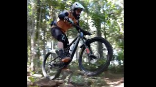
Popular Garopaba Mountain Biking Trails
• 65 ★ 0.0 • 3,120 ft • 10 ft • 19 •
Esta Trilha te leva até o Vale da Utopia, possui algumas cercas que devem ser mantidas como estavam, abertas ou fechadas. Por favor respeite essas condições. O visual da trilha é incrível, aos finais de semana durante a temporada...
• 45 ★ 3.5 • 8 miles • 2,367 ft • 11 •
Travessia do Siriu Norte até a Cascata Encantada.
• 55 ★ 0.0 • 2,060 ft • 139 ft • 10 •
Essa trilha nos leva de volta ao portal de entrada da Trilha do Maço. Possui algumas cercas que devem ser mantidas da forma que estão, abertas ou fechadas. This trail takes us back to the gateway to the Maço Trail. It has some fences...
• 100 ★ 5.0 • 771 ft • 0 ft • 8 •
Popular blue difficulty singletrack. This mountain bike primary trail can be used downhill only. It features berm, bridge, drop, jump and rock face. Trail visibility is always easy to follow.
• 95 ★ 5.0 • 1,322 ft • 0 ft • 7 •
Popular black diamond difficulty singletrack. This mountain bike primary trail can be used downhill only. It features berm, bridge, drop, jump, gap jump, ladder bridge, rock face and rock garden. Trail visibility is always easy to follow.
• 5 ★ 5.0 • 5 miles • 2,160 ft •
Trilha da Pera é uma das Big Line clássicas da grande Florianópolis. Descida flow e constante. Ou subida longa e gradativa. Trilha amplamente frequentada por motociclistas off road. Por este motivo muitas valas para transpor. Seja...
Photos of Garopaba Mountain Bike
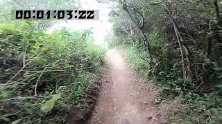
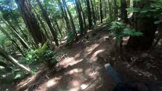
Videos of Garopaba Mountain Bike

0:56 |
21 |
Oct 13, 2025 , Garopaba
trail: Mini Freeride
2:02 |
72 |
Jun 21, 2024 , Garopaba
trail: FlowLine
0:52 |
57 |
Jun 21, 2024 , Garopaba
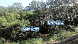
trail: Rustica
2:05 |
72 |
Jun 21, 2024 , Garopaba
trail: Surfline
0:38 |
64 |
Jun 21, 2024 , Garopaba
trail: Trilha dos Cavalos
0:12 |
150 |
Oct 24, 2021 , Garopaba
trail: Trilha dos Cavalos
0:19 |
142 |
Oct 24, 2021 , Garopaba

trail: Trilha da Pera
16:20 |
161 |
May 2, 2021 , Garopaba
Recent Trail Reports
| status | trail | date | condition | info | user |
|---|---|---|---|---|---|
| Surfline | Feb 17, 2026 @ 4:48pm (America/Sao_Paulo) Feb 17, 2026 | Ideal | Gustavotomasi | ||
| Rustica | Nov 12, 2025 @ 10:53am (America/Sao_Paulo) Nov 12, 2025 | Unknown | DRBranco | ||
| FlowLine | Nov 12, 2025 @ 10:53am (America/Sao_Paulo) Nov 12, 2025 | Ideal | DRBranco | ||
| Mini Freeride | Nov 12, 2025 @ 10:53am (America/Sao_Paulo) Nov 12, 2025 | Ideal | DRBranco | ||
| Trilha do Vale da Utopia | Oct 12, 2024 @ 9:22am Oct 12, 2024 | Ideal | DRBranco |
Activity Feed
| username | action | type | title | date |
|---|---|---|---|---|
| Gustavotomasi | add | report | activity #89256538 | Feb 20, 2026 @ 6:51pm Feb 20, 2026 |
| cerbaro | comment | trail | activity #88718383 | Feb 11, 2026 @ 3:58am Feb 11, 2026 |
| DRBranco | add | report | activity #84026920 and 3 more | Nov 12, 2025 @ 9:42am Nov 12, 2025 |
| bonepeeler | wishlist | trail | activity #82865622 and 1 more | Oct 23, 2025 @ 5:31am Oct 23, 2025 |
| Alessandrogbs | vote | trail | activity #79996973 | Sep 9, 2025 @ 11:37am Sep 9, 2025 |
Recent Comments
| username | type | title | comment | date |
|---|---|---|---|---|
| trail | Ainda tá aberto o acesso? | Feb 11, 2026 @ 3:58am Feb 11, 2026 | ||
| trail | Opção sem saltos e gaps para treinar curvas... | Jun 21, 2024 @ 11:11am Jun 21, 2024 | ||
| trail | Super flow, com mini rockgarden e dois step-ups. | Jun 21, 2024 @ 11:09am Jun 21, 2024 | ||
| trail | A free ride ficou animal! 3 saltos de dirt, um... | May 10, 2024 @ 7:32pm May 10, 2024 | ||
| report | O trecho entre o topo do Fortunato que desce... | Oct 11, 2023 @ 3:53am Oct 11, 2023 |
Local Badges
-

Epic Ride Descent 2k0 awarded -

Descent 10k Badge0 awarded -

Descent 100k Badge0 awarded
Activity Type Stats
| activitytype | trails | distance | descent | descent distance | total vertical | rating | global rank | state rank | photos | reports | routes | ridelogs |
|---|---|---|---|---|---|---|---|---|---|---|---|---|
| Mountain Bike | 10 | 16 miles | 3,045 ft | 5 miles | 2,011 ft | #3,602 | #42 | 38 | 36 | 1,687 | ||
| E-Bike | 13 | 18 miles | 4,613 ft | 8 miles | 2,011 ft | #2,944 | #57 | 1 | 33 | 111 | ||
| Horse | 2 | 7 miles | 1,824 ft | 3 miles | 2,005 ft | |||||||
| Hike | 11 | 19 miles | 4,879 ft | 8 miles | 2,018 ft | #5,109 | #69 | 5 | 36 | 81 | ||
| Trail Running | 9 | 18 miles | 4,833 ft | 8 miles | 2,018 ft | #4,647 | #74 | 36 | 1 | 59 | ||
| Dirtbike/Moto | 2 | 7 miles | 1,824 ft | 3 miles | 2,005 ft | 1 | ||||||
| Observed Trials | 1 | 5 miles | 256 ft | 4,278 ft | 1,939 ft |
Frequently Asked Questions About Garopaba
▼
What are the highest rated mountain biking trails in Garopaba?
The highest rated mountain biking trails in Garopaba are:
- Surfline (4.1/5)
- FlowLine (4.1/5)
- Rustica (4.1/5)
- Mini Freeride (4.1/5)
- Trilha da Pera (4.1/5)
▼
What is the best time of the year to ride in Garopaba?
Based on ride log data, the most popular months to ride in Garopaba are:
- November (4 activities)
- January (2 activities)
- April (2 activities)
▼
Where can I park to ride in Garopaba?
Check the Garopaba trail map for trailhead and parking information. Community members regularly update access and parking details for trails in the area.
▼
What is the longest trail in Garopaba?
The longest trail in Garopaba is Trilha dos Cavalos at 13.6 km. View all trails sorted by distance.
- By Gustavotomasi & contributors
- Admins: NataGiacomozzi, felipepimpao, NataGiacomozzi
- #20755 - 2,439 views
- garopaba activity log | embed map of Garopaba mountain bike trails |
Downloading of trail gps tracks in kml & gpx formats is enabled for Garopaba.
You must login to download files.