close
-
Layers w
- Weather Layers
- Pro
- Pro
- Pro
- Pro
- Pro
- Pro
- More Layers
- Pro
- Pro
- Pro
- Pro
-
Upgrade to

3D
Trail Conditions
- Unknown
- Snow Groomed
- Snow Packed
- Snow Covered
- Snow Cover Partial
- Freeze/thaw Cycle
- Icy
- Prevalent Mud
- Wet
- Variable
- Ideal
- Dry
- Very Dry
Trail Flow (Ridden Direction)
Trailforks scans users ridelogs to determine the most popular direction each trail is ridden. A good flowing trail network will have most trails flowing in a single direction according to their intension.
The colour categories are based on what percentage of riders are riding a trail in its intended direction.
The colour categories are based on what percentage of riders are riding a trail in its intended direction.
- > 96%
- > 90%
- > 80%
- > 70%
- > 50%
- < 50%
- bi-directional trail
- no data
Trail Last Ridden
Trailforks scans ridelogs to determine the last time a trail was ridden.
- < 2 days
- < 1 week
- < 2 weeks
- < 1 month
- < 6 months
- > 6 months
Trail Ridden Direction
The intended direction a trail should be ridden.
- Downhill Only
- Downhill Primary
- Both Directions
- Uphill Primary
- Uphill Only
- One Direction
Contribute Details
Colors indicate trail is missing specified detail.
- Description
- Photos
- Description & Photos
- Videos
Trail Popularity ?
Trailforks scans ridelogs to determine which trails are ridden the most in the last 9 months.
Trails are compared with nearby trails in the same city region with a possible 25 colour shades.
Think of this as a heatmap, more rides = more kinetic energy = warmer colors.
- most popular
- popular
- less popular
- not popular
ATV/ORV/OHV Filter
Max Vehicle Width
inches
US Cell Coverage
Legend

Radar Time
Activity Recordings
Trailforks uses anonymized public activity data.
?
Activity Recordings
Trailforks uses anonymized public activity data.
?
Personal Heatmap
▶
Activity Types
all
/
none
▶
Options
2
Date range
month
–
Winter Trails
Warning
A routing network for winter maps does not exist. Selecting trails using the winter trails layer has been disabled.
Missing Trails
Most Popular
Least Popular
Trails are colored based on popularity. The more popular a trail is, the more red. Less popular trails trend towards green.
Jump Magnitude Heatmap
Heatmap of where riders jump on trails. Zoom in to see individual jumps, click circles to view jump details.
BC Backroad Status
![map legend]()
Service Road Atlas is a free to use, community-driven service for viewing and creating reports on the numerous back-country service roads around B.C. and Alberta.

Slope Aspect
Direction the slope faces
Trails Deemphasized
Trails are shown in grey.
Only show trails with no bike usage.
Suggested Layers
Based on selected activity type
Save the current map location and zoom level as your default home location whenever this page is loaded.
SaveGeorgia is divided into the official tourism regions of the state as per the attached file below. These are the sub-regions 1.
North Georgia Region
Atlanta Metro Region
Central Georgia Region
South Georgia Region
Coastal Georgia Region.
Eash of these Regions are further divided into the counties that make up the Region, as sub-regions 2.
North Georgia Region
Atlanta Metro Region
Central Georgia Region
South Georgia Region
Coastal Georgia Region.
Eash of these Regions are further divided into the counties that make up the Region, as sub-regions 2.
source: County Map
Files
- Geographic_Regional_Map_(1).pdf (2.63 MB)
Region Details
- 796
- 33
- 701
- 620
- 178
- 31
- 2
Stats
- Avg Trail Rating
- Trails (view details)
- 3,146
- Trails Mountain Bike
- 2,373
- Trails E-Bike
- 858
- Trails Gravel Bike
- 184
- Trails Adaptive Bike
- 257
- Trails Winter Fat Bike
- 51
- Trails Horse
- 331
- Trails Hike
- 2,926
- Trails Trail Running
- 2,863
- Trails Dirtbike/Moto
- 59
- Trails Observed Trials
- 3
- Trails ATV/ORV/OHV
- 55
- Trails Snowshoe
- 1
- Trails Backcountry Ski
- 1
- Total Distance
- 3,791 miles
- Total Descent
- 445,889 ft
- Total Vertical
- 5,421 ft
- Highest Trailhead
- 5,421 ft
- Reports
- 16,696
- Photos
- 4,374
- Ridden Counter
- 281,189
Articles

Hurricane Damage Forced Hikers Off the Appalachian Trail. These Southern Thru-Hikes Are Ready to Welcome Them.
Oct 25, 2024 from backpacker.com
After Hurricane Helene, large swathes of North Carolina and Tennessee’s Appalachian Trail were left devastated. Some hikers are looking to these...
Ditch the AT's Crowds on the Benton MacKaye Trail
Jun 5, 2023 from backpacker.com
This short shuttle hike explores the southernmost section of the Benton MacKaye Trail, which links the Georgia backcountry to the northern reaches...

Race Report: The 2023 Big Creek Quick Six Enduro
Oct 23, 2023 from pinkbike.com
RAMBO's recap from this weekend's event.
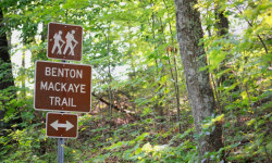
Meet the Other "Appalachian Trail" That Could Become Our Next National Scenic Trail
Jun 5, 2023 from backpacker.com
The Benton MacKaye Trail Starts at the AT's southern terminus and runs nearly 300 miles through the hills—and a bipartisan bill is set to name...
Sub Regions
- Atlanta Metro Region (502)
- Clayton County (8)
- Cobb County (147)
- DeKalb County (43)
- Douglas County (7)
- Fayette County (14)
- Fulton County (147)
- Gwinnett County (94)
- Henry County (3)
- Paulding County (32)
- Rockdale County (17)
- Central Georgia Region (653)
- Baldwin County (39)
- Bibb County (51)
- Burke County (1)
- Butts County (72)
- Candler County (1)
- Chattahoochee County (16)
- Clarke County (30)
- Columbia County (26)
- Coweta County (29)
- Crawford County (1)
- Crisp County (7)
- Dooley County (1)
- Emanuel County (6)
- Glascock County (1)
- Greene County (16)
- Hancock County (1)
- Harris County (3)
- Heard County (1)
- Houston County (21)
- Jasper County (104)
- Jefferson County (1)
- Jenkins County (14)
- Johnson County (1)
- Jones County (65)
- Lamar County (1)
- Lincoln County (1)
- Macon County (1)
- Marion County (1)
- McDuffie County (1)
- Meriwether County (9)
- Monroe County (1)
- Morgan County (10)
- Muscogee County (77)
- Newton County (1)
- Oconee County (13)
- Oglethorpe County (8)
- Peach County (1)
- Pike County (1)
- Putnam County (12)
- Richmond County (9)
- Schley County (1)
- Spalding County (7)
- Stewart County (2)
- Sumter County (1)
- Talbot County (1)
- Taliaferro County (11)
- Taylor County (1)
- Troup County (23)
- Twiggs County (1)
- Upson County (1)
- Walton County (1)
- Warren County (1)
- Washington County (1)
- Webster County (1)
- Wilkes County (1)
- Wilkinson County (1)
- Coastal Georgia Region (78)
- Chatham County (68)
- Glynn County (10)
- North Georgia Region (1,045)
- Banks County (1)
- Barrow County (57)
- Bartow County (52)
- Carroll County (33)
- Catoosa County (1)
- Chatooga County (107)
- Cherokee County (51)
- Dade County (34)
- Dawson County (25)
- Elbert County (1)
- Fannin County (35)
- Floyd County (140)
- Forsyth County (26)
- Franklin County (12)
- Gilmer County (131)
- Gordon County (3)
- Habersham County (35)
- Hall County (37)
- Haralson County (1)
- Hart County (2)
- Jackson County (3)
- Lumpkin County (68)
- Madison County (11)
- Murray County (39)
- Pickens County (15)
- Polk County (13)
- Rabun County (13)
- Stephens County (16)
- Towns County (5)
- Union County (13)
- Walker County (38)
- White County (35)
- Whitfield County (84)
- South Georgia Region (67)
- Appling County (1)
- Baker County (1)
- Bleckley County (1)
- Calhoun County (1)
- Clay County (1)
- Coffee County (9)
- Colquitt County (1)
- Decatur County (6)
- Dodge County (1)
- Dougherty (7)
- Early County (1)
- Evans County (1)
- Grady County (0)
- Jeff Davis County (1)
- Laurens County (1)
- Lee County (1)
- Lowndes County (7)
- Miller County (1)
- Mitchell County (1)
- Montgomery County (1)
- Pulaski County (1)
- Quitman County (1)
- Randolph County (1)
- Seminole County (1)
- Tatnall County (1)
- Telfair County (1)
- Terrell County (1)
- Thomas County (3)
- Toombs County (1)
- Treutlen County (1)
- Ware County (7)
- Wayne County (1)
- Wheeler County (1)
- Wilcox County (1)
- Worth County (1)
Popular Georgia Mountain Biking Trails
• 100 ★ 4.3 • 4 miles • 383 ft • 1,649 •
4.2 Miles (Intermediate) The is our most popular and most ridden trail. A true contour-trail, Dwelling brings in all the elements of singletrack in our area: Rocks, roots and some elevation changes. In general, this is a fast flowing XC...
• 100 ★ 4.5 • 1,870 ft • 52 ft • 1,585 •
Designed by Scott Stewart, this upper leg option of descends into some gnarly root ledge drops to work your suspension.
• 90 ★ 4.4 • 3 miles • 499 ft • 1,515 •
3.4 Miles (Advanced) brings the amplitude. This machine-cut trail is relatively smooth but sweeps up and down several peaks on the west side of the park. Switchback and berm turns abound and a good speed can be maintained on VMT by the...
• 90 ★ 3.0 • 3,301 ft • 27 ft • 1,375 •
This is a two-way trail that provides a easy way to get to the Flow Trails and Mason's Loop.
• 95 ★ 3.0 • 2,228 ft • 3 ft • 1,330 •
This is a short doubletrack connector trail from the main lot that provides access to . You can use to reach the , and then from you can connect into .
• 95 ★ 4.7 • 971 ft • 45 ft • 1,283 •
The takes you from the Dwelling trail head to the top of .
• 85 ★ 4.3 • 2,365 ft • 37 ft • 1,275 •
The advanced Alt-Line trail on Dwelling has been expanded with two downhill flow options, Rock and Roll and Rhythm and Blues. Rock and Roll has high speed turns, jumps and gully wall rides that connect back to the Dwelling main loop and...
• 100 ★ 4.3 • 4 miles • 444 ft • 1,237 •
Highly rated popular blue difficulty singletrack. This multi-use trail can be used both directions and has a moderate overall physical rating with a 444 ft blue climb. Trail visibility is always easy to follow. On average it takes 35 minutes to complete this trail.
Georgia Mountain Bike Routes
Thomson Full Black Loop Featured
★ 4.0 • 6 miles • 367 ft • 8 • Loop •
Thomson Black Loop. Follows the Black Arrows and its the entire trail system. Trail rating is actually...
Sandbox (Blue Loop) Featured
★ 5.0 • 4 miles • 248 ft • 5 • Loop •
Thomson Blue Loop. Follows the blue arrows
Pig Trail Yellow Loop Featured
5 miles • 251 ft • 3 •
Yellow Loop at Pig Trail. This route takes parts of the balck, blue, and green loops to make an enjoyable...
Thomson Black Loop Featured
5 miles • 306 ft • 9 • Loop •
The is the black loop minus Jake n Brake. This is kinda the OG black loop that most of the locals ride....
Green Loop Featured
★ 5.0 • 1 mile • 55 ft • 2 •
Green Loop @ Thomson. This is a 1 mile loop that is easy for beginners.
The Piggie Featured
12 miles • 592 ft • 7 • Loop •
This route incorporates the Green Loop with the and the entire Black Loop. This route starts off easy by...
Videos of Georgia Mountain Bike

trail: Air Supply
0:15 |
23 |
May 12, 2026

trail: Unlimited Breadsticks
0:20 |
31 |
Jul 18, 2025

trail: Typhoon
0:13 |
105 |
May 24, 2025
trail: Air Supply
0:00 |
61 |
May 3, 2025
trail: Local Pro
0:03 |
|
Jan 24, 2025
trail: Cyclone Gallop
0:17 |
|
Dec 31, 2024

trail: Typhoon
0:24 |
103 |
Nov 28, 2024

trail: Lower Backwoods
0:20 |
61 |
Nov 13, 2024
National Scenic Trails & Official Routes
-
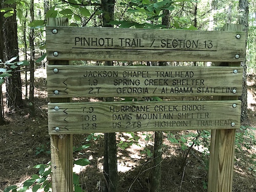
Pinhoti Trail (Georgia)
- Mountain Bike
- Hike
- Trail Running
-
River To Clouds
- Mountain Bike
- E-Bike
- Hike
- Trail Running

Activity Feed
| username | action | type | title | date |
|---|---|---|---|---|
| DankerSix5 | ridden | trail | activity #97452863 | Jun 20, 2026 @ 8:26pm 1 hours |
| anythingbike | add | karma | activity #97432717 | Jun 20, 2026 @ 2:19pm 7 hours |
| GorillaMTB | add | report | activity #97426360 | Jun 20, 2026 @ 1:07pm 8 hours |
| theburninator133 | wishlist | route | activity #97421320 | Jun 20, 2026 @ 12:11pm 9 hours |
| BAnderson104 | add | report | activity #97413506 | Jun 20, 2026 @ 10:54am 11 hours |
Recent Comments
| username | type | title | comment | date |
|---|---|---|---|---|
| trail | I’d rate as a single black with the... | Jun 20, 2026 @ 10:25am 11 hours | ||
| report | Hugh tree down on at least 30’ of trail. | Jun 17, 2026 @ 2:56pm Jun 17, 2026 | ||
| report | Cleared | Jun 17, 2026 @ 7:27am Jun 17, 2026 | ||
| trail | It’s a lovely little trail and nice to get... | Jun 8, 2026 @ 7:12am Jun 8, 2026 | ||
| trail | It’s the only game in town and grateful for... | Jun 4, 2026 @ 7:29pm Jun 4, 2026 |
Local Badges
-

10 Green Trails215 awarded -

Top 10 Trails0 awarded -

Epic Ride Climb 2k13 awarded -
Epic Ride Climb 2k14 awarded -
Epic Ride Climb 2k2 awarded -

Climbing 10k Badge25 awarded
Bike & Skill Parks
| name | type | city | rating |
|---|---|---|---|
| Jarrod's Place | bike park | Summerville | |
| Allatoona Creek Bike Park & Skills Area | skill park | Acworth | |
| Fannin County Motocross Park | skill park | ||
| Pumptrack | skill park | Roswell | |
| Walker Park Pump Track & Skills park | skill park | Athens |
Activity Type Stats
| activitytype | trails | distance | descent | descent distance | total vertical | rating | global rank | state rank | photos | reports | routes | ridelogs |
|---|---|---|---|---|---|---|---|---|---|---|---|---|
| Mountain Bike | 2,369 | 2,836 miles | 279,954 ft | 1,124 miles | 4,157 ft | #31 | 3,688 | 16,636 | 140 | 337,577 | ||
| E-Bike | 858 | 1,035 miles | 90,745 ft | 410 miles | 4,157 ft | #33 | 24 | 13,600 | 33 | 18,361 | ||
| Gravel Bike | 184 | 323 miles | 20,197 ft | 127 miles | 3,547 ft | #33 | 6 | 1,156 | 11 | 1,761 | ||
| Adaptive Bike | 257 | 424 miles | 34,656 ft | 166 miles | 3,268 ft | #28 | 1,000 | 6 | ||||
| Winter Fat Bike | 51 | 88 miles | 9,764 ft | 37 miles | 1,598 ft | #44 | 1 | 1,999 | 3 | |||
| Horse | 331 | 453 miles | 45,085 ft | 169 miles | 4,209 ft | #36 | 2,332 | 4 | 89 | |||
| Hike | 2,926 | 3,623 miles | 418,894 ft | 1,453 miles | 5,420 ft | #34 | 519 | 16,384 | 17 | 21,736 | ||
| Trail Running | 2,863 | 3,555 miles | 406,207 ft | 1,422 miles | 5,420 ft | #33 | 44 | 16,365 | 17 | 14,502 | ||
| Dirtbike/Moto | 59 | 94 miles | 14,780 ft | 41 miles | 3,009 ft | #36 | 2,200 | 60 | ||||
| Observed Trials | 3 | 3 miles | 423 ft | 1 mile | 1,969 ft | #32 | 15 | 26 | ||||
| ATV/ORV/OHV | 55 | 80 miles | 14,098 ft | 37 miles | 2,408 ft | #37 | 1 | 2,184 | 72 | |||
| Snowshoe | 1 | 4 miles | 2,005 ft | 3 miles | 1,985 ft | #42 | 218 | 10 | ||||
| Backcountry Ski | 1 | 4 miles | 2,005 ft | 3 miles | 1,985 ft | #34 | 36 | 33 |
Activities
Trails
Points of Interest
- Bridge 5 TTF
- wood feature TTF
- Amicalola Falls Viewing Platform Viewpoint
- Stone Arch (Appalachian Trail) Sight
- Visitor's Center Information
- Beginners easy drop TTF
- Henry's Mill Falls Viewpoint
- Bridge 7 TTF
- Bridge 6 TTF
- 65 ft. log skinny TTF
- Brasstown Bald (1,458 m)
- Rabun Bald (1,432 m)
- Dicks Knob (1,407 m)
- By canadaka
 Trailforks & contributors
 - Admins: Map Team, IMBA, chuktA, msmcfate, WillieJacobsz, PlumbBobM, ReckitRolley, colinreuter, SORBA, lscarmic
- #3193 - 42,891 views
- georgia activity log | embed map of Georgia mountain bike trails | georgia mountain biking points of interest polygons
Downloading of trail gps tracks in kml & gpx formats is enabled for Georgia.
You must login to download files.