close
-
Layers w
- Weather Layers
- Pro
- Pro
- Pro
- Pro
- Pro
- Pro
- More Layers
- Pro
- Pro
- Pro
- Pro
-
Upgrade to

3D
Trail Conditions
- Unknown
- Snow Groomed
- Snow Packed
- Snow Covered
- Snow Cover Partial
- Freeze/thaw Cycle
- Icy
- Prevalent Mud
- Wet
- Variable
- Ideal
- Dry
- Very Dry
Trail Flow (Ridden Direction)
Trailforks scans users ridelogs to determine the most popular direction each trail is ridden. A good flowing trail network will have most trails flowing in a single direction according to their intension.
The colour categories are based on what percentage of riders are riding a trail in its intended direction.
The colour categories are based on what percentage of riders are riding a trail in its intended direction.
- > 96%
- > 90%
- > 80%
- > 70%
- > 50%
- < 50%
- bi-directional trail
- no data
Trail Last Ridden
Trailforks scans ridelogs to determine the last time a trail was ridden.
- < 2 days
- < 1 week
- < 2 weeks
- < 1 month
- < 6 months
- > 6 months
Trail Ridden Direction
The intended direction a trail should be ridden.
- Downhill Only
- Downhill Primary
- Both Directions
- Uphill Primary
- Uphill Only
- One Direction
Contribute Details
Colors indicate trail is missing specified detail.
- Description
- Photos
- Description & Photos
- Videos
Trail Popularity ?
Trailforks scans ridelogs to determine which trails are ridden the most in the last 9 months.
Trails are compared with nearby trails in the same city region with a possible 25 colour shades.
Think of this as a heatmap, more rides = more kinetic energy = warmer colors.
- most popular
- popular
- less popular
- not popular
ATV/ORV/OHV Filter
Max Vehicle Width
inches
US Cell Coverage
Legend

Radar Time
Activity Recordings
Trailforks uses anonymized public activity data.
?
Activity Recordings
Trailforks uses anonymized public activity data.
?
Personal Heatmap
▶
Activity Types
all
/
none
▶
Options
2
Date range
month
–
Winter Trails
Warning
A routing network for winter maps does not exist. Selecting trails using the winter trails layer has been disabled.
Missing Trails
Most Popular
Least Popular
Trails are colored based on popularity. The more popular a trail is, the more red. Less popular trails trend towards green.
Jump Magnitude Heatmap
Heatmap of where riders jump on trails. Zoom in to see individual jumps, click circles to view jump details.
BC Backroad Status
![map legend]()
Service Road Atlas is a free to use, community-driven service for viewing and creating reports on the numerous back-country service roads around B.C. and Alberta.

Slope Aspect
Direction the slope faces
Trails Deemphasized
Trails are shown in grey.
Only show trails with no bike usage.
Suggested Layers
Based on selected activity type
Save the current map location and zoom level as your default home location whenever this page is loaded.
Save
No description for Gibsons has been added yet!
Login or register to submit one.
Activities Click to view
- Mountain Bike
62 trails
- E-Bike
51 trails
- Gravel Bike
0 trails
- Adaptive Bike
0 trails
- Winter Fat Bike
0 trails
- Hike
69 trails
- Trail Running
69 trails
Region Details
- 8
- 16
- 27
- 10
Region Status
Open as of Jun 10, 2026Stats
- Avg Trail Rating
- Trails (view details)
- 61
- Trails Mountain Bike
- 63
- Trails E-Bike
- 51
- Trails Horse
- 1
- Trails Hike
- 69
- Trails Trail Running
- 69
- Trails Observed Trials
- 1
- Total Distance
- 21 miles
- Total Descent
- 8,950 ft
- Total Vertical
- 2,156 ft
- Highest Trailhead
- 2,426 ft
- Reports
- 1,044
- Photos
- 331
- Ridden Counter
- 25,990
Sub Regions
-
Sprockids
- 11
- 24
- 10
Popular Gibsons Mountain Biking Trails
• 100 ★ 4.5 • 2,493 ft • 0 ft • 2,512 •
This downhill trail, named in honour of Sprockids founder Doug Detweiler, was built by the Capilano University students starting in 2012 2012 under the guidance of instructors Jay Hoots and Daniel Scott. It can be reached just off of...
• 100 ★ 4.3 • 1,565 ft • 25 ft • 1,310 •
This downhill trail is one of the most popular trails on the coast for those just getting into mountain biking, although is a great ride at any level. It was built by the Capilano University students in the spring of 2013 under the...
• 95 ★ 4.4 • 1 mile • 523 ft • 1,264 •
Main connecting route in Sprockids to upper Sprockids trails and Hwy 102 to the B&K area
• 90 ★ 4.3 • 1,772 ft • 2 ft • 929 •
One of the most popular trails in the Sprockids region, is flowy, steep, fast, and filled with small jumps, berms, and a lot of twists and turns. It exits on to Technical Ecstacy, which you can use to link up to and for one of the most...
• 60 ★ 3.2 • 1,270 ft • 158 ft • 838 •
Suggested climbing route. Flume is a short trail that connects between the trail and Sidewinder. A little rough in places, but not too technical. Named after the old flume that used to run down to Langdale through here.
• 85 ★ 4.0 • 2,133 ft • 180 ft • 746 •
Best ridden from Spockids to Langdale and is the main off-road access to get to the ferry. Beautiful full bench cutting, bridges up and over yew trees and across Langdale Creek, this trail employs some pretty nifty know-how techniques.
• 90 ★ 4.3 • 738 ft • 0 ft • 739 •
A short short and steep DH trail built by the Capilano University Mountain Bike students in 2009 with the help and guidance of instructors Mark Schmidt and Jay Hoots. This trail branches off of midway and features some steep tight rock...
• 100 ★ 3.5 • 449 ft • 0 ft • 696 •
Popular green difficulty singletrack. This mountain bike primary trail can be used both directions. On average it takes minutes to complete this trail.
Gibsons Mountain Bike Routes
★ 4.5 • 17 miles • 4,009 ft • 48 • Loop •
This ride has a little bit of everything and will certainly get your legs moving after a week of sitting...
26 miles • 6,181 ft • 14 • Loop •
A fun longer ride from Langdale for those coming from Vancouver. Park in Horsehoe Bay and ride onto the...
★ 2.0 • 75 miles • 9,320 ft • 41 • Point to Point •
http://www.bikepacking.com/routes/bikepacking-lower-sunshine-coast/
★ 1.0 • 45 miles • 6,517 ft • 3 • Point to Point •
If you want to go for a couple laps while also doing a few days of bikepacking... this is a good route!
75 miles • 9,344 ft • 41 • Point to Point •
http://www.bikepacking.com/routes/bikepacking-lower-sunshine-coast/
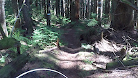
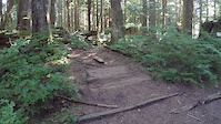
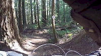
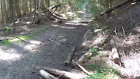
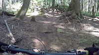
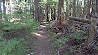
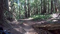
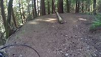
Photos of Gibsons Mountain Bike
Videos of Gibsons Mountain Bike
trail: Ridge
5:34 |
752 |
Sep 5, 2017
trail: Torrent
7:19 |
632 |
Sep 5, 2017
trail: Wildman
0:00 |
623 |
Sep 5, 2017
trail: Red Trail
4:52 |
281 |
Sep 5, 2017
trail: Wildman
3:16 |
154 |
Sep 5, 2017
trail: Wildman
3:44 |
102 |
Sep 5, 2017
trail: Wildman
3:14 |
76 |
Sep 5, 2017
trail: Wildman
3:55 |
82 |
Sep 5, 2017
Current Trail Warnings
| status | trail | date | condition | user | info |
|---|---|---|---|---|---|
| High Road | Jun 10, 2026 @ 10:31am (America/Vancouver) Jun 10, 2026 | Unknown | nodignoridemtb CMBTA | Closed at Westridge end due to active... | |
| Torrent | May 24, 2026 @ 7:26pm (America/Vancouver) May 24, 2026 | Dry | enki | Large tree down across trail, blocking trail |
Recent Trail Reports
| status | trail | date | condition | info | user |
|---|---|---|---|---|---|
| Sprockids Climb Trail | May 5, 2026 @ 6:50pm (America/Vancouver) May 5, 2026 | Dry | TheLongMan | ||
| Lunge Express | May 5, 2026 @ 6:50pm (America/Vancouver) May 5, 2026 | Dry | TheLongMan | ||
| Pineapple Express | May 5, 2026 @ 6:50pm (America/Vancouver) May 5, 2026 | Dry | TheLongMan | ||
| Creeker's Connectors | May 5, 2026 @ 6:50pm (America/Vancouver) May 5, 2026 | Dry | TheLongMan | ||
| Doug's Detention | May 5, 2026 @ 6:50pm (America/Vancouver) May 5, 2026 | Dry | TheLongMan | ||
| Blue Loop Trail | May 5, 2026 @ 6:50pm (America/Vancouver) May 5, 2026 | Dry | TheLongMan | ||
| Stinger | Apr 30, 2026 @ 9:12am (America/Vancouver) Apr 30, 2026 | Unknown | Mandy1815 | ||
| Ankle Biter | Apr 30, 2026 @ 8:52am (America/Vancouver) Apr 30, 2026 | Unknown | Mandy1815 | ||
| Fuzzy Hugs | Apr 5, 2026 @ 12:58pm (America/Vancouver) Apr 5, 2026 | Variable | 421coast | ||
| Lunge (Langdale Trail) | Apr 5, 2026 @ 12:58pm (America/Vancouver) Apr 5, 2026 | Ideal | 421coast |
Activity Feed
| username | action | type | title | date |
|---|---|---|---|---|
| dereksgehl | wishlist | region | activity #97222285 | Jun 17, 2026 @ 6:03pm Jun 17, 2026 |
| Kade17 | wishlist | region | activity #97168986 | Jun 17, 2026 @ 1:44am Jun 17, 2026 |
| benedetto973 | wishlist | route | activity #96725770 | Jun 11, 2026 @ 3:06am Jun 11, 2026 |
| nodignoridemtb | add | report | activity #96682504 | Jun 10, 2026 @ 10:32am Jun 10, 2026 |
| benedetto973 | wishlist | trail | activity #96587520 and 1 more | Jun 8, 2026 @ 11:35pm Jun 8, 2026 |
Recent Comments
| username | type | title | comment | date |
|---|---|---|---|---|
| trail | Hey ....The INGLIS trail, from the... | Mar 31, 2026 @ 8:27am Mar 31, 2026 | ||
| trail | Due to timber logging operations, access to... | Nov 20, 2025 @ 7:05pm Nov 20, 2025 | ||
| trail | big tree down - Oct 25 | Oct 25, 2025 @ 2:43pm Oct 25, 2025 | ||
| trail | There are a couple of trees down at the top... | Oct 23, 2025 @ 4:35pm Oct 23, 2025 | ||
| report | Is the trail on private land or crown land? | Sep 6, 2025 @ 12:36pm Sep 6, 2025 |
Local Badges
-

10 Blue Trails136 awarded -

Epic Ride Climb 2k1 awarded -

Climbing 10k Badge21 awarded -

Climbing 100k Badge0 awarded -

Epic Ride Descent 2k1 awarded -

Descent 10k Badge21 awarded
Activity Type Stats
| activitytype | trails | distance | descent | descent distance | total vertical | rating | global rank | state rank | photos | reports | routes | ridelogs |
|---|---|---|---|---|---|---|---|---|---|---|---|---|
| Mountain Bike | 62 | 21 miles | 8,950 ft | 11 miles | 2,156 ft | #1,470 | #59 | 301 | 1,044 | 29 | 9,622 | |
| E-Bike | 51 | 20 miles | 8,570 ft | 11 miles | 2,156 ft | #3,365 | #80 | 982 | 1 | 313 | ||
| Horse | 1 | 214 | 20 | |||||||||
| Hike | 69 | 20 miles | 7,736 ft | 10 miles | 2,156 ft | #2,565 | #85 | 27 | 1,011 | 1,203 | ||
| Trail Running | 69 | 20 miles | 7,736 ft | 10 miles | 2,156 ft | #4,364 | #106 | 1,011 | 621 | |||
| Observed Trials | 1 | 2 miles | 69 ft | 2,005 ft | 246 ft | 5 | 5 |
Frequently Asked Questions About Gibsons
▼
What are the best places to ride in Gibsons?
Gibsons has 2 areas to explore for mountain biking. The top rated areas are:
▼
What are the highest rated mountain biking trails in Gibsons?
The highest rated mountain biking trails in Gibsons are:
- Black Licorice (4.4/5)
- Sprockids Climb Trail (4.4/5)
- Doug's Detention (4.3/5)
- Ridge (4.3/5)
- Sidewinder (4.3/5)
▼
What is the best time of the year to ride in Gibsons?
Based on ride log data, the most popular months to ride in Gibsons are:
- July (145 activities)
- August (144 activities)
- June (116 activities)
▼
Where can I park to ride in Gibsons?
There are 3 parking locations listed in Gibsons. The most popular parking spots are: View all parking and trailhead locations on the map to plan your visit.
Activities
Trails
Points of Interest
- By Wabmatrix
 CMBTA & contributors
 - Admins: CMBTA, SCDBA
- #7514 - 18,020 views
- gibsons activity log | embed map of Gibsons mountain bike trails | gibsons mountain biking points of interest polygons
Downloading of trail gps tracks in kml & gpx formats is enabled for Gibsons.
You must login to download files.