close
-
Layers w
- Weather Layers
- Pro
- Pro
- Pro
- Pro
- Pro
- Pro
- More Layers
- Pro
- Pro
- Pro
- Pro
-
Upgrade to

3D
Trail Conditions
- Unknown
- Snow Groomed
- Snow Packed
- Snow Covered
- Snow Cover Partial
- Freeze/thaw Cycle
- Icy
- Prevalent Mud
- Wet
- Variable
- Ideal
- Dry
- Very Dry
Trail Flow (Ridden Direction)
Trailforks scans users ridelogs to determine the most popular direction each trail is ridden. A good flowing trail network will have most trails flowing in a single direction according to their intension.
The colour categories are based on what percentage of riders are riding a trail in its intended direction.
The colour categories are based on what percentage of riders are riding a trail in its intended direction.
- > 96%
- > 90%
- > 80%
- > 70%
- > 50%
- < 50%
- bi-directional trail
- no data
Trail Last Ridden
Trailforks scans ridelogs to determine the last time a trail was ridden.
- < 2 days
- < 1 week
- < 2 weeks
- < 1 month
- < 6 months
- > 6 months
Trail Ridden Direction
The intended direction a trail should be ridden.
- Downhill Only
- Downhill Primary
- Both Directions
- Uphill Primary
- Uphill Only
- One Direction
Contribute Details
Colors indicate trail is missing specified detail.
- Description
- Photos
- Description & Photos
- Videos
Trail Popularity ?
Trailforks scans ridelogs to determine which trails are ridden the most in the last 9 months.
Trails are compared with nearby trails in the same city region with a possible 25 colour shades.
Think of this as a heatmap, more rides = more kinetic energy = warmer colors.
- most popular
- popular
- less popular
- not popular
ATV/ORV/OHV Filter
Max Vehicle Width
inches
US Cell Coverage
Legend

Radar Time
Activity Recordings
Trailforks uses anonymized public activity data.
?
Activity Recordings
Trailforks uses anonymized public activity data.
?
Personal Heatmap
▶
Activity Types
all
/
none
▶
Options
2
Date range
month
–
Winter Trails
Warning
A routing network for winter maps does not exist. Selecting trails using the winter trails layer has been disabled.
Missing Trails
Most Popular
Least Popular
Trails are colored based on popularity. The more popular a trail is, the more red. Less popular trails trend towards green.
Jump Magnitude Heatmap
Heatmap of where riders jump on trails. Zoom in to see individual jumps, click circles to view jump details.
BC Backroad Status
![map legend]()
Service Road Atlas is a free to use, community-driven service for viewing and creating reports on the numerous back-country service roads around B.C. and Alberta.

Slope Aspect
Direction the slope faces
Trails Deemphasized
Trails are shown in grey.
Only show trails with no bike usage.
Suggested Layers
Based on selected activity type
Save the current map location and zoom level as your default home location whenever this page is loaded.
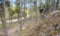
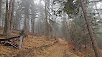
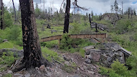
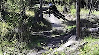
SaveBorn from the early days of freeride mountain biking, the Gillard Trail Network has become a legendary destination for riders seeking challenge and creativity. The area offers a wide variety of terrain — from fast singletrack and rocky technical sections to jumps, skinnies, slabs, and signature handcrafted woodwork. True to its roots, Gillard delivers a rugged, raw riding experience best suited for intermediate to expert riders.
With stunning views of Okanagan Lake and the surrounding valley, Gillard delivers a true mountain biking experience that blends natural beauty, challenge, and progression. Maintained in partnership with MTBCO and Recreation Sites and Trails BC, Gillard continues to evolve as a showcase of local trail stewardship and community passion.
Access by shuttling the main FSR or tackling the designated climbing trails for a full-value lap.
Primary Trail Type: All-Mountain & Downhill
eBikes Allowed:
Yes
Shuttleable: YES
Land Status: Crown Land
Land Manager: Rec Sites and Trail BC
 google parking directions
 Region Supporters & Maintainers
Activities Click to view
- Mountain Bike
79 trails
- E-Bike
77 trails
- Hike
10 trails
- Trail Running
12 trails
Region Details
- 12
- 1
- 27
- 18
- 16
Region Status
Open as of 17 hoursStats
- Avg Trail Rating
- Trails (view details)
- 74
- Trails Mountain Bike
- 79
- Trails E-Bike
- 77
- Trails Horse
- 1
- Trails Hike
- 10
- Trails Trail Running
- 12
- Trails Dirtbike/Moto
- 1
- Trails Observed Trials
- 1
- Trails ATV/ORV/OHV
- 1
- Total Distance
- 50 miles
- Total Descent
- 15,529 ft
- Total Vertical
- 3,389 ft
- Highest Trailhead
- 5,214 ft
- Reports
- 2,144
- Photos
- 621
- Ridden Counter
- 24,351
Articles

Details Announced For 'The Mega' Enduro at Gillard
Jan 19, 2026 from pinkbike.com
Race Enduro at Gillard on May 24th for 99 bucks or less.
Gillard Mega Enduro Race Announces 2025 Event Details
May 15, 2025 from pinkbike.com
A new grassroots enduro hits Kelowna.
Popular Gillard Mountain Biking Trails
• 95 ★ 4.6 • 2,897 ft • 11 ft • 1,057 •
has a mix of natural and wooden features. Fun fast and flowy with optional lines
• 100 ★ 4.2 • 1,365 ft • 45 ft • 942 •
Don't want to choke on dust while riding on the road? Try Oddjob. It's a bi-directional trail to move riders away from the traffic on the FSR. Enjoy some views of Bellevue Canyon while your at it.
• 95 ★ 4.1 • 1,388 ft • 2 ft • 838 •
is a true Gillard classic. Some big features, both natural and wood. All of which have ride arounds.
• 80 ★ 4.0 • 5 miles • 559 ft • 800 •
Popular green difficulty rail trail. This multi-use trail can be used both directions and has a easy overall physical rating with a 559 ft green climb. On average it takes 32 minutes to complete this trail.
• 90 ★ 4.2 • 1,089 ft • 0 ft • 726 •
Highly rated popular blue difficulty singletrack. This mountain bike primary trail can be used downhill only and has a moderate overall physical rating. On average it takes 2 minutes to complete this trail.
• 95 ★ 3.9 • 1,736 ft • 0 ft • 723 •
Freeride fun. Wooden features, dirt tables, skinnies, and finshes with a snaky bermed single track.
• 85 ★ 4.5 • 1 mile • 0 ft • 682 •
The Mooseknuckle is an all natural dirt and rock single track that rips through some beauty views and different forest sections. Natural hits, drops and rock sections. Ride it slow or fast and enjoy
• 100 ★ 4.5 • 5,023 ft • 405 ft • 614 •
Gillard's first climb trail. Plenty of challenging switch backs and couple steep punches. Overall an enjoyable experience with some nice views of Bellevue Canyon along the way.
Gillard Mountain Bike Routes
★ 5.0 • 5 miles • 1,794 ft • 5 • Point to Point •
The full official climb route from the parking lot to the KVR consisting of new climb trail built by MTBco...
★ 5.0 • 4 miles • 1,704 ft • 5 • Point to Point •
The full official climb route from the parking lot to the KVR consisting of new climb trail built by MTBco...
1 mile • 1 •
Riders will get to the top of . Timed Segment will go from Top of , until the end of .
4 miles • 1,004 ft • 1 • Loop •
For this Sovereign Cycle group ride, we're headed up the road to for a bit of speed! This trail offers...
29 miles • 4,465 ft • 35 •
Devilville Downhill - Climb Crawford trails to the KVR. Commute the KVR to the Gillard DH area, continue...
3 miles • 21 ft • 13 •
this is a route for Gillard as an easy route for people to get to know the area and learn about the nature...
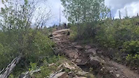
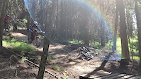
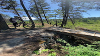
Photos of Gillard Mountain Bike
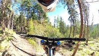
Videos of Gillard Mountain Bike
trail: The Therapist
0:13 |
37 |
Nov 15, 2025
trail: The Therapist
0:07 |
12 |
Nov 15, 2025
trail: Wobbly Pops
0:10 |
70 |
May 25, 2025
trail: Wobbly Pops
0:21 |
30 |
May 25, 2025
trail: Rubber Down
0:09 |
237 |
Oct 24, 2021
trail: The Therapist
0:17 |
371 |
Jun 3, 2021
trail: Boss Hogg
0:05 |
|
May 30, 2021
trail: The Therapist
0:34 |
210 |
May 29, 2021
Recent Trail Reports
| status | trail | date | condition | info | user |
|---|---|---|---|---|---|
| Fists First | Jul 2, 2026 @ 1:50pm (America/Vancouver) 17 hours | Unknown | ruby1 | ||
| Not Stirred Climb | Jun 23, 2026 @ 9:07am (America/Vancouver) Jun 23, 2026 | Dry | bikesrfun1 | ||
| Honey Ryder Climb | Jun 23, 2026 @ 9:06am (America/Vancouver) Jun 23, 2026 | Very Dry | bikesrfun1 | ||
| Blunicorn | Jun 23, 2026 @ 9:04am (America/Vancouver) Jun 23, 2026 | Dry | bikesrfun1 | ||
| Upper First Notch | Jun 14, 2026 @ 10:09am (America/Vancouver) Jun 14, 2026 | Unknown | h-gps | ||
| Rubber Down | Jun 7, 2026 @ 7:33pm (America/Vancouver) Jun 7, 2026 | Ideal | Wes-Barber | ||
| Boss Hogg | Jun 7, 2026 @ 7:31pm (America/Vancouver) Jun 7, 2026 | Ideal | Wes-Barber | ||
| Snake's Back | Jun 7, 2026 @ 7:31pm (America/Vancouver) Jun 7, 2026 | Dry | Wes-Barber | ||
| Upper Snake's Back | Jun 7, 2026 @ 7:31pm (America/Vancouver) Jun 7, 2026 | Ideal | Wes-Barber | ||
| Meeko | Jun 7, 2026 @ 7:30pm (America/Vancouver) Jun 7, 2026 | Ideal | Wes-Barber |
Activity Feed
| username | action | type | title | date |
|---|---|---|---|---|
| ruby1 | add | report | activity #98291556 | Jul 2, 2026 @ 1:50pm 17 hours |
| jdreid | wishlist | trail | activity #98227163 | Jul 1, 2026 @ 2:41pm 2 days |
| jdreid | ridden | trail | activity #98226532 | Jul 1, 2026 @ 2:30pm 2 days |
| TearaHEJdLI | wishlist | region | activity #98204242 | Jul 1, 2026 @ 8:55am 2 days |
| ZachdHSxMp | wishlist | route | activity #98200150 | Jul 1, 2026 @ 7:52am 2 days |
Recent Comments
| username | type | title | comment | date |
|---|---|---|---|---|
| trail | How is this running this year?! Full trail open? | Jun 15, 2026 @ 4:55pm Jun 15, 2026 | ||
| report | I Ukuh | May 23, 2026 @ 10:32am May 23, 2026 | ||
| report | Cleared | Mar 23, 2026 @ 10:14am Mar 23, 2026 | ||
| report | Ty Farrar | Mar 20, 2026 @ 9:47am Mar 20, 2026 | ||
| report | The answer | Mar 20, 2026 @ 9:46am Mar 20, 2026 |
Nearby Areas
| name | distance | ||||
|---|---|---|---|---|---|
| Thompson Flats | 6 | 1 | 1 | 2.9 km | |
| Crawford Trails | 26 | 64 | 18 | 3.7 km | |
| Kalamoir Regional Park | 4 | 7.6 km | |||
| Sutherland Hills | 13 | 8.3 km | |||
| Okanagan Mountain Park | 1 | 5 | 4 | 8.8 km |
Local Badges
-

Completionist0 awarded
Activity Type Stats
| activitytype | trails | distance | descent | descent distance | total vertical | rating | global rank | state rank | photos | reports | routes | ridelogs |
|---|---|---|---|---|---|---|---|---|---|---|---|---|
| Mountain Bike | 79 | 50 miles | 15,528 ft | 25 miles | 3,389 ft | #514 | #52 | 617 | 2,144 | 20 | 8,840 | |
| E-Bike | 77 | 50 miles | 15,528 ft | 25 miles | 3,389 ft | #1,710 | #64 | 1,631 | 8 | 975 | ||
| Horse | 1 | 5 miles | 561 ft | 2 miles | 144 ft | 292 | 1 | |||||
| Hike | 10 | 22 miles | 2,211 ft | 6 miles | 3,232 ft | #6,301 | #256 | 3 | 1,476 | 187 | ||
| Trail Running | 12 | 22 miles | 2,211 ft | 6 miles | 3,232 ft | #5,310 | 1 | 1,475 | 151 | |||
| Dirtbike/Moto | 1 | 5 miles | 561 ft | 2 miles | 144 ft | 295 | 29 | |||||
| Observed Trials | 1 | 5 miles | 561 ft | 2 miles | 144 ft | 5 | 1 | |||||
| ATV/ORV/OHV | 1 | 5 miles | 561 ft | 2 miles | 144 ft | 290 | 15 |
Frequently Asked Questions About Gillard
▼
What are the highest rated mountain biking trails in Gillard?
The highest rated mountain biking trails in Gillard are:
- Dr. No (4.7/5)
- Casino Royale (4.6/5)
- Rubber Down (4.6/5)
- Sanchez (4.5/5)
- The Therapist (4.5/5)
▼
What is the best time of the year to ride in Gillard?
Based on ride log data, the most popular months to ride in Gillard are:
- June (91 activities)
- May (82 activities)
- October (65 activities)
▼
Where can I park to ride in Gillard?
There are 1 parking locations listed in Gillard. The most popular parking spots are:
▼
What is the longest trail in Gillard?
The longest trail in Gillard is KVR - Gillard at 8.3 km. View all trails sorted by distance.
Activities
Trails
- By julien-downhill & contributors
- Admins: MTBco, MTBco, MTBco
- #2559 - 50,277 views
- gillard activity log | embed map of Gillard mountain bike trails | gillard mountain biking points of interest
Downloading of trail gps tracks in kml & gpx formats is enabled for Gillard.
You must login to download files.