close
-
Layers w
- Weather Layers
- Pro
- Pro
- Pro
- Pro
- Pro
- Pro
- More Layers
- Pro
- Pro
- Pro
- Pro
-
Upgrade to

3D
Trail Conditions
- Unknown
- Snow Groomed
- Snow Packed
- Snow Covered
- Snow Cover Partial
- Freeze/thaw Cycle
- Icy
- Prevalent Mud
- Wet
- Variable
- Ideal
- Dry
- Very Dry
Trail Flow (Ridden Direction)
Trailforks scans users ridelogs to determine the most popular direction each trail is ridden. A good flowing trail network will have most trails flowing in a single direction according to their intension.
The colour categories are based on what percentage of riders are riding a trail in its intended direction.
The colour categories are based on what percentage of riders are riding a trail in its intended direction.
- > 96%
- > 90%
- > 80%
- > 70%
- > 50%
- < 50%
- bi-directional trail
- no data
Trail Last Ridden
Trailforks scans ridelogs to determine the last time a trail was ridden.
- < 2 days
- < 1 week
- < 2 weeks
- < 1 month
- < 6 months
- > 6 months
Trail Ridden Direction
The intended direction a trail should be ridden.
- Downhill Only
- Downhill Primary
- Both Directions
- Uphill Primary
- Uphill Only
- One Direction
Contribute Details
Colors indicate trail is missing specified detail.
- Description
- Photos
- Description & Photos
- Videos
Trail Popularity ?
Trailforks scans ridelogs to determine which trails are ridden the most in the last 9 months.
Trails are compared with nearby trails in the same city region with a possible 25 colour shades.
Think of this as a heatmap, more rides = more kinetic energy = warmer colors.
- most popular
- popular
- less popular
- not popular
ATV/ORV/OHV Filter
Max Vehicle Width
inches
US Cell Coverage
Legend

Radar Time
Activity Recordings
Trailforks uses anonymized public activity data.
?
Activity Recordings
Trailforks uses anonymized public activity data.
?
Personal Heatmap
▶
Activity Types
all
/
none
▶
Options
2
Date range
month
–
Winter Trails
Warning
A routing network for winter maps does not exist. Selecting trails using the winter trails layer has been disabled.
Missing Trails
Most Popular
Least Popular
Trails are colored based on popularity. The more popular a trail is, the more red. Less popular trails trend towards green.
Jump Magnitude Heatmap
Heatmap of where riders jump on trails. Zoom in to see individual jumps, click circles to view jump details.
BC Backroad Status
![map legend]()
Service Road Atlas is a free to use, community-driven service for viewing and creating reports on the numerous back-country service roads around B.C. and Alberta.

Slope Aspect
Direction the slope faces
Trails Deemphasized
Trails are shown in grey.
Only show trails with no bike usage.
Suggested Layers
Based on selected activity type
Save the current map location and zoom level as your default home location whenever this page is loaded.
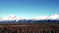
SaveGIRDWOOD, “Alaska’s best year round resort community” is located 4o minutes south of Anchorage. Travel south on the Seward Highway, a national scenic byway and breathtaking drive that winds along the edge of Turnagain Arm and is bordered by towering mountains on both sides.
Make Girdwood your summer and winter vacation home base.
Whether you are in Alaska on your own or with a group, staying in Girdwood makes perfect sense. There is a wide array of accommodations (500+ beds), concierge services, activity specialists, wonderful restaurants, and unique gift shops.
Special Services are provided our community by home remodelers, real estate specialists, website designers, internet marketers, and transportation providers.
source: http://www.girdwoodchamber.com/
AKA: GirdWeird
Links
Activities Click to view
- Mountain Bike
75 trails
- E-Bike
6 trails
- Gravel Bike
3 trails
- Adaptive Bike
0 trails
- Winter Fat Bike
0 trails
- Hike
53 trails
- Trail Running
48 trails
- Snowshoe
11 trails
- Downhill Ski
94 trails
- Backcountry Ski
10 trails
- Nordic Ski
18 trails
Region Details
- 11
- 16
- 27
- 18
- 3
Region Status
Open as of Jan 24, 2026Stats
- Avg Trail Rating
- Trails (view details)
- 169
- Trails Mountain Bike
- 75
- Trails E-Bike
- 6
- Trails Gravel Bike
- 3
- Trails Hike
- 53
- Trails Trail Running
- 48
- Trails Snowshoe
- 11
- Trails Downhill Ski
- 94
- Trails Backcountry Ski
- 10
- Trails Nordic Ski
- 18
- Total Distance
- 68 miles
- Total Descent
- 47,131 ft
- Total Vertical
- 2,950 ft
- Highest Trailhead
- 2,986 ft
- Reports
- 510
- Photos
- 137
- Ridden Counter
- 16,266
Sub Regions
-
Alyeska Bike Park
- 3
- 17
- 13
- 3
-
Alyeska Ski Resort
- 3
- 3
- 1
-
Girdwood Mountain Bike Park
- 2
- 1
-
Girdwood Nordic
- 9
- 4
- 2
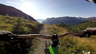
Popular Girdwood Mountain Biking Trails
• 100 ★ 4.0 • 519 ft • 11 ft • 187 •
Popular blue difficulty singletrack. This mountain bike primary trail can be used downhill only. It features berm. On average it takes minutes to complete this trail.
• 100 ★ 5.0 • 899 ft • 20 ft • 185 •
Popular blue difficulty singletrack. This mountain bike primary trail can be used downhill only. It features berm. On average it takes minutes to complete this trail.
• 80 ★ 4.0 • 2,346 ft • 0 ft • 184 •
Popular blue difficulty singletrack. This mountain bike primary trail can be used downhill only and has a moderate overall physical rating with a 0 ft green climb. It features berm. On average it takes 1 minutes to complete this trail.
• 95 ★ 5.0 • 1,736 ft • 0 ft • 182 •
Popular blue difficulty singletrack. This mountain bike primary trail can be used downhill only and has a moderate overall physical rating with a 0 ft green climb. It features berm and jump. On average it takes 1 minutes to complete this trail.
• 90 ★ 5.0 • 833 ft • 0 ft • 181 •
Popular black diamond difficulty singletrack. This mountain bike primary trail can be used downhill only and has a hard overall physical rating. It features berm. On average it takes minutes to complete this trail.
• 85 ★ 4.0 • 633 ft • 0 ft • 178 •
Popular blue difficulty singletrack. This mountain bike primary trail can be used downhill only. It features berm and jump. On average it takes minutes to complete this trail.
• 85 ★ 5.0 • 1,043 ft • 22 ft • 174 •
Popular blue difficulty singletrack. This mountain bike primary trail can be used downhill only and has a moderate overall physical rating with a 22 ft green climb. It features berm. On average it takes 1 minutes to complete this trail.
Photos of Girdwood Mountain Bike
Videos of Girdwood Mountain Bike
trail: Big Spruce
0:56 |
149 |
Aug 4, 2019
trail: Winner Creek Trail
0:36 |
192 |
Jun 22, 2019
trail: Fridays
0:31 |
283 |
Sep 24, 2018
trail: Winner Creek Trail
2:36 |
961 |
Jun 1, 2016

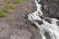
trail: Waterfall
3:31 |
579 |
Jul 12, 2021 , Girdwood

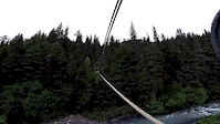
trail: Creek Crossing
0:00 |
554 |
Oct 12, 2020 , Girdwood
Recent Trail Reports
| status | trail | date | condition | info | user |
|---|---|---|---|---|---|
| Trapline Traverse | Jan 24, 2026 @ 7:48pm (America/Anchorage) Jan 24, 2026 | Unknown | OwenikxOM | ||
| Crow Creek to Hand Tram | Dec 25, 2025 @ 11:47am (America/Anchorage) Dec 25, 2025 | Icy | MR_LAK | ||
| INHT: Girdwood upper Iditarod trails | Aug 28, 2025 @ 9:04pm Aug 28, 2025 | Variable | ruckerstaggers | ||
| Bermuda Triangle | Jul 28, 2025 @ 4:31pm Jul 28, 2025 | Unknown | ryanmillet | ||
| Green Trail Loop | Jan 31, 2025 @ 12:03pm Jan 31, 2025 | Unknown | trailforks Trailforks | ||
| Abes | Oct 2, 2024 @ 7:29pm Oct 2, 2024 | Ideal | wolfdoodle5017 | ||
| Winner Creek Extention Connector | Aug 4, 2024 @ 4:10am Aug 4, 2024 | Ideal | bneffer | ||
| 2 cents | Aug 4, 2024 @ 4:10am Aug 4, 2024 | Variable | bneffer | ||
| Earnagain | Aug 4, 2024 @ 4:10am Aug 4, 2024 | Ideal | bneffer | ||
| 5K Nordic Loop | Aug 4, 2024 @ 4:10am Aug 4, 2024 | Ideal | bneffer |
Activity Feed
| username | action | type | title | date |
|---|---|---|---|---|
| markholloway | add | trail | activity #88803977 and 2 more | Feb 12, 2026 @ 3:41pm Feb 12, 2026 |
| OwenikxOM | add | report | activity #87769838 | Jan 24, 2026 @ 8:48pm Jan 24, 2026 |
| MR_LAK | add | report | activity #86066029 | Dec 25, 2025 @ 7:26pm Dec 25, 2025 |
| markholloway | update | trail | activity #85211867 | Dec 5, 2025 @ 9:31pm Dec 5, 2025 |
| markholloway | update | trail | activity #85211856 | Dec 5, 2025 @ 9:27pm Dec 5, 2025 |
Recent Comments
| username | type | title | comment | date |
|---|---|---|---|---|
| trail | One double black feature. It was sketchy and I... | Jul 28, 2025 @ 4:36pm Jul 28, 2025 | ||
| trail | Wish it was longer. Drops, tech, loam, and... | Jul 28, 2025 @ 4:34pm Jul 28, 2025 | ||
| trail | Best trail at the bike Park. Super fun.... | Jul 28, 2025 @ 4:33pm Jul 28, 2025 | ||
| trail | Super fun. Some small drops and excellent... | Jul 28, 2025 @ 4:33pm Jul 28, 2025 | ||
| trail | Sickest section in the bike park. She's chunky | Jul 28, 2025 @ 4:31pm Jul 28, 2025 |
Local Badges
-

10 Blue Trails108 awarded -

10 Black Trails44 awarded -

Epic Ride Climb 2k225 awarded -

Climbing 10k Badge31 awarded -

Climbing 100k Badge1 awarded -

Epic Ride Descent 2k330 awarded
Bike & Skill Parks
| name | type | city | rating |
|---|---|---|---|
| Alyeska Bike Park | bike park | Girdwood |
Activity Type Stats
| activitytype | trails | distance | descent | descent distance | total vertical | rating | global rank | state rank | photos | reports | routes | ridelogs |
|---|---|---|---|---|---|---|---|---|---|---|---|---|
| Mountain Bike | 75 | 44 miles | 16,837 ft | 24 miles | 2,720 ft | #2,100 | #752 | 135 | 508 | 3,540 | ||
| E-Bike | 6 | 1 mile | 404 ft | 4,114 ft | 748 ft | #7,653 | #2,308 | 360 | 174 | |||
| Gravel Bike | 3 | 4,406 ft | 974 ft | 4,124 ft | 682 ft | #582 | #1,116 | 13 | 3 | |||
| Hike | 53 | 39 miles | 12,871 ft | 20 miles | 2,720 ft | #4,394 | #1,548 | 1 | 498 | 2 | 1,473 | |
| Trail Running | 48 | 37 miles | 12,661 ft | 19 miles | 2,720 ft | #4,190 | #1,278 | 498 | 2 | 359 | ||
| Snowshoe | 11 | 6 miles | 525 ft | 3 miles | 381 ft | #816 | #376 | 2 | 7 | |||
| Downhill Ski | 94 | 23 miles | 30,292 ft | 22 miles | 2,677 ft | #161 | #67 | 2 | 4,985 | |||
| Backcountry Ski | 10 | 5 miles | 312 ft | 3 miles | 381 ft | #432 | #100 | 2 | 213 | |||
| Nordic Ski | 18 | 7 miles | 686 ft | 3 miles | 374 ft | #724 | #266 | 1 | 2 | 344 |
Frequently Asked Questions About Girdwood
▼
What are the best places to ride in Girdwood?
Girdwood has 4 areas to explore for mountain biking. The top rated areas are:
▼
What are the highest rated mountain biking trails in Girdwood?
The highest rated mountain biking trails in Girdwood are:
- SmallHouse (4.3/5)
- Canyon Lands (4.3/5)
- Abes (4.2/5)
- Blueberry Pancake Trail (4.2/5)
- Knoll Trees (4.2/5)
▼
What is the best time of the year to ride in Girdwood?
Based on ride log data, the most popular months to ride in Girdwood are:
- July (79 activities)
- August (50 activities)
- September (36 activities)
▼
Where can I park to ride in Girdwood?
Activities
Trails
- By mtnjnkie
 TRAILFORKS STA & contributors
 - Admins: CMBR, LeeBolling, forrestt30, JDUERParks, A-Lens-for-Wanderlust
- #14530 - 7,378 views
- girdwood activity log | embed map of Girdwood mountain bike trails | girdwood mountain biking points of interest
Downloading of trail gps tracks in kml & gpx formats is enabled for Girdwood.
You must login to download files.