close
-
Layers w
- Weather Layers
- Pro
- Pro
- Pro
- Pro
- Pro
- Pro
- More Layers
- Pro
- Pro
- Pro
- Pro
-
Upgrade to

3D
Trail Conditions
- Unknown
- Snow Groomed
- Snow Packed
- Snow Covered
- Snow Cover Partial
- Freeze/thaw Cycle
- Icy
- Prevalent Mud
- Wet
- Variable
- Ideal
- Dry
- Very Dry
Trail Flow (Ridden Direction)
Trailforks scans users ridelogs to determine the most popular direction each trail is ridden. A good flowing trail network will have most trails flowing in a single direction according to their intension.
The colour categories are based on what percentage of riders are riding a trail in its intended direction.
The colour categories are based on what percentage of riders are riding a trail in its intended direction.
- > 96%
- > 90%
- > 80%
- > 70%
- > 50%
- < 50%
- bi-directional trail
- no data
Trail Last Ridden
Trailforks scans ridelogs to determine the last time a trail was ridden.
- < 2 days
- < 1 week
- < 2 weeks
- < 1 month
- < 6 months
- > 6 months
Trail Ridden Direction
The intended direction a trail should be ridden.
- Downhill Only
- Downhill Primary
- Both Directions
- Uphill Primary
- Uphill Only
- One Direction
Contribute Details
Colors indicate trail is missing specified detail.
- Description
- Photos
- Description & Photos
- Videos
Trail Popularity ?
Trailforks scans ridelogs to determine which trails are ridden the most in the last 9 months.
Trails are compared with nearby trails in the same city region with a possible 25 colour shades.
Think of this as a heatmap, more rides = more kinetic energy = warmer colors.
- most popular
- popular
- less popular
- not popular
ATV/ORV/OHV Filter
Max Vehicle Width
inches
US Cell Coverage
Legend

Radar Time
Activity Recordings
Trailforks uses anonymized public activity data.
?
Activity Recordings
Trailforks uses anonymized public activity data.
?
Personal Heatmap
▶
Activity Types
all
/
none
▶
Options
2
Date range
month
–
Winter Trails
Warning
A routing network for winter maps does not exist. Selecting trails using the winter trails layer has been disabled.
Missing Trails
Most Popular
Least Popular
Trails are colored based on popularity. The more popular a trail is, the more red. Less popular trails trend towards green.
Jump Magnitude Heatmap
Heatmap of where riders jump on trails. Zoom in to see individual jumps, click circles to view jump details.
BC Backroad Status
![map legend]()
Service Road Atlas is a free to use, community-driven service for viewing and creating reports on the numerous back-country service roads around B.C. and Alberta.

Slope Aspect
Direction the slope faces
Trails Deemphasized
Trails are shown in grey.
Only show trails with no bike usage.
Suggested Layers
Based on selected activity type
Save the current map location and zoom level as your default home location whenever this page is loaded.
Save
No description for Glarus Kanton has been added yet!
Login or register to submit one.
This region uses the Uk/Euro style trail grading system.
Region Details
- 5
- 8
- 69
- 42
- 10
Local Trail Association
Stats
- Avg Trail Rating
- Trails (view details)
- 134
- Trails Mountain Bike
- 137
- Trails E-Bike
- 118
- Trails Hike
- 133
- Trails Trail Running
- 131
- Trails Snowshoe
- 3
- Trails Downhill Ski
- 3
- Trails Backcountry Ski
- 3
- Trails Nordic Ski
- 3
- Total Distance
- 57 miles
- Total Descent
- 49,011 ft
- Total Vertical
- 6,399 ft
- Highest Trailhead
- 7,888 ft
- Reports
- 402
- Photos
- 103
- Ridden Counter
- 2,887
Sub Regions
- Glarus (10)
- Klöntal (7)
- Glarus Nord (53)
- Fronalp Nüenalp (29)
- Glarus Süd (60)
Popular Glarus Kanton Mountain Biking Trails
• 100 ★ 4.5 • 3 miles • 15 ft • 274 •
Zuerst ein einmaliger Blick von der Schwammhöhe über den Klöntalersee, dann eine einmalig flowige Abfahrt ins Tal: Unzählige Steilwandkurven, Tables, kleine und grosse Sprünge sorgen für Trailspass auf dem Weg durch Wälder und...
• 95 ★ 4.2 • 3,261 ft • 32 ft • 201 •
nzählige Steilwandkurven, Tables, kleine und grosse Sprünge sorgen für Trailspass auf dem Weg durch Wälder und über Weiden. Unten angekommen, zweigt der Weg vor der Schiessanlage nochmals ab und führt zurück nach Glarus.
• 95 ★ 4.4 • 2 miles • 6 ft • 75 •
Highly rated popular red difficulty singletrack. This mountain bike primary trail. It features rock garden. On average it takes 26 minutes to complete this trail.
• 85 ★ 4.1 • 1 mile • 0 ft • 64 •
Highly rated popular red difficulty singletrack. This multi-use trail can be used downhill primary. Trail visibility is always easy to follow. On average it takes 10 minutes to complete this trail.
• 100 ★ 4.6 • 3,199 ft • 0 ft • 56 •
Popular blue difficulty singletrack. This mountain bike primary trail. On average it takes 6 minutes to complete this trail.
• 25 ★ 4.7 • 4,094 ft • 0 ft • 49 • • hike
Nice trail with a lot of small-medium rocks. Fast and not too steep.
• 60 ★ 3.5 • 2,474 ft • 0 ft • 45 •
Moderately popular blue difficulty singletrack. This multi-use trail can be used both directions. On average it takes 3 minutes to complete this trail.
Glarus Kanton Mountain Bike Routes
26 miles • 5,492 ft • 2 • Loop •
, you may come across people who own a vacation home there, but afterwards all you will hear is the sound...
5 miles • 196 ft • 3 •
Bike-Vergnügen pur auf der neuen Route vom Gumen via Ortstockhaus und Grotzenbüel runter nach Braunwald....
★ 3.0 • 16 miles • 5,099 ft • 6 • Loop •
Die besten Trails auf Mulleren,in einer Runde.Kann auch mit Abkürzung über untere gemacht werden.
15 miles • 4,123 ft • 5 • Loop •
Auf Asphaltstrassen rauf, und auf Super Trails runter.
Photos of Glarus Kanton Mountain Bike
Videos of Glarus Kanton Mountain Bike
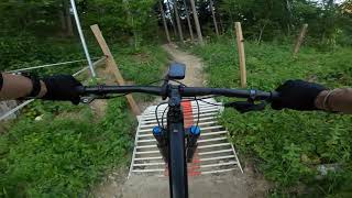
2:21 |
30 |
Sep 10, 2025
trail: Wissmeilenpass Oberstafel
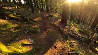
6:19 |
262 |
Apr 12, 2023 , Glarus Süd
trail: Widersteiner Bach Trail
7:33 |
232 |
Apr 12, 2023 , Glarus Süd
trail: KtGL, Achseli-Ewigs Wegli
7:34 |
389 |
Apr 12, 2023 , Glarus Süd

9:39 |
476 |
Jun 2, 2022 , Glarus
youtuber
![MTB Switzerland - Glarus Flow Trail...]()
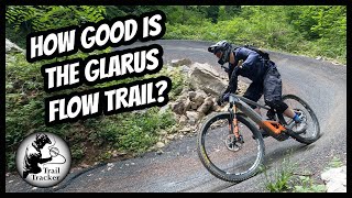
9:39 |
1121 |
Jun 2, 2022 , Glarus
13:11 |
2438 |
Sep 28, 2020 , Glarus
trail: Mollis1
13:09 |
1105 |
Sep 28, 2020 , Glarus Nord
Recent Trail Reports
Activity Feed
| username | action | type | title | date |
|---|---|---|---|---|
| DanielevZ8jVj | wishlist | route | activity #97239370 | Jun 18, 2026 @ 2:32am 1 day |
| MarcGlaus | ridden | trail | activity #96999633 | Jun 14, 2026 @ 1:16pm Jun 14, 2026 |
| RuedipfP3c7 | ridden | trail | activity #96322733 | Jun 5, 2026 @ 2:50pm Jun 5, 2026 |
| rufs | ridden | trail | activity #96108315 | Jun 2, 2026 @ 1:59pm Jun 2, 2026 |
| trailpapst | update | trail | activity #96088296 | Jun 2, 2026 @ 9:03am Jun 2, 2026 |
Recent Comments
| username | type | title | comment | date |
|---|---|---|---|---|
| trail | Very nice segment. Still snow-free on December... | Dec 23, 2025 @ 12:49pm Dec 23, 2025 | ||
| trail | Really fun, wide, blocky little trail. I would... | Nov 12, 2025 @ 8:42am Nov 12, 2025 | ||
| trail | Dr.Soubash try the Chli Kheist next time, you... | Oct 10, 2025 @ 9:08am Oct 10, 2025 | ||
| trail | you're just a machine... | Oct 4, 2025 @ 10:10am Oct 4, 2025 | ||
| trail | yep. the trail has almost no features exept... | Oct 4, 2025 @ 9:54am Oct 4, 2025 |
Local Badges
-

Descent 100k Badge1 awarded -

Epic Ride 50k154 awarded -

Big Ride 30k161 awarded -
Descent 100k Badge0 awarded -
Epic Ride 50k98 awarded -
Descent 100k Badge2 awarded
Bike & Skill Parks
| name | type | city | rating |
|---|---|---|---|
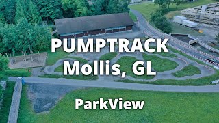
| Pumptrack Mollis | skill park | Glarus Nord | |
| Bike-Skillspark @Lintharena | skill park | Glarus Nord |
Activity Type Stats
| activitytype | trails | distance | descent | descent distance | total vertical | rating | global rank | state rank | photos | reports | routes | ridelogs |
|---|---|---|---|---|---|---|---|---|---|---|---|---|
| Mountain Bike | 137 | 57 miles | 49,012 ft | 49 miles | 6,398 ft | 98 | 402 | 7 | 6,133 | |||
| E-Bike | 118 | 41 miles | 35,620 ft | 35 miles | 6,398 ft | 5 | 311 | 3 | 1,225 | |||
| Hike | 132 | 53 miles | 46,362 ft | 45 miles | 6,398 ft | 352 | 1,157 | |||||
| Trail Running | 131 | 51 miles | 44,416 ft | 43 miles | 6,398 ft | 349 | 291 | |||||
| Snowshoe | 3 | 75 | ||||||||||
| Downhill Ski | 3 | 387 | ||||||||||
| Backcountry Ski | 3 | 762 | ||||||||||
| Nordic Ski | 3 | 96 |
Activities
Trails
Points of Interest
- By brenthillier
 NSMBA TRAILFORKS & contributors
 - Admins: swiss, trailpapst
- #8955 - 7,062 views
- glarus kanton activity log | embed map of Glarus Kanton mountain bike trails | glarus kanton mountain biking points of interest
Downloading of trail gps tracks in kml & gpx formats is enabled for Glarus Kanton.
You must login to download files.