close
-
Layers w
- Weather Layers
- Pro
- Pro
- Pro
- Pro
- Pro
- Pro
- More Layers
- Pro
- Pro
- Pro
- Pro
-
Upgrade to

3D
Trail Conditions
- Unknown
- Snow Groomed
- Snow Packed
- Snow Covered
- Snow Cover Partial
- Freeze/thaw Cycle
- Icy
- Prevalent Mud
- Wet
- Variable
- Ideal
- Dry
- Very Dry
Trail Flow (Ridden Direction)
Trailforks scans users ridelogs to determine the most popular direction each trail is ridden. A good flowing trail network will have most trails flowing in a single direction according to their intension.
The colour categories are based on what percentage of riders are riding a trail in its intended direction.
The colour categories are based on what percentage of riders are riding a trail in its intended direction.
- > 96%
- > 90%
- > 80%
- > 70%
- > 50%
- < 50%
- bi-directional trail
- no data
Trail Last Ridden
Trailforks scans ridelogs to determine the last time a trail was ridden.
- < 2 days
- < 1 week
- < 2 weeks
- < 1 month
- < 6 months
- > 6 months
Trail Ridden Direction
The intended direction a trail should be ridden.
- Downhill Only
- Downhill Primary
- Both Directions
- Uphill Primary
- Uphill Only
- One Direction
Contribute Details
Colors indicate trail is missing specified detail.
- Description
- Photos
- Description & Photos
- Videos
Trail Popularity ?
Trailforks scans ridelogs to determine which trails are ridden the most in the last 9 months.
Trails are compared with nearby trails in the same city region with a possible 25 colour shades.
Think of this as a heatmap, more rides = more kinetic energy = warmer colors.
- most popular
- popular
- less popular
- not popular
ATV/ORV/OHV Filter
Max Vehicle Width
inches
US Cell Coverage
Legend

Radar Time
Activity Recordings
Trailforks uses anonymized public activity data.
?
Activity Recordings
Trailforks uses anonymized public activity data.
?
Personal Heatmap
▶
Activity Types
all
/
none
▶
Options
2
Date range
month
–
Winter Trails
Warning
A routing network for winter maps does not exist. Selecting trails using the winter trails layer has been disabled.
Missing Trails
Most Popular
Least Popular
Trails are colored based on popularity. The more popular a trail is, the more red. Less popular trails trend towards green.
Jump Magnitude Heatmap
Heatmap of where riders jump on trails. Zoom in to see individual jumps, click circles to view jump details.
BC Backroad Status
![map legend]()
Service Road Atlas is a free to use, community-driven service for viewing and creating reports on the numerous back-country service roads around B.C. and Alberta.

Slope Aspect
Direction the slope faces
Trails Deemphasized
Trails are shown in grey.
Only show trails with no bike usage.
Suggested Layers
Based on selected activity type
Save the current map location and zoom level as your default home location whenever this page is loaded.
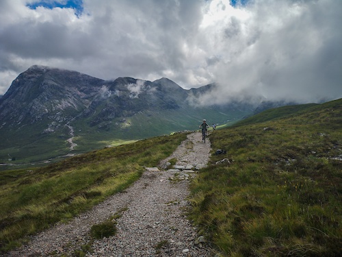
SaveFort William's 'Outdoor Capital of the UK' status begins at Cow Hill, a mere 15 minute stroll from the town centre. Depending on where you are on the circuit around the top of the hill, you'll have wide open views of Loch Eil, Loch Linnhe, Glen Nevis and its surrounding mountains. The northern end of the route also acts as a picturesque, road-free walk from Fort William directly into Glen Nevis.
As the name suggests, crofters used to graze their beasts on the slopes of Cow Hill. You might see some Highland cattle here now; the way they crop the grass is just right for some wildflowers and butterflies, so we’ve introduced a herd to help with our conservation work.
As the name suggests, crofters used to graze their beasts on the slopes of Cow Hill. You might see some Highland cattle here now; the way they crop the grass is just right for some wildflowers and butterflies, so we’ve introduced a herd to help with our conservation work.
Primary Trail Type: Cross-Country
Land Status: State Forest
Land Manager: Forestry And Land Scotland
 google parking directions
This region uses the Uk/Euro style trail grading system.
Activities Click to view
- Mountain Bike
18 trails
- E-Bike
18 trails
- Horse
12 trails
- Hike
18 trails
- Trail Running
18 trails
Region Details
- 10
- 1
- 2
- 5
Region Status
Caution as of Apr 3, 2026Stats
- Avg Trail Rating
- Trails (view details)
- 21
- Trails Mountain Bike
- 18
- Trails E-Bike
- 18
- Trails Adaptive Bike
- 1
- Trails Winter Fat Bike
- 1
- Trails Horse
- 12
- Trails Hike
- 18
- Trails Trail Running
- 18
- Total Distance
- 23 miles
- Total Descent Distance
- 7 miles
- Total Descent
- 3,198 ft
- Total Vertical
- 4,322 ft
- Highest Trailhead
- 4,373 ft
- Reports
- 49
- Photos
- 42
- Ridden Counter
- 1,499
Popular Glen Nevis Trails Mountain Biking Trails
• 95 ★ 5.0 • 3 miles • 624 ft • 148 • • hike
Popular red difficulty gravel path. This hike primary trail and has a moderate overall physical rating with a 624 ft blue climb. Trail visibility is always easy to follow. On average it takes 53 minutes to complete this trail.
• 95 ★ 4.0 • 1 mile • 6 ft • 64 •
Popular blue difficulty singletrack. This multi-use trail can be used both directions. It features berm and jump. Adaptive MTB rating: amtb black. On average it takes 6 minutes to complete this trail.
• 55 ★ 4.5 • 2,710 ft • 0 ft • 53 •
Moderately popular black difficulty singletrack. This multi-use trail can be used both directions and has a moderate overall physical rating with a 0 ft black diamond climb. Trail visibility is always easy to follow. On average it takes 6 minutes to complete this trail.
• 95 ★ 4.0 • 784 ft • 0 ft • 35 •
Popular black difficulty singletrack. This mountain bike primary trail. It features berm, drop and jump. On average it takes 1 minutes to complete this trail.
• 65 ★ 5.0 • 2,021 ft • 168 ft • 24 • • hike
This trail has a real sense of adventure and takes you to an exposed summit where you can still see the outline of a grassed-over fort, thought to have been built in the 7th century BC. The views of the glen and Ben Nevis from here are...
• 25 ★ 2.4 • 3 miles • 3,013 ft • 2 • • hike
This walking trail is not really ridable for the most part or recommended.
Photos of Glen Nevis Trails Mountain Bike
Recent Trail Reports
| status | trail | date | condition | info | user |
|---|---|---|---|---|---|
| Cow Hill Circuit | Apr 3, 2026 @ 9:18am (Europe/London) Apr 3, 2026 | Variable | KeironS LTA | ||
| Braveheart's Fury | Feb 1, 2026 @ 2:45pm (Europe/London) Feb 1, 2026 | Ideal | Stewartmac90 LTA | ||
| Hobo's | Dec 18, 2025 @ 10:43am (Europe/London) Dec 18, 2025 | Variable | albamountainbike LTA | ||
| Mel Gibsons Mess | Oct 6, 2025 @ 3:06pm (Europe/London) Oct 6, 2025 | Variable | albamountainbike LTA | ||
| West Highland Way (WHW-51) | Apr 28, 2025 @ 1:43pm Apr 28, 2025 | Wet | NickZhXfT9 | ||
| Access Road | Sep 22, 2024 @ 6:49am Sep 22, 2024 | Dry | Kjallen11 | ||
| Access Road | Oct 1, 2022 @ 9:31am Oct 1, 2022 | Wet | i5Os5o | ||
| The Peat Track | Oct 1, 2022 @ 9:29am Oct 1, 2022 | Wet | i5Os5o | ||
| Stob Ban | Jul 16, 2021 @ 2:35am Jul 16, 2021 | Variable | Beano68 | ||
| Access Road | Jun 25, 2021 @ 2:27am Jun 25, 2021 | Ideal | swalesdownhiller |
National Scenic Trails & Official Routes
-
West Highland Way
- Mountain Bike
- E-Bike
- Hike
- Trail Running
Activity Feed
| username | action | type | title | date |
|---|---|---|---|---|
| KeironS | add | report | activity #91805823 | Apr 3, 2026 @ 1:22am Apr 3, 2026 |
| KeironS | update | trail | activity #89219580 | Feb 20, 2026 @ 5:42am Feb 20, 2026 |
| RBRTSN | wishlist | trail | activity #89099637 | Feb 17, 2026 @ 4:14pm Feb 17, 2026 |
| AnnaT | add | report | activity #88288947 | Feb 3, 2026 @ 1:54pm Feb 3, 2026 |
| Stewartmac90 | add | report | activity #88155666 | Feb 1, 2026 @ 6:45am Feb 1, 2026 |
Recent Comments
| username | type | title | comment | date |
|---|---|---|---|---|
| trail | Not a trail, just a Forrest trail to a carpark | Jan 18, 2021 @ 10:43am Jan 18, 2021 |
Nearby Areas
| name | distance | ||||
|---|---|---|---|---|---|
| Fort William Trails | 2 | 1 | 2.2 km | ||
| Torlundy Trails | 1 | 3.3 km | |||
| Nevis Range Trails | 7 | 5.2 km | |||
| Inchree Trails | 6.5 km | ||||
| Strone Trails | 1 | 7 km |
Activity Type Stats
| activitytype | trails | distance | descent | descent distance | total vertical | rating | global rank | state rank | photos | reports | routes | ridelogs |
|---|---|---|---|---|---|---|---|---|---|---|---|---|
| Mountain Bike | 18 | 18 miles | 3,163 ft | 7 miles | 3,153 ft | #6,657 | #214 | 41 | 49 | 678 | ||
| E-Bike | 18 | 18 miles | 3,163 ft | 7 miles | 3,153 ft | #4,683 | #198 | 46 | 157 | |||
| Adaptive Bike | 1 | 1 mile | 472 ft | 1 mile | 466 ft | #6,989 | #336 | 8 | ||||
| Winter Fat Bike | 1 | 1 mile | 472 ft | 1 mile | 466 ft | #6,974 | #335 | 2 | ||||
| Horse | 12 | 13 miles | 1,923 ft | 6 miles | 866 ft | #1,911 | #93 | 11 | ||||
| Hike | 18 | 22 miles | 2,467 ft | 7 miles | 4,321 ft | #6,196 | #130 | 1 | 33 | 280 | ||
| Trail Running | 18 | 22 miles | 2,467 ft | 7 miles | 4,321 ft | #6,000 | #136 | 35 | 363 |
Frequently Asked Questions About Glen Nevis Trails
▼
What are the highest rated mountain biking trails in Glen Nevis Trails?
The highest rated mountain biking trails in Glen Nevis Trails are:
- West Highland Way (WHW-51) (4.1/5)
- Dun Deardail Path (4.1/5)
- Braveheart's Fury (4.1/5)
- The Peat Track (4.1/5)
- Cow Hill Circuit (4/5)
▼
What is the best time of the year to ride in Glen Nevis Trails?
Based on ride log data, the most popular months to ride in Glen Nevis Trails are:
- May (6 activities)
- June (3 activities)
- July (3 activities)
▼
Where can I park to ride in Glen Nevis Trails?
There are 3 parking locations listed in Glen Nevis Trails. The most popular parking spots are: View all parking and trailhead locations on the map to plan your visit.
▼
What is the longest trail in Glen Nevis Trails?
The longest trail in Glen Nevis Trails is Stob Ban at 5.1 km. View all trails sorted by distance.
Activities
Trails
Points of Interest
- By gav-s
 & contributors
 - Admins: LTA, LTA, LTA
- #42265 - 4,222 views
- glen nevis trails activity log | embed map of Glen Nevis Trails mountain bike trails | glen nevis trails mountain biking points of interest
Downloading of trail gps tracks in kml & gpx formats is enabled for Glen Nevis Trails.
You must login to download files.