close
-
Layers w
- Weather Layers
- Pro
- Pro
- Pro
- Pro
- Pro
- Pro
- More Layers
- Pro
- Pro
- Pro
- Pro
-
Upgrade to

3D
Trail Conditions
- Unknown
- Snow Groomed
- Snow Packed
- Snow Covered
- Snow Cover Partial
- Freeze/thaw Cycle
- Icy
- Prevalent Mud
- Wet
- Variable
- Ideal
- Dry
- Very Dry
Trail Flow (Ridden Direction)
Trailforks scans users ridelogs to determine the most popular direction each trail is ridden. A good flowing trail network will have most trails flowing in a single direction according to their intension.
The colour categories are based on what percentage of riders are riding a trail in its intended direction.
The colour categories are based on what percentage of riders are riding a trail in its intended direction.
- > 96%
- > 90%
- > 80%
- > 70%
- > 50%
- < 50%
- bi-directional trail
- no data
Trail Last Ridden
Trailforks scans ridelogs to determine the last time a trail was ridden.
- < 2 days
- < 1 week
- < 2 weeks
- < 1 month
- < 6 months
- > 6 months
Trail Ridden Direction
The intended direction a trail should be ridden.
- Downhill Only
- Downhill Primary
- Both Directions
- Uphill Primary
- Uphill Only
- One Direction
Contribute Details
Colors indicate trail is missing specified detail.
- Description
- Photos
- Description & Photos
- Videos
Trail Popularity ?
Trailforks scans ridelogs to determine which trails are ridden the most in the last 9 months.
Trails are compared with nearby trails in the same city region with a possible 25 colour shades.
Think of this as a heatmap, more rides = more kinetic energy = warmer colors.
- most popular
- popular
- less popular
- not popular
ATV/ORV/OHV Filter
Max Vehicle Width
inches
US Cell Coverage
Legend

Radar Time
Activity Recordings
Trailforks uses anonymized public activity data.
?
Activity Recordings
Trailforks uses anonymized public activity data.
?
Personal Heatmap
▶
Activity Types
all
/
none
▶
Options
2
Date range
month
–
Winter Trails
Warning
A routing network for winter maps does not exist. Selecting trails using the winter trails layer has been disabled.
Missing Trails
Most Popular
Least Popular
Trails are colored based on popularity. The more popular a trail is, the more red. Less popular trails trend towards green.
Jump Magnitude Heatmap
Heatmap of where riders jump on trails. Zoom in to see individual jumps, click circles to view jump details.
BC Backroad Status
![map legend]()
Service Road Atlas is a free to use, community-driven service for viewing and creating reports on the numerous back-country service roads around B.C. and Alberta.

Slope Aspect
Direction the slope faces
Trails Deemphasized
Trails are shown in grey.
Only show trails with no bike usage.
Suggested Layers
Based on selected activity type
Save the current map location and zoom level as your default home location whenever this page is loaded.
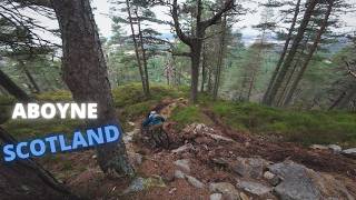
SaveGlen Tanar is a superb area for many outdoor sports and recreation types. There are several superb enduro trails locally as well as great opportunities for gravel and general XC riding.
Glen Tanar is a National Nature Reserve, part of the Cairngorms National Park and has sites of Special Scientific Interest (SSSI) so please be respectful of signage from the Glen Tanar Ranger service and Glen Tanar Estate as they try to protect rare local species such as Capercaillie, Goshawks, Peregrine Falcons, Merlin etc etc.
Aberdeenshire Trail Association (ATA) maintains local trails so please consider a donation You can donate on Pinkbike or via the local bike shop Firetrail in Aboyne.
Primary Trail Type: Cross-Country
Land Status: National Park
Land Manager: Glen Tanar Estate
 google parking directions
Links
This region uses the Uk/Euro style trail grading system.
Activities Click to view
- Mountain Bike
42 trails
- E-Bike
42 trails
- Horse
8 trails
- Hike
32 trails
- Trail Running
32 trails
Region Details
- 25
- 1
- 5
- 5
- 2
- 1
Region Status
Open as of Jun 12, 2026Stats
- Avg Trail Rating
- Trails (view details)
- 39
- Trails Mountain Bike
- 42
- Trails E-Bike
- 42
- Trails Horse
- 8
- Trails Hike
- 32
- Trails Trail Running
- 32
- Total Distance
- 60 miles
- Total Descent
- 14,061 ft
- Total Vertical
- 1,896 ft
- Highest Trailhead
- 2,384 ft
- Reports
- 362
- Photos
- 79
- Ridden Counter
- 5,480
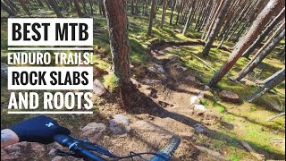
Popular Glen Tanar Mountain Biking Trails
• 100 ★ 4.7 • 1,388 ft • 72 ft • 695 •
Highly rated popular blue difficulty singletrack. This multi-use trail can be used uphill primary and has a hard overall physical rating with a 72 ft blue climb. On average it takes 3 minutes to complete this trail.
• 90 ★ 4.4 • 1 mile • 0 ft • 687 •
From the mast to the road, long decent with some good flow. Pedaly section about halfway down but a properly good trail. Turn left at the forestry road crossing, next section should be obvious.
• 90 ★ 4.4 • 2,415 ft • 0 ft • 360 •
Trail has been re opened by someone, it has slightly changed in the top section and a bit of a new line in the middle part. and a new ending which goes right instead off going into the old tip. but it is good to have it opened but it...
• 90 ★ 4.5 • 2,365 ft • 0 ft • 294 •
is a steep, loamy trail with switchbacks that make you smile. A definite ride for any one who is finishing their day - an absolute banger. Currently has some difficult log drops at the top due to windfall trees. Be careful.
• 90 ★ 5.0 • 2,520 ft • 0 ft • 225 •
very technical trail, with loads of steep shoots and rock drops, roots and some off camber sections. enough to keep you awake
• 85 ★ 5.0 • 1,450 ft • 0 ft • 211 •
Descend the start of and before the big rock drop head right. Gather speed for the ‘Half Pipe Bomb Hole’ and a sharp left hand turn straight after - hit this fast and you fly out towards the trees. Next up is an optional rock...
Dark Magic Permanently Closed
• 70 ★ 5.0 • 856 ft • 0 ft • 208 •
Popular red difficulty closed singletrack. This mountain bike primary trail can be used downhill primary. On average it takes 3 minutes to complete this trail.
• 85 ★ 4.0 • 1,512 ft • 0 ft • 191 •
easy red, with some stone roller features. then into a couple of slabs, on has a easier line to side, nice warm up trail that drops you 3/4 the way up the fire road
Photos of Glen Tanar Mountain Bike
Videos of Glen Tanar Mountain Bike
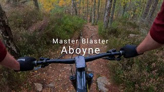
trail: Master Blaster
136 |
Oct 17, 2025 , Aboyne

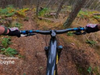
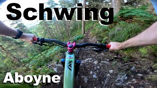
trail: Schwing
3:29 |
73 |
Jul 31, 2025 , Aboyne
trail: Schwing
13:12 |
72 |
Mar 25, 2025 , Aboyne

trail: Master Blaster
13:12 |
150 |
Mar 25, 2025 , Aboyne

trail: Friends Electric
13:12 |
152 |
Mar 25, 2025 , Aboyne
youtuber
![Best enduro trails! Aboyne MTB Trails:...]()
trail: Master Blaster
13:33 |
257 |
Nov 1, 2024 , Aboyne
trail: Emasculation
253 |
Oct 23, 2024 , Aboyne
trail: Schwing
6:49 |
112 |
Aug 6, 2024 , Aboyne
Recent Trail Reports
| status | trail | date | condition | info | user |
|---|---|---|---|---|---|
| Emasculation | Jun 12, 2026 @ 11:56am (Europe/London) Jun 12, 2026 | Ideal | turnertower | ||
| Master Blaster | May 27, 2026 @ 6:14pm (Europe/London) May 27, 2026 | Ideal | trailmax69 | ||
| Schwing | May 27, 2026 @ 6:14pm (Europe/London) May 27, 2026 | Ideal | trailmax69 | ||
| Craigendinnie Conquest | May 27, 2026 @ 6:14pm (Europe/London) May 27, 2026 | Ideal | trailmax69 | ||
| Reaper | Apr 16, 2026 @ 2:33pm (Europe/London) Apr 16, 2026 | Variable | Shackleton | ||
| Dark Magic | Apr 10, 2026 @ 5:18pm (Europe/London) Apr 10, 2026 | Ideal | trailmax69 | ||
| Zapper | Apr 10, 2026 @ 5:18pm (Europe/London) Apr 10, 2026 | Very Dry | trailmax69 | ||
| Friends Electric | Apr 10, 2026 @ 5:18pm (Europe/London) Apr 10, 2026 | Very Dry | trailmax69 | ||
| Between the Bridges North | Oct 16, 2025 @ 12:07pm (Europe/London) Oct 16, 2025 | Ideal | londondl | ||
| Dudes with Boobs | Apr 8, 2025 @ 3:56am Apr 8, 2025 | Very Dry | aly-14 |
Activity Feed
| username | action | type | title | date |
|---|---|---|---|---|
| turnertower | add | report | activity #96793063 | Jun 12, 2026 @ 3:56am Jun 12, 2026 |
| jpeligrod | wishlist | trail | activity #96234316 | Jun 4, 2026 @ 9:38am Jun 4, 2026 |
| Kulas1985 | wishlist | trail | activity #96213480 | Jun 4, 2026 @ 3:06am Jun 4, 2026 |
| trailmax69 | add | report | activity #95692518 and 2 more | May 28, 2026 @ 1:45am May 28, 2026 |
| jpeligrod | wishlist | trail | activity #95368140 and 1 more | May 23, 2026 @ 5:23pm May 23, 2026 |
Recent Comments
| username | type | title | comment | date |
|---|---|---|---|---|
| trail | Amazing gnarly, full commitment trial. Very... | Apr 7, 2026 @ 3:49am Apr 7, 2026 | ||
| trail | Was to steep for me could probably ride it if... | Jul 9, 2025 @ 1:10pm Jul 9, 2025 | ||
| report | Misf | Jun 20, 2023 @ 3:15am Jun 20, 2023 | ||
| trail | Great trail really enjoyed it. Had to stop and... | May 27, 2023 @ 8:23am May 27, 2023 | ||
| trail | First time riding it since the storms. An... | May 12, 2023 @ 12:10pm May 12, 2023 |
Nearby Areas
| name | distance | ||||
|---|---|---|---|---|---|
| Court Hill | 1.9 km | ||||
| Balfour Forest | 3 | 26 | 2.3 km | ||
| Tarland Trails - Drummy Woods | 1 | 4.6 km | |||
| Tarland Trails - Pittenderich | 10 | 9 | 5.3 km | ||
| Potarch | 1 | 6 km |
Local Badges
-

Completionist0 awarded
Activity Type Stats
| activitytype | trails | distance | descent | descent distance | total vertical | rating | global rank | state rank | photos | reports | routes | ridelogs |
|---|---|---|---|---|---|---|---|---|---|---|---|---|
| Mountain Bike | 42 | 60 miles | 14,062 ft | 34 miles | 1,896 ft | #2,382 | #75 | 73 | 362 | 1,855 | ||
| E-Bike | 42 | 60 miles | 14,062 ft | 34 miles | 1,896 ft | #2,270 | #82 | 6 | 335 | 317 | ||
| Horse | 8 | 4 miles | 299 ft | 1 mile | 719 ft | #2,210 | #107 | 40 | ||||
| Hike | 32 | 57 miles | 11,335 ft | 30 miles | 1,896 ft | #4,038 | #68 | 256 | 91 | |||
| Trail Running | 32 | 57 miles | 11,335 ft | 30 miles | 1,896 ft | #3,254 | #62 | 256 | 289 |
Frequently Asked Questions About Glen Tanar
▼
What are the highest rated mountain biking trails in Glen Tanar?
The highest rated mountain biking trails in Glen Tanar are:
- Schwing (4.5/5)
- Craigendinnie Conquest (4.3/5)
- Reaper (4.3/5)
- Emasculation (4.3/5)
- Master Blaster (4.3/5)
▼
What is the best time of the year to ride in Glen Tanar?
Based on ride log data, the most popular months to ride in Glen Tanar are:
- July (10 activities)
- September (6 activities)
- March (6 activities)
▼
Where can I park to ride in Glen Tanar?
There are 1 parking locations listed in Glen Tanar. The most popular parking spots are:
▼
What is the longest trail in Glen Tanar?
The longest trail in Glen Tanar is Decent Descent at 2.3 miles. View all trails sorted by distance.
Activities
- By gav-s
 & contributors
 - Admins: ATA, NEAT, ATA
- #46626 - 6,084 views
- glen tanar activity log | embed map of Glen Tanar mountain bike trails | glen tanar mountain biking points of interest
Downloading of trail gps tracks in kml & gpx formats is enabled for Glen Tanar.
You must login to download files.