close
-
Layers w
- Weather Layers
- Pro
- Pro
- Pro
- Pro
- Pro
- Pro
- More Layers
- Pro
- Pro
- Pro
- Pro
-
Upgrade to

3D
Trail Conditions
- Unknown
- Snow Groomed
- Snow Packed
- Snow Covered
- Snow Cover Partial
- Freeze/thaw Cycle
- Icy
- Prevalent Mud
- Wet
- Variable
- Ideal
- Dry
- Very Dry
Trail Flow (Ridden Direction)
Trailforks scans users ridelogs to determine the most popular direction each trail is ridden. A good flowing trail network will have most trails flowing in a single direction according to their intension.
The colour categories are based on what percentage of riders are riding a trail in its intended direction.
The colour categories are based on what percentage of riders are riding a trail in its intended direction.
- > 96%
- > 90%
- > 80%
- > 70%
- > 50%
- < 50%
- bi-directional trail
- no data
Trail Last Ridden
Trailforks scans ridelogs to determine the last time a trail was ridden.
- < 2 days
- < 1 week
- < 2 weeks
- < 1 month
- < 6 months
- > 6 months
Trail Ridden Direction
The intended direction a trail should be ridden.
- Downhill Only
- Downhill Primary
- Both Directions
- Uphill Primary
- Uphill Only
- One Direction
Contribute Details
Colors indicate trail is missing specified detail.
- Description
- Photos
- Description & Photos
- Videos
Trail Popularity ?
Trailforks scans ridelogs to determine which trails are ridden the most in the last 9 months.
Trails are compared with nearby trails in the same city region with a possible 25 colour shades.
Think of this as a heatmap, more rides = more kinetic energy = warmer colors.
- most popular
- popular
- less popular
- not popular
ATV/ORV/OHV Filter
Max Vehicle Width
inches
US Cell Coverage
Legend

Radar Time
Activity Recordings
Trailforks uses anonymized public activity data.
?
Activity Recordings
Trailforks uses anonymized public activity data.
?
Personal Heatmap
▶
Activity Types
all
/
none
▶
Options
2
Date range
month
–
Winter Trails
Warning
A routing network for winter maps does not exist. Selecting trails using the winter trails layer has been disabled.
Missing Trails
Most Popular
Least Popular
Trails are colored based on popularity. The more popular a trail is, the more red. Less popular trails trend towards green.
Jump Magnitude Heatmap
Heatmap of where riders jump on trails. Zoom in to see individual jumps, click circles to view jump details.
BC Backroad Status
![map legend]()
Service Road Atlas is a free to use, community-driven service for viewing and creating reports on the numerous back-country service roads around B.C. and Alberta.

Slope Aspect
Direction the slope faces
Trails Deemphasized
Trails are shown in grey.
Only show trails with no bike usage.
Suggested Layers
Based on selected activity type
Save the current map location and zoom level as your default home location whenever this page is loaded.
Save
No description for Glenbrook has been added yet!
Login or register to submit one.
Activities Click to view
- Mountain Bike
34 trails
- E-Bike
18 trails
- Gravel Bike
0 trails
- Adaptive Bike
- Winter Fat Bike
0 trails
- Hike
39 trails
- Trail Running
39 trails
Region Details
- 2
- 2
- 10
- 14
- 4
Region Status
Open as of Jun 20, 2026Stats
- Avg Trail Rating
- Trails (view details)
- 40
- Trails Mountain Bike
- 34
- Trails E-Bike
- 18
- Trails Horse
- 2
- Trails Hike
- 39
- Trails Trail Running
- 39
- Total Distance
- 38 miles
- Total Descent
- 7,120 ft
- Total Vertical
- 878 ft
- Highest Trailhead
- 996 ft
- Reports
- 325
- Photos
- 313
- Ridden Counter
- 2,697
Sub Regions
-
Glenbrook Trails
- 1
- 6
- 6
-
Knapsack Reserve Trails
- 1
- 3
- 8
- 4
Popular Glenbrook Mountain Biking Trails
• 100 ★ 4.7 • 5 miles • 43 ft • 990 •
This track is awesome fun. You finish the oaks fire trail and go into a nice flowing single track, at the start it is very natural but ends up turning into man made jumps and berms.
• 95 ★ 5.0 • 1,450 ft • 23 ft • 470 •
Popular green difficulty singletrack. This mountain bike primary trail can be used both directions. On average it takes 1 minutes to complete this trail.
• 85 ★ 0.0 • 2,030 ft • 23 ft • 286 •
Highway avoidance between Knapsack and Glenbrook RAAF base.
• 40 ★ 2.3 • 4 miles • 471 ft • 234 •
Moderately popular blue difficulty singletrack. This mountain bike primary trail can be used both directions and has a moderate overall physical rating with a 471 ft green climb. Trail visibility is sometimes hard to follow. On average it takes 38 minutes to complete this trail.
• 45 ★ 4.0 • 1,801 ft • 3 ft • 230 •
Moderately popular black diamond difficulty singletrack. This mountain bike primary trail can be used uphill primary and has a hard overall physical rating with a 3 ft double black diamond climb. On average it takes 4 minutes to complete this trail.
• 95 ★ 0.0 • 1,010 ft • 5 ft • 229 •
Popular blue difficulty singletrack. This mountain bike primary trail can be used downhill primary. Trail visibility is always easy to follow. On average it takes 2 minutes to complete this trail.
• 90 ★ 4.0 • 3 miles • 17 ft • 208 •
Fire Trail down to the Euroka Camp Ground
Glenbrook Mountain Bike Routes
★ 5.0 • 4 miles • 412 ft • 0 • Loop •
A full "signposted" lap of Knapsack reserve. Lovers walk start/finish
• 23 miles • 2,460 ft • 5 •
• 9 miles • 1,148 ft • 4 •
• 1 mile • 168 ft • 1 •
• 9 miles • 3,408 ft • 0 •
• 9 miles • 832 ft • 1 •
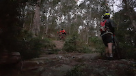
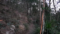
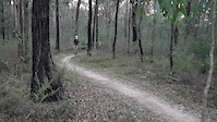
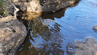
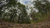
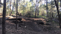
Photos of Glenbrook Mountain Bike
Videos of Glenbrook Mountain Bike

trail: The Oaks Single Track
0:08 |
126 |
Aug 6, 2023
trail: Euroka Link
0:19 |
19 |
Aug 5, 2023
trail: Euroka Link
0:25 |
11 |
Aug 5, 2023
trail: Euroka Link
0:22 |
10 |
Aug 5, 2023

trail: Duck Hole Walking Track
0:32 |
10 |
Apr 14, 2023
trail: St.Helena Walking Track
0:26 |
9 |
Apr 14, 2023
trail: Knapsack XC1
0:22 |
151 |
Dec 17, 2022
trail: Knapsack XC1
0:09 |
|
Feb 3, 2022
Recent Trail Reports
| status | trail | date | condition | info | user |
|---|---|---|---|---|---|
| Glenbrook Creek Climb | Jun 21, 2026 @ 10:17am (Australia/Sydney) Jun 20, 2026 | Ideal | MacroTiara | ||
| Bennets Ridge Fire Trail | Jun 21, 2026 @ 7:57am (Australia/Sydney) Jun 20, 2026 | Ideal | MacroTiara | ||
| Leonay Trail | May 16, 2026 @ 8:19am (Australia/Sydney) May 15, 2026 | Ideal | MacroTiara | ||
| Tunnel Run | May 16, 2026 @ 8:19am (Australia/Sydney) May 15, 2026 | Ideal | MacroTiara | ||
| String Line | May 16, 2026 @ 8:19am (Australia/Sydney) May 15, 2026 | Ideal | MacroTiara | ||
| Poisonous Monkey | Feb 13, 2026 @ 8:54am (Australia/Sydney) Feb 12, 2026 | Ideal | MacroTiara | ||
| Wayne's World | Feb 13, 2026 @ 8:54am (Australia/Sydney) Feb 12, 2026 | Ideal | MacroTiara | ||
| The Oaks Single Track | Feb 13, 2026 @ 10:24am (Australia/Sydney) Feb 12, 2026 | Ideal | MacroTiara | ||
| Zig Zag Enduro | Feb 11, 2026 @ 6:14am (Australia/Sydney) Feb 10, 2026 | Ideal | zokstar | ||
| Nepean Lookout | Aug 17, 2025 @ 2:36pm Aug 17, 2025 | Ideal | RomanMark |
Activity Feed
| username | action | type | title | date |
|---|---|---|---|---|
| MacroTiara | add | report | activity #97451149 and 1 more | Jun 20, 2026 @ 7:38pm Jun 20, 2026 |
| annekagoss | wishlist | trail | activity #96961642 | Jun 14, 2026 @ 6:24am Jun 14, 2026 |
| Leviab | ridden | trail | activity #96508450 | Jun 7, 2026 @ 4:57pm Jun 7, 2026 |
| MrSimple87 | ridden | trail | activity #96336320 | Jun 5, 2026 @ 6:46pm Jun 5, 2026 |
| annekagoss | wishlist | trail | activity #96005235 | Jun 1, 2026 @ 2:34am Jun 1, 2026 |
Recent Comments
| username | type | title | comment | date |
|---|---|---|---|---|
| trail | I was hoping that signage might have improved... | Apr 11, 2026 @ 6:18pm Apr 11, 2026 | ||
| trail | Dry rocky, dangerous, untamed, absolutely no... | Oct 2, 2025 @ 2:21am Oct 2, 2025 | ||
| trail | If this is blue rated, then I maybe I’m... | Jun 4, 2025 @ 8:38pm Jun 4, 2025 | ||
| trail | great views | Dec 16, 2024 @ 2:19pm Dec 16, 2024 | ||
| trail | NPWS continue to turn this trail into a 50m... | Oct 4, 2024 @ 2:31am Oct 4, 2024 |
Local Badges
-

10 Blue Trails6 awarded -

Epic Mountain Bike Climb 2k0 awarded -

Climbing 10k Badge2 awarded -

Mountain Biking 100k Badge0 awarded -

Epic Ride Descent 2k0 awarded -

Descent 10k Badge2 awarded
Activity Type Stats
| activitytype | trails | distance | descent | descent distance | total vertical | rating | global rank | state rank | photos | reports | routes | ridelogs |
|---|---|---|---|---|---|---|---|---|---|---|---|---|
| Mountain Bike | 34 | 32 miles | 5,266 ft | 18 miles | 879 ft | #2,443 | #114 | 313 | 325 | 1 | 12,424 | |
| E-Bike | 18 | 24 miles | 3,465 ft | 14 miles | 761 ft | #4,132 | #194 | 274 | 1,755 | |||
| Horse | 2 | 2 miles | 197 ft | 1,919 ft | 440 ft | 34 | ||||||
| Hike | 39 | 37 miles | 6,375 ft | 21 miles | 879 ft | #5,217 | #164 | 300 | 399 | |||
| Trail Running | 39 | 37 miles | 6,375 ft | 21 miles | 879 ft | #4,625 | #147 | 300 | 1,410 |
Frequently Asked Questions About Glenbrook
▼
What are the best places to ride in Glenbrook?
Glenbrook has 2 areas to explore for mountain biking. The top rated areas are:
▼
What are the highest rated mountain biking trails in Glenbrook?
The highest rated mountain biking trails in Glenbrook are:
- The Oaks Single Track (4.4/5)
- La-goon (4.1/5)
- Wayne's World (4.1/5)
- Nepean Lookout (4.1/5)
- Mount Portal (4.1/5)
▼
What is the best time of the year to ride in Glenbrook?
Based on ride log data, the most popular months to ride in Glenbrook are:
- August (44 activities)
- July (42 activities)
- October (38 activities)
▼
Where can I park to ride in Glenbrook?
There are 6 parking locations listed in Glenbrook. The most popular parking spots are: View all parking and trailhead locations on the map to plan your visit.
Activities
Trails
- By WillieJacobsz
 Trailforks SBP SWW & contributors
 - Admins: stuartrichardson, RBM
- #58415 - 1,941 views
- glenbrook activity log | embed map of Glenbrook mountain bike trails | glenbrook mountain biking points of interest
Downloading of trail gps tracks in kml & gpx formats is enabled for Glenbrook.
You must login to download files.