close
-
Layers w
- Weather Layers
- Pro
- Pro
- Pro
- Pro
- Pro
- Pro
- More Layers
- Pro
- Pro
- Pro
- Pro
-
Upgrade to

3D
Trail Conditions
- Unknown
- Snow Groomed
- Snow Packed
- Snow Covered
- Snow Cover Partial
- Freeze/thaw Cycle
- Icy
- Prevalent Mud
- Wet
- Variable
- Ideal
- Dry
- Very Dry
Trail Flow (Ridden Direction)
Trailforks scans users ridelogs to determine the most popular direction each trail is ridden. A good flowing trail network will have most trails flowing in a single direction according to their intension.
The colour categories are based on what percentage of riders are riding a trail in its intended direction.
The colour categories are based on what percentage of riders are riding a trail in its intended direction.
- > 96%
- > 90%
- > 80%
- > 70%
- > 50%
- < 50%
- bi-directional trail
- no data
Trail Last Ridden
Trailforks scans ridelogs to determine the last time a trail was ridden.
- < 2 days
- < 1 week
- < 2 weeks
- < 1 month
- < 6 months
- > 6 months
Trail Ridden Direction
The intended direction a trail should be ridden.
- Downhill Only
- Downhill Primary
- Both Directions
- Uphill Primary
- Uphill Only
- One Direction
Contribute Details
Colors indicate trail is missing specified detail.
- Description
- Photos
- Description & Photos
- Videos
Trail Popularity ?
Trailforks scans ridelogs to determine which trails are ridden the most in the last 9 months.
Trails are compared with nearby trails in the same city region with a possible 25 colour shades.
Think of this as a heatmap, more rides = more kinetic energy = warmer colors.
- most popular
- popular
- less popular
- not popular
ATV/ORV/OHV Filter
Max Vehicle Width
inches
US Cell Coverage
Legend

Radar Time
Activity Recordings
Trailforks uses anonymized public activity data.
?
Activity Recordings
Trailforks uses anonymized public activity data.
?
Personal Heatmap
▶
Activity Types
all
/
none
▶
Options
2
Date range
month
–
Winter Trails
Warning
A routing network for winter maps does not exist. Selecting trails using the winter trails layer has been disabled.
Missing Trails
Most Popular
Least Popular
Trails are colored based on popularity. The more popular a trail is, the more red. Less popular trails trend towards green.
Jump Magnitude Heatmap
Heatmap of where riders jump on trails. Zoom in to see individual jumps, click circles to view jump details.
BC Backroad Status
![map legend]()
Service Road Atlas is a free to use, community-driven service for viewing and creating reports on the numerous back-country service roads around B.C. and Alberta.

Slope Aspect
Direction the slope faces
Trails Deemphasized
Trails are shown in grey.
Only show trails with no bike usage.
Suggested Layers
Based on selected activity type
Save the current map location and zoom level as your default home location whenever this page is loaded.
Save
No description for Glendora has been added yet!
Login or register to submit one.
Activities Click to view
- Mountain Bike
23 trails
- Adaptive Bike
0 trails
- Horse
10 trails
- Hike
32 trails
- Trail Running
31 trails
Region Details
- 5
- 6
- 7
- 1
Region Status
Caution as of Jun 7, 2026Stats
- Avg Trail Rating
- Trails (view details)
- 27
- Trails Mountain Bike
- 23
- Trails E-Bike
- 2
- Trails Horse
- 10
- Trails Hike
- 32
- Trails Trail Running
- 31
- Total Distance
- 33 miles
- Total Descent Distance
- 15 miles
- Total Descent
- 7,249 ft
- Total Vertical
- 7,647 ft
- Highest Trailhead
- 8,411 ft
- Reports
- 28
- Photos
- 62
- Ridden Counter
- 942
Sub Regions
-
Crystal Lake
- 4
-
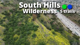
South Hills Wilderness Area
- 5
- 2
Popular Glendora Mountain Biking Trails
• 95 ★ 0.0 • 2,753 ft • 14 ft • 22 •
Popular green difficulty doubletrack. This multi-use trail can be used both directions. On average it takes 4 minutes to complete this trail.
• 90 ★ 0.0 • 1,768 ft • 223 ft • 18 •
The trail goes on an uphill climb that heads north to the junction with the South Hills Trail. Portions of this trail offer shade. The lower portion passes through naturalized weedy areas with previously planted trees such as...
• 85 ★ 0.0 • 1,818 ft • 12 ft • 18 •
Popular blue difficulty singletrack. This multi-use trail can be used both directions and has a moderate overall physical rating. Trail visibility is always easy to follow. On average it takes 1 minutes to complete this trail.
• 50 ★ 0.0 • 2 miles • 377 ft • 14 •
This 20-foot-wide path going from east to west is the ridge of the South Hills Wilderness Area. This trail offers 360 degree views of the city. Hill tops glisten as the cactus reflect sunlight. Almost all trails end at South Hills, so...
• 100 ★ 0.0 • 1,345 ft • 124 ft • 12 •
Popular green difficulty singletrack. This multi-use trail can be used both directions. On average it takes 1 minutes to complete this trail.
• 80 ★ 0.0 • 1,683 ft • 12 ft • 11 •
Popular green difficulty doubletrack. This multi-use trail can be used both directions. On average it takes 2 minutes to complete this trail.
• 60 ★ 5.0 • 5 miles • 29 ft • 10 •
The connects the summit of with the Crystal Lake trailhead. The trail starts about 0.5km below the summit, at a junction with the Trail. A rough traverse across open slopes leads to the crest of . A long rocky section follows the ridge...
• 75 ★ 4.0 • 3 miles • 1,887 ft • 6 • • hike
The leads from the Crystal Lake trailhead to , where it connects with the Pacific Crest Trail (closed to bikes) and the Mount Islip Trail. Along the way, the trail crosses the Deer Flat Road and the , and intersects with the . The grade...
Glendora Mountain Bike Routes
★ 5.0 • 11 miles • 2,711 ft • 0 • Loop •
Crystal Lake High Alpine Loop #1 is a typical loop option for riding the from Crystal Lake CG. This is one...
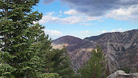
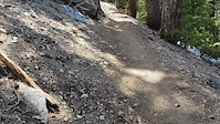
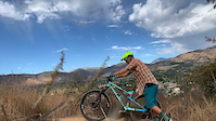
Photos of Glendora Mountain Bike
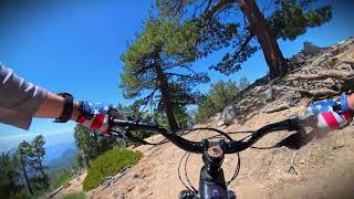
Videos of Glendora Mountain Bike
trail: Mount Islip Trail
0:20 |
24 |
Oct 9, 2022
trail: Mount Islip Trail
2:24 |
22 |
Jul 7, 2022
trail: South Hills Backbone Trail
0:16 |
224 |
Nov 3, 2019
trail: Islip Ridge Trail
33:21 |
10 |
Jun 8, 2026 , Glendora

trail: Islip Ridge Trail
36:44 |
33 |
Oct 28, 2025 , Glendora

trail: South Hills Backbone Trail
10:13 |
63 |
Apr 16, 2025 , Glendora
trail: East View South Fork Trail
10:13 |
51 |
Apr 16, 2025 , Glendora

trail: North Spur Trail
10:13 |
46 |
Apr 16, 2025 , Glendora
Recent Trail Reports
| status | trail | date | condition | info | user |
|---|---|---|---|---|---|
| Islip Ridge Trail | Jun 7, 2026 @ 7:58pm (America/Los_Angeles) Jun 7, 2026 | Ideal | Singltrkr1 | ||
| Punk Out Trail | Dec 30, 2024 @ 10:25pm Dec 30, 2024 | Very Dry | cyberdemyn | ||
| Mount Islip Trail | May 19, 2024 @ 10:12pm May 19, 2024 | Snow Cover Partial | thomasjkenney1024 | ||
| Poop Out Trail | Oct 27, 2023 @ 7:14pm Oct 27, 2023 | Dry | HotCheeto24 | ||
| Alosta Canyon Trail | May 29, 2023 @ 10:31pm May 29, 2023 | Dry | dgonser1 | ||
| Windy Gap Trail | Oct 30, 2022 @ 9:52am Oct 30, 2022 | Dry | don-sean |
Activity Feed
| username | action | type | title | date |
|---|---|---|---|---|
| Singltrkr1 | add | video | activity #96560162 | Jun 8, 2026 @ 1:13pm Jun 8, 2026 |
| Singltrkr1 | add | report | activity #96517506 | Jun 7, 2026 @ 7:58pm Jun 7, 2026 |
| nateboarding | wishlist | route | activity #96258109 | Jun 4, 2026 @ 4:08pm Jun 4, 2026 |
| ctramonte | wishlist | trail | activity #85001784 | Nov 30, 2025 @ 9:38pm Nov 30, 2025 |
| smutpeddler | ridden | trail | activity #84078494 and 1 more | Nov 13, 2025 @ 10:03am Nov 13, 2025 |
Recent Comments
| username | type | title | comment | date |
|---|---|---|---|---|
| trail | more like double red diamond. Geez, loved that... | Sep 20, 2025 @ 2:31pm Sep 20, 2025 | ||
| trail | rode this trail in March . its unrideable over... | Sep 10, 2025 @ 9:51am Sep 10, 2025 | ||
| trail | trail is unradible | Sep 10, 2025 @ 9:18am Sep 10, 2025 | ||
| trail | super fun trail. the approach up the closed... | Jul 21, 2025 @ 3:53pm Jul 21, 2025 | ||
| trail | I rode here for the first time in 10+ years. ... | Jun 24, 2025 @ 3:30pm Jun 24, 2025 |
Local Badges
-

Epic Mountain Bike Climb 2k219 awarded -

Climbing 10k Badge31 awarded -

Mountain Biking 100k Badge1 awarded -

Big Ride 30k743 awarded -

Epic Ride 50k574 awarded -

Epic Ride Descent 2k4 awarded
Activity Type Stats
| activitytype | trails | distance | descent | descent distance | total vertical | rating | global rank | state rank | photos | reports | routes | ridelogs |
|---|---|---|---|---|---|---|---|---|---|---|---|---|
| Mountain Bike | 23 | 29 miles | 5,420 ft | 12 miles | 7,477 ft | #5,848 | #1,977 | 50 | 28 | 1 | 8,610 | |
| E-Bike | 2 | 2 miles | 3 ft | 253 ft | 4,810 ft | 14 | 418 | |||||
| Horse | 10 | 10 miles | 1,683 ft | 4 miles | 7,631 ft | #1,972 | #1,106 | 6 | ||||
| Hike | 32 | 33 miles | 7,251 ft | 15 miles | 7,648 ft | #1,003 | #453 | 11 | 28 | 1,795 | ||
| Trail Running | 31 | 33 miles | 7,251 ft | 15 miles | 7,648 ft | #4,994 | #1,559 | 27 | 58 |
Frequently Asked Questions About Glendora
▼
What are the best places to ride in Glendora?
Glendora has 2 areas to explore for mountain biking. The top rated areas are:
▼
What are the highest rated mountain biking trails in Glendora?
The highest rated mountain biking trails in Glendora are:
- Islip Ridge Trail (4.1/5)
- Mount Islip Trail (4/5)
- Windy Gap Trail (4/5)
- Wren Meacham Trail (3.7/5)
- East View South Fork Trail (0/5)
▼
What is the best time of the year to ride in Glendora?
Based on ride log data, the most popular months to ride in Glendora are:
- June (28 activities)
- July (18 activities)
- May (17 activities)
▼
Where can I park to ride in Glendora?
There are 3 parking locations listed in Glendora. The most popular parking spots are: View all parking and trailhead locations on the map to plan your visit.
Activities
Trails
- By mellowxc & contributors
- Admins: CORBA
- #7554 - 5,743 views
- glendora activity log | embed map of Glendora mountain bike trails | glendora mountain biking points of interest
Downloading of trail gps tracks in kml & gpx formats is enabled for Glendora.
You must login to download files.