close
-
Layers w
- Weather Layers
- Pro
- Pro
- Pro
- Pro
- Pro
- Pro
- More Layers
- Pro
- Pro
- Pro
- Pro
-
Upgrade to

3D
Trail Conditions
- Unknown
- Snow Groomed
- Snow Packed
- Snow Covered
- Snow Cover Partial
- Freeze/thaw Cycle
- Icy
- Prevalent Mud
- Wet
- Variable
- Ideal
- Dry
- Very Dry
Trail Flow (Ridden Direction)
Trailforks scans users ridelogs to determine the most popular direction each trail is ridden. A good flowing trail network will have most trails flowing in a single direction according to their intension.
The colour categories are based on what percentage of riders are riding a trail in its intended direction.
The colour categories are based on what percentage of riders are riding a trail in its intended direction.
- > 96%
- > 90%
- > 80%
- > 70%
- > 50%
- < 50%
- bi-directional trail
- no data
Trail Last Ridden
Trailforks scans ridelogs to determine the last time a trail was ridden.
- < 2 days
- < 1 week
- < 2 weeks
- < 1 month
- < 6 months
- > 6 months
Trail Ridden Direction
The intended direction a trail should be ridden.
- Downhill Only
- Downhill Primary
- Both Directions
- Uphill Primary
- Uphill Only
- One Direction
Contribute Details
Colors indicate trail is missing specified detail.
- Description
- Photos
- Description & Photos
- Videos
Trail Popularity ?
Trailforks scans ridelogs to determine which trails are ridden the most in the last 9 months.
Trails are compared with nearby trails in the same city region with a possible 25 colour shades.
Think of this as a heatmap, more rides = more kinetic energy = warmer colors.
- most popular
- popular
- less popular
- not popular
ATV/ORV/OHV Filter
Max Vehicle Width
inches
US Cell Coverage
Legend

Radar Time
Activity Recordings
Trailforks uses anonymized public activity data.
?
Activity Recordings
Trailforks uses anonymized public activity data.
?
Personal Heatmap
▶
Activity Types
all
/
none
▶
Options
2
Date range
month
–
Winter Trails
Warning
A routing network for winter maps does not exist. Selecting trails using the winter trails layer has been disabled.
Missing Trails
Most Popular
Least Popular
Trails are colored based on popularity. The more popular a trail is, the more red. Less popular trails trend towards green.
Jump Magnitude Heatmap
Heatmap of where riders jump on trails. Zoom in to see individual jumps, click circles to view jump details.
BC Backroad Status
![map legend]()
Service Road Atlas is a free to use, community-driven service for viewing and creating reports on the numerous back-country service roads around B.C. and Alberta.

Slope Aspect
Direction the slope faces
Trails Deemphasized
Trails are shown in grey.
Only show trails with no bike usage.
Suggested Layers
Based on selected activity type
Save the current map location and zoom level as your default home location whenever this page is loaded.
Save
No description for Glengarry has been added yet!
Login or register to submit one.
Activities Click to view
- Mountain Bike
19 trails
- E-Bike
19 trails
- Hike
3 trails
- Trail Running
3 trails
Region Details
- 1
- 2
- 10
- 5
Region Status
Open as of May 5, 2026Stats
- Avg Trail Rating
- Trails (view details)
- 18
- Trails Mountain Bike
- 19
- Trails E-Bike
- 19
- Trails Horse
- 1
- Trails Hike
- 3
- Trails Trail Running
- 3
- Trails Dirtbike/Moto
- 1
- Total Distance
- 12 miles
- Total Descent
- 2,308 ft
- Total Vertical
- 445 ft
- Highest Trailhead
- 1,300 ft
- Reports
- 534
- Photos
- 42
- Ridden Counter
- 5,719
Sub Regions
-
Somewhere Good
- 2
- 10
- 5
Popular Glengarry Mountain Biking Trails
• 75 ★ 4.5 • 1 mile • 171 ft • 643 •
Popular blue difficulty singletrack. This mountain bike primary trail can be used downhill primary and has a moderate overall physical rating with a 171 ft green climb. It features a-frame, berm, bridge, jump, ladder bridge and log ride. On average it takes 5 minutes to complete this trail.
• 90 ★ 4.6 • 4,800 ft • 135 ft • 362 •
Popular blue difficulty singletrack. This mountain bike primary trail can be used downhill primary and has a moderate overall physical rating with a 135 ft blue climb. It features bridge, jump and ladder bridge. On average it takes 4 minutes to complete this trail.
• 80 ★ 3.5 • 2,313 ft • 18 ft • 356 •
Popular green difficulty singletrack. This mountain bike primary trail can be used downhill primary and has a easy overall physical rating with a 18 ft green climb. It features berm, jump and ladder bridge. On average it takes 4 minutes to complete this trail.
• 100 ★ 4.7 • 3,832 ft • 178 ft • 349 •
Popular blue difficulty singletrack. This mountain bike primary trail can be used downhill only and has a moderate overall physical rating with a 178 ft blue climb. It features berm and jump. On average it takes 7 minutes to complete this trail.
• 100 ★ 3.5 • 1,870 ft • 48 ft • 338 •
Popular blue difficulty singletrack. This mountain bike primary trail can be used downhill primary and has a moderate overall physical rating with a 48 ft blue climb. It features a-frame, berm, jump and ladder bridge. On average it takes 3 minutes to complete this trail.
• 65 ★ 4.0 • 3,268 ft • 125 ft • 300 •
Moderately popular blue difficulty singletrack. This mountain bike primary trail can be used downhill primary and has a moderate overall physical rating with a 125 ft blue climb. It features berm and jump. On average it takes 3 minutes to complete this trail.
• 55 ★ 3.5 • 4,521 ft • 143 ft • 285 •
Moderately popular blue difficulty singletrack. This mountain bike primary trail can be used downhill primary and has a moderate overall physical rating with a 143 ft blue climb. It features a-frame, berm and ladder bridge. On average it takes 9 minutes to complete this trail.
• 85 ★ 4.0 • 2,707 ft • 160 ft • 265 •
Popular blue difficulty singletrack. This mountain bike primary trail can be used uphill primary and has a moderate overall physical rating with a 160 ft blue climb. It features a-frame, berm and ladder bridge. On average it takes 5 minutes to complete this trail.
Glengarry Mountain Bike Routes
★ 5.0 • 9 miles • 1,421 ft • 22 • Loop •
Introductory loop for the trails at Somewhere Good. Gives you the best tracks in the best direction....
8 miles • 1,156 ft • 32 • Loop •
Happy Loop covers most of the main trails out at SWG in the best direction. Variations can easily be made...
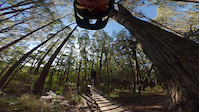
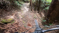
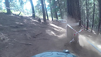
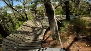
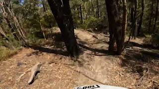
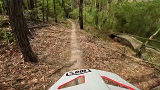
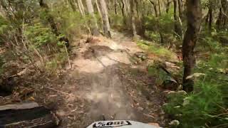
Photos of Glengarry Mountain Bike
Videos of Glengarry Mountain Bike
trail: The Rabbit Hole
0:09 |
170 |
Jul 12, 2024

trail: The Rabbit Hole
0:06 |
120 |
Jul 12, 2024
trail: ADD
0:14 |
154 |
Jan 25, 2023
trail: ADD
0:21 |
269 |
Apr 1, 2016
youtuber
![The Rockies Somewhere Good]()
trail: The Rockies
0:56 |
31 |
Feb 10, 2023 , Glengarry
youtuber
![Flow Track Somewhere Good]()
trail: Flow Track
3:17 |
40 |
Feb 10, 2023 , Glengarry
Recent Trail Reports
| status | trail | date | condition | info | user |
|---|---|---|---|---|---|
| Jump Run | May 31, 2025 @ 1:49pm May 31, 2025 | Dry | foxfraser MVP | ||
| Jump Run Link | May 31, 2025 @ 1:49pm May 31, 2025 | Dry | foxfraser MVP | ||
| Goanna | May 31, 2025 @ 1:49pm May 31, 2025 | Dry | foxfraser MVP | ||
| Return Trail | May 31, 2025 @ 1:49pm May 31, 2025 | Ideal | foxfraser MVP | ||
| Lyrebird | May 31, 2025 @ 1:49pm May 31, 2025 | Ideal | foxfraser MVP | ||
| ADD | May 31, 2025 @ 1:49pm May 31, 2025 | Ideal | foxfraser MVP | ||
| The Rabbit Hole | May 31, 2025 @ 1:49pm May 31, 2025 | Variable | foxfraser MVP | ||
| Flow Track | May 31, 2025 @ 1:49pm May 31, 2025 | Dry | foxfraser MVP | ||
| Chainsaw | May 31, 2025 @ 1:49pm May 31, 2025 | Ideal | foxfraser MVP | ||
| Strap On | May 31, 2025 @ 1:49pm May 31, 2025 | Dry | foxfraser MVP |
Activity Feed
| username | action | type | title | date |
|---|---|---|---|---|
| TravAmflow | wishlist | region | activity #92910376 | Apr 18, 2026 @ 6:15pm Apr 18, 2026 |
| skipatrol01 | wishlist | poi | activity #91867952 | Apr 3, 2026 @ 8:02pm Apr 3, 2026 |
| SimonLAqCkm | ridden | trail | activity #89328736 and 2 more | Feb 21, 2026 @ 8:26pm Feb 21, 2026 |
| eloMyc | comment | trail | activity #89002808 | Feb 15, 2026 @ 9:06pm Feb 15, 2026 |
| Beefy316 | wishlist | region | activity #88451117 | Feb 6, 2026 @ 1:46pm Feb 6, 2026 |
Recent Comments
| username | type | title | comment | date |
|---|---|---|---|---|
| trail | Direction of travel shown on the map is... | Feb 15, 2026 @ 9:06pm Feb 15, 2026 | ||
| trail | The recent work on this trail has taken it... | May 29, 2025 @ 3:24am May 29, 2025 | ||
| report | Great Ride | Oct 14, 2020 @ 3:11am Oct 14, 2020 |
Local Badges
-

10 Blue Trails176 awarded -

Epic Ride Climb 2k4 awarded -

Climbing 10k Badge11 awarded -

Climbing 100k Badge1 awarded -

Epic Ride Descent 2k4 awarded -

Descent 10k Badge11 awarded
Activity Type Stats
| activitytype | trails | distance | descent | descent distance | total vertical | rating | global rank | state rank | photos | reports | routes | ridelogs |
|---|---|---|---|---|---|---|---|---|---|---|---|---|
| Mountain Bike | 19 | 12 miles | 2,310 ft | 6 miles | 446 ft | #3,751 | #151 | 37 | 534 | 2 | 2,254 | |
| E-Bike | 19 | 12 miles | 2,310 ft | 6 miles | 446 ft | #4,412 | #206 | 5 | 513 | 1 | 261 | |
| Horse | 1 | 2 miles | 144 ft | 2,579 ft | 387 ft | 62 | ||||||
| Hike | 3 | 3 miles | 341 ft | 1 mile | 387 ft | #10,552 | #315 | 521 | 12 | |||
| Trail Running | 3 | 3 miles | 341 ft | 1 mile | 387 ft | #10,044 | #298 | 521 | 2 | |||
| Dirtbike/Moto | 1 | 2 miles | 144 ft | 2,579 ft | 387 ft | 62 | 2 |
Frequently Asked Questions About Glengarry
▼
What are the best places to ride in Glengarry?
Glengarry has 1 areas to explore for mountain biking. The top rated areas are:
▼
What are the highest rated mountain biking trails in Glengarry?
The highest rated mountain biking trails in Glengarry are:
- Stump Run (4.3/5)
- Flow Track (4.3/5)
- ADD (4.2/5)
- The Rabbit Hole (4.2/5)
- Lyrebird (4.1/5)
▼
What is the best time of the year to ride in Glengarry?
Based on ride log data, the most popular months to ride in Glengarry are:
- February (64 activities)
- January (58 activities)
- September (48 activities)
▼
Where can I park to ride in Glengarry?
There are 1 parking locations listed in Glengarry. The most popular parking spots are:
Trails
- By gtrewern
 Gmtb & contributors
 - Admins: Victoria, Gmtb, MTBEG
- #20098 - 6,438 views
- glengarry activity log | embed map of Glengarry mountain bike trails | glengarry mountain biking points of interest
Downloading of trail gps tracks in kml & gpx formats is enabled for Glengarry.
You must login to download files.