close
-
Layers w
- Weather Layers
- Pro
- Pro
- Pro
- Pro
- Pro
- Pro
- More Layers
- Pro
- Pro
- Pro
- Pro
-
Upgrade to

3D
Trail Conditions
- Unknown
- Snow Groomed
- Snow Packed
- Snow Covered
- Snow Cover Partial
- Freeze/thaw Cycle
- Icy
- Prevalent Mud
- Wet
- Variable
- Ideal
- Dry
- Very Dry
Trail Flow (Ridden Direction)
Trailforks scans users ridelogs to determine the most popular direction each trail is ridden. A good flowing trail network will have most trails flowing in a single direction according to their intension.
The colour categories are based on what percentage of riders are riding a trail in its intended direction.
The colour categories are based on what percentage of riders are riding a trail in its intended direction.
- > 96%
- > 90%
- > 80%
- > 70%
- > 50%
- < 50%
- bi-directional trail
- no data
Trail Last Ridden
Trailforks scans ridelogs to determine the last time a trail was ridden.
- < 2 days
- < 1 week
- < 2 weeks
- < 1 month
- < 6 months
- > 6 months
Trail Ridden Direction
The intended direction a trail should be ridden.
- Downhill Only
- Downhill Primary
- Both Directions
- Uphill Primary
- Uphill Only
- One Direction
Contribute Details
Colors indicate trail is missing specified detail.
- Description
- Photos
- Description & Photos
- Videos
Trail Popularity ?
Trailforks scans ridelogs to determine which trails are ridden the most in the last 9 months.
Trails are compared with nearby trails in the same city region with a possible 25 colour shades.
Think of this as a heatmap, more rides = more kinetic energy = warmer colors.
- most popular
- popular
- less popular
- not popular
ATV/ORV/OHV Filter
Max Vehicle Width
inches
US Cell Coverage
Legend

Radar Time
Activity Recordings
Trailforks uses anonymized public activity data.
?
Activity Recordings
Trailforks uses anonymized public activity data.
?
Personal Heatmap
▶
Activity Types
all
/
none
▶
Options
2
Date range
month
–
Winter Trails
Warning
A routing network for winter maps does not exist. Selecting trails using the winter trails layer has been disabled.
Missing Trails
Most Popular
Least Popular
Trails are colored based on popularity. The more popular a trail is, the more red. Less popular trails trend towards green.
Jump Magnitude Heatmap
Heatmap of where riders jump on trails. Zoom in to see individual jumps, click circles to view jump details.
BC Backroad Status
![map legend]()
Service Road Atlas is a free to use, community-driven service for viewing and creating reports on the numerous back-country service roads around B.C. and Alberta.

Slope Aspect
Direction the slope faces
Trails Deemphasized
Trails are shown in grey.
Only show trails with no bike usage.
Suggested Layers
Based on selected activity type
Save the current map location and zoom level as your default home location whenever this page is loaded.
SaveRed, Black, Blue and Green marked trails, plus some trails from races including an EWS round and a "Bike Park" area. Cafe, toilets, showers and an excellent bike shop with bike hire all on site. Gets very busy on sunny weekends.
Nearest Hospital: Borders General Hospital, Galashiels. TD6 9BS
Nearest Hospital: Borders General Hospital, Galashiels. TD6 9BS
source: Borders General Hospital
Primary Trail Type: Cross-Country
eBikes Allowed:
Yes
Shuttleable: YES
AKA: GT
Land Status: National Park
Land Manager: Forestry And Land Scotland
 google parking directions
 Access Info:
Clearly signposted on the Peebles - Innerleithen road.
Links
This region uses the Uk/Euro style trail grading system.
Activities Click to view
- Mountain Bike
193 trails
- E-Bike
190 trails
- Horse
47 trails
- Hike
81 trails
- Trail Running
80 trails
Region Details
- 56
- 17
- 26
- 33
- 56
Region Status
Open as of Jun 13, 2026Stats
- Avg Trail Rating
- Global Ranking
- #20
- Trails (view details)
- 191
- Trails Mountain Bike
- 193
- Trails E-Bike
- 190
- Trails Gravel Bike
- 3
- Trails Winter Fat Bike
- 2
- Trails Horse
- 47
- Trails Hike
- 81
- Trails Trail Running
- 80
- Total Distance
- 96 miles
- Total Descent
- 24,285 ft
- Total Vertical
- 1,471 ft
- Highest Trailhead
- 1,969 ft
- Reports
- 5,590
- Photos
- 532
- Ridden Counter
- 263,924
Popular Glentress Mountain Biking Trails
• 95 ★ 4.4 • 4,314 ft • 5 ft • 4,149 •
From the bench at the top. Great flowing descent with drops, jumps and (now slightly rough) berms. Glentress Classic. Can work with , or continued on to or
• 100 ★ 4.1 • 2,306 ft • 0 ft • 3,944 •
Fast blast. Starts flat with gentle turns then dodge the tree and onto the rebuilt table jump. Keep your speed through a few holes and into a rollercoaster like section. Hit the bridge( careful when wet) and either take the tight red...
• 95 ★ 4.3 • 3,159 ft • 0 ft • 3,872 •
Fast and pedally in parts. with fast straights, small berms and little jumps. Can be puddly in winter.
• 100 ★ 4.3 • 4,475 ft • 265 ft • 3,852 •
This is marked from the bottom (at the shop/cafe).
• 100 ★ 3.7 • 525 ft • 21 ft • 3,739 •
Popular blue difficulty family friendly singletrack. This mountain bike primary trail can be used one direction and has a easy overall physical rating with a 21 ft green climb. Trail visibility is always easy to follow. On average it takes minutes to complete this trail.
Glentress Mountain Bike Routes
★ 5.0 • 11 miles • 1,541 ft • 13 • Loop •
The Blue Route is big fun for all – from novices taking the next step up from routes to experienced...
★ 5.0 • 30 miles • 3,941 ft • 17 • Loop •
Loop of Glentress Black with a loop of Gypsy Glen added
★ 4.5 • 7 miles • 1,329 ft • 29 •
Glentress short one for a bit of easier fun
★ 5.0 • 12 miles • 2,363 ft • 30 •
Fire road from buzzards nest to the mast , follow the black to top of ,fire road round to , up to the mast...
★ 5.0 • 13 miles • 2,148 ft • 51 • Point to Point •
Bit of a mix or red and black enduro trail
Photos of Glentress Mountain Bike
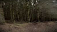
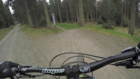
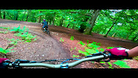
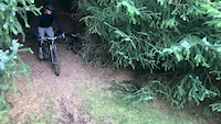
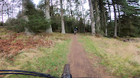
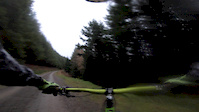
Videos of Glentress Mountain Bike
trail: Mud And Roots
0:05 |
59 |
Aug 26, 2024
trail: Mud And Roots
0:01 |
142 |
Mar 21, 2023
trail: Cool Runnings
0:53 |
356 |
Aug 8, 2019
trail: Five Year Plan
5:46 |
187 |
Jul 17, 2019
trail: Hammer Time
0:07 |
814 |
Mar 12, 2019
trail: Ho Chi Min
2:12 |
410 |
Mar 3, 2019

trail: B-Side
4:32 |
121 |
Jan 7, 2019
trail: Steep Loam
0:00 |
490 |
Jan 6, 2019
Recent Trail Reports
| status | trail | date | condition | info | user |
|---|---|---|---|---|---|
| Castle Black | Jun 13, 2026 @ 1:47pm (Europe/London) Jun 13, 2026 | Variable | andywardmanFLS GTF | ||
| Smells Like Tweed Spirit | Jun 13, 2026 @ 1:45pm (Europe/London) Jun 13, 2026 | Variable | andywardmanFLS GTF | ||
| Apple Peel | Jun 3, 2026 @ 10:21am (Europe/Isle_of_Man) Jun 3, 2026 | Ideal | Cacyn | ||
| Turn And Burn | Jun 3, 2026 @ 10:21am (Europe/Isle_of_Man) Jun 3, 2026 | Ideal | Cacyn | ||
| Access Trail | Jun 3, 2026 @ 10:21am (Europe/Isle_of_Man) Jun 3, 2026 | Ideal | Cacyn | ||
| Smells Like Tweed Spirit | Jun 3, 2026 @ 10:21am (Europe/Isle_of_Man) Jun 3, 2026 | Ideal | Cacyn | ||
| Tourist Trap | Jun 3, 2026 @ 10:21am (Europe/Isle_of_Man) Jun 3, 2026 | Ideal | Cacyn | ||
| Magic Mushroom | Jun 3, 2026 @ 10:21am (Europe/Isle_of_Man) Jun 3, 2026 | Ideal | Cacyn | ||
| Pie Run | Jun 3, 2026 @ 10:21am (Europe/Isle_of_Man) Jun 3, 2026 | Ideal | Cacyn | ||
| Hit Squad Hill | Jun 3, 2026 @ 10:21am (Europe/Isle_of_Man) Jun 3, 2026 | Ideal | Cacyn |
Activity Feed
| username | action | type | title | date |
|---|---|---|---|---|
| CharlieKMIkvA | comment | report | activity #97091984 | Jun 16, 2026 @ 12:38am 2 days |
| DaveHtbiic | ridden | trail | activity #97062711 | Jun 15, 2026 @ 1:30pm 3 days |
| jcwacky | difficultyvote | trail | activity #97030645 | Jun 15, 2026 @ 3:36am Jun 15, 2026 |
| Lexie23 | wishlist | trail | activity #97027340 | Jun 15, 2026 @ 12:55am Jun 15, 2026 |
| SashaWnxcmn | wishlist | route | activity #96942068 | Jun 14, 2026 @ 12:18am Jun 14, 2026 |
Recent Comments
| username | type | title | comment | date |
|---|---|---|---|---|
| report | The trail is so good the jump at the end is so... | Jun 16, 2026 @ 12:38am 2 days | ||
| trail | Sensational. Absolutely rapid with some rocky... | Jun 6, 2026 @ 8:50am Jun 6, 2026 | ||
| trail | Very enjoyable trail, not too crazy but you... | Jun 6, 2026 @ 8:42am Jun 6, 2026 | ||
| trail | Rode it today and there’s definitely been an... | Jun 6, 2026 @ 8:38am Jun 6, 2026 | ||
| trail | Really nice trail, technical with some steep... | Jun 6, 2026 @ 8:33am Jun 6, 2026 |
Nearby Areas
| name | distance | ||||
|---|---|---|---|---|---|
| Leithenwater Forest | 1 | 2.2 km | |||
| Cademuir | 12 | 3.4 km | |||
| Hamilton Hill | 3.5 km | ||||
| Cardrona | 1 | 2 | 3.5 km | ||
| Caberston | 3 | 3 | 4.5 km |
Local Badges
-

Trail Fairies Challenge: All The Reds11 awarded -

Trail Fairies Challenge: All the blue's79 awarded -

Completionist0 awarded
Activity Type Stats
| activitytype | trails | distance | descent | descent distance | total vertical | rating | global rank | state rank | photos | reports | routes | ridelogs |
|---|---|---|---|---|---|---|---|---|---|---|---|---|
| Mountain Bike | 193 | 95 miles | 24,173 ft | 51 miles | 1,470 ft | #20 | 530 | 5,569 | 19 | 55,046 | ||
| E-Bike | 190 | 94 miles | 23,789 ft | 50 miles | 1,470 ft | #22 | #20 | 2 | 5,193 | 4 | 9,208 | |
| Gravel Bike | 3 | #12 | #1 | 37 | 79 | |||||||
| Winter Fat Bike | 2 | #12 | #1 | 17 | 1 | |||||||
| Horse | 47 | 45 miles | 6,453 ft | 20 miles | 1,463 ft | #95 | #7 | 1,427 | ||||
| Hike | 81 | 57 miles | 8,888 ft | 25 miles | 1,463 ft | #744 | #19 | 4,583 | 277 | |||
| Trail Running | 80 | 57 miles | 8,888 ft | 25 miles | 1,463 ft | #399 | #16 | 4,583 | 925 |
Frequently Asked Questions About Glentress
▼
What are the highest rated mountain biking trails in Glentress?
The highest rated mountain biking trails in Glentress are:
- Careless Whisper (4.6/5)
- Five Year Plan (4.6/5)
- B-Side (4.5/5)
- Twitcher (4.5/5)
- Turn And Burn (4.5/5)
▼
What is the best time of the year to ride in Glentress?
Based on ride log data, the most popular months to ride in Glentress are:
- August (231 activities)
- September (228 activities)
- July (202 activities)
▼
Where can I park to ride in Glentress?
There are 5 parking locations listed in Glentress. The most popular parking spots are: View all parking and trailhead locations on the map to plan your visit.
▼
What is the longest trail in Glentress?
The longest trail in Glentress is Kipps Loop at 2.2 km. View all trails sorted by distance.
Activities
Trails
- By 20twenty-p
 TVTA & contributors
 - Admins: TVTA
- #5592 - 124,566 views
- glentress activity log | embed map of Glentress mountain bike trails | glentress mountain biking points of interest polygons
Downloading of trail gps tracks in kml & gpx formats is enabled for Glentress.
You must login to download files.