close
-
Layers w
- Weather Layers
- Pro
- Pro
- Pro
- Pro
- Pro
- Pro
- More Layers
- Pro
- Pro
- Pro
- Pro
-
Upgrade to

3D
Trail Conditions
- Unknown
- Snow Groomed
- Snow Packed
- Snow Covered
- Snow Cover Partial
- Freeze/thaw Cycle
- Icy
- Prevalent Mud
- Wet
- Variable
- Ideal
- Dry
- Very Dry
Trail Flow (Ridden Direction)
Trailforks scans users ridelogs to determine the most popular direction each trail is ridden. A good flowing trail network will have most trails flowing in a single direction according to their intension.
The colour categories are based on what percentage of riders are riding a trail in its intended direction.
The colour categories are based on what percentage of riders are riding a trail in its intended direction.
- > 96%
- > 90%
- > 80%
- > 70%
- > 50%
- < 50%
- bi-directional trail
- no data
Trail Last Ridden
Trailforks scans ridelogs to determine the last time a trail was ridden.
- < 2 days
- < 1 week
- < 2 weeks
- < 1 month
- < 6 months
- > 6 months
Trail Ridden Direction
The intended direction a trail should be ridden.
- Downhill Only
- Downhill Primary
- Both Directions
- Uphill Primary
- Uphill Only
- One Direction
Contribute Details
Colors indicate trail is missing specified detail.
- Description
- Photos
- Description & Photos
- Videos
Trail Popularity ?
Trailforks scans ridelogs to determine which trails are ridden the most in the last 9 months.
Trails are compared with nearby trails in the same city region with a possible 25 colour shades.
Think of this as a heatmap, more rides = more kinetic energy = warmer colors.
- most popular
- popular
- less popular
- not popular
ATV/ORV/OHV Filter
Max Vehicle Width
inches
US Cell Coverage
Legend

Radar Time
Activity Recordings
Trailforks uses anonymized public activity data.
?
Activity Recordings
Trailforks uses anonymized public activity data.
?
Personal Heatmap
▶
Activity Types
all
/
none
▶
Options
2
Date range
month
–
Winter Trails
Warning
A routing network for winter maps does not exist. Selecting trails using the winter trails layer has been disabled.
Missing Trails
Most Popular
Least Popular
Trails are colored based on popularity. The more popular a trail is, the more red. Less popular trails trend towards green.
Jump Magnitude Heatmap
Heatmap of where riders jump on trails. Zoom in to see individual jumps, click circles to view jump details.
BC Backroad Status
![map legend]()
Service Road Atlas is a free to use, community-driven service for viewing and creating reports on the numerous back-country service roads around B.C. and Alberta.

Slope Aspect
Direction the slope faces
Trails Deemphasized
Trails are shown in grey.
Only show trails with no bike usage.
Suggested Layers
Based on selected activity type
Save the current map location and zoom level as your default home location whenever this page is loaded.
Save
No description for Glyncorrwg has been added yet!
Login or register to submit one.
This region uses the Uk/Euro style trail grading system.
Activities Click to view
- Mountain Bike
77 trails
- E-Bike
43 trails
- Gravel Bike
13 trails
- Adaptive Bike
0 trails
- Winter Fat Bike
0 trails
- Horse
14 trails
- Hike
46 trails
- Trail Running
46 trails
Region Details
- 27
- 2
- 6
- 38
- 3
Region Status
Open as of Jun 16, 2026Stats
- Avg Trail Rating
- Trails (view details)
- 78
- Trails Mountain Bike
- 77
- Trails E-Bike
- 43
- Trails Gravel Bike
- 13
- Trails Horse
- 14
- Trails Hike
- 46
- Trails Trail Running
- 46
- Total Distance
- 65 miles
- Total Descent
- 12,769 ft
- Total Vertical
- 1,589 ft
- Highest Trailhead
- 1,947 ft
- Reports
- 768
- Photos
- 191
- Ridden Counter
- 32,294
Articles
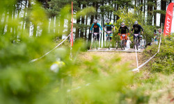
Video & Race Report: National Championships & Round 4 of the British 4x Series - Afan
Jul 2, 2019 from pinkbike.com
Afan has been part of the British 4x calendar since 2011.
Sub Regions
-
Afan Forest Park
- 2
- 6
- 38
- 3
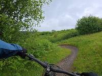
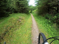
Popular Glyncorrwg Mountain Biking Trails
• 80 ★ 3.8 • 2,042 ft • 67 ft • 909 •
Popular green difficulty paved path. This mountain bike primary trail. On average it takes 9 minutes to complete this trail.
• 90 ★ 5.0 • 3,209 ft • 105 ft • 898 •
Popular red difficulty singletrack. This mountain bike primary trail can be used one direction and has a easy overall physical rating. Trail visibility is always easy to follow. On average it takes 4 minutes to complete this trail.
• 100 ★ 3.0 • 1,091 ft • 16 ft • 885 •
Popular red difficulty singletrack. This mountain bike primary trail can be used downhill only and has a moderate overall physical rating. On average it takes 1 minutes to complete this trail.
Glyncorrwg Mountain Bike Routes
★ 3.9 • 10 miles • 1,350 ft • 3 •
One of the oldest trails in Afan Forest Shut down for a considerable time for forestry works, has been...
★ 3.5 • 10 miles • 1,394 ft • 0 •
★ 4.5 • 8 miles • 1,034 ft • 0 •
4 miles • 953 ft • 0 • Loop •
Combined Black and Blue run in Blaengarw. Blue run is smooth flowing and easy to ride. Black loop is...
• 14 miles • 2,743 ft • 10 •
• 14 miles • 2,453 ft • 11 •
Photos of Glyncorrwg Mountain Bike
Videos of Glyncorrwg Mountain Bike
trail: Widow Maker
5:15 |
4 |
Jun 3, 2026
trail: Afan Valley Cycle Track
8:15 |
8 |
Dec 29, 2025
trail: Desolation
4:48 |
40 |
Jun 13, 2025

0:15 |
31 |
Sep 27, 2020

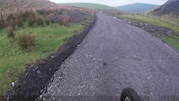
trail: Access Road
13:21 |
48 |
Apr 19, 2020
trail: White's Level
3:41 |
137 |
Nov 21, 2018
trail: Energy
0:49 |
188 |
Dec 19, 2016
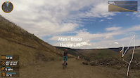
trail: Happy Life
4:35 |
189 |
May 12, 2016
Current Trail Warnings
| status | trail | date | condition | user | info |
|---|---|---|---|---|---|
| Hokey Kokey | Jun 8, 2026 @ 10:21am (Europe/London) Jun 8, 2026 | Unknown | wonkle | Trail still closed large amount of trees... |
Recent Trail Reports
| status | trail | date | condition | info | user |
|---|---|---|---|---|---|
| Omega | May 2, 2026 @ 10:17am (Europe/London) May 2, 2026 | Dry | GaryHopkins | ||
| Zig Zags | Mar 21, 2026 @ 3:39pm (Europe/London) Mar 21, 2026 | Unknown | Gazza59 | ||
| Graveyard | Mar 14, 2026 @ 9:30am (Europe/London) Mar 14, 2026 | Variable | RadBikeBro NCTC | ||
| 373 (New Option) | Mar 14, 2026 @ 9:30am (Europe/London) Mar 14, 2026 | Variable | RadBikeBro NCTC | ||
| Piccadilly | Mar 14, 2026 @ 9:30am (Europe/London) Mar 14, 2026 | Variable | RadBikeBro NCTC | ||
| Nant Y Bar | Mar 14, 2026 @ 9:30am (Europe/London) Mar 14, 2026 | Variable | RadBikeBro NCTC | ||
| Tramway | Mar 14, 2026 @ 9:30am (Europe/London) Mar 14, 2026 | Variable | RadBikeBro NCTC | ||
| Rhiwcregan | Mar 14, 2026 @ 9:30am (Europe/London) Mar 14, 2026 | Variable | RadBikeBro NCTC | ||
| Elevator | Mar 14, 2026 @ 9:30am (Europe/London) Mar 14, 2026 | Variable | RadBikeBro NCTC | ||
| In - Bye | Mar 14, 2026 @ 9:30am (Europe/London) Mar 14, 2026 | Variable | RadBikeBro NCTC |
Activity Feed
| username | action | type | title | date |
|---|---|---|---|---|
| wonkle | add | trail | activity #97318389 and 1 more | Jun 19, 2026 @ 8:07am 3 days |
| wonkle | add | trail | activity #97302626 and 5 more | Jun 19, 2026 @ 1:25am Jun 19, 2026 |
| Camerthom | comment | trail | activity #96980399 | Jun 14, 2026 @ 9:54am Jun 14, 2026 |
| wonkle | add | report | activity #96527149 | Jun 8, 2026 @ 2:23am Jun 8, 2026 |
| wonkle | add | photo | activity #96526381 and 7 more | Jun 8, 2026 @ 1:37am Jun 8, 2026 |
Recent Comments
| username | type | title | comment | date |
|---|---|---|---|---|
| trail | It’s back open…. But… it’s crap? The... | Jun 14, 2026 @ 9:54am Jun 14, 2026 | ||
| trail | Running well. Dry | Apr 28, 2026 @ 2:41pm Apr 28, 2026 | ||
| trail | Still closed | Apr 22, 2026 @ 8:34am Apr 22, 2026 | ||
| trail | Great flow to this trail | Mar 21, 2026 @ 8:36am Mar 21, 2026 | ||
| trail | Best Trail on Y Wal. | Mar 21, 2026 @ 8:34am Mar 21, 2026 |
Local Badges
-

Epic Ride Climb 2k161 awarded -

Climbing 10k Badge68 awarded -

Climbing 100k Badge2 awarded -

Epic Ride Descent 2k162 awarded -

Descent 10k Badge69 awarded -

Descent 100k Badge3 awarded
Bike & Skill Parks
| name | type | city | rating |
|---|---|---|---|
| Afan 4X Track | skill park | Glyncorrwg | |
| Afan Forest Bike Park | skill park | Glyncorrwg | |
| Llynfi BMX Track | skill park | Glyncorrwg |
Activity Type Stats
| activitytype | trails | distance | descent | descent distance | total vertical | rating | global rank | state rank | photos | reports | routes | ridelogs |
|---|---|---|---|---|---|---|---|---|---|---|---|---|
| Mountain Bike | 77 | 64 miles | 12,766 ft | 35 miles | 1,588 ft | #1,041 | #40 | 191 | 768 | 4 | 10,044 | |
| E-Bike | 43 | 41 miles | 6,385 ft | 21 miles | 1,578 ft | #2,133 | #74 | 666 | 1 | 2,769 | ||
| Gravel Bike | 13 | 6 miles | 1,096 ft | 4 miles | 991 ft | #115 | #145 | 102 | 5 | |||
| Horse | 14 | 16 miles | 2,444 ft | 9 miles | 1,132 ft | #1,058 | #49 | 197 | ||||
| Hike | 46 | 45 miles | 7,290 ft | 24 miles | 1,588 ft | #3,915 | #84 | 716 | 215 | |||
| Trail Running | 46 | 45 miles | 7,244 ft | 23 miles | 1,588 ft | #3,362 | #73 | 716 | 75 |
Frequently Asked Questions About Glyncorrwg
▼
What are the best places to ride in Glyncorrwg?
Glyncorrwg has 1 areas to explore for mountain biking. The top rated areas are:
▼
What are the highest rated mountain biking trails in Glyncorrwg?
The highest rated mountain biking trails in Glyncorrwg are:
- White's Level (4.4/5)
- The Wall (4.4/5)
- Energy (4.4/5)
- Darkside (4.4/5)
- Tramway (4.4/5)
▼
What is the best time of the year to ride in Glyncorrwg?
Based on ride log data, the most popular months to ride in Glyncorrwg are:
- July (78 activities)
- August (52 activities)
- September (50 activities)
▼
Where can I park to ride in Glyncorrwg?
There are 4 parking locations listed in Glyncorrwg. The most popular parking spots are: View all parking and trailhead locations on the map to plan your visit.
Activities
Trails
- By brenthillier
 NSMBA TRAILFORKS & contributors
 - Admins: apply
- #5565 - 6,815 views
- glyncorrwg activity log | embed map of Glyncorrwg mountain bike trails | glyncorrwg mountain biking points of interest
Downloading of trail gps tracks in kml & gpx formats is enabled for Glyncorrwg.
You must login to download files.