close
-
Layers w
- Weather Layers
- Pro
- Pro
- Pro
- Pro
- Pro
- Pro
- More Layers
- Pro
- Pro
- Pro
- Pro
-
Upgrade to

3D
Trail Conditions
- Unknown
- Snow Groomed
- Snow Packed
- Snow Covered
- Snow Cover Partial
- Freeze/thaw Cycle
- Icy
- Prevalent Mud
- Wet
- Variable
- Ideal
- Dry
- Very Dry
Trail Flow (Ridden Direction)
Trailforks scans users ridelogs to determine the most popular direction each trail is ridden. A good flowing trail network will have most trails flowing in a single direction according to their intension.
The colour categories are based on what percentage of riders are riding a trail in its intended direction.
The colour categories are based on what percentage of riders are riding a trail in its intended direction.
- > 96%
- > 90%
- > 80%
- > 70%
- > 50%
- < 50%
- bi-directional trail
- no data
Trail Last Ridden
Trailforks scans ridelogs to determine the last time a trail was ridden.
- < 2 days
- < 1 week
- < 2 weeks
- < 1 month
- < 6 months
- > 6 months
Trail Ridden Direction
The intended direction a trail should be ridden.
- Downhill Only
- Downhill Primary
- Both Directions
- Uphill Primary
- Uphill Only
- One Direction
Contribute Details
Colors indicate trail is missing specified detail.
- Description
- Photos
- Description & Photos
- Videos
Trail Popularity ?
Trailforks scans ridelogs to determine which trails are ridden the most in the last 9 months.
Trails are compared with nearby trails in the same city region with a possible 25 colour shades.
Think of this as a heatmap, more rides = more kinetic energy = warmer colors.
- most popular
- popular
- less popular
- not popular
ATV/ORV/OHV Filter
Max Vehicle Width
inches
US Cell Coverage
Legend

Radar Time
Activity Recordings
Trailforks uses anonymized public activity data.
?
Activity Recordings
Trailforks uses anonymized public activity data.
?
Personal Heatmap
▶
Activity Types
all
/
none
▶
Options
2
Date range
month
–
Winter Trails
Warning
A routing network for winter maps does not exist. Selecting trails using the winter trails layer has been disabled.
Missing Trails
Most Popular
Least Popular
Trails are colored based on popularity. The more popular a trail is, the more red. Less popular trails trend towards green.
Jump Magnitude Heatmap
Heatmap of where riders jump on trails. Zoom in to see individual jumps, click circles to view jump details.
BC Backroad Status
![map legend]()
Service Road Atlas is a free to use, community-driven service for viewing and creating reports on the numerous back-country service roads around B.C. and Alberta.

Slope Aspect
Direction the slope faces
Trails Deemphasized
Trails are shown in grey.
Only show trails with no bike usage.
Suggested Layers
Based on selected activity type
Save the current map location and zoom level as your default home location whenever this page is loaded.
Save
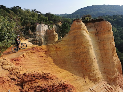
No description for Gordes has been added yet!
Login or register to submit one.
This region uses the Uk/Euro style trail grading system.
Activities Click to view
- Mountain Bike
6 trails
- E-Bike
6 trails
- Hike
4 trails
- Trail Running
4 trails
Region Details
- 2
- 2
- 1
Region Status
Open as of Aug 24, 2025Stats
- Avg Trail Rating
- Trails (view details)
- 5
- Trails Mountain Bike
- 6
- Trails E-Bike
- 6
- Trails Hike
- 4
- Trails Trail Running
- 4
- Total Distance
- 3 miles
- Total Descent Distance
- 3 miles
- Total Descent
- 1,499 ft
- Total Vertical
- 1,028 ft
- Highest Trailhead
- 1,717 ft
- Reports
- 6
- Ridden Counter
- 261
Popular Gordes Mountain Biking Trails
• 100 ★ 4.0 • 2,867 ft • 41 ft • 14 •
trés agréable descente, sans difficultés, dans le vallon
• 85 ★ 0.0 • 3,970 ft • 12 ft • 10 •
Popular green difficulty singletrack. This mountain bike primary trail can be used both directions and has a easy overall physical rating with a 12 ft blue climb. Trail visibility is always easy to follow. On average it takes 3 minutes to complete this trail.
• 5 ★ 0.0 • 2,992 ft • 9 ft • 9 •
Less popular blue difficulty singletrack. This mountain bike primary trail can be used both directions and has a hard overall physical rating with a 9 ft blue climb. Trail visibility is sometimes hard to follow. On average it takes 4 minutes to complete this trail.
• 70 ★ 4.0 • 1,001 ft • 0 ft • 9 •
Popular red difficulty singletrack. This mountain bike primary trail can be used both directions and has a moderate overall physical rating. Trail visibility is always easy to follow. On average it takes 1 minutes to complete this trail.
• 5 ★ 0.0 • 1,506 ft • 0 ft • 3 •
Less popular blue difficulty singletrack. This mountain bike primary trail can be used downhill primary and has a moderate overall physical rating with a 0 ft blue climb. Trail visibility is always easy to follow. On average it takes 1 minutes to complete this trail.
• 5 ★ 0.0 • 1 mile • 0 ft • 1 •
Less popular blue difficulty singletrack. This mountain bike primary trail can be used downhill primary and has a moderate overall physical rating with a 0 ft black diamond climb. Trail visibility is always easy to follow. On average it takes 9 minutes to complete this trail.
Recent Trail Reports
| status | trail | date | condition | info | user |
|---|---|---|---|---|---|
| La Sénancole | Aug 24, 2025 @ 9:59am Aug 24, 2025 | Unknown | ggerald84 | ||
| Village Noir | Aug 24, 2025 @ 9:59am Aug 24, 2025 | Unknown | ggerald84 | ||
| Into The Night | Apr 6, 2025 @ 8:10am Apr 6, 2025 | Dry | stumpfsr29 | ||
| Chalottes | Mar 26, 2022 @ 11:36pm Mar 26, 2022 | Very Dry | stumpfsr29 | ||
| Les Bories | Jun 12, 2021 @ 11:03pm Jun 12, 2021 | Very Dry | stumpfsr29 |
National Scenic Trails & Official Routes
-
Grande Traversée VTT du Vaucluse
- Mountain Bike
- E-Bike
Activity Feed
| username | action | type | title | date |
|---|---|---|---|---|
| ggerald84 | add | report | activity #78855412 and 1 more | Aug 24, 2025 @ 11:11am Aug 24, 2025 |
| stumpfsr29 | add | report | activity #69121899 | Apr 6, 2025 @ 8:56am Apr 6, 2025 |
| ibonze | vote | trail | activity #63876001 | Jan 1, 2025 @ 2:16am Jan 1, 2025 |
| tomzaniroli | update | trail | activity #49585602 | Feb 27, 2024 @ 5:57am Feb 27, 2024 |
| ggerald84 | vote | trail | activity #28457271 | Apr 17, 2022 @ 7:17am Apr 17, 2022 |
Local Badges
-

Completionist0 awarded -

Epic Mountain Bike Climb 2k5 awarded -

Climbing 10k Badge0 awarded -

Mountain Biking 100k Badge0 awarded -

Epic Ride Descent 2k5 awarded -

Descent 10k Badge0 awarded
Activity Type Stats
| activitytype | trails | distance | descent | descent distance | total vertical | rating | global rank | state rank | photos | reports | routes | ridelogs |
|---|---|---|---|---|---|---|---|---|---|---|---|---|
| Mountain Bike | 6 | 3 miles | 1,499 ft | 3 miles | 1,027 ft | #9,241 | #569 | 6 | 139 | |||
| E-Bike | 6 | 3 miles | 1,499 ft | 3 miles | 1,027 ft | #7,263 | #570 | 6 | 11 | |||
| Hike | 4 | 1 mile | 417 ft | 5,259 ft | 272 ft | #12,384 | #735 | 6 | 32 | |||
| Trail Running | 4 | 1 mile | 417 ft | 5,259 ft | 272 ft | #11,939 | #699 | 6 | 13 |
- By tomzaniroli
 TRAILFORKS TFFRANCE & contributors
 - Admins: tomzaniroli
- #33160 - 2,099 views
- gordes activity log | embed map of Gordes mountain bike trails |
Downloading of trail gps tracks in kml & gpx formats is enabled for Gordes.
You must login to download files.