close
-
Layers w
- Weather Layers
- Pro
- Pro
- Pro
- Pro
- Pro
- Pro
- More Layers
- Pro
- Pro
- Pro
- Pro
-
Upgrade to

3D
Trail Conditions
- Unknown
- Snow Groomed
- Snow Packed
- Snow Covered
- Snow Cover Partial
- Freeze/thaw Cycle
- Icy
- Prevalent Mud
- Wet
- Variable
- Ideal
- Dry
- Very Dry
Trail Flow (Ridden Direction)
Trailforks scans users ridelogs to determine the most popular direction each trail is ridden. A good flowing trail network will have most trails flowing in a single direction according to their intension.
The colour categories are based on what percentage of riders are riding a trail in its intended direction.
The colour categories are based on what percentage of riders are riding a trail in its intended direction.
- > 96%
- > 90%
- > 80%
- > 70%
- > 50%
- < 50%
- bi-directional trail
- no data
Trail Last Ridden
Trailforks scans ridelogs to determine the last time a trail was ridden.
- < 2 days
- < 1 week
- < 2 weeks
- < 1 month
- < 6 months
- > 6 months
Trail Ridden Direction
The intended direction a trail should be ridden.
- Downhill Only
- Downhill Primary
- Both Directions
- Uphill Primary
- Uphill Only
- One Direction
Contribute Details
Colors indicate trail is missing specified detail.
- Description
- Photos
- Description & Photos
- Videos
Trail Popularity ?
Trailforks scans ridelogs to determine which trails are ridden the most in the last 9 months.
Trails are compared with nearby trails in the same city region with a possible 25 colour shades.
Think of this as a heatmap, more rides = more kinetic energy = warmer colors.
- most popular
- popular
- less popular
- not popular
ATV/ORV/OHV Filter
Max Vehicle Width
inches
US Cell Coverage
Legend

Radar Time
Activity Recordings
Trailforks uses anonymized public activity data.
?
Activity Recordings
Trailforks uses anonymized public activity data.
?
Personal Heatmap
▶
Activity Types
all
/
none
▶
Options
2
Date range
month
–
Winter Trails
Warning
A routing network for winter maps does not exist. Selecting trails using the winter trails layer has been disabled.
Missing Trails
Most Popular
Least Popular
Trails are colored based on popularity. The more popular a trail is, the more red. Less popular trails trend towards green.
Jump Magnitude Heatmap
Heatmap of where riders jump on trails. Zoom in to see individual jumps, click circles to view jump details.
BC Backroad Status
![map legend]()
Service Road Atlas is a free to use, community-driven service for viewing and creating reports on the numerous back-country service roads around B.C. and Alberta.

Slope Aspect
Direction the slope faces
Trails Deemphasized
Trails are shown in grey.
Only show trails with no bike usage.
Suggested Layers
Based on selected activity type
Save the current map location and zoom level as your default home location whenever this page is loaded.
Save
No description for Goritsa has been added yet!
Login or register to submit one.
 google parking directions
Primary Trail Type: Cross-Country
google parking directions Activities Click to view
- Mountain Bike
8 trails
- E-Bike
8 trails
- Hike
8 trails
- Trail Running
8 trails
Region Details
- 1
- 4
- 3
Region Status
Open as of Dec 26, 2025Stats
- Avg Trail Rating
- Trails (view details)
- 8
- Trails Mountain Bike
- 8
- Trails E-Bike
- 8
- Trails Hike
- 8
- Trails Trail Running
- 8
- Total Distance
- 4 miles
- Total Descent Distance
- 3 miles
- Total Descent
- 1,751 ft
- Total Vertical
- 508 ft
- Highest Trailhead
- 606 ft
- Reports
- 13
- Photos
- 16
- Ridden Counter
- 99
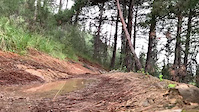
Popular Goritsa Mountain Biking Trails
• 35 ★ 5.0 • 3,612 ft • 4 ft • 13 •
Less popular green difficulty singletrack. This mountain bike primary trail can be used both directions and has a easy overall physical rating. It features rock garden. Trail visibility is always easy to follow. On average it takes 5 minutes to complete this trail.
• 100 ★ 5.0 • 3,842 ft • 29 ft • 12 •
It starts with a quite rocky section and after the left turn it's a pretty fun flowy singletrack with couple of berms and a drop.
• 70 ★ 5.0 • 1,355 ft • 4 ft • 11 •
Popular green difficulty singletrack. This mountain bike primary trail can be used both directions and has a easy overall physical rating. It features rock face and rock garden. Trail visibility is always easy to follow. On average it takes 1 minutes to complete this trail.
• 95 ★ 5.0 • 1,631 ft • 0 ft • 9 •
Popular green difficulty singletrack. This mountain bike primary trail can be used both directions. On average it takes 1 minutes to complete this trail.
• 65 ★ 5.0 • 2,277 ft • 63 ft • 9 •
Moderately popular green difficulty singletrack. This mountain bike primary trail can be used both directions and has a easy overall physical rating. On average it takes 3 minutes to complete this trail.
• 55 ★ 5.0 • 1,467 ft • 0 ft • 8 •
Moderately popular blue difficulty singletrack. This mountain bike primary trail can be used both directions and has a easy overall physical rating. It features berm. On average it takes 4 minutes to complete this trail.
• 50 ★ 5.0 • 2,329 ft • 5 ft • 7 •
Moderately popular blue difficulty singletrack. This mountain bike primary trail can be used both directions. On average it takes 3 minutes to complete this trail.
Photos of Goritsa Mountain Bike
Videos of Goritsa Mountain Bike
trail: Red String
0:14 |
17 |
Dec 26, 2025
0:48 |
8 |
Dec 26, 2025
Recent Trail Reports
| status | trail | date | condition | info | user |
|---|---|---|---|---|---|
| Godzilla | Dec 26, 2025 @ 7:14pm (Europe/Athens) Dec 26, 2025 | Variable | konstantinoskaraiskos | ||
| Technician | Dec 26, 2025 @ 7:13pm (Europe/Athens) Dec 26, 2025 | Unknown | konstantinoskaraiskos | ||
| Red String | Dec 26, 2025 @ 7:12pm (Europe/Athens) Dec 26, 2025 | Dry | konstantinoskaraiskos | ||
| Pegasus | Dec 26, 2025 @ 7:11pm (Europe/Athens) Dec 26, 2025 | Dry | konstantinoskaraiskos | ||
| Spectral | Dec 26, 2025 @ 7:06pm (Europe/Athens) Dec 26, 2025 | Ideal | konstantinoskaraiskos | ||
| Hero’s | Dec 7, 2021 @ 11:07pm Dec 7, 2021 | Dry | konstantinoskaraiskos |
Activity Feed
| username | action | type | title | date |
|---|---|---|---|---|
| blad | wishlist | region | activity #95928805 | May 31, 2026 @ 5:17am May 31, 2026 |
| jacykay | ridden | trail | activity #95046832 | May 19, 2026 @ 9:30am May 19, 2026 |
| konstantinoskaraiskos | add | report | activity #86091696 and 4 more | Dec 26, 2025 @ 9:08am Dec 26, 2025 |
| konstantinoskaraiskos | checkin | trail | activity #86090206 and 5 more | Dec 26, 2025 @ 8:39am Dec 26, 2025 |
| konstantinoskaraiskos | add | video | activity #86090129 and 1 more | Dec 26, 2025 @ 8:38am Dec 26, 2025 |
Recent Comments
| username | type | title | comment | date |
|---|---|---|---|---|
| trail | seems more like a blue line to me ;) | Jul 13, 2023 @ 4:55am Jul 13, 2023 |
Nearby Areas
| name | distance | ||||
|---|---|---|---|---|---|
| Mount Pelion | 3 | 7 | 1 | 6.1 km |
Activity Type Stats
| activitytype | trails | distance | descent | descent distance | total vertical | rating | global rank | state rank | photos | reports | routes | ridelogs |
|---|---|---|---|---|---|---|---|---|---|---|---|---|
| Mountain Bike | 8 | 4 miles | 1,752 ft | 3 miles | 509 ft | #3,421 | #25 | 16 | 13 | 378 | ||
| E-Bike | 8 | 4 miles | 1,752 ft | 3 miles | 509 ft | #4,256 | #39 | 13 | 2 | |||
| Hike | 8 | 4 miles | 1,752 ft | 3 miles | 509 ft | #7,959 | #54 | 13 | 15 | |||
| Trail Running | 8 | 4 miles | 1,752 ft | 3 miles | 509 ft | #7,097 | #54 | 13 | 8 |
Frequently Asked Questions About Goritsa
▼
What are the highest rated mountain biking trails in Goritsa?
The highest rated mountain biking trails in Goritsa are:
- Spectral (4.1/5)
- Hero’s (4.1/5)
- Roach Hit (4.1/5)
- Pegasus (4.1/5)
- Red String (4.1/5)
▼
Where can I park to ride in Goritsa?
There are 1 parking locations listed in Goritsa. The most popular parking spots are:
▼
What is the longest trail in Goritsa?
The longest trail in Goritsa is Spectral at 3,842 ft. View all trails sorted by distance.
▼
How many trails are in Goritsa?
Goritsa has a total of 8 trails. Browse top mountain biking trails in Goritsa to find detailed information including difficulty ratings, distances, and trail conditions.
- By 1negk
 & contributors
 - Admins: konstantinoskaraiskos
- #43912 - 888 views
- goritsa activity log | embed map of Goritsa mountain bike trails | goritsa mountain biking points of interest
Downloading of trail gps tracks in kml & gpx formats is enabled for Goritsa.
You must login to download files.