close
-
Layers w
- Weather Layers
- Pro
- Pro
- Pro
- Pro
- Pro
- Pro
- More Layers
- Pro
- Pro
- Pro
- Pro
-
Upgrade to

3D
Trail Conditions
- Unknown
- Snow Groomed
- Snow Packed
- Snow Covered
- Snow Cover Partial
- Freeze/thaw Cycle
- Icy
- Prevalent Mud
- Wet
- Variable
- Ideal
- Dry
- Very Dry
Trail Flow (Ridden Direction)
Trailforks scans users ridelogs to determine the most popular direction each trail is ridden. A good flowing trail network will have most trails flowing in a single direction according to their intension.
The colour categories are based on what percentage of riders are riding a trail in its intended direction.
The colour categories are based on what percentage of riders are riding a trail in its intended direction.
- > 96%
- > 90%
- > 80%
- > 70%
- > 50%
- < 50%
- bi-directional trail
- no data
Trail Last Ridden
Trailforks scans ridelogs to determine the last time a trail was ridden.
- < 2 days
- < 1 week
- < 2 weeks
- < 1 month
- < 6 months
- > 6 months
Trail Ridden Direction
The intended direction a trail should be ridden.
- Downhill Only
- Downhill Primary
- Both Directions
- Uphill Primary
- Uphill Only
- One Direction
Contribute Details
Colors indicate trail is missing specified detail.
- Description
- Photos
- Description & Photos
- Videos
Trail Popularity ?
Trailforks scans ridelogs to determine which trails are ridden the most in the last 9 months.
Trails are compared with nearby trails in the same city region with a possible 25 colour shades.
Think of this as a heatmap, more rides = more kinetic energy = warmer colors.
- most popular
- popular
- less popular
- not popular
ATV/ORV/OHV Filter
Max Vehicle Width
inches
US Cell Coverage
Legend

Radar Time
Activity Recordings
Trailforks uses anonymized public activity data.
?
Activity Recordings
Trailforks uses anonymized public activity data.
?
Personal Heatmap
▶
Activity Types
all
/
none
▶
Options
2
Date range
month
–
Winter Trails
Warning
A routing network for winter maps does not exist. Selecting trails using the winter trails layer has been disabled.
Missing Trails
Most Popular
Least Popular
Trails are colored based on popularity. The more popular a trail is, the more red. Less popular trails trend towards green.
Jump Magnitude Heatmap
Heatmap of where riders jump on trails. Zoom in to see individual jumps, click circles to view jump details.
BC Backroad Status
![map legend]()
Service Road Atlas is a free to use, community-driven service for viewing and creating reports on the numerous back-country service roads around B.C. and Alberta.

Slope Aspect
Direction the slope faces
Trails Deemphasized
Trails are shown in grey.
Only show trails with no bike usage.
Suggested Layers
Based on selected activity type
Save the current map location and zoom level as your default home location whenever this page is loaded.
SaveGran Canaria is the third-largest and second-most-populous island of the Canary Islands, an archipelago off the Atlantic coast of Northwest Africa which is part of Spain. As of 2019 the island had a population of 851,231 that constitutes approximately 40% of the population of the archipelago. Las Palmas de Gran Canaria, the capital of the island, is the biggest city of the Canary Islands and the ninth of Spain.
Gran Canaria is located in the Atlantic Ocean in a region known as Macaronesia about 150 kilometres (93 mi) off the northwestern coast of Africa and about 1,350 km (840 mi) from Europe. With an area of 1,560 km2 (602 sq. mi) and an altitude of 1,956 m (6,417 ft) at Morro de la Agujereada, Gran Canaria is the third largest island of the archipelago in both area and altitude. Gran Canaria is also the third most populated island in Spain.
Gran Canaria is located in the Atlantic Ocean in a region known as Macaronesia about 150 kilometres (93 mi) off the northwestern coast of Africa and about 1,350 km (840 mi) from Europe. With an area of 1,560 km2 (602 sq. mi) and an altitude of 1,956 m (6,417 ft) at Morro de la Agujereada, Gran Canaria is the third largest island of the archipelago in both area and altitude. Gran Canaria is also the third most populated island in Spain.
source: Wikipedia
eBikes Allowed:
Yes
AKA: Las Palmas
This region uses the Uk/Euro style trail grading system.
Activities Click to view
- Mountain Bike
258 trails
- E-Bike
257 trails
- Horse
77 trails
- Hike
257 trails
- Trail Running
257 trails
Region Details
- 85
- 35
- 87
- 41
- 3
Stats
- Avg Trail Rating
- Trails (view details)
- 251
- Trails Mountain Bike
- 258
- Trails E-Bike
- 257
- Trails Horse
- 77
- Trails Hike
- 257
- Trails Trail Running
- 257
- Total Distance
- 332 miles
- Total Descent
- 98,708 ft
- Total Vertical
- 6,316 ft
- Highest Trailhead
- 6,340 ft
- Reports
- 277
- Photos
- 140
- Ridden Counter
- 7,050
Sub Regions
- Fontanales (42)
- Valle de Agaete (33)
- Las Palmas (50)
- Tejeda (90)
- Telde (40)
- Valle de Valsequillo (39)
- Teror (5)
- San Mateo (6)
Popular Gran Canaria Mountain Biking Trails
• 100 ★ 0.0 • 1,263 ft • 5 ft • 272 •
Pequeño sendero paralelo a la GC-60, marcado como sendero de senderismo con una señal. Genial para intentar pasar sobre el pequeño canal de agua sin poner pie! Tiny bit of single trail parallel to the GC-60, marked as hiking with a...
• 100 ★ 5.0 • 3,314 ft • 10 ft • 145 •
Popular blue difficulty singletrack. This multi-use trail can be used downhill primary. It features berm, jump and gap jump. Trail visibility is always easy to follow. On average it takes 7 minutes to complete this trail.
• 95 ★ 0.0 • 1,099 ft • 2 ft • 137 •
Pequeño sendero paralelo a la GC-60, podria ser verde pero hay algunas secciones de rocas. Tiny piece of single track parallel to the GC-60 road, most of it could be green, but a few sections with rocks and forcing you to climb up a...
• 90 ★ 0.0 • 3,307 ft • 181 ft • 127 •
Popular green difficulty singletrack. This multi-use trail can be used both directions. Trail visibility is always easy to follow. On average it takes 4 minutes to complete this trail.
• 90 ★ 4.5 • 1 mile • 31 ft • 101 •
Highly rated popular red difficulty singletrack. This multi-use trail can be used downhill primary and has a hard overall physical rating with a 31 ft double black diamond climb. It features rock garden. Trail visibility is always easy to follow. On average it takes 39 minutes to complete this trail.
Gran Canaria Mountain Bike Routes
★ 5.0 • 22 miles • 3,223 ft • 16 • Point to Point •
Super Enduro route with 2.900m of descent from the top of the island to the sea. Starts at the highest...
26 miles • 4,568 ft • 11 • Loop •
Route in Maspalomas from "Life on 2 wheels" following road up and descening down handbuilt mtb track. Go...
★ 5.0 • 21 miles • 2,652 ft • 0 • Loop •
Se puede salir desde el Centro de Salud de Maspalomas. En sentido horario lo he hecho yo siempre, los...
22 miles • 1,966 ft • 7 • Shuttled •
Snow To Sea Series +2300m of descent from Pico de Las Nieves to Maspalomas
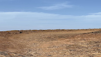
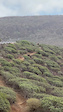
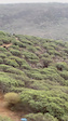
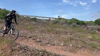
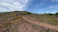
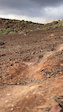
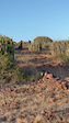
Photos of Gran Canaria Mountain Bike
Videos of Gran Canaria Mountain Bike
trail: La Cruz
0:11 |
|
Jan 11, 2024
trail: La Cruz
0:17 |
38 |
Jan 11, 2024
trail: La Cruz
0:17 |
8 |
Jan 11, 2024
trail: La Cruz
0:14 |
10 |
Jan 11, 2024
trail: La Cruz
0:10 |
26 |
Jan 11, 2024
trail: La Cruz
0:14 |
14 |
Jan 11, 2024
trail: La Cruz
0:31 |
8 |
Jan 11, 2024
trail: La Cruz
0:28 |
10 |
Jan 11, 2024
Recent Trail Reports
| status | trail | date | condition | info | user |
|---|---|---|---|---|---|
| Armonia Gran Canaria | Jun 20, 2026 @ 10:34pm (Atlantic/Canary) 10 hours | Very Dry | chory | ||
| Los Juncos Gran Canaria | Jun 20, 2026 @ 10:33pm (Atlantic/Canary) 10 hours | Very Dry | chory | ||
| Llanos de La Pez Fontanales | Jun 20, 2026 @ 10:29pm (Atlantic/Canary) 10 hours | Very Dry | chory | ||
| Cuevas Del Corcho Gran Canaria | Jun 20, 2026 @ 10:26pm (Atlantic/Canary) 10 hours | Unknown | chory | ||
| Barranco de Fataga Tejeda | Mar 30, 2026 @ 1:21am (Atlantic/Canary) Mar 29, 2026 | Unknown | marco-xc-switzerland | ||
| Barranco de Guiniguada Área Metropolitana de Las Palmas | Mar 29, 2026 @ 10:30pm (Atlantic/Canary) Mar 29, 2026 | Prevalent Mud | Jonas24SFJ3 | ||
| Comunidad La Lumbre Tejeda | Feb 1, 2026 @ 9:06am (Atlantic/Canary) Feb 1, 2026 | Dry | alessandropessione | ||
| La Lumbre Tejeda | Feb 1, 2026 @ 9:06am (Atlantic/Canary) Feb 1, 2026 | Dry | alessandropessione | ||
| Barranquillo de los Negros San Mateo | Feb 1, 2026 @ 9:06am (Atlantic/Canary) Feb 1, 2026 | Dry | alessandropessione | ||
| Piedra de Fuego Gran Canaria | Feb 1, 2026 @ 9:06am (Atlantic/Canary) Feb 1, 2026 | Dry | alessandropessione |
Activity Feed
| username | action | type | title | date |
|---|---|---|---|---|
| chory | add | report | activity #97433642 | Jun 20, 2026 @ 2:29pm 10 hours |
| chory | add | report | activity #97433369 and 2 more | Jun 20, 2026 @ 2:26pm 10 hours |
| Christof7MD7CD | wishlist | trail | activity #95988614 | May 31, 2026 @ 5:04pm May 31, 2026 |
| Christof7MD7CD | wishlist | trail | activity #95988384 | May 31, 2026 @ 5:00pm May 31, 2026 |
| Christof7MD7CD | wishlist | trail | activity #95988353 and 1 more | May 31, 2026 @ 5:00pm May 31, 2026 |
Recent Comments
| username | type | title | comment | date |
|---|---|---|---|---|
| trail | Bullshit Trail! Especially the last part with... | Apr 5, 2026 @ 3:04am Apr 5, 2026 | ||
| trail | Difficulty is more black than blue. Forbiden... | Feb 9, 2026 @ 6:13am Feb 9, 2026 | ||
| trail | Fun trail - carry on down the hill , many... | Oct 28, 2025 @ 5:36am Oct 28, 2025 | ||
| trail | Avoid at all cost, last hike and bike section... | Oct 15, 2025 @ 3:58pm Oct 15, 2025 | ||
| trail | Rideable singletrack, ideal for looping back... | Oct 4, 2025 @ 2:32am Oct 4, 2025 |
Local Badges
-

Descent 10k Badge29 awarded -

Descent 100k Badge0 awarded -
Descent 100k Badge2 awarded -
Descent 100k Badge0 awarded -
Descent 100k Badge1 awarded -
Descent 10k Badge5 awarded
Bike & Skill Parks
| name | type | city | rating |
|---|---|---|---|
| Cross / enduro miligvis ??? | skill park | Las Palmas |
Activity Type Stats
| activitytype | trails | distance | descent | descent distance | total vertical | rating | global rank | state rank | photos | reports | routes | ridelogs |
|---|---|---|---|---|---|---|---|---|---|---|---|---|
| Mountain Bike | 258 | 332 miles | 98,707 ft | 183 miles | 6,316 ft | 119 | 277 | 11 | 15,994 | |||
| E-Bike | 257 | 332 miles | 98,707 ft | 183 miles | 6,316 ft | 21 | 272 | 11 | 1,332 | |||
| Horse | 77 | 157 miles | 26,188 ft | 65 miles | 6,109 ft | 42 | ||||||
| Hike | 257 | 332 miles | 98,707 ft | 183 miles | 6,316 ft | 277 | 1 | 1,416 | ||||
| Trail Running | 257 | 332 miles | 98,707 ft | 183 miles | 6,316 ft | 277 | 1 | 451 |
Frequently Asked Questions About Gran Canaria
▼
What are the best places to ride in Gran Canaria?
Gran Canaria has 4 areas to explore for mountain biking. The top rated areas are:
▼
What are the highest rated mountain biking trails in Gran Canaria?
The highest rated mountain biking trails in Gran Canaria are:
- La Cruz (4.3/5)
- Degollada del Diablo (4.3/5)
- Yegua Lower (4.2/5)
- Amurga (4.2/5)
- Yegua Upper (4.2/5)
▼
What is the best time of the year to ride in Gran Canaria?
Based on ride log data, the most popular months to ride in Gran Canaria are:
- December (15 activities)
- November (15 activities)
- January (15 activities)
▼
What is the longest trail in Gran Canaria?
The longest trail in Gran Canaria is Camino de Güigüí Grande at 6.5 miles. View all trails sorted by distance.
Activities
Trails
- By AdamPonec
 & contributors
 - Admins: mul0w, elyari, AMG, juanx, Angelreing, not-really
- #14967 - 22,199 views
- gran canaria activity log | embed map of Gran Canaria mountain bike trails | gran canaria mountain biking points of interest polygons
Downloading of trail gps tracks in kml & gpx formats is enabled for Gran Canaria.
You must login to download files.