close
-
Layers w
- Weather Layers
- Pro
- Pro
- Pro
- Pro
- Pro
- Pro
- More Layers
- Pro
- Pro
- Pro
- Pro
-
Upgrade to

3D
Trail Conditions
- Unknown
- Snow Groomed
- Snow Packed
- Snow Covered
- Snow Cover Partial
- Freeze/thaw Cycle
- Icy
- Prevalent Mud
- Wet
- Variable
- Ideal
- Dry
- Very Dry
Trail Flow (Ridden Direction)
Trailforks scans users ridelogs to determine the most popular direction each trail is ridden. A good flowing trail network will have most trails flowing in a single direction according to their intension.
The colour categories are based on what percentage of riders are riding a trail in its intended direction.
The colour categories are based on what percentage of riders are riding a trail in its intended direction.
- > 96%
- > 90%
- > 80%
- > 70%
- > 50%
- < 50%
- bi-directional trail
- no data
Trail Last Ridden
Trailforks scans ridelogs to determine the last time a trail was ridden.
- < 2 days
- < 1 week
- < 2 weeks
- < 1 month
- < 6 months
- > 6 months
Trail Ridden Direction
The intended direction a trail should be ridden.
- Downhill Only
- Downhill Primary
- Both Directions
- Uphill Primary
- Uphill Only
- One Direction
Contribute Details
Colors indicate trail is missing specified detail.
- Description
- Photos
- Description & Photos
- Videos
Trail Popularity ?
Trailforks scans ridelogs to determine which trails are ridden the most in the last 9 months.
Trails are compared with nearby trails in the same city region with a possible 25 colour shades.
Think of this as a heatmap, more rides = more kinetic energy = warmer colors.
- most popular
- popular
- less popular
- not popular
ATV/ORV/OHV Filter
Max Vehicle Width
inches
US Cell Coverage
Legend

Radar Time
Activity Recordings
Trailforks uses anonymized public activity data.
?
Activity Recordings
Trailforks uses anonymized public activity data.
?
Personal Heatmap
▶
Activity Types
all
/
none
▶
Options
2
Date range
month
–
Winter Trails
Warning
A routing network for winter maps does not exist. Selecting trails using the winter trails layer has been disabled.
Missing Trails
Most Popular
Least Popular
Trails are colored based on popularity. The more popular a trail is, the more red. Less popular trails trend towards green.
Jump Magnitude Heatmap
Heatmap of where riders jump on trails. Zoom in to see individual jumps, click circles to view jump details.
BC Backroad Status
![map legend]()
Service Road Atlas is a free to use, community-driven service for viewing and creating reports on the numerous back-country service roads around B.C. and Alberta.

Slope Aspect
Direction the slope faces
Trails Deemphasized
Trails are shown in grey.
Only show trails with no bike usage.
Suggested Layers
Based on selected activity type
Save the current map location and zoom level as your default home location whenever this page is loaded.
Save
No description for Granby has been added yet!
Login or register to submit one.
Activities Click to view
- Mountain Bike
89 trails
- E-Bike
60 trails
- Gravel Bike
0 trails
- Adaptive Bike
0 trails
- Horse
21 trails
- Hike
51 trails
- Trail Running
45 trails
- Dirtbike/Moto
5 trails
- Snowshoe
6 trails
- Downhill Ski
40 trails
- Nordic Ski
62 trails
Region Details
- 12
- 1
- 27
- 27
- 17
- 3
Region Status
Caution as of Jun 6, 2026Stats
- Avg Trail Rating
- Trails (view details)
- 186
- Trails Mountain Bike
- 89
- Trails E-Bike
- 60
- Trails Horse
- 21
- Trails Hike
- 51
- Trails Trail Running
- 45
- Trails Dirtbike/Moto
- 5
- Trails ATV/ORV/OHV
- 2
- Trails Snowmobile
- 2
- Trails Snowshoe
- 6
- Trails Downhill Ski
- 40
- Trails Nordic Ski
- 62
- Total Distance
- 252 miles
- Total Descent
- 49,837 ft
- Total Vertical
- 3,552 ft
- Highest Trailhead
- 11,543 ft
- Reports
- 371
- Photos
- 208
- Ridden Counter
- 13,221
Sub Regions
-
Bowen Gulch Protection Area
- 2
-
Granby Ranch
- 17
- 10
- 14
- 3
-
Troublesome
- 2
Popular Granby Mountain Biking Trails
• 95 ★ 5.0 • 1,546 ft • 6 ft • 397 •
The bottom of / as they merge and come into the base area. Berms and dirt jumps flowing into 3 large wooden/metal jumps.
• 100 ★ 4.4 • 4,696 ft • 0 ft • 247 •
Long and technical rock drops all the way down until it meets up with the jump line just above the base of the resort.
• 70 ★ 5.0 • 2,253 ft • 0 ft • 244 •
Popular blue difficulty singletrack. This mountain bike primary trail can be used downhill only and has a moderate overall physical rating. On average it takes 2 minutes to complete this trail.
• 55 ★ 3.7 • 1 mile • 491 ft • 222 •
Moderately popular blue difficulty singletrack. This mountain bike primary trail can be used both directions. On average it takes 1 minutes to complete this trail.
• 45 ★ 0.0 • 3,046 ft • 68 ft • 210 •
Moderately popular green difficulty singletrack. This mountain bike primary trail can be used both directions. On average it takes 2 minutes to complete this trail.
• 90 ★ 4.8 • 1,759 ft • 0 ft • 189 •
A jump line trail that branches off from . Large flowing berms with 10 foot table top jumps.
Granby Mountain Bike Routes
15 miles • 2,343 ft • 1 •
4 miles • 165 ft • 1 •
18 miles • 2,215 ft • 0 •
22 miles • 5,163 ft • 0 •
15 miles • 2,395 ft • 11 • Loop • Race •
This is the 2nd Loop of the G3 Stage Race
• 5 miles • 668 ft • 1 •
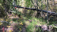
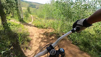
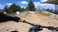
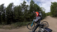
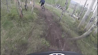
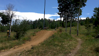
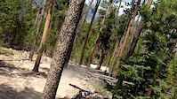
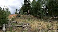
Photos of Granby Mountain Bike
Videos of Granby Mountain Bike
trail: Caribou
0:07 |
28 |
Sep 18, 2022
trail: Tron
0:14 |
94 |
Aug 6, 2022
trail: Cougar
3:49 |
137 |
Jul 20, 2021
trail: Lower Backside
4:29 |
97 |
Sep 16, 2019
trail: Drifter
7:18 |
166 |
Dec 10, 2018
trail: Stranger
0:08 |
138 |
Sep 7, 2018
trail: Stranger
0:15 |
80 |
Sep 7, 2018
trail: Drifter
0:09 |
94 |
Sep 7, 2018
Current Trail Warnings
| status | trail | date | condition | user | info |
|---|---|---|---|---|---|
| Cougar | Jun 6, 2026 @ 11:52am (America/Denver) Jun 6, 2026 | Unknown | rwill722 |
Recent Trail Reports
| status | trail | date | condition | info | user |
|---|---|---|---|---|---|
| Fraser to Granby | Aug 28, 2025 @ 7:02am Aug 28, 2025 | Ideal | markegge | ||
| Winter Park to Granby Trail | Aug 28, 2025 @ 7:02am Aug 28, 2025 | Dry | markegge | ||
| Gilsonite Trail | Aug 28, 2025 @ 2:15pm Aug 28, 2025 | Unknown | markegge | ||
| CDT - Arapaho Ridge | Aug 27, 2025 @ 11:33am Aug 27, 2025 | Ideal | markegge | ||
| CDT - High Lonesome | Jul 28, 2025 @ 8:44am Jul 28, 2025 | Dry | carsonxconthetrails | ||
| Caribou | Jul 28, 2025 @ 8:36am Jul 28, 2025 | Dry | carsonxconthetrails | ||
| Strawberry Lake | May 23, 2025 @ 12:50pm May 23, 2025 | Variable | spillcoleman | ||
| Doe Creek West | Sep 12, 2024 @ 1:39pm Sep 12, 2024 | Dry | earrieta | ||
| Doe Creek East Trail | Sep 12, 2024 @ 1:39pm Sep 12, 2024 | Ideal | earrieta | ||
| Ballroom Black | Aug 4, 2024 @ 9:05am Aug 4, 2024 | Very Dry | BetterRide |
National Scenic Trails & Official Routes
-
Continental Divide Trail
- Mountain Bike
- Hike
- Trail Running

Activity Feed
| username | action | type | title | date |
|---|---|---|---|---|
| Crisgo719 | ridden | trail | activity #97599151 | Jun 22, 2026 @ 7:11pm 12 mins |
| 31mpXz | ridden | trail | activity #96763070 and 2 more | Jun 11, 2026 @ 3:01pm Jun 11, 2026 |
| 31mpXz | ridden | trail | activity #96753423 and 3 more | Jun 11, 2026 @ 11:59am Jun 11, 2026 |
| UncleAL | wishlist | region | activity #96611171 | Jun 9, 2026 @ 9:30am Jun 9, 2026 |
| lukej3032 | wishlist | region | activity #96428250 | Jun 6, 2026 @ 8:47pm Jun 6, 2026 |
Recent Comments
| username | type | title | comment | date |
|---|---|---|---|---|
| trail | P | Jun 13, 2025 @ 7:08pm Jun 13, 2025 | ||
| trail | Don’t even think about riding up, should be... | Jul 31, 2024 @ 8:05pm Jul 31, 2024 | ||
| trail | Very loose and rocky, this may have once been... | Jul 26, 2024 @ 3:10pm Jul 26, 2024 | ||
| trail | A little loose but all fun | Jun 13, 2024 @ 8:41pm Jun 13, 2024 | ||
| trail | I thought this trail was a lot of fun to ride... | Aug 20, 2023 @ 6:38pm Aug 20, 2023 |
Local Badges
-

10 Green Trails40 awarded -

10 Blue Trails66 awarded -

10 Black Trails34 awarded -

Epic Ride Climb 2k55 awarded -

Climbing 10k Badge23 awarded -

Climbing 100k Badge1 awarded
Bike & Skill Parks
| name | type | city | rating |
|---|---|---|---|
| Granby Ranch | bike park | Granby |
Activity Type Stats
| activitytype | trails | distance | descent | descent distance | total vertical | rating | global rank | state rank | photos | reports | routes | ridelogs |
|---|---|---|---|---|---|---|---|---|---|---|---|---|
| Mountain Bike | 89 | 180 miles | 32,844 ft | 86 miles | 3,553 ft | #967 | #383 | 207 | 318 | 7 | 6,055 | |
| E-Bike | 60 | 119 miles | 22,838 ft | 56 miles | 2,684 ft | #1,164 | #825 | 266 | 166 | |||
| Horse | 21 | 58 miles | 9,272 ft | 23 miles | 3,255 ft | #1,012 | #669 | 175 | 1 | |||
| Hike | 51 | 159 miles | 23,402 ft | 69 miles | 3,553 ft | #1,409 | #641 | 1 | 296 | 4 | 1,136 | |
| Trail Running | 45 | 147 miles | 22,116 ft | 64 miles | 3,553 ft | #1,347 | #486 | 293 | 4 | 135 | ||
| Dirtbike/Moto | 5 | 72 miles | 8,770 ft | 28 miles | 2,175 ft | #594 | #199 | 110 | 1 | 5 | ||
| ATV/ORV/OHV | 2 | 12 miles | 472 ft | 2 miles | 2,034 ft | 110 | 1 | |||||
| Snowmobile | 2 | 12 miles | 472 ft | 2 miles | 2,034 ft | 52 | 1 | 2 | ||||
| Snowshoe | 6 | 23 miles | 1,886 ft | 6 miles | 2,707 ft | #607 | #239 | 53 | 3 | 44 | ||
| Downhill Ski | 40 | 13 miles | 9,908 ft | 13 miles | 814 ft | #503 | #213 | 51 | 318 | |||
| Nordic Ski | 62 | 53 miles | 4,101 ft | 17 miles | 2,461 ft | #193 | #52 | 53 | 2,099 |
Frequently Asked Questions About Granby
▼
What are the best places to ride in Granby?
Granby has 4 areas to explore for mountain biking. The top rated areas are:
▼
What are the highest rated mountain biking trails in Granby?
The highest rated mountain biking trails in Granby are:
- Ashy Larry (4.3/5)
- CDT - Arapaho Ridge (4.2/5)
- Upper Backside (4.2/5)
- Yin (4.2/5)
- Caribou (4.1/5)
▼
What is the best time of the year to ride in Granby?
Based on ride log data, the most popular months to ride in Granby are:
- July (162 activities)
- August (103 activities)
- September (86 activities)
▼
Where can I park to ride in Granby?
There are 19 parking locations listed in Granby. The most popular parking spots are: View all parking and trailhead locations on the map to plan your visit.
Activities
Trails
- By brenthillier
 NSMBA TRAILFORKS & contributors
 - Admins: FVMTB
- #7444 - 8,370 views
- granby activity log | embed map of Granby mountain bike trails | granby mountain biking points of interest
Downloading of trail gps tracks in kml & gpx formats is enabled for Granby.
You must login to download files.