close
-
Layers w
- Weather Layers
- Pro
- Pro
- Pro
- Pro
- Pro
- Pro
- More Layers
- Pro
- Pro
- Pro
- Pro
-
Upgrade to

3D
Trail Conditions
- Unknown
- Snow Groomed
- Snow Packed
- Snow Covered
- Snow Cover Partial
- Freeze/thaw Cycle
- Icy
- Prevalent Mud
- Wet
- Variable
- Ideal
- Dry
- Very Dry
Trail Flow (Ridden Direction)
Trailforks scans users ridelogs to determine the most popular direction each trail is ridden. A good flowing trail network will have most trails flowing in a single direction according to their intension.
The colour categories are based on what percentage of riders are riding a trail in its intended direction.
The colour categories are based on what percentage of riders are riding a trail in its intended direction.
- > 96%
- > 90%
- > 80%
- > 70%
- > 50%
- < 50%
- bi-directional trail
- no data
Trail Last Ridden
Trailforks scans ridelogs to determine the last time a trail was ridden.
- < 2 days
- < 1 week
- < 2 weeks
- < 1 month
- < 6 months
- > 6 months
Trail Ridden Direction
The intended direction a trail should be ridden.
- Downhill Only
- Downhill Primary
- Both Directions
- Uphill Primary
- Uphill Only
- One Direction
Contribute Details
Colors indicate trail is missing specified detail.
- Description
- Photos
- Description & Photos
- Videos
Trail Popularity ?
Trailforks scans ridelogs to determine which trails are ridden the most in the last 9 months.
Trails are compared with nearby trails in the same city region with a possible 25 colour shades.
Think of this as a heatmap, more rides = more kinetic energy = warmer colors.
- most popular
- popular
- less popular
- not popular
ATV/ORV/OHV Filter
Max Vehicle Width
inches
US Cell Coverage
Legend

Radar Time
Activity Recordings
Trailforks uses anonymized public activity data.
?
Activity Recordings
Trailforks uses anonymized public activity data.
?
Personal Heatmap
▶
Activity Types
all
/
none
▶
Options
2
Date range
month
–
Winter Trails
Warning
A routing network for winter maps does not exist. Selecting trails using the winter trails layer has been disabled.
Missing Trails
Most Popular
Least Popular
Trails are colored based on popularity. The more popular a trail is, the more red. Less popular trails trend towards green.
Jump Magnitude Heatmap
Heatmap of where riders jump on trails. Zoom in to see individual jumps, click circles to view jump details.
BC Backroad Status
![map legend]()
Service Road Atlas is a free to use, community-driven service for viewing and creating reports on the numerous back-country service roads around B.C. and Alberta.

Slope Aspect
Direction the slope faces
Trails Deemphasized
Trails are shown in grey.
Only show trails with no bike usage.
Suggested Layers
Based on selected activity type
Save the current map location and zoom level as your default home location whenever this page is loaded.
SavePopular Trail Networks
view all areas »
No description for Grand Est has been added yet!
Login or register to submit one.
AKA: Alsace-Champagne-Ardenne-Lorraine
This region uses the Uk/Euro style trail grading system.
Region Details
- 412
- 250
- 534
- 252
- 140
- 4
Stats
- Avg Trail Rating
- Trails (view details)
- 1,702
- Trails Mountain Bike
- 1,603
- Trails E-Bike
- 1,043
- Trails Gravel Bike
- 103
- Trails Adaptive Bike
- 235
- Trails Winter Fat Bike
- 17
- Trails Horse
- 14
- Trails Hike
- 1,159
- Trails Trail Running
- 1,171
- Trails Dirtbike/Moto
- 2
- Trails Observed Trials
- 1
- Trails Downhill Ski
- 84
- Trails Backcountry Ski
- 7
- Trails Nordic Ski
- 2
- Total Distance
- 1,349 miles
- Total Descent
- 453,369 ft
- Total Vertical
- 4,208 ft
- Highest Trailhead
- 4,474 ft
- Reports
- 2,846
- Photos
- 1,137
- Ridden Counter
- 43,547
Articles
Video: Speed & Flow with Eliott Lapôtre in 'Breathe'
Dec 18, 2019 from pinkbike.com
Life moves fast. So does Eliott Lapôtre.

Video: A Smokin' Run on the 420 Trail
Oct 28, 2019 from pinkbike.com
Charly Schildknecht takes us for a spin in Alsace, France
Video: Making the Best of Short Enduro Trails with Creative Editing
Jun 25, 2019 from pinkbike.com
Levy Batista makes the best of the short trails in Nancy, France with creative editing.
Sub Regions
- Ardennes (78)
- Fépin (8)
- Naux (9)
- Nouzonville (11)
- Tournavaux (7)
- La Semoy (40)
- Fépin (8)
- Aube (1)
- Troyes (1)
- Troyes (1)
- Bas Rhin (324)
- Barr (84)
- Heidenkopf (16)
- Boersch (15)
- Breitenbach (1)
- Cosswiler (8)
- Le Hohwald (7)
- Muhlbach-sur-Bruche (4)
- Obersteinbach (25)
- Ottrott (29)
- Saverne (70)
- Wangenbourg (38)
- wissembourg (43)
- Niederbronn bike trail (19)
- Barr (84)
- Haut Rhin (286)
- Bergholtzzel (1)
- Breitenau (1)
- Buhl (11)
- Dolleren (6)
- Fellering (3)
- Hohrod (26)
- Munster Valley (26)
- Labaroche (22)
- Trois Épis (11)
- Lièpvre (2)
- Masevaux (4)
- Metzeral (19)
- Mollau (84)
- Ride A Mollau (45)
- Moosch (12)
- Neubois (3)
- Orbey (2)
- Orschwihr (10)
- Rammersmatt (1)
- Ribeauvillé (8)
- Soultz-Haut-Rhin (32)
- Stosswihr (19)
- Tannenkirch (7)
- Thann (78)
- Turckheim (10)
- Urbès (4)
- Wegscheid (2)
- Wettolsheim (13)
- Whir-au-Val (2)
- Wintzenheim (27)
- Hohlandsbourg (22)
- (Vallée de Kaysersberg) (0)
- Glaserberg (3)
- Mulhouse South Alsace (0)
- Taenchel (0)
- Bergholtzzel (1)
- Haute Marne (61)
- Chaumont (61)
- Chaumont (52 France) (61)
- Chaumont (61)
- Marne (4)
- Châlons-en-Champagne (2)
- Verdi (2)
- Châlons-en-Champagne (2)
- Meurthe et Moselle (15)
- Nancy (11)
- Nancy (11)
- Meuse (239)
- Ligny-en-Barrois (224)
- Ligny-en-Barrois (224)
- Moselle (147)
- Alsting (1)
- Ars-Sur-Moselle (33)
- Breitenbach-Haut-Rhin (14)
- Luttenbach-près-Munster (21)
- Metz (75)
- Saint-Avold (2)
- Spicheren (6)
- Alsting (1)
- Vosges (572)
- Bussang (11)
- Epinal (86)
- La 40 Semaine (3)
- Vallon d'Olima (78)
- Gérardmer (15)
- Giromagny (6)
- Kruth (14)
- La Bresse (87)
- Bikepark La Bresse (13)
- Enduro Bressaud (50)
- Le Bonhomme (6)
- Niederbronn (93)
- Raon l'Etape (29)
- Lac de la Maix (6)
- Raon l'Etape (11)
- Remiremont (18)
- Saint-Dié Des Vosges (46)
- Saint-Maurice-sur-Moselle (1)
- Saulxures-sur-Moselotte (8)
- Vagney (3)
- Ventron (1)
- Vexaincourt (1)
- Xonrupt-Longemer (4)
- Ballon d'Alsace (6)
- Bikepark du Markstein (6)
- Donon (1)
- Vallon d'Olima (18)
- Bussang (11)
- Guebwiller (3)
- Munster (22)
- Verdun (1)
Popular Grand Est Mountain Biking Trails
• 90 ★ 4.8 • 1 mile • 9 ft • 902 •
Elle vous emmenera dans une ambiance digne des pistes que l'on trouve au Canada. vous fait traverser de nombreuses passerelles et différents modules en bois. Tout au long de la piste vous retrouverez de nombreuses variantes qui vous...
• 40 ★ 3.9 • 1 mile • 3 ft • 717 •
Moderately popular blue difficulty singletrack. This mountain bike primary trail and has a moderate overall physical rating. It features berm. Trail visibility is always easy to follow. On average it takes 6 minutes to complete this trail.
• 15 ★ 4.6 • 4,104 ft • 0 ft • 619 •
Highly rated less popular black difficulty singletrack. This mountain bike primary trail and has a hard overall physical rating with a 0 ft green climb. It features drop, jump and rock garden. Trail visibility is always easy to follow. On average it takes 8 minutes to complete this trail.
Grand Est Mountain Bike Routes
★ 4.0 • 18 miles • 4,456 ft • 7 •
https://www.youtube.com/watch?v=EkOSgdcgd_s
★ 4.0 • 14 miles • 4,005 ft • 4 •
Elsass Classic Enduro tour, Grand Ballon Tour into the Guebwiller valley
★ 3.5 • 17 miles • 3,468 ft • 0 • Loop •
EVS - sentiers Enduro Vtt de la Pistes officielles de vtt enduro de la ville de Wissembourg, créées en...
35 miles • 7,417 ft • 4 •
Some of the main stages you can ride during "Enduro de emoy" race which occure every year in the middle of...
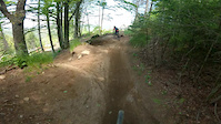
Photos of Grand Est Mountain Bike
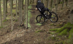
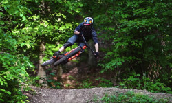
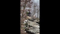
Videos of Grand Est Mountain Bike
trail: La Nuts
0:12 |
125 |
Aug 11, 2024

trail: Liaison Galgen
2:50 |
96 |
Jun 12, 2023
trail: Gouleyante
0:18 |
271 |
Apr 13, 2023
trail: Sicurani
0:41 |
|
Mar 18, 2023
trail: La Rumsteck 2.0
0:14 |
73 |
Mar 20, 2022
trail: La Rumsteck 2.0
0:06 |
33 |
Mar 20, 2022
trail: DH bois Châtel vers Ludres
0:44 |
99 |
Sep 11, 2021
trail: La Roots
0:09 |
100 |
Jun 23, 2021
Current Trail Warnings
| status | trail | date | condition | user | info |
|---|---|---|---|---|---|
| Lac vert Munster | Jun 15, 2026 @ 10:19am (Europe/Paris) Jun 15, 2026 | Ideal | BingoBongo-jjom | Trail ist ab der Wanderweg-Kreuzung... | |
| Le Phanitor Ballon d'Alsace | Jun 8, 2026 @ 7:00pm (Europe/Paris) Jun 8, 2026 | Unknown | jnofear | still signs saying it's closed | |
| La Barbue Bike Park Tournavaux | Jun 2, 2026 @ 1:40pm (Europe/Paris) Jun 2, 2026 | Unknown | jeffieridesmtb | Closed, not maintained nor allowed to... |
Recent Trail Reports
Activity Feed
| username | action | type | title | date |
|---|---|---|---|---|
| Joost010 | wishlist | region | activity #97585174 | Jun 22, 2026 @ 2:24pm 8 hours |
| Panguitch | add | photo | activity #97578107 and 3 more | Jun 22, 2026 @ 12:17pm 10 hours |
| DanielTimo | wishlist | region | activity #97570134 | Jun 22, 2026 @ 10:16am 12 hours |
| DanielTimo | wishlist | region | activity #97570063 | Jun 22, 2026 @ 10:15am 12 hours |
| Mattiasq4OJVz | ridden | trail | activity #97567284 | Jun 22, 2026 @ 9:31am 13 hours |
Recent Comments
| username | type | title | comment | date |
|---|---|---|---|---|
| trail | Trace GPS modifiée | May 3, 2026 @ 11:31pm May 3, 2026 | ||
| trail | la fin est modifié | May 3, 2026 @ 12:14am May 3, 2026 | ||
| trail | Large tree blocking the steep uphill section,... | Apr 30, 2026 @ 9:35am Apr 30, 2026 | ||
| trail | Linked up from above to finish run into the... | Apr 29, 2026 @ 8:04am Apr 29, 2026 | ||
| trail | I accessed this from the hiking trail a bit... | Apr 29, 2026 @ 8:02am Apr 29, 2026 |
Local Badges
-

Epic Mountain Bike Climb 2k1 awarded -

Top 10 Trails0 awarded -
Top 10 Trails0 awarded -
Epic Mountain Bike Climb 2k0 awarded -

Epic Ride 50k52 awarded -
Epic Mountain Bike Climb 2k0 awarded
Bike & Skill Parks
| name | type | city | rating |
|---|---|---|---|
| Lac Blanc Bike Park | bike park | Le Bonhomme | |
| Bikepark La Bresse | bike park | La Bresse | |
| Pumptrack Griesheim | skill park | Griesheim-près-molsheim | |
| Stride - Indoor Bike Park | skill park | Strasbourg | |
| Pumptrack Xertigny | skill park | Xertigny |
Activity Type Stats
| activitytype | trails | distance | descent | descent distance | total vertical | rating | global rank | state rank | photos | reports | routes | ridelogs |
|---|---|---|---|---|---|---|---|---|---|---|---|---|
| Mountain Bike | 1,602 | 1,288 miles | 413,570 ft | 703 miles | 4,209 ft | 1,114 | 2,843 | 103 | 76,900 | |||
| E-Bike | 1,043 | 784 miles | 284,259 ft | 441 miles | 4,012 ft | 6 | 2,375 | 54 | 9,538 | |||
| Gravel Bike | 103 | 146 miles | 10,420 ft | 33 miles | 3,625 ft | 83 | 839 | |||||
| Adaptive Bike | 235 | 298 miles | 17,297 ft | 74 miles | 3,632 ft | 253 | 3 | |||||
| Winter Fat Bike | 17 | 19 miles | 6,680 ft | 12 miles | 2,697 ft | 76 | ||||||
| Horse | 14 | 16 miles | 3,593 ft | 7 miles | 3,294 ft | 352 | 1 | |||||
| Hike | 1,159 | 1,055 miles | 284,790 ft | 534 miles | 4,042 ft | 2,567 | 3 | 5,166 | ||||
| Trail Running | 1,171 | 1,058 miles | 287,178 ft | 536 miles | 4,042 ft | 2,570 | 2 | 1,678 | ||||
| Dirtbike/Moto | 2 | 4,167 ft | 194 ft | 3,445 ft | 636 ft | 346 | 2 | |||||
| Observed Trials | 1 | 3 miles | 121 ft | 3,051 ft | 272 ft | 11 | ||||||
| Downhill Ski | 84 | 31 miles | 27,028 ft | 28 miles | 1,647 ft | 1 | 289 | |||||
| Backcountry Ski | 7 | 7 miles | 3,071 ft | 6 miles | 1,522 ft | 387 | ||||||
| Nordic Ski | 2 | 2 miles | 308 ft | 2 miles | 289 ft | 1 | 652 |
Activities
Trails
Points of Interest
- By hpman83
 TRAILFORKS TFFRANCE & contributors
 - Admins: TFFRANCE, elyari, freerider48, provencemb
- #7543 - 8,112 views
- grand est activity log | embed map of Grand Est mountain bike trails | grand est mountain biking points of interest polygons
Downloading of trail gps tracks in kml & gpx formats is enabled for Grand Est.
You must login to download files.