close
-
Layers w
- Weather Layers
- Pro
- Pro
- Pro
- Pro
- Pro
- Pro
- More Layers
- Pro
- Pro
- Pro
- Pro
-
Upgrade to

3D
Trail Conditions
- Unknown
- Snow Groomed
- Snow Packed
- Snow Covered
- Snow Cover Partial
- Freeze/thaw Cycle
- Icy
- Prevalent Mud
- Wet
- Variable
- Ideal
- Dry
- Very Dry
Trail Flow (Ridden Direction)
Trailforks scans users ridelogs to determine the most popular direction each trail is ridden. A good flowing trail network will have most trails flowing in a single direction according to their intension.
The colour categories are based on what percentage of riders are riding a trail in its intended direction.
The colour categories are based on what percentage of riders are riding a trail in its intended direction.
- > 96%
- > 90%
- > 80%
- > 70%
- > 50%
- < 50%
- bi-directional trail
- no data
Trail Last Ridden
Trailforks scans ridelogs to determine the last time a trail was ridden.
- < 2 days
- < 1 week
- < 2 weeks
- < 1 month
- < 6 months
- > 6 months
Trail Ridden Direction
The intended direction a trail should be ridden.
- Downhill Only
- Downhill Primary
- Both Directions
- Uphill Primary
- Uphill Only
- One Direction
Contribute Details
Colors indicate trail is missing specified detail.
- Description
- Photos
- Description & Photos
- Videos
Trail Popularity ?
Trailforks scans ridelogs to determine which trails are ridden the most in the last 9 months.
Trails are compared with nearby trails in the same city region with a possible 25 colour shades.
Think of this as a heatmap, more rides = more kinetic energy = warmer colors.
- most popular
- popular
- less popular
- not popular
ATV/ORV/OHV Filter
Max Vehicle Width
inches
US Cell Coverage
Legend

Radar Time
Activity Recordings
Trailforks uses anonymized public activity data.
?
Activity Recordings
Trailforks uses anonymized public activity data.
?
Personal Heatmap
▶
Activity Types
all
/
none
▶
Options
2
Date range
month
–
Winter Trails
Warning
A routing network for winter maps does not exist. Selecting trails using the winter trails layer has been disabled.
Missing Trails
Most Popular
Least Popular
Trails are colored based on popularity. The more popular a trail is, the more red. Less popular trails trend towards green.
Jump Magnitude Heatmap
Heatmap of where riders jump on trails. Zoom in to see individual jumps, click circles to view jump details.
BC Backroad Status
![map legend]()
Service Road Atlas is a free to use, community-driven service for viewing and creating reports on the numerous back-country service roads around B.C. and Alberta.

Slope Aspect
Direction the slope faces
Trails Deemphasized
Trails are shown in grey.
Only show trails with no bike usage.
Suggested Layers
Based on selected activity type
Save the current map location and zoom level as your default home location whenever this page is loaded.
Save
No description for Grand Mesa has been added yet!
Login or register to submit one.
 google parking directions
google parking directions Activities Click to view
- Mountain Bike
17 trails
- Hike
18 trails
- Trail Running
18 trails
- Nordic Ski
7 trails
Region Details
- 6
- 4
- 6
- 1
Region Status
Caution as of May 15, 2026Stats
- Avg Trail Rating
- Trails (view details)
- 17
- Trails Mountain Bike
- 17
- Trails E-Bike
- 6
- Trails Gravel Bike
- 2
- Trails Adaptive Bike
- 5
- Trails Horse
- 6
- Trails Hike
- 18
- Trails Trail Running
- 18
- Trails Dirtbike/Moto
- 8
- Trails ATV/ORV/OHV
- 8
- Trails Nordic Ski
- 7
- Total Distance
- 34 miles
- Total Descent
- 4,761 ft
- Total Vertical
- 6,018 ft
- Highest Trailhead
- 10,732 ft
- Reports
- 88
- Photos
- 27
- Ridden Counter
- 4,204
Popular Grand Mesa Mountain Biking Trails
• 85 ★ 4.8 • 4,078 ft • 29 ft • 801 •
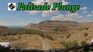
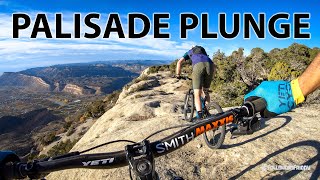
The last section of the Palisade Plunge trail drops into a deep canyon in a fun, technical, wild section of trail. The lower canyon section remains open when the rest of the Palisade Plunge trail is closed for annual wildlife closure...
• 100 ★ 4.1 • 3,907 ft • 363 ft • 651 •
Highly rated popular black diamond difficulty singletrack. This mountain bike primary trail can be used both directions. On average it takes 11 minutes to complete this trail.
• 80 ★ 4.6 • 4 miles • 967 ft • 514 •
Highly rated popular black diamond difficulty singletrack. This mountain bike primary trail can be used both directions. On average it takes 45 minutes to complete this trail.
• 70 ★ 3.5 • 12 miles • 275 ft • 311 •
Topmost section of the full Palisade Plunge route, beginning at Mesa Top TH and ending at Shirttail Pt TH. Mixed open and forested area.
• 90 ★ 0.0 • 2,697 ft • 300 ft • 119 •
Popular black diamond difficulty singletrack. This mountain bike primary trail can be used both directions.
• 60 ★ 3.2 • 4 miles • 1,280 ft • 66 •
Moderately popular black diamond difficulty singletrack. This mountain bike primary trail can be used downhill primary. On average it takes 56 minutes to complete this trail.
• 60 ★ 2.7 • 5 miles • 614 ft • 12 •
trail is actually the gulleys/washes that run parallel and cross over Road. It is VERY fun for exploring, and due to the flooding that can/does happen with heavy rains it is always changing conditions. When I rode it at the end of July...
• 5 ★ 0.0 • 13 miles • 1,461 ft • • atv
Less popular blue difficulty doubletrack. This atv/orv/ohv primary trail can be used both directions.
Grand Mesa Mountain Bike Routes
★ 1.0 • 5 miles • 614 ft • 0 • Out & Back •
Wash/Gulley trail that parallels/crosses the access road multiple time. Very fun, very different...
• 13 miles • 1,804 ft • 9 •
• 6 miles • 1,160 ft • 7 •
• 30 miles • 2,561 ft • 1 •
• 22 miles • 1,820 ft • 4 •
• 22 miles • 1,890 ft • 1 •
Photos of Grand Mesa Mountain Bike
Videos of Grand Mesa Mountain Bike
youtuber
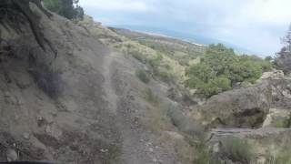
![The Palisade Plunge]()
trail: Palisade Plunge Upper
16:49 |
605 |
Sep 2, 2022 , Palisade
youtuber
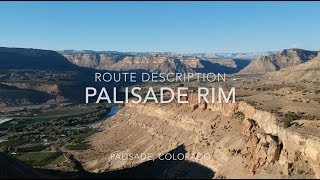
![The Palisade Plunge Experience | Western Slope...]()
11:31 |
683 |
Oct 30, 2021 , Palisade

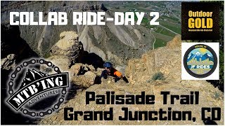
trail: Palisade Rim (upper)
9:05 |
1386 |
Jun 1, 2018 , Palisade
youtuber
![Palisade Rim Trail 2018 (Grand Junction, CO)...]()
trail: Palisade Rim (upper)
10:59 |
698 |
May 21, 2018 , Palisade
trail: Palisade Rim (upper)
14:59 |
907 |
Jan 22, 2018 , Palisade
31:39 |
381 |
Jan 12, 2018
Recent Trail Reports
| status | trail | date | condition | info | user |
|---|---|---|---|---|---|
| Palisade Rim (upper) | May 15, 2026 @ 11:57am (America/Denver) May 15, 2026 | Dry | Jordanb22 | ||
| Palisade Plunge - Upper Canyon | Feb 25, 2026 @ 2:18pm (America/Denver) Feb 25, 2026 | Freeze/thaw Cycle | BCBassett | ||
| Plunge to Rim Connector - Lower | Feb 25, 2026 @ 2:18pm (America/Denver) Feb 25, 2026 | Freeze/thaw Cycle | BCBassett | ||
| Palisade Plunge - Lower Canyon | Sep 30, 2025 @ 9:37am (America/Denver) Sep 30, 2025 | Dry | eLBy Alsea Falls TC | ||
| Palisade Plunge Upper | Jun 25, 2025 @ 8:25am Jun 25, 2025 | Variable | Paranoid006 ASAG | ||
| Coal Canyon - BLM 300 | Jan 11, 2025 @ 2:24pm Jan 11, 2025 | Snow Cover Partial | randyfay | ||
| Palisade Rim Connect | May 2, 2024 @ 11:27am May 2, 2024 | Very Dry | ethanm | ||
| Plunge to Rim Connector - Upper | Jun 11, 2023 @ 3:01am Jun 11, 2023 | Dry | UtahJohn TRAILFORKS | ||
| Stagecoach | Dec 10, 2022 @ 8:47am Dec 10, 2022 | Variable | randyfay |
Activity Feed
| username | action | type | title | date |
|---|---|---|---|---|
| Loulouq | wishlist | trail | activity #96690925 | Jun 10, 2026 @ 12:50pm Jun 10, 2026 |
| PDru4xt | wishlist | trail | activity #96690737 | Jun 10, 2026 @ 12:42pm Jun 10, 2026 |
| mattm254 | add | trail | activity #96452859 and 3 more | Jun 7, 2026 @ 6:11am Jun 7, 2026 |
| mattm254 | add | poi | activity #95977629 and 2 more | May 31, 2026 @ 2:19pm May 31, 2026 |
| mattm254 | add | trail | activity #95977436 | May 31, 2026 @ 2:17pm May 31, 2026 |
Recent Comments
| username | type | title | comment | date |
|---|---|---|---|---|
| trail | Good to do once, but the tread is not fun with... | Jun 27, 2025 @ 7:46am Jun 27, 2025 | ||
| trail | Basically a horseback trail ride on wheels so... | Oct 5, 2023 @ 10:00pm Oct 5, 2023 | ||
| trail | THE TRAIL THAT KEEPS ON GIVING!! Amazing... | Sep 25, 2023 @ 12:07pm Sep 25, 2023 | ||
| trail | This trail has a great personality! | Sep 24, 2023 @ 8:39pm Sep 24, 2023 | ||
| trail | Rode for the first time today. Sick track.... | Jun 24, 2023 @ 8:02pm Jun 24, 2023 |
Nearby Areas
| name | distance | ||||
|---|---|---|---|---|---|
| Gunnison River Bluffs | 4 | 1 | 11.7 km | ||
| Powderhorn Mountain Resort | 6 | 5 | 1 | 11.7 km | |
| Colorado State Park | 11 | 14.4 km | |||
| Kannah Creek Basin | 14.8 km | ||||
| Lunch Loops | 9 | 28 | 18 | 3 | 15 km |
Activity Type Stats
| activitytype | trails | distance | descent | descent distance | total vertical | rating | global rank | state rank | photos | reports | routes | ridelogs |
|---|---|---|---|---|---|---|---|---|---|---|---|---|
| Mountain Bike | 17 | 34 miles | 4,760 ft | 12 miles | 6,017 ft | #4,656 | #1,658 | 27 | 87 | 1 | 1,938 | |
| E-Bike | 6 | 7 miles | 610 ft | 1 mile | 896 ft | 70 | 46 | |||||
| Gravel Bike | 2 | #2,580 | #1,269 | |||||||||
| Adaptive Bike | 5 | #2,595 | #1,275 | |||||||||
| Horse | 6 | 19 miles | 1,749 ft | 7 miles | 5,909 ft | 12 | 1 | |||||
| Hike | 18 | 34 miles | 4,760 ft | 12 miles | 6,017 ft | #5,559 | #1,999 | 87 | 1 | 367 | ||
| Trail Running | 18 | 34 miles | 4,760 ft | 12 miles | 6,017 ft | #4,890 | #1,447 | 87 | 1 | 70 | ||
| Dirtbike/Moto | 8 | 7 miles | 610 ft | 1 mile | 896 ft | 7 | 1 | 1 | ||||
| ATV/ORV/OHV | 8 | 7 miles | 610 ft | 1 mile | 896 ft | 7 | 1 | |||||
| Nordic Ski | 7 | #2,024 | #1,043 |
Frequently Asked Questions About Grand Mesa
▼
What are the highest rated mountain biking trails in Grand Mesa?
The highest rated mountain biking trails in Grand Mesa are:
- Palisade Plunge - Lower Canyon (4.5/5)
- Palisade Rim (upper) (4.4/5)
- Palisade Rim Connect (4.1/5)
- Palisade Plunge Upper (3.7/5)
- Coal Canyon - BLM 300 (3.5/5)
▼
What is the best time of the year to ride in Grand Mesa?
Based on ride log data, the most popular months to ride in Grand Mesa are:
- October (20 activities)
- August (17 activities)
- September (16 activities)
▼
Where can I park to ride in Grand Mesa?
There are 2 parking locations listed in Grand Mesa. The most popular parking spots are:
▼
What is the longest trail in Grand Mesa?
The longest trail in Grand Mesa is Monument Trail at 13.2 miles. View all trails sorted by distance.
Activities
Trails
Points of Interest
- By todd
 Trailforks & contributors
 - Admins: COPMOBA-GVT, COPMOBA-GVT
- #4885 - 10,295 views
- grand mesa activity log | embed map of Grand Mesa mountain bike trails | grand mesa mountain biking points of interest
Downloading of trail gps tracks in kml & gpx formats is enabled for Grand Mesa.
You must login to download files.