close
-
Layers w
- Weather Layers
- Pro
- Pro
- Pro
- Pro
- Pro
- Pro
- More Layers
- Pro
- Pro
- Pro
- Pro
-
Upgrade to

3D
Trail Conditions
- Unknown
- Snow Groomed
- Snow Packed
- Snow Covered
- Snow Cover Partial
- Freeze/thaw Cycle
- Icy
- Prevalent Mud
- Wet
- Variable
- Ideal
- Dry
- Very Dry
Trail Flow (Ridden Direction)
Trailforks scans users ridelogs to determine the most popular direction each trail is ridden. A good flowing trail network will have most trails flowing in a single direction according to their intension.
The colour categories are based on what percentage of riders are riding a trail in its intended direction.
The colour categories are based on what percentage of riders are riding a trail in its intended direction.
- > 96%
- > 90%
- > 80%
- > 70%
- > 50%
- < 50%
- bi-directional trail
- no data
Trail Last Ridden
Trailforks scans ridelogs to determine the last time a trail was ridden.
- < 2 days
- < 1 week
- < 2 weeks
- < 1 month
- < 6 months
- > 6 months
Trail Ridden Direction
The intended direction a trail should be ridden.
- Downhill Only
- Downhill Primary
- Both Directions
- Uphill Primary
- Uphill Only
- One Direction
Contribute Details
Colors indicate trail is missing specified detail.
- Description
- Photos
- Description & Photos
- Videos
Trail Popularity ?
Trailforks scans ridelogs to determine which trails are ridden the most in the last 9 months.
Trails are compared with nearby trails in the same city region with a possible 25 colour shades.
Think of this as a heatmap, more rides = more kinetic energy = warmer colors.
- most popular
- popular
- less popular
- not popular
ATV/ORV/OHV Filter
Max Vehicle Width
inches
US Cell Coverage
Legend

Radar Time
Activity Recordings
Trailforks uses anonymized public activity data.
?
Activity Recordings
Trailforks uses anonymized public activity data.
?
Personal Heatmap
▶
Activity Types
all
/
none
▶
Options
2
Date range
month
–
Winter Trails
Warning
A routing network for winter maps does not exist. Selecting trails using the winter trails layer has been disabled.
Missing Trails
Most Popular
Least Popular
Trails are colored based on popularity. The more popular a trail is, the more red. Less popular trails trend towards green.
Jump Magnitude Heatmap
Heatmap of where riders jump on trails. Zoom in to see individual jumps, click circles to view jump details.
BC Backroad Status
![map legend]()
Service Road Atlas is a free to use, community-driven service for viewing and creating reports on the numerous back-country service roads around B.C. and Alberta.

Slope Aspect
Direction the slope faces
Trails Deemphasized
Trails are shown in grey.
Only show trails with no bike usage.
Suggested Layers
Based on selected activity type
Save the current map location and zoom level as your default home location whenever this page is loaded.
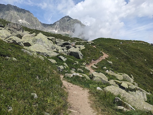
SaveIn Graubünden – the home of trails – almost every path is a bike trail. Experience unforgettable biking holidays with lots of flow and impressive mountain panoramas in Switzerland's largest holiday region.
Links
Files
- Fairtrail-Kodex.pdf (2.10 MB)
This region uses the Uk/Euro style trail grading system.
Region Supporters & Maintainers
![]()
Graubünden TourismSponsor![]()
ITRS Difficulty RatingSponsor
Region Details
- 442
- 294
- 737
- 592
- 241
- 8
Stats
- Avg Trail Rating
- Trails (view details)
- 2,744
- Trails Mountain Bike
- 2,318
- Trails E-Bike
- 2,234
- Trails Gravel Bike
- 336
- Trails Adaptive Bike
- 258
- Trails Hike
- 2,270
- Trails Trail Running
- 2,271
- Trails Snowshoe
- 7
- Trails Downhill Ski
- 282
- Trails Backcountry Ski
- 46
- Trails Nordic Ski
- 29
- Total Distance
- 2,695 miles
- Total Descent
- 1,211,703 ft
- Total Vertical
- 9,503 ft
- Highest Trailhead
- 10,438 ft
- Reports
- 24,886
- Photos
- 5,463
- Ridden Counter
- 289,132
Articles
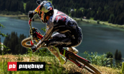
Inside the Tape: Razor-Thin Timing & a Massive Qualifying Shakeup in Lenzerheide
Jun 19, 2026 from pinkbike.com
Ben Cathro and Innes Graham go inside the tape to analyze the new lines, catastrophic crashes, and unexpected top-tier dropouts in Switzerland.

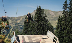
They've Made It Even Faster! | Track Preview - Lenzerheide 2026
Jun 18, 2026 from pinkbike.com
Round 4 of the Downhill World Series shifts to Switzerland, where fresh tunings are sending riders into technical rock gardens with unprecedented...
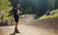
Video: Measuring Lenzerheide’s Biggest World Cup Jumps with a Tape Measure
Jun 17, 2026 from pinkbike.com
Charlie Coquillard takes a tape measure down the high-speed Swiss track to benchmark massive gaps and analyze the brand-new 2026 course sections.
Lenzerheide Celebrates 10 Years of World Cup Madness to Kick Off "Bike Kingdom" Season
Jun 9, 2026 from pinkbike.com
The UCI Mountain Bike World Series returns to Switzerland on June 19–21, bringing elite cross-country and downhill battles alongside a massive...
Popular Trail Networks
view all areas »Sub Regions
- District Albula (252)
- Albula/Alvra (42)
- Bergün Filisur (41)
- Schmitten GR (4)
- Surses (158)
- Val Surses (152)
- Albula/Alvra (42)
- District Bernina (107)
- Poschiavo (107)
- Valposchiavo (104)
- Poschiavo (107)
- District Engiadina Bassa/Val Müstair (307)
- Müstair (130)
- Biosfera Val Müstair (119)
- Samnaun (30)
- Scuol (149)
- Zernez (12)
- Müstair (130)
- District Imboden (110)
- Domat/Ems (109)
- Churer Rheintal (105)
- Domat/Ems (109)
- District Landquart (104)
- District Maloja (275)
- Bregaglia (32)
- La Punt Chamues-ch (11)
- Madulain (7)
- Maloja (1)
- Pontresina (30)
- S-chanf (20)
- Samedan (29)
- Sils im Engadin/Segl (22)
- Silvaplana (25)
- St. Moritz (91)
- Engadin (83)
- zuoz (8)
- Bregaglia (32)
- District Moesa (54)
- Calanca (3)
- Mesocco (17)
- San Bernardino (17)
- Roveredo GR (12)
- San Vittore (14)
- Santa Maria (6)
- Soazza (3)
- Calanca (3)
- District Plessur (323)
- Arosa Lenzerheide (209)
- Bike Kingdom (163)
- Bike Kingdom Park (7)
- Chur (118)
- Alpen Bikepark (8)
- Fürstenwald (27)
- Mittenberg (39)
- Arosa Lenzerheide (209)
- District Prättigau/Davos (295)
- Davos (206)
- Davos Klosters (206)
- Furna (7)
- Grüsch (17)
- Jenaz (1)
- Luzein (32)
- Sankt Antönien (20)
- Schiers (20)
- Seewis Im Prättigau (21)
- Davos (206)
- District Surselva (409)
- Breil/Brigels (28)
- Disentis Sedrun (111)
- Rheinquelle Region (111)
- Flims LAAX (108)
- Ilanz/Glion (33)
- Lumnezia (28)
- Obersaxen Mundaun (31)
- Safiental (26)
- Sumvitg (30)
- Trun (14)
- Vals (5)
- Breil/Brigels (28)
- District Viamala (164)
- Rhäzüns (1)
Popular Graubünden Mountain Biking Trails
• 90 ★ 4.9 • 4,081 ft • 0 ft • 1,911 •
Highly rated popular blue difficulty singletrack. This multi-use trail can be used downhill primary and has a easy overall physical rating with a 0 ft green climb. Trail visibility is always easy to follow. On average it takes minutes to complete this trail.
• 70 ★ 4.7 • 5 miles • 825 ft • 1,641 •
Vom Strelapass führt ein schöner Singletrail weiter über die Latschüelfurgga zur Chörbschhornhütte. Wer noch nicht genug hat steigt zu Fuss hoch zum Chörbschhorngipfel. Von der Chörbschhornhütte folgt das Highlight des Trails....
• 45 ★ 4.3 • 1 mile • 0 ft • 1,508 •
Anspruchsvolle, weltcuptaugliche Downhillstrecke im steilen Gelände mit grossen Sprüngen, Drops, Anlegern und North Shore Elementen.
• 100 ★ 4.0 • 3,622 ft • 0 ft • 1,362 •
Popular red difficulty singletrack. This mountain bike primary trail can be used downhill only. On average it takes 4 minutes to complete this trail.
• 100 ★ 4.7 • 3 miles • 3 ft • 1,307 •
Die Strecke wurde 2015 von der Trail Crew saniert. Dies ist der erste Teil des Alps Epic Trail Davos. Der Startpunkt kann bequem mit der erreicht werden. Bitte aus Rücksicht auf unsere Wildtiere diesen Trail zwischen 18:30 und 08:00...
Graubünden Mountain Bike Routes
Alps Epic Trail Davos (IMBA Epic) Featured
★ 4.4 • 24 miles • 2,601 ft • 13 • Point to Point •
: This ride features stunning views of the Alps with biergartens along the way.The majority of the route...
Passo del Gallo - Val Mora Featured
★ 5.0 • 23 miles • 2,745 ft • 14 • Loop •
An extension of the classic tour "Val Mora - A Feeling of Canadian Wilderness", for those who are looking...
Val Müstair Bike #449 Featured
★ 5.0 • 13 miles • 1,263 ft • 16 • Shuttled •
Es gibt keinen besseren Weg, um das Val Müstair kennenzulernen. Die Tour führt über 21 km und 1000...
Rinerhorn / Sertig #647 Featured
★ 5.0 • 20 miles • 3,243 ft • 10 • Loop •
Paved: 13km Forest Track: 11km SingleTrail: 9km
Trail Tales #18 Fürhörnli Featured
★ 5.0 • 21 miles • 6,037 ft • 20 • Point to Point •
We will start our tour this morning in Parpan, gently beginning our ascent on asphalt roads until we reach...
Best of Disentis Sedrun Featured
34 miles • 9,088 ft • 26 • Shuttled •
In we start the tour, over the panoramic mountain , to the train station Sedrun. The train now takes us to...
Photos of Graubünden Mountain Bike
Videos of Graubünden Mountain Bike
trail: Tomilser lll
0:52 |
6 |
May 28, 2026
trail: Dirauls
0:31 |
6 |
May 28, 2026
trail: Mozentobel
2:58 |
11 |
Apr 27, 2026
trail: Dieba Cliffside
0:23 |
11 |
Apr 27, 2026
trail: Val Tschitta
9:57 |
16 |
Apr 15, 2026
trail: Richtplatz
0:19 |
9 |
Mar 23, 2026
trail: Dieba Cliffside
0:46 |
6 |
Feb 27, 2026
trail: Murtèl to Sils
0:28 |
8 |
Sep 30, 2025
Current Trail Warnings
| status | trail | date | condition | user | info |
|---|---|---|---|---|---|
| Plauncas Cuflegl Rheinquelle Region | Jun 14, 2026 @ 10:54am (Europe/Zurich) Jun 14, 2026 | Ideal | retosedrun | E-Bike | |
| Schlüechtli Bike Kingdom | Jun 10, 2026 @ 10:16am (Europe/Zurich) Jun 10, 2026 | Unknown | trailpapst TRAILFORKS | ||
| Paschget II Bikespot Viamala | Jun 10, 2026 @ 11:03pm (Europe/Zurich) Jun 10, 2026 | Dry | trailpapst TRAILFORKS | blocked access |
Recent Trail Reports
| status | trail | date | condition | info | user |
|---|---|---|---|---|---|
| Gotschna Freeride Davos Klosters | Jun 20, 2026 @ 4:40pm (Europe/Zurich) 3 hours | Ideal | gejemia | ||
| Geissegga Davos Klosters | Jun 20, 2026 @ 4:39pm (Europe/Zurich) 3 hours | Ideal | gejemia | ||
| Arensa - Saas Davos Klosters | Jun 20, 2026 @ 4:39pm (Europe/Zurich) 3 hours | Ideal | gejemia | ||
| Sagenturm Madrisa - Arensa Davos Klosters | Jun 20, 2026 @ 4:39pm (Europe/Zurich) 3 hours | Ideal | gejemia | ||
| Stoffaburg Schiers | Jun 20, 2026 @ 3:33pm (Europe/Zurich) 4 hours | Ideal | SummerSon | ||
| Lai da Ravais-ch Bergün Filisur | Jun 20, 2026 @ 9:45am (Europe/Zurich) 10 hours | Snow Packed | jacksowieso | ||
| Sertigpass South S-chanf | Jun 20, 2026 @ 9:44am (Europe/Zurich) 10 hours | Snow Packed | jacksowieso | ||
| Sertigpass North Davos Klosters | Jun 20, 2026 @ 9:43am (Europe/Zurich) 10 hours | Snow Packed | jacksowieso | ||
| Ducanfurgga Top Bergün Filisur | Jun 20, 2026 @ 9:42am (Europe/Zurich) 10 hours | Ideal | jacksowieso | ||
| Ducanfurgga Trail Bergün Filisur | Jun 20, 2026 @ 9:41am (Europe/Zurich) 10 hours | Ideal | jacksowieso |
National Scenic Trails & Official Routes
-
St.-Gotthard Fünf-Pässe Bike #85
- Mountain Bike
- E-Bike
-
St.-Gotthard Vier-Pässe Bike #84
- Mountain Bike
- E-Bike
-
Trans-Altarezia Bike #32
- Mountain Bike
- E-Bike

Activity Feed
| username | action | type | title | date |
|---|---|---|---|---|
| gejemia | add | report | activity #97393847 and 3 more | Jun 20, 2026 @ 7:39am 3 hours |
| SummerSon | ridden | trail | activity #97390223 | Jun 20, 2026 @ 6:55am 3 hours |
| SummerSon | vote | trail | activity #97390200 | Jun 20, 2026 @ 6:55am 3 hours |
| SummerSon | vote | trail | activity #97388852 | Jun 20, 2026 @ 6:36am 4 hours |
| SummerSon | ridden | trail | activity #97388686 | Jun 20, 2026 @ 6:34am 4 hours |
Recent Comments
| username | type | title | comment | date |
|---|---|---|---|---|
| trail | Nice that it is possible to build a new trail... | Jun 19, 2026 @ 3:52am 1 day | ||
| report | Trail Closed due to forest working | Jun 17, 2026 @ 12:50am Jun 17, 2026 | ||
| trail | Landschaftlich sehr schöner Trail mit... | Jun 17, 2026 @ 12:41am Jun 17, 2026 | ||
| trail | Landschaftlich sehr schöner Trail mit... | Jun 17, 2026 @ 12:40am Jun 17, 2026 | ||
| trail | I believe the pictures and the comment of the... | Jun 8, 2026 @ 12:45pm Jun 8, 2026 |
Local Badges
-
10 Red Trails30 awarded -

JUST RIDE 2025 - Day 14 awarded -

10 Black Trails28 awarded -
10 Blue Trails0 awarded -
JUST RIDE 2025 - Day 36 awarded -
JUST RIDE 2025 - Day 25 awarded
Bike & Skill Parks
| name | type | city | rating |
|---|---|---|---|
| Biketrails Flims Laax | bike park | Flims LAAX | |
| Bike Kingdom Park | bike park | Arosa Lenzerheide | |
| Alpen Bikepark | bike park | Chur | |
| Adventure Park Davos Färich | skill park | Davos | |
| PALÜDS Center da Trail | skill park | Scuol |
Upcoming Local Events
-
-
-
-
Local Trail Supporters
![IMBA Epic]()
- Trailuniun
![]()
![]()
![Shimano]()
Local Trail Supporters
![IMBA Epic]()
- Trailuniun
![]()
![]()
![Shimano]()
Activity Type Stats
| activitytype | trails | distance | descent | descent distance | total vertical | rating | global rank | state rank | photos | reports | routes | ridelogs |
|---|---|---|---|---|---|---|---|---|---|---|---|---|
| Mountain Bike | 2,317 | 2,245 miles | 951,663 ft | 1,319 miles | 8,967 ft | 5,398 | 24,785 | 120 | 78,600 | |||
| E-Bike | 2,234 | 2,153 miles | 887,011 ft | 1,247 miles | 8,967 ft | 44 | 23,714 | 103 | 11,013 | |||
| Gravel Bike | 336 | 161 miles | 20,141 ft | 43 miles | 7,139 ft | 1,506 | 2 | 498 | ||||
| Adaptive Bike | 258 | 243 miles | 32,585 ft | 74 miles | 7,444 ft | 2,706 | 2 | 7 | ||||
| Hike | 2,269 | 2,235 miles | 942,306 ft | 1,299 miles | 9,278 ft | 6 | 23,863 | 23 | 10,369 | |||
| Trail Running | 2,271 | 2,237 miles | 943,379 ft | 1,301 miles | 9,278 ft | 23,860 | 21 | 3,089 | ||||
| Snowshoe | 7 | 19 miles | 5,725 ft | 9 miles | 3,684 ft | 730 | 310 | |||||
| Downhill Ski | 282 | 208 miles | 180,942 ft | 204 miles | 6,138 ft | 823 | 15,027 | |||||
| Backcountry Ski | 46 | 104 miles | 24,688 ft | 22 miles | 5,988 ft | 820 | 6,853 | |||||
| Nordic Ski | 29 | 44 miles | 3,671 ft | 21 miles | 5,016 ft | 723 | 9,820 |
Activities
- Graubünden Mountain Biking Trails
- Graubünden E-Biking Trails
- Graubünden Gravel Biking Trails
- Graubünden Adaptive Biking Trails
- Graubünden Hiking Trails
- Graubünden Trail Running Trails
- Graubünden Snowshoeing Trails
- Graubünden Skiing Trails
- Graubünden Backcountry Skiing Trails
- Graubünden Nordic Skiing Trails
Trails
Points of Interest
- St. Luzi Chapel Sight
- Berghaus Vereina Lodge
- Piz Pazzola 2581m Summit
- Dreibündenstein Sight
- Lai Da Tuma Sight
- Lag Da Claus Sight
- Camona da Maighels CAS Lodge
- Bifertenhütte Lodge
- Stellplatz am Heimbergparkplatz Camping
- Stellplatz Fadail Parkplatz Camping
- Piz Bernina (3,922 m)
- Pizzo Bianco (3,903 m)
- La Spedla (3,881 m)
- By brenthillier
 NSMBA TRAILFORKS & contributors
 - Admins: swiss, trailpapst
- #8965 - 17,375 views
- graubünden activity log | embed map of Graubünden mountain bike trails | graubünden mountain biking points of interest polygons
Downloading of trail gps tracks in kml & gpx formats is enabled for Graubünden.
You must login to download files.