close
-
Layers w
- Weather Layers
- Pro
- Pro
- Pro
- Pro
- Pro
- Pro
- More Layers
- Pro
- Pro
- Pro
- Pro
-
Upgrade to

3D
Trail Conditions
- Unknown
- Snow Groomed
- Snow Packed
- Snow Covered
- Snow Cover Partial
- Freeze/thaw Cycle
- Icy
- Prevalent Mud
- Wet
- Variable
- Ideal
- Dry
- Very Dry
Trail Flow (Ridden Direction)
Trailforks scans users ridelogs to determine the most popular direction each trail is ridden. A good flowing trail network will have most trails flowing in a single direction according to their intension.
The colour categories are based on what percentage of riders are riding a trail in its intended direction.
The colour categories are based on what percentage of riders are riding a trail in its intended direction.
- > 96%
- > 90%
- > 80%
- > 70%
- > 50%
- < 50%
- bi-directional trail
- no data
Trail Last Ridden
Trailforks scans ridelogs to determine the last time a trail was ridden.
- < 2 days
- < 1 week
- < 2 weeks
- < 1 month
- < 6 months
- > 6 months
Trail Ridden Direction
The intended direction a trail should be ridden.
- Downhill Only
- Downhill Primary
- Both Directions
- Uphill Primary
- Uphill Only
- One Direction
Contribute Details
Colors indicate trail is missing specified detail.
- Description
- Photos
- Description & Photos
- Videos
Trail Popularity ?
Trailforks scans ridelogs to determine which trails are ridden the most in the last 9 months.
Trails are compared with nearby trails in the same city region with a possible 25 colour shades.
Think of this as a heatmap, more rides = more kinetic energy = warmer colors.
- most popular
- popular
- less popular
- not popular
ATV/ORV/OHV Filter
Max Vehicle Width
inches
US Cell Coverage
Legend

Radar Time
Activity Recordings
Trailforks uses anonymized public activity data.
?
Activity Recordings
Trailforks uses anonymized public activity data.
?
Personal Heatmap
▶
Activity Types
all
/
none
▶
Options
2
Date range
month
–
Winter Trails
Warning
A routing network for winter maps does not exist. Selecting trails using the winter trails layer has been disabled.
Missing Trails
Most Popular
Least Popular
Trails are colored based on popularity. The more popular a trail is, the more red. Less popular trails trend towards green.
Jump Magnitude Heatmap
Heatmap of where riders jump on trails. Zoom in to see individual jumps, click circles to view jump details.
BC Backroad Status
![map legend]()
Service Road Atlas is a free to use, community-driven service for viewing and creating reports on the numerous back-country service roads around B.C. and Alberta.

Slope Aspect
Direction the slope faces
Trails Deemphasized
Trails are shown in grey.
Only show trails with no bike usage.
Suggested Layers
Based on selected activity type
Save the current map location and zoom level as your default home location whenever this page is loaded.
Save
No description for Grenoble has been added yet!
Login or register to submit one.
This region uses the Uk/Euro style trail grading system.
Activities Click to view
- Mountain Bike
138 trails
- E-Bike
127 trails
- Adaptive Bike
0 trails
- Horse
7 trails
- Hike
94 trails
- Trail Running
95 trails
- Dirtbike/Moto
4 trails
- Observed Trials
4 trails
- ATV/ORV/OHV
4 trails
Region Details
- 32
- 7
- 28
- 33
- 23
Region Status
Open as of Jun 13, 2026Stats
- Avg Trail Rating
- Trails (view details)
- 123
- Trails Mountain Bike
- 139
- Trails E-Bike
- 127
- Trails Horse
- 7
- Trails Hike
- 95
- Trails Trail Running
- 95
- Trails Dirtbike/Moto
- 4
- Trails Observed Trials
- 4
- Trails ATV/ORV/OHV
- 4
- Total Distance
- 78 miles
- Total Descent
- 38,197 ft
- Total Vertical
- 3,931 ft
- Highest Trailhead
- 4,521 ft
- Reports
- 1,207
- Photos
- 140
- Ridden Counter
- 7,503
Sub Regions
-
Les 4 Seigneurs
- 2
- 12
- 11
- 12
-
Mont Rachais
- 2
- 2
- 9
- 5
- 1
-
Rocher de Comboire
- 3
- 9
- 4
- 2
Popular Grenoble Mountain Biking Trails
• 85 ★ 4.0 • 2,477 ft • 0 ft • 71 •
Highly rated popular red difficulty singletrack. This mountain bike primary trail can be used downhill only and has a moderate overall physical rating. It features jump. Trail visibility is always easy to follow. On average it takes 21 minutes to complete this trail.
• 90 ★ 4.0 • 1 mile • 64 ft • 64 • • hike
A classical with high variety of terrain (single, small rock garden ...), funny but have to be ride carefully (especially on weekend) as it's a GR (grande randonnée) and there is a lot of people / trailer in it who have priority.
• 100 ★ 4.9 • 2,762 ft • 3 ft • 64 •
Trail avec pas mal de flow, ca commence par une liaison avec une petite relance, puis ca tourne sur la droite pour aller dans la pente avec des grand virages rapides, quelques saut s'y cache aussi. S'en suit des sections alternant entre...
• 90 ★ 4.0 • 1,214 ft • 86 ft • 58 • • hike
Easy trail which makes for a fun singletrack climb.
• 95 ★ 4.8 • 1,690 ft • 0 ft • 53 •
Trail plutot enduro. Ca commence par une section droite dans un champs puis un ancien chemin pour ensuite tomber sur la droite et devenir le trail. C'est sinueux avec pas mal de flow, quelques devers avec des racines. EN : More of an...
• 90 ★ 3.8 • 1,877 ft • 6 ft • 44 •
Trail plutôt enduro assez étroit et naturel sur la crête avec des deux petites relances. Dans de la bonne terre et quelques racines. Rather enduro trail, fairly narrow and natural on the ridge with two short restarts. In good soil...
• 95 ★ 3.8 • 1 mile • 31 ft • 43 • • hike
Can't beat a classic ! This is the most known trail in Grenoble. A lot of switchbacks (22 in total from top to bottom), some harder than others. Can be judged as more than difficult/red by many riders as there are parts where you should...
• 75 ★ 4.0 • 3,084 ft • 74 ft • 42 • • hike
Popular red difficulty singletrack. This hike primary trail can be used downhill primary and has a moderate overall physical rating. On average it takes 3 minutes to complete this trail.
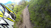
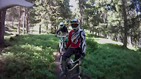
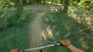
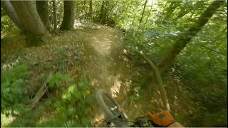
Photos of Grenoble Mountain Bike
Videos of Grenoble Mountain Bike
trail: Rachais
5:25 |
583 |
May 9, 2014
trail: Cimentiers
6:11 |
360 |
Jul 22, 2013
trail: Moldav
4:59 |
84 |
Sep 13, 2025 , Grenoble
trail: La Cov' Lower
4:38 |
57 |
Sep 13, 2025 , Grenoble

trail: La Cov'
4:38 |
81 |
Sep 13, 2025 , Grenoble

trail: La Classique
141 |
Jun 18, 2025 , Grenoble
trail: La Moelleuse
81 |
Jun 18, 2025 , Grenoble

trail: La Fournée
61 |
Jun 18, 2025 , Grenoble
Current Trail Warnings
| status | trail | date | condition | user | info |
|---|---|---|---|---|---|
| Fournet Lower | Jun 14, 2026 @ 8:50am (Europe/Monaco) Jun 13, 2026 | Dry | jjdj |
Recent Trail Reports
| status | trail | date | condition | info | user |
|---|---|---|---|---|---|
| Camp de Poisat | Jun 14, 2026 @ 8:50am (Europe/Monaco) Jun 13, 2026 | Dry | jjdj | ||
| Liaison Camp de poisat | Jun 14, 2026 @ 8:50am (Europe/Monaco) Jun 13, 2026 | Ideal | jjdj | ||
| La Classique | Jun 14, 2026 @ 8:50am (Europe/Monaco) Jun 13, 2026 | Ideal | jjdj | ||
| Fournet | Jun 14, 2026 @ 8:50am (Europe/Monaco) Jun 13, 2026 | Ideal | jjdj | ||
| Lachard | Jun 13, 2026 @ 2:34pm (Europe/Paris) Jun 13, 2026 | Ideal | QuentinskPEoS | ||
| La Voie du Tram | Jun 6, 2026 @ 10:48am (Europe/Monaco) Jun 6, 2026 | Ideal | gottferdom | ||
| Voie du Tram Part3 | Jun 6, 2026 @ 10:48am (Europe/Monaco) Jun 6, 2026 | Ideal | gottferdom | ||
| Montée Vouillants | Jun 6, 2026 @ 10:48am (Europe/Monaco) Jun 6, 2026 | Ideal | gottferdom | ||
| Mur de Karl Marx | Jun 6, 2026 @ 10:48am (Europe/Monaco) Jun 6, 2026 | Ideal | gottferdom | ||
| Frettes | Jun 3, 2026 @ 6:59pm (Europe/Monaco) Jun 3, 2026 | Ideal | AppleNick |
Activity Feed
| username | action | type | title | date |
|---|---|---|---|---|
| paco-jones | add | photo | activity #97380563 | Jun 20, 2026 @ 4:20am 2 days |
| jjdj | add | report | activity #96971339 and 4 more | Jun 14, 2026 @ 8:21am Jun 14, 2026 |
| QuentinskPEoS | add | report | activity #96865959 | Jun 13, 2026 @ 5:34am Jun 13, 2026 |
| gottferdom | add | report | activity #96494822 and 3 more | Jun 7, 2026 @ 1:47pm Jun 7, 2026 |
| AppleNick | add | report | activity #96208095 and 5 more | Jun 3, 2026 @ 11:25pm Jun 3, 2026 |
Recent Comments
| username | type | title | comment | date |
|---|---|---|---|---|
| report | Top, merci 😊 | May 27, 2026 @ 11:13pm May 27, 2026 | ||
| report | Yep, ça commence à être limite trop... | Apr 9, 2026 @ 12:49pm Apr 9, 2026 | ||
| report | Au top le reshape ! Notamment le gauche en... | Apr 2, 2026 @ 8:01am Apr 2, 2026 | ||
| trail | Trop bon ! | Mar 8, 2026 @ 10:39am Mar 8, 2026 | ||
| report | 👍 merci ! 🙏 | Mar 8, 2026 @ 1:42am Mar 8, 2026 |
Local Badges
-

Epic Ride Climb 2k285 awarded -

Climbing 10k Badge88 awarded -

Climbing 100k Badge13 awarded -

Epic Ride Descent 2k310 awarded -

Descent 10k Badge93 awarded -

Descent 100k Badge14 awarded
Bike & Skill Parks
| name | type | city | rating |
|---|---|---|---|
| PUMPTRACK VIF | skill park | Grenoble | |
| BMX Race Track | skill park | Grenoble | |
| Pumptrack de Gières | skill park | Grenoble |
Local Mountain Biking Directory
-
Vtt FreerideBike Shop
-
Takamaka GrenobleBike Shop
-
Takamaka.grenobleBike Shop
Activity Type Stats
| activitytype | trails | distance | descent | descent distance | total vertical | rating | global rank | state rank | photos | reports | routes | ridelogs |
|---|---|---|---|---|---|---|---|---|---|---|---|---|
| Mountain Bike | 138 | 78 miles | 38,196 ft | 45 miles | 3,930 ft | #1,231 | #23 | 140 | 1,207 | 13,199 | ||
| E-Bike | 127 | 73 miles | 35,217 ft | 42 miles | 3,930 ft | #757 | #62 | 1,139 | 1,234 | |||
| Horse | 7 | 4 miles | 207 ft | 3,839 ft | 2,444 ft | #463 | #26 | 141 | ||||
| Hike | 94 | 68 miles | 25,801 ft | 36 miles | 3,799 ft | #1,300 | #31 | 1,032 | 343 | |||
| Trail Running | 95 | 68 miles | 25,801 ft | 36 miles | 3,799 ft | #1,028 | #28 | 1,032 | 1,350 | |||
| Dirtbike/Moto | 4 | 3 miles | 194 ft | 3,543 ft | 2,129 ft | #371 | #13 | 141 | 1 | |||
| Observed Trials | 4 | 3 miles | 194 ft | 3,543 ft | 2,129 ft | #94 | #13 | |||||
| ATV/ORV/OHV | 4 | 3 miles | 194 ft | 3,543 ft | 2,129 ft | #246 | #12 | 141 |
Frequently Asked Questions About Grenoble
▼
What are the best places to ride in Grenoble?
Grenoble has 3 areas to explore for mountain biking. The top rated areas are:
▼
What are the highest rated mountain biking trails in Grenoble?
The highest rated mountain biking trails in Grenoble are:
- La Classique (4.4/5)
- Keupon Lower (4.4/5)
- Snake (4.3/5)
- La Moelleuse (4.3/5)
- DH Chantemerle (4.3/5)
▼
What is the best time of the year to ride in Grenoble?
Based on ride log data, the most popular months to ride in Grenoble are:
- March (47 activities)
- October (44 activities)
- February (34 activities)
▼
Where can I park to ride in Grenoble?
There are 8 parking locations listed in Grenoble. The most popular parking spots are: View all parking and trailhead locations on the map to plan your visit.
Activities
Trails
- By anyexcusetoride & contributors
- Admins: B MTB Co, JordiBN, Whipperman
- #11775 - 24,181 views
- grenoble activity log | embed map of Grenoble mountain bike trails | grenoble mountain biking points of interest
Downloading of trail gps tracks in kml & gpx formats is enabled for Grenoble.
You must login to download files.