close
-
Layers w
- Weather Layers
- Pro
- Pro
- Pro
- Pro
- Pro
- Pro
- More Layers
- Pro
- Pro
- Pro
- Pro
-
Upgrade to

3D
Trail Conditions
- Unknown
- Snow Groomed
- Snow Packed
- Snow Covered
- Snow Cover Partial
- Freeze/thaw Cycle
- Icy
- Prevalent Mud
- Wet
- Variable
- Ideal
- Dry
- Very Dry
Trail Flow (Ridden Direction)
Trailforks scans users ridelogs to determine the most popular direction each trail is ridden. A good flowing trail network will have most trails flowing in a single direction according to their intension.
The colour categories are based on what percentage of riders are riding a trail in its intended direction.
The colour categories are based on what percentage of riders are riding a trail in its intended direction.
- > 96%
- > 90%
- > 80%
- > 70%
- > 50%
- < 50%
- bi-directional trail
- no data
Trail Last Ridden
Trailforks scans ridelogs to determine the last time a trail was ridden.
- < 2 days
- < 1 week
- < 2 weeks
- < 1 month
- < 6 months
- > 6 months
Trail Ridden Direction
The intended direction a trail should be ridden.
- Downhill Only
- Downhill Primary
- Both Directions
- Uphill Primary
- Uphill Only
- One Direction
Contribute Details
Colors indicate trail is missing specified detail.
- Description
- Photos
- Description & Photos
- Videos
Trail Popularity ?
Trailforks scans ridelogs to determine which trails are ridden the most in the last 9 months.
Trails are compared with nearby trails in the same city region with a possible 25 colour shades.
Think of this as a heatmap, more rides = more kinetic energy = warmer colors.
- most popular
- popular
- less popular
- not popular
ATV/ORV/OHV Filter
Max Vehicle Width
inches
US Cell Coverage
Legend

Radar Time
Activity Recordings
Trailforks uses anonymized public activity data.
?
Activity Recordings
Trailforks uses anonymized public activity data.
?
Personal Heatmap
▶
Activity Types
all
/
none
▶
Options
2
Date range
month
–
Winter Trails
Warning
A routing network for winter maps does not exist. Selecting trails using the winter trails layer has been disabled.
Missing Trails
Most Popular
Least Popular
Trails are colored based on popularity. The more popular a trail is, the more red. Less popular trails trend towards green.
Jump Magnitude Heatmap
Heatmap of where riders jump on trails. Zoom in to see individual jumps, click circles to view jump details.
BC Backroad Status
![map legend]()
Service Road Atlas is a free to use, community-driven service for viewing and creating reports on the numerous back-country service roads around B.C. and Alberta.

Slope Aspect
Direction the slope faces
Trails Deemphasized
Trails are shown in grey.
Only show trails with no bike usage.
Suggested Layers
Based on selected activity type
Save the current map location and zoom level as your default home location whenever this page is loaded.
SaveGrevena is the capital of Grevena prefecture
Activities Click to view
- Mountain Bike
14 trails
- E-Bike
9 trails
- Gravel Bike
0 trails
- Adaptive Bike
0 trails
- Winter Fat Bike
0 trails
- Hike
7 trails
- Trail Running
7 trails
Region Details
- 3
- 5
- 4
- 1
Region Status
Caution as of May 9, 2026Stats
- Avg Trail Rating
- Trails (view details)
- 13
- Trails Mountain Bike
- 14
- Trails E-Bike
- 9
- Trails Hike
- 7
- Trails Trail Running
- 7
- Total Distance
- 5 miles
- Total Descent
- 3,889 ft
- Total Vertical
- 5,095 ft
- Highest Trailhead
- 6,850 ft
- Reports
- 19
- Photos
- 44
- Ridden Counter
- 39
Sub Regions
-
Vasilitsa
- 2
- 2
- 1
Popular Grevena Mountain Biking Trails
• 5 ★ 0.0 • 1,716 ft • 0 ft • 3 •
The title '' '' comes from the fact that it's quite technical, not that steep and full of continuous corners! Because of that, there is no place that you can speed up more than 30-35 km/h. Great trail for mostly every type of mountain bike.
• 5 ★ 5.0 • 5,069 ft • 2 ft • 2 •
Less popular blue difficulty singletrack. This mountain bike primary trail can be used both directions.
• 5 ★ 0.0 • 1 mile • 0 ft • 2 •
Less popular green difficulty singletrack. This mountain bike primary trail can be used both directions. On average it takes 3 minutes to complete this trail.
• 5 ★ 0.0 • 4,193 ft • 32 ft • 1 •
Less popular green difficulty family friendly singletrack. This multi-use trail can be used both directions and has a easy overall physical rating with a 32 ft green climb. Trail visibility is always easy to follow.
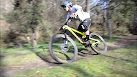
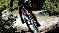
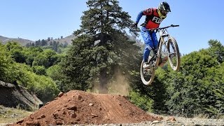
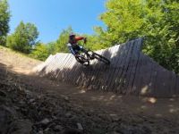
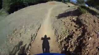
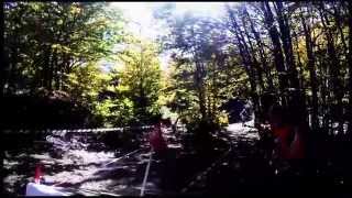
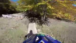
Photos of Grevena Mountain Bike
Videos of Grevena Mountain Bike
trail: Slow Trail
0:26 |
143 |
Feb 15, 2016
trail: Slow Trail
0:47 |
142 |
Jul 13, 2014
trail: Mini DH
805 |
Sep 22, 2015 , Grevena
trail: Mini DH
658 |
Sep 14, 2015 , Grevena
trail: Mini DH
530 |
Sep 14, 2015 , Grevena

trail: Mini DH
604 |
Sep 7, 2015 , Grevena
trail: Blue 1
614 |
Oct 27, 2014 , Grevena
trail: Blue 1
634 |
Oct 13, 2014 , Grevena
Recent Trail Reports
| status | trail | date | condition | info | user |
|---|---|---|---|---|---|
| Slow Trail | Nov 17, 2024 @ 12:26pm Nov 17, 2024 | Variable | danisk | ||
| Blue 1 | Jun 13, 2015 @ 11:04am Jun 13, 2015 | Wet | ioannismarinos |
Activity Feed
| username | action | type | title | date |
|---|---|---|---|---|
| konstantinoskaraiskos | add | photo | activity #97970420 and 2 more | Jun 28, 2026 @ 2:31am 4 hours |
| danisk | add | trail | activity #65835544 | Feb 7, 2025 @ 10:24am Feb 7, 2025 |
| danisk | add | trail | activity #64103144 and 1 more | Jan 5, 2025 @ 2:24am Jan 5, 2025 |
| danisk | add | trail | activity #63170531 and 1 more | Dec 15, 2024 @ 11:49am Dec 15, 2024 |
| danisk | add | trail | activity #63013594 and 1 more | Dec 12, 2024 @ 6:11am Dec 12, 2024 |
Local Badges
-

Epic Mountain Bike Climb 2k2 awarded -

Climbing 10k Badge0 awarded -

Mountain Biking 100k Badge0 awarded -

Epic Ride Descent 2k2 awarded -

Descent 10k Badge0 awarded -

Descent 100k Badge0 awarded
Activity Type Stats
| activitytype | trails | distance | descent | descent distance | total vertical | rating | global rank | state rank | photos | reports | routes | ridelogs |
|---|---|---|---|---|---|---|---|---|---|---|---|---|
| Mountain Bike | 14 | 5 miles | 3,888 ft | 4 miles | 5,095 ft | #3,034 | #25 | 44 | 19 | 103 | ||
| E-Bike | 9 | 2 miles | 2,224 ft | 2 miles | 1,201 ft | #2,370 | #26 | 18 | 4 | |||
| Hike | 7 | 4 miles | 3,081 ft | 3 miles | 1,447 ft | #4,136 | #36 | 18 | 70 | |||
| Trail Running | 7 | 4 miles | 3,081 ft | 3 miles | 1,447 ft | #3,574 | #37 | 18 | 2 |
Frequently Asked Questions About Grevena
▼
What are the best places to ride in Grevena?
Grevena has 1 areas to explore for mountain biking. The top rated areas are:
▼
What are the highest rated mountain biking trails in Grevena?
The highest rated mountain biking trails in Grevena are:
- Blue 1 (4.4/5)
- Vasilitsa-DH Track (4.2/5)
- Mini DH (4.2/5)
- peripheral (4/5)
- Slow Trail (0/5)
▼
What is the best time of the year to ride in Grevena?
Based on ride log data, the most popular months to ride in Grevena are:
- October (3 activities)
- August (2 activities)
- June (1 activities)
▼
Where can I park to ride in Grevena?
Activities
Trails
Points of Interest
- By ioannismarinos & contributors
- Admins: apply
- #4224 - 2,646 views
- grevena activity log | embed map of Grevena mountain bike trails | grevena mountain biking points of interest
Downloading of trail gps tracks in kml & gpx formats is enabled for Grevena.
You must login to download files.