close
-
Layers w
- Weather Layers
- Pro
- Pro
- Pro
- Pro
- Pro
- Pro
- More Layers
- Pro
- Pro
- Pro
- Pro
-
Upgrade to

3D
Trail Conditions
- Unknown
- Snow Groomed
- Snow Packed
- Snow Covered
- Snow Cover Partial
- Freeze/thaw Cycle
- Icy
- Prevalent Mud
- Wet
- Variable
- Ideal
- Dry
- Very Dry
Trail Flow (Ridden Direction)
Trailforks scans users ridelogs to determine the most popular direction each trail is ridden. A good flowing trail network will have most trails flowing in a single direction according to their intension.
The colour categories are based on what percentage of riders are riding a trail in its intended direction.
The colour categories are based on what percentage of riders are riding a trail in its intended direction.
- > 96%
- > 90%
- > 80%
- > 70%
- > 50%
- < 50%
- bi-directional trail
- no data
Trail Last Ridden
Trailforks scans ridelogs to determine the last time a trail was ridden.
- < 2 days
- < 1 week
- < 2 weeks
- < 1 month
- < 6 months
- > 6 months
Trail Ridden Direction
The intended direction a trail should be ridden.
- Downhill Only
- Downhill Primary
- Both Directions
- Uphill Primary
- Uphill Only
- One Direction
Contribute Details
Colors indicate trail is missing specified detail.
- Description
- Photos
- Description & Photos
- Videos
Trail Popularity ?
Trailforks scans ridelogs to determine which trails are ridden the most in the last 9 months.
Trails are compared with nearby trails in the same city region with a possible 25 colour shades.
Think of this as a heatmap, more rides = more kinetic energy = warmer colors.
- most popular
- popular
- less popular
- not popular
ATV/ORV/OHV Filter
Max Vehicle Width
inches
US Cell Coverage
Legend

Radar Time
Activity Recordings
Trailforks uses anonymized public activity data.
?
Activity Recordings
Trailforks uses anonymized public activity data.
?
Personal Heatmap
▶
Activity Types
all
/
none
▶
Options
2
Date range
month
–
Winter Trails
Warning
A routing network for winter maps does not exist. Selecting trails using the winter trails layer has been disabled.
Missing Trails
Most Popular
Least Popular
Trails are colored based on popularity. The more popular a trail is, the more red. Less popular trails trend towards green.
Jump Magnitude Heatmap
Heatmap of where riders jump on trails. Zoom in to see individual jumps, click circles to view jump details.
BC Backroad Status
![map legend]()
Service Road Atlas is a free to use, community-driven service for viewing and creating reports on the numerous back-country service roads around B.C. and Alberta.

Slope Aspect
Direction the slope faces
Trails Deemphasized
Trails are shown in grey.
Only show trails with no bike usage.
Suggested Layers
Based on selected activity type
Save the current map location and zoom level as your default home location whenever this page is loaded.
SaveGrey Mountain is the largest riding area in Whitehorse with multiple trailheads, and the full range of trail difficulties from beginner to expert.
Primary Trail Type: Cross-Country
Shuttleable: YES
Land Status: City Managed
 google parking directions
 Access Info:
One of the most common meeting points is the bottom of Grey Mountain Road, which features a small parking lot and trail map kiosk. You get to it by crossing the bridge into Riverdale, turning left onto Alsek at the second set of lights and left again onto Grey Mountain Road. From here you can start onto trails immediately, or ride or shuttle up Grey Mountain Road to other pullouts and parking areas known as Magnusson Parking Lot, Biathlon Parking Lot, Grey Mountain Lookout, and Grey Mountain Towers. With the Towers being the end of the road and the access for the most challenging trail in this area, Money Shot. Grey Mountain Road deteriorates as you continue up, starting out as paved, turning to gravel at the Cemetery, and to a bumpy and eventually steep and narrow road for the last few kms to Grey Mountain Towers.
Activities Click to view
- Mountain Bike
98 trails
- E-Bike
99 trails
- Hike
101 trails
- Trail Running
101 trails
Region Details
- 6
- 18
- 58
- 11
- 2
Region Status
Caution as of Jul 2, 2026Local Trail Association
Stats
- Avg Trail Rating
- Trails (view details)
- 95
- Trails Mountain Bike
- 98
- Trails E-Bike
- 99
- Trails Winter Fat Bike
- 1
- Trails Horse
- 2
- Trails Hike
- 101
- Trails Trail Running
- 101
- Trails Dirtbike/Moto
- 1
- Trails Observed Trials
- 2
- Trails ATV/ORV/OHV
- 1
- Trails Snowmobile
- 1
- Trails Snowshoe
- 4
- Trails Nordic Ski
- 4
- Total Distance
- 111 miles
- Total Descent
- 18,514 ft
- Total Vertical
- 2,704 ft
- Highest Trailhead
- 4,804 ft
- Reports
- 3,455
- Photos
- 605
- Ridden Counter
- 17,076
Popular Grey Mountain Mountain Biking Trails
• 100 ★ 4.2 • 1,453 ft • 0 ft • 664 •
Fast and flowy trail without features.
• 100 ★ 3.8 • 1 mile • 49 ft • 564 •
This trail drops down past old squatter cabins to a ridge overlooking Whitehorse before dropping down through a gully. Although the trail is technically bidirectional it "downhill" dominant (i.e. south to north)
• 100 ★ 4.0 • 5,095 ft • 302 ft • 424 •
Dominantly used as a climb trail, is very rooty and a long climb with some steep pitches. It is typically only fat bike groomed as far as .
• 100 ★ 0.0 • 1,670 ft • 19 ft • 398 •
A rolling traverse semi-double track.
• 100 ★ 4.0 • 1 mile • 0 ft • 381 •
This trail mostly follows a ridge line with nice views. It is mostly ridden downhill but also climbs well. A very popular walking trail also.
• 100 ★ 2.0 • 1 mile • 322 ft • 378 •
Old double track is dominantly a climb. Groomed in winter for fat bikes
• 100 ★ 2.5 • 2,618 ft • 99 ft • 338 •
Old double track largely used as a connection to the upper mountain.
• 95 ★ 3.6 • 1 mile • 7 ft • 330 •
A Grey Mountain Classic, this trail is rooty with lots of grade change. It can feel quite rough at times but flow can be found. No features. While this trail is listed as bi-directional climbing is not advised.
Grey Mountain Mountain Bike Routes
★ 5.0 • 3 miles • 154 ft • 4 • Point to Point •
Show me the money! Huge mountain vistas and views over looking Whitehorse. Starts from the Grey Mountain...
3 miles • 52 ft • 1 • Shuttled •
Great Beginner Shuttle Lap on Grey Mountain. Enjoy wide trails, scenic views, some flow, as well...
6 miles • 1,143 ft • 6 •
Dirt Girls - - - Blues Brothers loop for Advanced riders
5 miles • 725 ft • 5 •
Dirt Girls - - Blues Brothers loop for Intermediate 2 riders
7 miles • 785 ft • 11 •
Dirt Girls - - - loop for Intermediate 1 and 2 riders
6 miles • 700 ft • 2 •
Dirt Girls - - Blues Brothers loop for Intermediate 1 and 2 riders
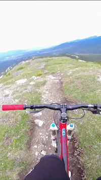
Photos of Grey Mountain Mountain Bike
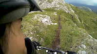
Videos of Grey Mountain Mountain Bike
0:05 |
9 |
Dec 29, 2025
trail: The Dream
0:42 |
20 |
Jul 6, 2025

trail: Money Shot
3:24 |
188 |
Jan 2, 2019
trail: Money Shot
0:22 |
127 |
Jun 27, 2016
trail: Money Shot
20:30 |
804 |
Sep 16, 2013
trail: Money Shot
0:59 |
1020 |
Nov 13, 2012
youtuber
![Boogaloo]()
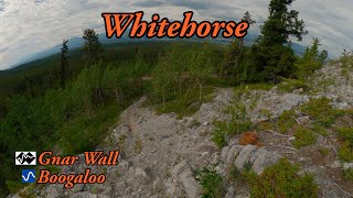
trail: Lower Boogaloo
12:48 |
79 |
Jun 28, 2025 , Whitehorse
youtuber
![Boogaloo]()

trail: Upper Boogaloo
12:48 |
79 |
Jun 28, 2025 , Whitehorse
Recent Trail Reports
Activity Feed
| username | action | type | title | date |
|---|---|---|---|---|
| Steveng84oCc | ridden | trail | activity #99032680 | Jul 12, 2026 @ 9:49am 23 hours |
| Mapa | comment | trail | activity #98957377 | Jul 11, 2026 @ 11:50am 2 days |
| Mapa | vote | trail | activity #98957318 | Jul 11, 2026 @ 11:49am 2 days |
| Mapa | vote | trail | activity #98614362 and 4 more | Jul 6, 2026 @ 7:28pm Jul 6, 2026 |
| Kendo147 | wishlist | trail | activity #98472109 | Jul 4, 2026 @ 9:33pm Jul 4, 2026 |
Recent Comments
| username | type | title | comment | date |
|---|---|---|---|---|
| trail | nice but nothing special. quite a bit of roots... | Jul 11, 2026 @ 11:50am 2 days | ||
| trail | Dry and fun. Echo the post above this one. | Jun 1, 2026 @ 6:47pm Jun 1, 2026 | ||
| report | Thanks to whoever cleared the tree :) | May 31, 2026 @ 7:41am May 31, 2026 | ||
| trail | April 30th, 2026 - snow 90% gone as far as the... | May 1, 2026 @ 6:31am May 1, 2026 | ||
| report | Thanks for grooming! It looked pretty good at... | Mar 19, 2026 @ 11:51pm Mar 19, 2026 |
Nearby Areas
| name | distance | ||||
|---|---|---|---|---|---|
| Whitehorse Airport | 4 | 4 | 2 | 2.5 km | |
| Hillcrest | 31 | 37 | 1 | 3.4 km | |
| Takhini | 5 | 7 | 4 km | ||
| Range Point | 2 | 1 | 4.6 km | ||
| Mt McIntyre | 22 | 45 | 5 | 1 | 4.7 km |
Local Badges
-

Completionist0 awarded
Local Mountain Biking Directory
-
Boréale BikingGuides & Tours
![Boréale Biking]()
-
Contagious Mountain Bike Club
![Contagious Mountain Bike Club]()
-
Cadence CyclesBike Shop
-
Icycle SportBike Shop
Activity Type Stats
| activitytype | trails | distance | descent | descent distance | total vertical | rating | global rank | state rank | photos | reports | routes | ridelogs |
|---|---|---|---|---|---|---|---|---|---|---|---|---|
| Mountain Bike | 98 | 111 miles | 18,514 ft | 46 miles | 2,703 ft | #677 | #1 | 562 | 3,448 | 24 | 11,040 | |
| E-Bike | 99 | 13 miles | 748 ft | 2 miles | 2,474 ft | #3,164 | #2 | 6 | 1,162 | 3 | 248 | |
| Winter Fat Bike | 1 | #647 | #1 | 16 | 32 | |||||||
| Horse | 2 | 7 miles | 66 ft | 3,251 ft | 2,116 ft | 220 | 1 | |||||
| Hike | 101 | 110 miles | 18,176 ft | 45 miles | 2,703 ft | #795 | #1 | 34 | 3,421 | 2 | 714 | |
| Trail Running | 101 | 110 miles | 18,176 ft | 45 miles | 2,703 ft | #187 | #1 | 3 | 3,421 | 2 | 1,366 | |
| Dirtbike/Moto | 1 | 7 miles | 66 ft | 3,251 ft | 2,116 ft | 210 | 4 | |||||
| Observed Trials | 2 | 7 miles | 66 ft | 3,251 ft | 2,116 ft | 23 | 3 | |||||
| ATV/ORV/OHV | 1 | 7 miles | 66 ft | 3,251 ft | 2,116 ft | 210 | 1 | |||||
| Snowmobile | 1 | 7 miles | 66 ft | 3,251 ft | 2,116 ft | 10 | ||||||
| Snowshoe | 4 | 10 miles | 285 ft | 1 mile | 2,116 ft | 156 | 1 | 10 | ||||
| Nordic Ski | 4 | 13 miles | 531 ft | 3 miles | 2,116 ft | 141 | 89 |
Frequently Asked Questions About Grey Mountain
▼
What are the highest rated mountain biking trails in Grey Mountain?
The highest rated mountain biking trails in Grey Mountain are:
- Hilarious (4.4/5)
- Money Shot (4.3/5)
- More Money (4.2/5)
- B&S (4.1/5)
- The Dream (4.1/5)
▼
What is the best time of the year to ride in Grey Mountain?
Based on ride log data, the most popular months to ride in Grey Mountain are:
- July (281 activities)
- June (269 activities)
- May (197 activities)
▼
Where can I park to ride in Grey Mountain?
There are 7 parking locations listed in Grey Mountain. The most popular parking spots are:
- Bottom of Grey Mountain Road
- Parking
- Parking Lot
- Upper Magnusson Parking Lot / Biathlon Parking Lot
- Grey Mountain Towers
▼
What is the longest trail in Grey Mountain?
The longest trail in Grey Mountain is Yukon River Trail at 6.9 km. View all trails sorted by distance.
Activities
Trails
Points of Interest
- By brenthillier
 NSMBA TRAILFORKS & contributors
 - Admins: brittseels, CMBC, COW, S2Syukon-trails
- #3349 - 25,806 views
- grey mountain activity log | embed map of Grey Mountain mountain bike trails | grey mountain mountain biking points of interest
Downloading of trail gps tracks in kml & gpx formats is enabled for Grey Mountain.
You must login to download files.