close
-
Layers w
- Weather Layers
- Pro
- Pro
- Pro
- Pro
- Pro
- Pro
- More Layers
- Pro
- Pro
- Pro
- Pro
-
Upgrade to

3D
Trail Conditions
- Unknown
- Snow Groomed
- Snow Packed
- Snow Covered
- Snow Cover Partial
- Freeze/thaw Cycle
- Icy
- Prevalent Mud
- Wet
- Variable
- Ideal
- Dry
- Very Dry
Trail Flow (Ridden Direction)
Trailforks scans users ridelogs to determine the most popular direction each trail is ridden. A good flowing trail network will have most trails flowing in a single direction according to their intension.
The colour categories are based on what percentage of riders are riding a trail in its intended direction.
The colour categories are based on what percentage of riders are riding a trail in its intended direction.
- > 96%
- > 90%
- > 80%
- > 70%
- > 50%
- < 50%
- bi-directional trail
- no data
Trail Last Ridden
Trailforks scans ridelogs to determine the last time a trail was ridden.
- < 2 days
- < 1 week
- < 2 weeks
- < 1 month
- < 6 months
- > 6 months
Trail Ridden Direction
The intended direction a trail should be ridden.
- Downhill Only
- Downhill Primary
- Both Directions
- Uphill Primary
- Uphill Only
- One Direction
Contribute Details
Colors indicate trail is missing specified detail.
- Description
- Photos
- Description & Photos
- Videos
Trail Popularity ?
Trailforks scans ridelogs to determine which trails are ridden the most in the last 9 months.
Trails are compared with nearby trails in the same city region with a possible 25 colour shades.
Think of this as a heatmap, more rides = more kinetic energy = warmer colors.
- most popular
- popular
- less popular
- not popular
ATV/ORV/OHV Filter
Max Vehicle Width
inches
US Cell Coverage
Legend

Radar Time
Activity Recordings
Trailforks uses anonymized public activity data.
?
Activity Recordings
Trailforks uses anonymized public activity data.
?
Personal Heatmap
▶
Activity Types
all
/
none
▶
Options
2
Date range
month
–
Winter Trails
Warning
A routing network for winter maps does not exist. Selecting trails using the winter trails layer has been disabled.
Missing Trails
Most Popular
Least Popular
Trails are colored based on popularity. The more popular a trail is, the more red. Less popular trails trend towards green.
Jump Magnitude Heatmap
Heatmap of where riders jump on trails. Zoom in to see individual jumps, click circles to view jump details.
BC Backroad Status
![map legend]()
Service Road Atlas is a free to use, community-driven service for viewing and creating reports on the numerous back-country service roads around B.C. and Alberta.

Slope Aspect
Direction the slope faces
Trails Deemphasized
Trails are shown in grey.
Only show trails with no bike usage.
Suggested Layers
Based on selected activity type
Save the current map location and zoom level as your default home location whenever this page is loaded.
Save
No description for Gunnison has been added yet!
Login or register to submit one.
Activities Click to view
- Mountain Bike
152 trails
- E-Bike
114 trails
- Gravel Bike
21 trails
- Adaptive Bike
34 trails
- Horse
53 trails
- Hike
165 trails
- Trail Running
165 trails
- Dirtbike/Moto
54 trails
- ATV/ORV/OHV
20 trails
- Snowmobile
4 trails
- Snowshoe
12 trails
- Downhill Ski
6 trails
- Backcountry Ski
8 trails
- Nordic Ski
11 trails
Region Details
- 49
- 5
- 27
- 54
- 16
- 1
Region Status
Open as of Jun 13, 2026Local Trail Association
Stats
- Avg Trail Rating
- Trails (view details)
- 183
- Trails Mountain Bike
- 152
- Trails E-Bike
- 114
- Trails Gravel Bike
- 21
- Trails Adaptive Bike
- 34
- Trails Horse
- 53
- Trails Hike
- 165
- Trails Trail Running
- 165
- Trails Dirtbike/Moto
- 54
- Trails ATV/ORV/OHV
- 20
- Trails Snowmobile
- 4
- Trails Snowshoe
- 12
- Trails Downhill Ski
- 6
- Trails Backcountry Ski
- 8
- Trails Nordic Ski
- 11
- Total Distance
- 297 miles
- Total Descent
- 38,710 ft
- Total Vertical
- 5,669 ft
- Highest Trailhead
- 13,198 ft
- Reports
- 498
- Photos
- 164
- Ridden Counter
- 44,469
Articles
Video: 'Underexposed' Explores Undiscovered Gunnison, Colorado
Jun 24, 2023 from pinkbike.com
A self-shot and produced series dedicated to showcasing trail advocacy and stewardship.
Back to the Trails: Gunnison, Colorado
Jul 6, 2020 from pinkbike.com
Gunnison is a literal wide-open playground for riders and is also now wide open for visitors as well.
Sub Regions
-
Hartman Rocks
- 2
- 16
- 30
- 11
- 1
-
Signal Peak
- 8
- 12
- 1
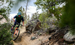
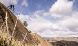
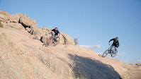
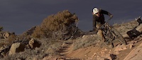
Popular Gunnison Mountain Biking Trails
• 100 ★ 4.4 • 1,919 ft • 151 ft • 1,509 •
Highly rated popular blue difficulty singletrack. This multi-use trail can be used uphill primary and has a moderate overall physical rating with a 151 ft blue climb. On average it takes 4 minutes to complete this trail.
• 100 ★ 4.1 • 1,932 ft • 0 ft • 1,441 •
Highly rated popular blue difficulty singletrack. This multi-use trail can be used both directions and has a moderate overall physical rating with a 0 ft blue climb. On average it takes 1 minutes to complete this trail.
• 95 ★ 4.2 • 3,182 ft • 81 ft • 1,422 •
Highly rated popular blue difficulty singletrack. This multi-use trail can be used both directions and has a moderate overall physical rating with a 81 ft blue climb. On average it takes 5 minutes to complete this trail.
• 100 ★ 4.4 • 2,405 ft • 125 ft • 1,359 •
Popular green difficulty singletrack. This multi-use trail can be used downhill primary and has a easy overall physical rating with a 125 ft green climb. On average it takes 4 minutes to complete this trail.
• 95 ★ 4.6 • 5,089 ft • 221 ft • 1,200 •
Highly rated popular black diamond difficulty singletrack. This multi-use trail can be used downhill primary and has a hard overall physical rating with a 221 ft black diamond climb. On average it takes 12 minutes to complete this trail.
• 5 ★ 4.3 • 2 miles • 332 ft • 1,188 •
Highly rated less popular blue difficulty singletrack. This multi-use trail can be used both directions and has a moderate overall physical rating with a 332 ft blue climb. On average it takes 15 minutes to complete this trail.
• 95 ★ 3.8 • 1 mile • 223 ft • 1,081 •
Popular green difficulty singletrack. This multi-use trail can be used both directions and has a easy overall physical rating with a 223 ft green climb. On average it takes 11 minutes to complete this trail.
Gunnison Mountain Bike Routes
★ 5.0 • 11 miles • 1,504 ft • 24 •
This loop hits most of the fun technical trails in Hartmans Rocks. You can take the at the top of to cut...
★ 5.0 • 17 miles • 2,331 ft • 52 •
Start up jacks, then head over to to the ridge. After ride up Top of the World, and use the cutoff trail...
★ 5.0 • 18 miles • 2,226 ft • 11 •
A fun loop covering the more cross-country trails of Hartman Rocks
9 miles • 1,272 ft • 7 •
★ 1.0 • 1 mile • 99 ft • 1 • Point to Point •
A short singletrack that packs punch. More technical in its nature, offers slick rock rolls and high-speed...
12 miles • 1,736 ft • 15 • Loop •
This is a recommend ride from in Gunnison, CO. This loop at Hartman Rocks has some technical sections and...
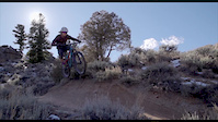
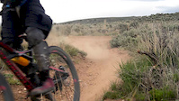
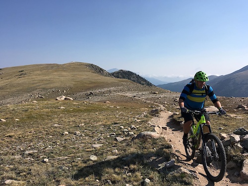
Photos of Gunnison Mountain Bike
Videos of Gunnison Mountain Bike

trail: Hartman Rocks Dr
0:05 |
683 |
Oct 14, 2020
trail: Behind the Rocks
0:58 |
126 |
Jan 15, 2020
trail: Skull Pass
0:53 |
423 |
Nov 13, 2018
trail: Free Fall
0:30 |
1100 |
Nov 27, 2017
trail: Becks
0:17 |
149 |
May 22, 2016
trail: Jacks
2:16 |
154 |
Sep 8, 2014
trail: Jacks
0:21 |
677 |
Sep 7, 2014
trail: Back In
13:08 |
455 |
Dec 10, 2013
Recent Trail Reports
| status | trail | date | condition | info | user |
|---|---|---|---|---|---|
| Gold Basin Road | Jun 13, 2026 @ 9:14am (America/Denver) Jun 13, 2026 | Unknown | benny503k4W | ||
| North Bank Campground Road | Jun 6, 2026 @ 10:01am (America/Denver) Jun 6, 2026 | Very Dry | Kcfarley | ||
| Jacks | Apr 10, 2026 @ 11:53am (America/Denver) Apr 10, 2026 | Dry | acornty | ||
| Lower Jacks | Apr 10, 2026 @ 11:53am (America/Denver) Apr 10, 2026 | Dry | acornty | ||
| Collarbone Alley | Apr 10, 2026 @ 11:53am (America/Denver) Apr 10, 2026 | Dry | acornty | ||
| Behind the Rocks | Apr 10, 2026 @ 11:53am (America/Denver) Apr 10, 2026 | Dry | acornty | ||
| Behind the Rocks Access | Apr 10, 2026 @ 11:53am (America/Denver) Apr 10, 2026 | Dry | acornty | ||
| Becks | Apr 10, 2026 @ 11:53am (America/Denver) Apr 10, 2026 | Dry | acornty | ||
| Sky Line | Oct 28, 2025 @ 9:26am (America/Denver) Oct 28, 2025 | Ideal | acornty | ||
| Lost Dog | Aug 10, 2025 @ 12:13pm Aug 10, 2025 | Dry | Thomas9wVvja |
National Scenic Trails & Official Routes
-
Colorado Trail (Bike)
- Mountain Bike
Activity Feed
| username | action | type | title | date |
|---|---|---|---|---|
| machoprincess | comment | trail | activity #97636886 | Jun 23, 2026 @ 10:29am 1 hours |
| bordon | wishlist | route | activity #97620710 | Jun 23, 2026 @ 5:57am 6 hours |
| jbiendara | wishlist | route | activity #97590133 | Jun 22, 2026 @ 4:06pm 20 hours |
| mrbustr | wishlist | route | activity #97478970 | Jun 21, 2026 @ 6:39am 2 days |
| Ckareth | wishlist | trail | activity #97459425 | Jun 21, 2026 @ 12:36am 2 days |
Recent Comments
| username | type | title | comment | date |
|---|---|---|---|---|
| trail | this trail is great if the thing you're... | Jun 23, 2026 @ 10:29am 1 hours | ||
| trail | Very nicely laid out as a climbing trail -... | May 10, 2026 @ 8:12pm May 10, 2026 | ||
| trail | felt super hard my first run. once you figure... | Apr 24, 2026 @ 12:28pm Apr 24, 2026 | ||
| trail | agree it's a very good and fairly challenging... | Apr 24, 2026 @ 12:10pm Apr 24, 2026 | ||
| trail | Yep, it's not Rattlesnake! Personally I find... | Apr 5, 2026 @ 6:44pm Apr 5, 2026 |
Local Badges
-

Top 10 Trails34 awarded -

Descent 100k Badge7 awarded -

Big Ride 30k1,840 awarded -

Epic Ride 50k660 awarded -

Descent 10k Badge73 awarded -

Completionist0 awarded
Bike & Skill Parks
| name | type | city | rating |
|---|---|---|---|
| Hartman Rocks Jump Park | skill park | Gunnison |
Local Mountain Biking Directory
-
Gunnison Trails
![Gunnison Trails]()
-
Rock N Roll SportsBike Shop
-
All Sports ReplayBike Shop
-
Tomichi CyclesBike Shop
-
Race Townie BicyclesBike Shop
Local Products
Activity Type Stats
| activitytype | trails | distance | descent | descent distance | total vertical | rating | global rank | state rank | photos | reports | routes | ridelogs |
|---|---|---|---|---|---|---|---|---|---|---|---|---|
| Mountain Bike | 152 | 245 miles | 29,321 ft | 92 miles | 5,062 ft | #478 | #173 | 144 | 498 | 29 | 17,726 | |
| E-Bike | 114 | 176 miles | 20,614 ft | 67 miles | 5,062 ft | #499 | #719 | 18 | 471 | 3 | 657 | |
| Gravel Bike | 21 | 32 miles | 4,239 ft | 13 miles | 2,697 ft | #335 | #941 | 23 | 1 | 110 | ||
| Adaptive Bike | 34 | 54 miles | 6,332 ft | 25 miles | 2,762 ft | #262 | #1,574 | 53 | ||||
| Horse | 53 | 90 miles | 12,792 ft | 38 miles | 3,684 ft | #635 | #532 | 151 | 2 | |||
| Hike | 165 | 284 miles | 36,555 ft | 106 miles | 5,669 ft | #598 | #274 | 498 | 5 | 1,589 | ||
| Trail Running | 165 | 284 miles | 36,555 ft | 106 miles | 5,669 ft | #424 | #169 | 2 | 496 | 5 | 1,597 | |
| Dirtbike/Moto | 54 | 93 miles | 13,346 ft | 38 miles | 4,327 ft | #308 | #141 | 157 | 1 | 25 | ||
| ATV/ORV/OHV | 20 | 44 miles | 4,616 ft | 16 miles | 2,999 ft | #479 | #161 | 140 | 2 | |||
| Snowmobile | 4 | 15 miles | 203 ft | 3,835 ft | 2,802 ft | #227 | #107 | 3 | ||||
| Snowshoe | 12 | 44 miles | 4,308 ft | 10 miles | 3,556 ft | #512 | #183 | 2 | 10 | |||
| Downhill Ski | 6 | 1 mile | 1,234 ft | 1 mile | 312 ft | #670 | #316 | 12 | ||||
| Backcountry Ski | 8 | 20 miles | 761 ft | 4 miles | 2,930 ft | #442 | #103 | 1 | 80 | |||
| Nordic Ski | 11 | 11 miles | 837 ft | 3 miles | 1,808 ft | #803 | #314 | 1 | 307 |
Frequently Asked Questions About Gunnison
▼
What are the best places to ride in Gunnison?
Gunnison has 6 areas to explore for mountain biking. The top rated areas are:
▼
What are the highest rated mountain biking trails in Gunnison?
The highest rated mountain biking trails in Gunnison are:
- Gateway (4.5/5)
- The Ridge (4.4/5)
- Rattlesnake (4.4/5)
- Free Fall (4.4/5)
- Josho's (4.3/5)
▼
What is the best time of the year to ride in Gunnison?
Based on ride log data, the most popular months to ride in Gunnison are:
- July (238 activities)
- August (126 activities)
- September (116 activities)
▼
Where can I park to ride in Gunnison?
There are 25 parking locations listed in Gunnison. The most popular parking spots are: View all parking and trailhead locations on the map to plan your visit.
Activities
- Gunnison Mountain Biking Trails
- Gunnison E-Biking Trails
- Gunnison Gravel Biking Trails
- Gunnison Adaptive Biking Trails
- Gunnison Horseback Trails
- Gunnison Hiking Trails
- Gunnison Trail Running Trails
- Gunnison Dirtbiking Trails
- Gunnison ATVing/Offroading Trails
- Gunnison Snowshoeing Trails
- Gunnison Skiing Trails
- Gunnison Backcountry Skiing Trails
- Gunnison Nordic Skiing Trails
Trails
Points of Interest
- By mountainbikesoul & contributors
- Admins: Gunnison, SJMA
- #6400 - 15,122 views
- gunnison activity log | embed map of Gunnison mountain bike trails | gunnison mountain biking points of interest
Downloading of trail gps tracks in kml & gpx formats is enabled for Gunnison.
You must login to download files.