close
-
Layers w
- Weather Layers
- Pro
- Pro
- Pro
- Pro
- Pro
- Pro
- More Layers
- Pro
- Pro
- Pro
- Pro
-
Upgrade to

3D
Trail Conditions
- Unknown
- Snow Groomed
- Snow Packed
- Snow Covered
- Snow Cover Partial
- Freeze/thaw Cycle
- Icy
- Prevalent Mud
- Wet
- Variable
- Ideal
- Dry
- Very Dry
Trail Flow (Ridden Direction)
Trailforks scans users ridelogs to determine the most popular direction each trail is ridden. A good flowing trail network will have most trails flowing in a single direction according to their intension.
The colour categories are based on what percentage of riders are riding a trail in its intended direction.
The colour categories are based on what percentage of riders are riding a trail in its intended direction.
- > 96%
- > 90%
- > 80%
- > 70%
- > 50%
- < 50%
- bi-directional trail
- no data
Trail Last Ridden
Trailforks scans ridelogs to determine the last time a trail was ridden.
- < 2 days
- < 1 week
- < 2 weeks
- < 1 month
- < 6 months
- > 6 months
Trail Ridden Direction
The intended direction a trail should be ridden.
- Downhill Only
- Downhill Primary
- Both Directions
- Uphill Primary
- Uphill Only
- One Direction
Contribute Details
Colors indicate trail is missing specified detail.
- Description
- Photos
- Description & Photos
- Videos
Trail Popularity ?
Trailforks scans ridelogs to determine which trails are ridden the most in the last 9 months.
Trails are compared with nearby trails in the same city region with a possible 25 colour shades.
Think of this as a heatmap, more rides = more kinetic energy = warmer colors.
- most popular
- popular
- less popular
- not popular
ATV/ORV/OHV Filter
Max Vehicle Width
inches
US Cell Coverage
Legend

Radar Time
Activity Recordings
Trailforks uses anonymized public activity data.
?
Activity Recordings
Trailforks uses anonymized public activity data.
?
Personal Heatmap
▶
Activity Types
all
/
none
▶
Options
2
Date range
month
–
Winter Trails
Warning
A routing network for winter maps does not exist. Selecting trails using the winter trails layer has been disabled.
Missing Trails
Most Popular
Least Popular
Trails are colored based on popularity. The more popular a trail is, the more red. Less popular trails trend towards green.
Jump Magnitude Heatmap
Heatmap of where riders jump on trails. Zoom in to see individual jumps, click circles to view jump details.
BC Backroad Status
![map legend]()
Service Road Atlas is a free to use, community-driven service for viewing and creating reports on the numerous back-country service roads around B.C. and Alberta.

Slope Aspect
Direction the slope faces
Trails Deemphasized
Trails are shown in grey.
Only show trails with no bike usage.
Suggested Layers
Based on selected activity type
Save the current map location and zoom level as your default home location whenever this page is loaded.
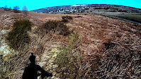
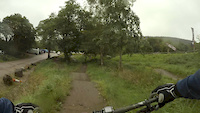
SaveBeautiful play area of open land, old mine workings, easy riding tracks, narrow natural tracks & fun play areas. Away from the trails indicated here are many km of grassy double track linking every section. Great place to know as it is still ride-able even in poor weather and after heavy rain (only a few tracks get swampy - Toboggan Run & main track along the ridge). Access is a grey area as the common is not an open access area as such but the area has been ridden for many many years. A number of legal rights of way cross the area but these are not well marked. Be courteous to other users (walkers, dog walkers, horse riders, etc) i.e. slow down. 
Primary Trail Type: Cross-Country
Shuttleable: YES
 google parking directions
This region uses the Uk/Euro style trail grading system.
Activities Click to view
- Mountain Bike
81 trails
- Hike
81 trails
- Trail Running
81 trails
Region Details
- 4
- 25
- 36
- 16
Region Status
Open as of Jan 20, 2026Stats
- Avg Trail Rating
- Trails (view details)
- 81
- Trails Mountain Bike
- 81
- Trails Horse
- 1
- Trails Hike
- 81
- Trails Trail Running
- 81
- Total Distance
- 26 miles
- Total Descent
- 5,000 ft
- Total Vertical
- 355 ft
- Highest Trailhead
- 990 ft
- Reports
- 558
- Photos
- 19
- Ridden Counter
- 691
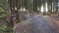
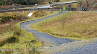
Popular Halkyn Mountain Mountain Biking Trails
• 5 ★ 4.0 • 1,581 ft • 0 ft • 24 •
Narrow single track follows natural path line down hills side. Take care on track crossings and junctions for other users. Avoid riding in the wet to prevent erosion.
• 5 ★ 2.0 • 923 ft • 5 ft • 22 •
Short tech skills trail. Be careful of first drop off in wet as landing is slippery. Sharp right turn brings you to second rocky drop which can be slippery.
• 5 ★ 0.0 • 691 ft • 0 ft • 21 •
Follow the small gully down on right of track. End by heading left down steep ramp. Can go right to extend but currently no good 'exit'
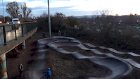
• 95 ★ 5.0 • 1,386 ft • 4 ft • 20 •
Best line through the old mine workings. Always narrow. Bottom section ALL pump.
• 5 ★ 3.5 • 1,032 ft • 3 ft • 18 •
Avoid when wet to prevent erosion. Great small section of single.
• 5 ★ 4.0 • 2,294 ft • 0 ft • 17 •
Straight line descent from trig point to Rhys y Cae. Gets chewed up when wet. Popular dog walking trail - be careful of other users. Always give way.
• 5 ★ 2.0 • 1,316 ft • 51 ft • 16 •
Link trail between Halkyn Mountain & Holywell Common
Halkyn Mountain Mountain Bike Routes
★ 3.0 • 11 miles • 1,063 ft • 10 • Loop •
Taking in some of the local, candy inspired Strava sections, this is an old skool loop I used to do with...
Photos of Halkyn Mountain Mountain Bike
Videos of Halkyn Mountain Mountain Bike
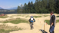
trail: Pump Track
0:35 |
155 |
Jan 18, 2019
trail: Criosote
0:25 |
104 |
Mar 28, 2018
trail: Pump Track
0:21 |
100 |
Dec 2, 2017
trail: Pump Track
0:01 |
219 |
Sep 16, 2017
trail: Pump Track
0:07 |
48 |
Mar 13, 2017
trail: Pump Track
0:19 |
185 |
Dec 10, 2016
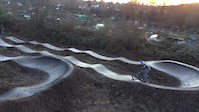
trail: Pump Track
0:20 |
84 |
Dec 10, 2016

trail: Pump Track
0:51 |
97 |
Dec 2, 2016
Recent Trail Reports
| status | trail | date | condition | info | user |
|---|---|---|---|---|---|
| Downtown Abbey | Jan 20, 2026 @ 7:04pm (Europe/London) Jan 20, 2026 | Wet | rocktapa | ||
| Curly Wurly | Jan 20, 2026 @ 7:04pm (Europe/London) Jan 20, 2026 | Prevalent Mud | rocktapa | ||
| Pond Life | Nov 27, 2025 @ 6:28pm (Europe/London) Nov 27, 2025 | Wet | rocktapa | ||
| Pant-y-Ffrith Track | Nov 27, 2025 @ 6:28pm (Europe/London) Nov 27, 2025 | Wet | rocktapa | ||
| Under The Pylon | Nov 27, 2025 @ 6:28pm (Europe/London) Nov 27, 2025 | Prevalent Mud | rocktapa | ||
| Lion Bar | Nov 27, 2025 @ 6:28pm (Europe/London) Nov 27, 2025 | Prevalent Mud | rocktapa | ||
| Down the Ditch | Nov 27, 2025 @ 6:28pm (Europe/London) Nov 27, 2025 | Wet | rocktapa | ||
| Rio | Oct 14, 2025 @ 7:09pm (Europe/Isle_of_Man) Oct 14, 2025 | Ideal | rocktapa | ||
| Roller Coaster | Oct 14, 2025 @ 7:09pm (Europe/Isle_of_Man) Oct 14, 2025 | Ideal | rocktapa | ||
| Kav's Way | Oct 14, 2025 @ 7:09pm (Europe/Isle_of_Man) Oct 14, 2025 | Ideal | rocktapa |
Activity Feed
| username | action | type | title | date |
|---|---|---|---|---|
| Nathanowen26 | wishlist | region | activity #95933785 | May 31, 2026 @ 6:34am May 31, 2026 |
| MatthewYiAoTc | wishlist | route | activity #95349085 | May 23, 2026 @ 1:13pm May 23, 2026 |
| trailforks | add | video | activity #87661450 | Jan 22, 2026 @ 10:00pm Jan 22, 2026 |
| rocktapa | add | report | activity #87565242 and 1 more | Jan 21, 2026 @ 1:04am Jan 21, 2026 |
| trailforks | add | video | activity #86804562 | Jan 7, 2026 @ 10:23am Jan 7, 2026 |
Recent Comments
| username | type | title | comment | date |
|---|---|---|---|---|
| trail | Switch when it joins onto on the rails for a... | Jul 20, 2021 @ 4:10pm Jul 20, 2021 | ||
| trail | Good for training if you ride up it! | Apr 13, 2020 @ 1:03pm Apr 13, 2020 |
Nearby Areas
| name | distance | ||||
|---|---|---|---|---|---|
| Clwydian Range | 12 | 24 | 5.7 km | ||
| Llandegla Forest | 13.2 km | ||||
| Llandegla | 2 | 13.4 km | |||
| Foel Gasnach | 1 | 4 | 14 km | ||
| Llyn Brenig | 3 | 1 | 17.4 km |
Local Badges
-

Completionist0 awarded
Activity Type Stats
| activitytype | trails | distance | descent | descent distance | total vertical | rating | global rank | state rank | photos | reports | routes | ridelogs |
|---|---|---|---|---|---|---|---|---|---|---|---|---|
| Mountain Bike | 81 | 26 miles | 5,000 ft | 16 miles | 354 ft | #4,692 | #141 | 19 | 558 | 1 | 1,187 | |
| Horse | 1 | 2,684 ft | 20 ft | 1,106 ft | 56 ft | 136 | ||||||
| Hike | 81 | 26 miles | 5,000 ft | 16 miles | 354 ft | #5,333 | #101 | 553 | 8 | |||
| Trail Running | 81 | 26 miles | 5,000 ft | 16 miles | 354 ft | #4,412 | #90 | 553 | 34 |
Frequently Asked Questions About Halkyn Mountain
▼
What are the highest rated mountain biking trails in Halkyn Mountain?
The highest rated mountain biking trails in Halkyn Mountain are:
- Pump Track (4.1/5)
- Swizzle Down The Wind (4.1/5)
- On the Rails (4/5)
- Toboggan Run (4/5)
- Criosote (4/5)
▼
What is the best time of the year to ride in Halkyn Mountain?
Based on ride log data, the most popular months to ride in Halkyn Mountain are:
- April (20 activities)
- May (13 activities)
- July (12 activities)
▼
Where can I park to ride in Halkyn Mountain?
▼
What is the longest trail in Halkyn Mountain?
The longest trail in Halkyn Mountain is Swizzle Down The Wind at 1.9 km. View all trails sorted by distance.
Activities
Trails
Points of Interest
- By rocktapa
 & contributors
 - Admins: TCNW, rocktapa
- #21660 - 8,020 views
- halkyn mountain activity log | embed map of Halkyn Mountain mountain bike trails | halkyn mountain mountain biking points of interest
Downloading of trail gps tracks in kml & gpx formats is enabled for Halkyn Mountain.
You must login to download files.